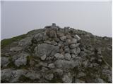
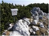
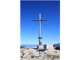
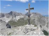
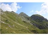
 | Sella Nevea - Prestreljenik (on ski track)
Prestreljenik is a 2,499 m high mountain located in the heart of the Kanin range. From the summit, where there is a registration box shaped like ...
3 h 30 min |
 | Ljubelj - Begunjščica (via Zelenica)
Begunjščica is a mountain range in the Karawanks east of Stol. Its highest peak is Veliki Vrh, which at over 2,000 m offers a fine view across ce...
3 h 50 min |
| Tinčkova koča - Begunjščica
Begunjščica is a mountain range in the Karawanks east of Stol. Its highest peak is Veliki Vrh, which at over 2,000 m offers a fine view across ce...
3 h 15 min |
 | Tinčkova koča - Begunjščica (via Poljška planina)
Begunjščica is a mountain range in the Karawanks east of Stol. Its highest peak is Veliki Vrh, which at over 2,000 m offers a fine view across ce...
3 h 50 min |
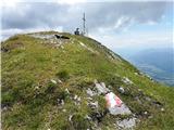
 | Johannsenruhe - Hochstuhl/Stol (via Klagenfurter Hütte)
Stol is, at 2,236 m, the highest peak in the Karawanks. From the summit, which has a registration box and stamp, a beautiful view opens onto the ...
3 h 45 min |
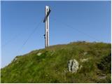
 | Vranček - Loibler Baba/Košutica (western way)
Košutica (also known as Ljubeljska Baba) is a panoramic mountain north of the western ridge of Košuta. From the summit, marked by a small cross a...
2 h 50 min |
 | Planina Zajavornik - Viševnik
Viševnik is a 2050 m high mountain rising northwest of Rudno polje on Pokljuka. From the summit, where there is a stamp, a beautiful view opens o...
3 h 30 min |
 | Uskovnica (Lom) - Viševnik (via Srenjski preval)
Viševnik is a 2050 m high mountain rising northwest of Rudno polje on Pokljuka. From the summit, where there is a stamp, a beautiful view opens o...
3 h 10 min |
| Uskovnica (Razpotje) - Viševnik (via Srenjski preval)
Viševnik is a 2050 m high mountain rising northwest of Rudno polje on Pokljuka. From the summit, where there is a stamp, a beautiful view opens o...
2 h 55 min |
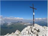
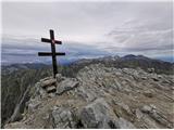
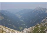
 | Ljubelj - Vertatscha/Vrtača
Vrtača is a 2181 m high peak located east of Stol. From the summit, where a large peg stands, a beautiful view opens over parts of the Julian Alp...
3 h 30 min |
| Tinčkova koča - Vertatscha/Vrtača (via Smuška planina in saddle Šija)
Vrtača is a 2181 m high peak located east of Stol. From the summit, where a large peg stands, a beautiful view opens over parts of the Julian Alp...
3 h 30 min |
| Trate / Johannsenruhe - Vertatscha/Vrtača
Vrtača is a 2181 m high peak located east of Stol. From the summit, where a large peg stands, a beautiful view opens over parts of the Julian Alp...
4 h |
 | Trate / Johannsenruhe - Prešernova koča na Stolu (via Celovška koča)
The Prešernova koča na Stolu mountain hut is located just a few metres below the summit of the 2198 m high Mali Stol. From the hut or the nearby ...
3 h 40 min |
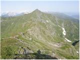
 | Kokra (Roblek) - Vrh Korena
Vrh Korena is located between Zvoh and Kalški greben near the Krvavec ski resort. The summit offers a beautiful view of the highest peaks in the ...
3 h |
 | Kokra (Roblek) - Kalški greben
Kalški greben is a 2224 m high peak and the highest point of the ridge bearing the same name. From the summit, where there is a summit register a...
3 h 55 min |
 | Ravenska Kočna - Ledinski vrh (hunter's way)
The mountain is located above Jezersko and lies on the border with Austria. From the summit there is a beautiful view north towards the neighbour...
3 h 30 min |
| Koča pod slapom Rinka - Ledinski vrh
The mountain is located above Jezersko and lies on the border with Austria. From the summit there is a beautiful view north towards the neighbour...
3 h 30 min |
 | Velacher Kotschna/Belska Kočna - Ledinski vrh
The mountain is located above Jezersko and lies on the border with Austria. From the summit there is a beautiful view north towards the neighbour...
3 h 45 min |
 | Matizovec - Veliko Kladivo
Veliko Kladivo is a 2094 m high peak in the longest Slovenian ridge, Košuta. From the summit, which has a register box and stamp, there is a very...
3 h 20 min |
| Globoka dolina - Veliko Kladivo
Veliko Kladivo is a 2094 m high peak in the longest Slovenian ridge, Košuta. From the summit, which has a register box and stamp, there is a very...
3 h |
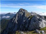
 | Planina Kuhinja - Batognica
Batognica is a 2164 m high mountain that was the site of the so-called mine warfare during World War I. Remnants of the fighting between Italian ...
3 h 20 min |
 | Bele Vode - Jerebica
Jerebica is a mountain located on the border between Slovenia and Italy, between the Možnica and Jezerska valleys. From the summit, where there i...
3 h 30 min |
 | Markova raven - Košutna (marked way)
The summit is located between Kompotela and the mountain pasture Košutna. From the top, there is a beautiful view toward Krvavec and Kalški grebe...
2 h 50 min |
 | Matizovec - Malo Kladivo
Malo Kladivo is located in the Košuta ridge. From the summit, which has no registration box, there is a nice view toward the neighboring Veliko K...
3 h 5 min |
 | Planina Kuk - Vrh nad Škrbino (direct way)
Vrh nad Škrbino is the easternmost two-thousander in the ridge of the Lower Bohinj Mountains. From the summit, there are excellent views of the n...
3 h 15 min |
| Tolminske Ravne - Vrh nad Škrbino (on mule track and direct way)
Vrh nad Škrbino is the easternmost two-thousander in the ridge of the Lower Bohinj Mountains. From the summit, there are excellent views of the n...
4 h |
 | Raabtal - Steinkarspitz/Monte Antola
Steinkarspitz (Monte Antola in Italian) is a 2,524-meter-high mountain on the border ridge between Austria and Italy. From its grassy summit, the...
2 h 45 min |
 | Raabtal - Monte Vancomun / Hochspitz
Monte Vancomun / Hochspitz is a 2,580-meter-high mountain located south of the upper Gail Valley. From the summit, which features a cross, there ...
3 h 15 min |
 | Planina Kuk - Zeleni vrh
Zeleni vrh is a 2052-meter-high mountain located east of the highest peak of the Spodnje Bohinjske gore. From the grassy summit, which drops prec...
4 h 5 min |
 | Tolminske Ravne - Zeleni vrh (via Dolina pod Ploščo)
Zeleni vrh is a 2052-meter-high mountain located east of the highest peak of the Spodnje Bohinjske gore. From the grassy summit, which drops prec...
4 h 10 min |
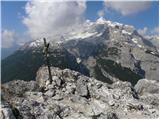
 | Drei Zinnen Blick - Strudelköpf / Monte Specie
Strudelköpf / Monte Specie is a 2307-meter-high grassy peak located in Fanes-Sennes-Prags Nature Park. A large cross stands on the summit, erecte...
3 h |
 | San Martino - Cima della Rosetta
Cima della Rosetta is a 2,743-meter-high peak rising above the settlement of San Martino. From the summit, where a cross stands, there is a nice ...
3 h 40 min |
 | Fiames - Col Rosa
Col Rosa is a 2,166-meter-high mountain situated north of Cortina d'Ampezzo. From the summit, where a cross stands, there is a very nice view of ...
2 h 45 min |
 | Rifugio Pederü - Muntejela de Sennes
Muntejela de Sennes (Monte Sella di Sennes) is a 2,787-meter-high peak in the Fanes-Sennes-Prags Nature Park. The summit is located west of the M...
3 h 30 min |
 | Klammbrückl - Weittalspitze
Weittalspitze is a 2539-meter-high peak in the Lienz Dolomites. The summit is located south of the Kerschbaumeralm pasture. From the top, where a...
3 h 30 min |
 | Landro - Monte Piano
Monte Piano (Toblacher Kreuz) is a 2,305-meter-high mountain located on the northwestern edge of the Monte Piana plateau. Near the summit there a...
2 h 50 min |
 | Kesselfall - Höhenburg
Höhenburg is a 2,108-metre mountain in the Glockner group of the High Tauern. It is located beside the Mooserboden reservoir. From the summit, wh...
3 h 50 min |
 | Rifugio Pederü - Col Bechei
Col Bechei (also Col Becchei, German Pareispitze, Italian Monte Parei) is a 2,794-meter-high peak above the Valle di Fanes and Valle di Rudo vall...
3 h 55 min |
 | Baita Rododendro - Monte Lastroni (Sentiero 138)
Monte Lastroni is a mountain in the western part of the central Carnic Alps, south of the source of the Piave River....
3 h |
 | Weißenbach - Spitzegel / Negal (25d)
Spitzegel / Negal is a 2,119 m high mountain in the Gailtal Alps in Austria. The ridge with its highest peak Spitzegel / Nagal logically connects...
3 h 40 min |
 | Casa da Monthana - Pico
Pico is Portugal's highest peak and the third highest in the Atlantic Ocean, located on Pico Island in the Azores archipelago. It is an active st...
3 h |
 | Collina - Cima Ombladet (path 141)
Cima Ombladet is a 2,255-meter-high mountain in the Carnic Alps east of the town of Forni Avoltri. From the summit, where a small cross stands, t...
3 h 20 min |
 | Rifugio Pederü - Bivacco Baccon Barborka
Bivacco Baccon Barborka is a small bivouac with four bunks. It is located near the summit of Furcia Rossa II, where large ruins from World War I ...
4 h 10 min |
 | Tri studničky - Kriváň
Mount Kriváň is the first prominent peak of the High Tatras when viewed from the west and belongs to Tatra National Park. It rises above the Lipt...
4 h |
 | Crno polje - Zelena glava
Zelena glava is the highest peak of the Prenj mountain range, located in northern Herzegovina south of Konjic and north of Mostar. From the summi...
4 h |
 | Parkplatz Tappenkarweg - Weißgrubenkopf (Parkplatz Tappenkarweg - Weißgrubenkopf)
Weißgrubenkopf is a 2,369-meter-high panoramic mountain at the far west of the Lower Tauern in the Austrian state of Salzburg. It is located dire...
3 h 30 min |
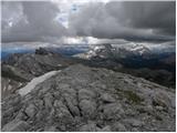
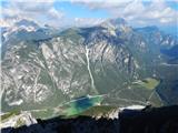
| Koča pod slapom Rinka - Skuta Glacier
Ledenik pod Skuto is today the largest glacier in Slovenia. Due to its location, it is in good condition and has been slightly expanding accordin...
4 h 10 min |
 | Planina Zajzera - Visoki Pipar / Monte Piper (path 648)
Visoki Pipar or Italian Monte Piper is, with 2069 meters, the highest and most easily accessible peak in the Pipar ridge in the Naborje mountains...
3 h |
 | Niederalpl Ort - Hohe Veitsch (through Rodel valley)
Hohe Veitsch is the highest peak of the Veitsch mountain range, located in the eastern part of the Northern Limestone Alps. From the summit, a be...
2 h 40 min |