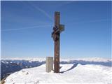
 | Dom na Gospincu - Veliki Zvoh
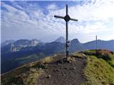
Veliki Zvoh is the highest point of the Krvavec ski resort. The cable car does not quite reach the summit but stops only a few metres short. A fe...
1 h 25 min |
| Kriška planina - Veliki Zvoh
Veliki Zvoh is the highest point of the Krvavec ski resort. The cable car does not quite reach the summit but stops only a few metres short. A fe...
1 h 25 min |
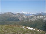
 | Snežniška Grda jama - Snežnik (via Mali Snežnik)
Snežnik, or Veliki Snežnik, at 1796 metres is the highest peak in the near and far surroundings, offering a beautiful view over a large part of S...
1 h 25 min |
 | Gašperjev hrib - Snežnik
Snežnik, or Veliki Snežnik, at 1796 metres is the highest peak in the near and far surroundings, offering a beautiful view over a large part of S...
1 h 30 min |
 | Gašperjev hrib - Snežnik
Snežnik, or Veliki Snežnik, at 1796 metres is the highest peak in the near and far surroundings, offering a beautiful view over a large part of S...
1 h 30 min |
| Sežanje - Snežnik
Snežnik, or Veliki Snežnik, at 1796 metres is the highest peak in the near and far surroundings, offering a beautiful view over a large part of S...
1 h 40 min |
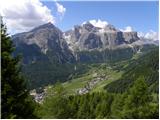
 | end of road on Vogar - Pršivec (direct way)
Pršivec is a panoramic mountain above Lake Bohinj. The view is extensive in all directions: Triglav and the surrounding mountains are clearly vis...
1 h 30 min |
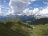
 | Planina Dol - Konj
Konj is an 1803 m high peak located between Velika Planina and Presedljaj. From the summit there is a beautiful view of the highest peaks of the ...
1 h 30 min |
 | Tonkina koča na Vršiču - Vršič vrh
Vršič is a 1,737-metre-high mountain situated between the Poštarski dom hut and the Vršič pass. From the summit, where there is a registration bo...
1 h |
 | Ski hotel Vogel - Šija
Šija is located above the Vogel ski resort in the Lower Bohinj Mountains. From the summit, there is a nice view of the neighboring peaks in the s...
1 h 30 min |
 | Tonkina koča na Vršiču - Sovna glava (on old road)
Sovna Glava is a 1750-meter-high grassy peak situated between Prisank and the Vršič Pass. From the summit, there is a nice view of the peaks risi...
1 h 10 min |
 | Salzstiegelhaus - Speikkogel (Packalpe)
Speikkogel is a spacious and grassy summit in the Packalpe mountain group. From the top, there is a beautiful view towards the Slovenian mountain...
1 h 15 min |
 | Rosstratte - Dobratsch / Dobrač (by road)
Dobrač, or in German Dobratsch and also known as Villacher Alpen, is a 2166-meter-high mountain situated on the far eastern edge of the Gailtal A...
1 h 20 min |
 | Turracher Höhe - Kornock (northern way)
Kornock is a panoramic peak located west of the Turracherhöhe mountain pass. The summit, which is also the highest point of the Turracherhöhe ski...
1 h 15 min |
 | Turracher Höhe - Schoberriegel
Schoberriegel is a 2,208 m high peak located between the Turracher Höhe alpine pass and the slightly higher Gruft. From the summit, where a cross...
1 h 20 min |
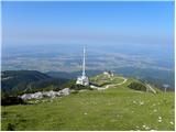 | Planina Jezerca - Krvavec
Krvavec is a 1,853-meter-high peak located in the heart of the eponymous ski resort. From the summit, which is crisscrossed with cable cars, ther...
1 h 10 min |
 | Planina Loka - Lanež (eastern way)
Lanež is a less distinct peak on the eastern part of Raduha. From the spacious summit a nice view opens on nearby Mala Raduha, Olševa, Peca, Uršl...
1 h 25 min |
| Planina Loka - Lanež (via Durce)
Lanež is a less distinct peak on the eastern part of Raduha. From the spacious summit a nice view opens on nearby Mala Raduha, Olševa, Peca, Uršl...
1 h 25 min |
 | Heidi Alm - Rodresnock (ridge path)
Rodresnock is a 2310 m high mountain rising southwest of Lake Falkertsee. From the summit, where a large cairn stands with a cross in its center,...
1 h 30 min |
 | Heidi Alm - Rodresnock (via Falkertscharte)
Rodresnock is a 2310 m high mountain rising southwest of Lake Falkertsee. From the summit, where a large cairn stands with a cross in its center,...
1 h 30 min |
 | Heidi Alm - Falkert (via Falkertscharte)
Falkert is a 2308 m high peak located west of the village and Lake Falkertsee. From the summit, which has a few benches, a summit logbox with sta...
1 h 30 min |
 | Heidi Alm - Falkert (direct way)
Falkert is a 2308 m high peak located west of the village and Lake Falkertsee. From the summit, which has a few benches, a summit logbox with sta...
1 h 15 min |
 | Heidi Alm - Falkert (via Hundsfeldscharte)
Falkert is a 2308 m high peak located west of the village and Lake Falkertsee. From the summit, which has a few benches, a summit logbox with sta...
1 h 30 min |
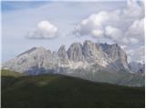 | Ciampac - Sas de Adam
Sas de Adam (also Sass de Dama) is a 2,430-meter-high peak situated north of the alpine valley Val Sen Nicolo. From the top, a nice view opens up...
1 h 40 min |
 | Ciampac - Brunec
Brunec is an almost 2,500-meter-high peak situated above the Campiac ski area in the Dolomites. From the top, a nice view opens up on Colac, Marm...
1 h |
 | Ski hotel Vogel - Visoki Orlov rob
Visoki Orlov rob is a 1,800-meter-high peak located right next to the upper station of the Šija single-chair lift. From the summit, which lies sl...
1 h 15 min |
 | Colfosco - Rifugio Col Pradat (by road)
The Rifugio Col Pradat mountain hut is situated at 2038 meters in the Puez mountain group. Due to its proximity to the ski area, the hut is well ...
1 h |
 | Weinebene Straße - Weberkogel
Weberkogel is a less prominent peak located north to northwest of the alpine pass Weinebene. On the 1805-meter-high summit stands a medium-sized ...
1 h 30 min |
 | Zettersfeld - Steinermandl
Steinermandl is a 2,235-meter-high peak in the Schober mountain group. Below the summit there is also a hut and the upper chairlift station. From...
1 h |
 | Rifugio Fedare - Monte Pore
Monte Pore or Spiz de Poure is a 2,405-meter-high grassy peak located west of the Averau and Nuvolau summits. From the top, where a large cross s...
1 h 30 min |
 | Klippitztörl - Forstalpe (Saualpe)
Forstalpe is an indistinct peak in the massif of Svinška planina / Saualpe. The stamp for Forstalpe is located in an interesting natural window, ...
1 h 40 min |
 | Wiesser Alm - Mirnock (Path 184)
Mirnock is a 2,110 m high isolated and highly panoramic mountain massif in Carinthia. It is part of the Nockberge group in the Gurktal Alps, loca...
1 h 30 min |
 | parking below Weinebene - Steinmandl (Golica / Koralpe) (via Grünangerhütte)
Steinmandl is a panoramic peak in the Golica/Koralpe range, where numerous stone cairns have been built....
1 h 40 min |
 | Knödelhütte - Hirschegger Alm (southern peak)
The southern peak in the Hirschegger Alm ridge is located west of the settlement of Hirschegg. From the summit, where a cross stands, a beautiful...
1 h 35 min |
| Unterauerlinger Hütte - Hirschegger Alm (southern peak)
The southern peak in the Hirschegger Alm ridge is located west of the settlement of Hirschegg. From the summit, where a cross stands, a beautiful...
1 h 25 min |
 | Weinebene Straße - Barofen
Barofen is a panoramic peak between the Weinebene Pass and the mountain road to Hebalm. On its 1,720 m high summit stands a cross with a summit r...
1 h 40 min |
 | Nassfeld - Javornik / Auernig
Javornik (Italian Monte Auernig, German Auernig) is a 1864-meter-high peak above Mokrine on the border between Austria and Italy. The summit, cov...
1 h 30 min |
| Nassfeld - Javornik / Auernig (via Auernig Alm)
Javornik (Italian Monte Auernig, German Auernig) is a 1864-meter-high peak above Mokrine on the border between Austria and Italy. The summit, cov...
1 h 35 min |
 | Kohlebnerstand - Hoher Klapf
Hoher Klapf is a panoramic pathless peak in the Schneealpe mountain group, located near the group's highest peak, Windberg....
1 h 40 min |
 | Nassfeld - Kronalpe / Monte Corona
Koren (Italian Monte Corona, German Kronalpe) is a 1,832-meter-high peak east of the Mokrine Pass, more precisely above the Vrh Krnice saddle on ...
1 h 35 min |
 | Raxalm-Berggasthof (Rax) - Preiner Wand (Rax)
Preiner Wand is a panoramic peak in the Rax mountain group, where a large cross stands....
1 h 40 min |
 | Seebergsattel - Seeleiten
Seeleiten is a panoramic peak with a cross on the Aflenzer Staritzen ridge, which belongs to the Hochschwab mountain group....
1 h 30 min |