 | Povodje - Šmarna gora
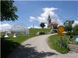
Šmarna gora is a 669 m high peak located north-west of Slovenia's capital. From the summit, which has a restaurant and a church, there is a beaut...
1 h 30 min |
 | Povodje - Šmarna gora (via Sedlo)
Šmarna gora is a 669 m high peak located north-west of Slovenia's capital. From the summit, which has a restaurant and a church, there is a beaut...
1 h 35 min |
| Šmartno - Šmarna gora (path around Šmarna gora)
Šmarna gora is a 669 m high peak located north-west of Slovenia's capital. From the summit, which has a restaurant and a church, there is a beaut...
1 h 30 min |
 | Vikrče - Šmarna gora (via Zatrep)
Šmarna gora is a 669 m high peak located north-west of Slovenia's capital. From the summit, which has a restaurant and a church, there is a beaut...
1 h 10 min |
 | Povodje - Šmarna gora (Partizanska steza)
Šmarna gora is a 669 m high peak located north-west of Slovenia's capital. From the summit, which has a restaurant and a church, there is a beaut...
1 h 45 min |
| Skaručna - Šmarna gora
Šmarna gora is a 669 m high peak located north-west of Slovenia's capital. From the summit, which has a restaurant and a church, there is a beaut...
1 h 30 min |
| Skaručna - Šmarna gora (via Sedlo)
Šmarna gora is a 669 m high peak located north-west of Slovenia's capital. From the summit, which has a restaurant and a church, there is a beaut...
1 h 35 min |
| Skaručna - Šmarna gora (Partizanska steza)
Šmarna gora is a 669 m high peak located north-west of Slovenia's capital. From the summit, which has a restaurant and a church, there is a beaut...
1 h 45 min |
| Vikrče - Šmarna gora (Mazijeva steza)
Šmarna gora is a 669 m high peak located north-west of Slovenia's capital. From the summit, which has a restaurant and a church, there is a beaut...
1 h 35 min |
 | Lipa - Šmarna gora (by road)
Šmarna gora is a 669 m high peak located north-west of Slovenia's capital. From the summit, which has a restaurant and a church, there is a beaut...
1 h 5 min |
 | Vikrče - Šmarna gora (Kovačeva steza)
Šmarna gora is a 669 m high peak located north-west of Slovenia's capital. From the summit, which has a restaurant and a church, there is a beaut...
1 h 10 min |
| Vikrče - Šmarna gora (learning trail)
Šmarna gora is a 669 m high peak located north-west of Slovenia's capital. From the summit, which has a restaurant and a church, there is a beaut...
1 h 20 min |
| Spodnje Pirniče - Šmarna gora (Kovačeva steza)
Šmarna gora is a 669 m high peak located north-west of Slovenia's capital. From the summit, which has a restaurant and a church, there is a beaut...
1 h 10 min |
| Spodnje Pirniče - Šmarna gora (learning trail)
Šmarna gora is a 669 m high peak located north-west of Slovenia's capital. From the summit, which has a restaurant and a church, there is a beaut...
1 h 10 min |
 | Povodje - Rašica (Vrh Staneta Kosca)
Vrh Staneta Kosca, better known as Rašica, is located north of Ljubljana, specifically above the villages of Rašica and Dobeno. From the top of t...
1 h 30 min |
 | Jablje Castle - Rašica (Vrh Staneta Kosca)
Vrh Staneta Kosca, better known as Rašica, is located north of Ljubljana, specifically above the villages of Rašica and Dobeno. From the top of t...
1 h 20 min |
| Loka - Rašica (Vrh Staneta Kosca)
Vrh Staneta Kosca, better known as Rašica, is located north of Ljubljana, specifically above the villages of Rašica and Dobeno. From the top of t...
1 h 20 min |
 | Selo pri Vodicah - Rašica (Vrh Staneta Kosca) (old path)
Vrh Staneta Kosca, better known as Rašica, is located north of Ljubljana, specifically above the villages of Rašica and Dobeno. From the top of t...
1 h 15 min |
 | Selo pri Vodicah - Rašica (Vrh Staneta Kosca) (by road)
Vrh Staneta Kosca, better known as Rašica, is located north of Ljubljana, specifically above the villages of Rašica and Dobeno. From the top of t...
1 h 20 min |
 | Selo pri Vodicah - Rašica (Vrh Staneta Kosca)
Vrh Staneta Kosca, better known as Rašica, is located north of Ljubljana, specifically above the villages of Rašica and Dobeno. From the top of t...
1 h 30 min |
 | Ljubljana (Šentvid) - Toško Čelo
Toško Čelo is a 590 m high hill above the village of the same name. From the top, or slightly lower down, you have a beautiful view of part of Lj...
1 h 45 min |
 | Gabrje - Jeterbenk
Jeterbenk is a 774 m high peak located between Slavko's home at Gole Brdo and Katarina (Topol village). From the top, where there is a large cros...
1 h 30 min |
 | Horjul - Koreno (gentle path)
Koreno also Koreno is a 729 m high hill located north of Horjul. From the top, where there is a large cross, the Church of St. Mohorj and Fortuna...
1 h 5 min |
 | Polhov Gradec - Koreno
Koreno also Koreno is a 729 m high hill located north of Horjul. From the top, where there is a large cross, the Church of St. Mohorj and Fortuna...
1 h 45 min |
 | Zaklanec - Koreno
Koreno also Koreno is a 729 m high hill located north of Horjul. From the top, where there is a large cross, the Church of St. Mohorj and Fortuna...
1 h 15 min |
 | Srednja vas - Koreno
Koreno also Koreno is a 729 m high hill located north of Horjul. From the top, where there is a large cross, the Church of St. Mohorj and Fortuna...
1 h 20 min |
 | Sora - Hom (by road)
Hom is a 715 m high peak rising steeply south-west of the village of Sora. The summit, which is partly covered with forest, offers a beautiful vi...
1 h 5 min |
 | Povodje - Grmada
Grmada is a 676 m high mountain located to the west of the much more visited Šmarna Gora. From the top, where there is a small airstrip, we have ...
1 h 50 min |
| Vikrče - Grmada (via Zatrep)
Grmada is a 676 m high mountain located to the west of the much more visited Šmarna Gora. From the top, where there is a small airstrip, we have ...
1 h 15 min |
| Skaručna - Grmada
Grmada is a 676 m high mountain located to the west of the much more visited Šmarna Gora. From the top, where there is a small airstrip, we have ...
1 h 50 min |
 | Vikrče - Grmada (Mazijeva steza)
Grmada is a 676 m high mountain located to the west of the much more visited Šmarna Gora. From the top, where there is a small airstrip, we have ...
1 h 5 min |
| Tacen - Grmada (Mazijeva steza)
Grmada is a 676 m high mountain located to the west of the much more visited Šmarna Gora. From the top, where there is a small airstrip, we have ...
1 h 10 min |
| Tacen (Sveti Jurij) - Grmada
Grmada is a 676 m high mountain located to the west of the much more visited Šmarna Gora. From the top, where there is a small airstrip, we have ...
1 h 5 min |
 | Vikrče - Grmada (Kovačeva steza)
Grmada is a 676 m high mountain located to the west of the much more visited Šmarna Gora. From the top, where there is a small airstrip, we have ...
1 h 10 min |
 | Lipa - Grmada (by road)
Grmada is a 676 m high mountain located to the west of the much more visited Šmarna Gora. From the top, where there is a small airstrip, we have ...
1 h 10 min |
| Vikrče - Grmada (on Kovačeva steza and over Sedlo)
Grmada is a 676 m high mountain located to the west of the much more visited Šmarna Gora. From the top, where there is a small airstrip, we have ...
1 h 15 min |
| Vikrče - Grmada (learning trail)
Grmada is a 676 m high mountain located to the west of the much more visited Šmarna Gora. From the top, where there is a small airstrip, we have ...
1 h 20 min |
| Spodnje Pirniče - Grmada (learning trail)
Grmada is a 676 m high mountain located to the west of the much more visited Šmarna Gora. From the top, where there is a small airstrip, we have ...
1 h 15 min |
| Spodnje Pirniče - Grmada (on Kovačeva steza and over Sedlo)
Grmada is a 676 m high mountain located to the west of the much more visited Šmarna Gora. From the top, where there is a small airstrip, we have ...
1 h 15 min |
 | Krašnja - Limbarska gora
Limbarska gora is located north-east of Moravce. From the top there is a beautiful view of the surrounding peaks and in good weather you can also...
1 h 15 min |
| Lake Gradišče - Limbarska gora
Limbarska gora is located north-east of Moravce. From the top there is a beautiful view of the surrounding peaks and in good weather you can also...
1 h 55 min |
 | Za koridorjem - Sabotin (on ridge)
Sabotin is hill above Nova Gorica or more accurate above Solkan. Altough its low attitude it is great outlook with sight to Julian Alps, river So...
1 h 15 min |
 | Blatni dol - Koča na Planini nad Vrhniko
Planina above Vrhnika is for hers inhabitants something like Šmarna gora for inhabitants of Ljubljana. It is 733 metres high and is reachable fro...
1 h 10 min |
 | Vrhnika - Koča na Planini nad Vrhniko (via bukev)
Planina above Vrhnika is for hers inhabitants something like Šmarna gora for inhabitants of Ljubljana. It is 733 metres high and is reachable fro...
1 h 5 min |
 | Stara Vrhnika - Koča na Planini nad Vrhniko (via Kuren)
Planina above Vrhnika is for hers inhabitants something like Šmarna gora for inhabitants of Ljubljana. It is 733 metres high and is reachable fro...
1 h 15 min |
| Stara Vrhnika - Koča na Planini nad Vrhniko (via Špica)
Planina above Vrhnika is for hers inhabitants something like Šmarna gora for inhabitants of Ljubljana. It is 733 metres high and is reachable fro...
1 h 15 min |
 | Senožeti - Sveti Miklavž above Sava (footpath)
The Church of St Nicholas is situated on a hill south of Moravče. From the top you can enjoy a beautiful view of the nearby Limbarska gora, and t...
1 h 20 min |
 | Prevala - Škabrijel (via Veliki hrib)
Škabrijel is an peak north-east of the town of Gorizia. Since the vegetation has been cleared and a tall metal lookout tower erected at the top, ...
1 h 5 min |
 | Rečica ob Paki - Gora Oljka
Gora Oljka is a hill located east of Šmartno ob Paki. On the top stands the Church of the Holy Cross, which was built in the mid-18th century. Ju...
1 h 15 min |
 | Podgora - Gora Oljka (Martin way)
Gora Oljka is a hill located east of Šmartno ob Paki. On the top stands the Church of the Holy Cross, which was built in the mid-18th century. Ju...
1 h 20 min |
 | Podvin pri Polzeli - Gora Oljka (upper path)
Gora Oljka is a hill located east of Šmartno ob Paki. On the top stands the Church of the Holy Cross, which was built in the mid-18th century. Ju...
1 h 35 min |
| Podvin pri Polzeli - Gora Oljka (lower path)
Gora Oljka is a hill located east of Šmartno ob Paki. On the top stands the Church of the Holy Cross, which was built in the mid-18th century. Ju...
1 h 30 min |
 | Zabukovica - Kotečnik
Kotečnik is a peak in Posavsko hribovje, located north of Šmohor. Kotečnik is a peak with two entry boxes. The first one is located on the wester...
1 h 30 min |
 | Griže - Dragov dom na Homu (direct path)
Drago's home is located on a scenic hill, south of Šempeter. From the top, which is also the Church of St. Magdalene, there is a beautiful view f...
1 h 30 min |
| Griže - Dragov dom na Homu (via Zahom)
Drago's home is located on a scenic hill, south of Šempeter. From the top, which is also the Church of St. Magdalene, there is a beautiful view f...
1 h 50 min |
| Griže - Dragov dom na Homu (via Lajnarjev hrib)
Drago's home is located on a scenic hill, south of Šempeter. From the top, which is also the Church of St. Magdalene, there is a beautiful view f...
1 h 40 min |
| Šešče pri Preboldu - Dragov dom na Homu (Brdovska pot)
Drago's home is located on a scenic hill, south of Šempeter. From the top, which is also the Church of St. Magdalene, there is a beautiful view f...
1 h 15 min |
 | Šentjur - Resevna
Resevna is a peak located south of Šentjur. On the top is a 20m high lookout tower, which gives us a beautiful view of almost the whole of Sloven...
1 h 30 min |
| Jakob pri Šentjurju - Resevna
Resevna is a peak located south of Šentjur. On the top is a 20m high lookout tower, which gives us a beautiful view of almost the whole of Sloven...
1 h 30 min |
 | Šentjur (center) - Resevna (via Krajnče)
Resevna is a peak located south of Šentjur. On the top is a 20m high lookout tower, which gives us a beautiful view of almost the whole of Sloven...
1 h 35 min |
| Šentjur (center) - Resevna (steep path)
Resevna is a peak located south of Šentjur. On the top is a 20m high lookout tower, which gives us a beautiful view of almost the whole of Sloven...
1 h 30 min |
| Šentjur (center) - Resevna (gentle path)
Resevna is a peak located south of Šentjur. On the top is a 20m high lookout tower, which gives us a beautiful view of almost the whole of Sloven...
1 h 35 min |
 | Gorica pri Slivnici - Rifnik
Rifnik is a 568m high peak located south of Šentjur near Celje. The summit, which is famous for its archaeological site, offers a beautiful view ...
1 h 15 min |
 | Zvodno - Grmada above Celje (via Suhi potok)
What Šmarna Gora is to the inhabitants of Ljubljana, Grmada is to the inhabitants of Celjá. The hut mountain of Celje is located south of the tow...
1 h 15 min |
 | Zvodno - Srebotnik (on Celje mountain trail)
Srebotnik is a lightly vegetated peak located south of Celje and Štore in the Posavje Hills. From the top, which has a registration box and a sma...
1 h 15 min |
 | Slovenske Konjice - Skala (gentle path)
Skala is a viewpoint on the eastern part of Konjiška Gora. From the viewpoint, which has a table, bench and a registration box, there is a beauti...
1 h 30 min |
 | Lopata - Planinski dom Šentjungert
The mountain lodge is located just a few metres below the top of Gora, on which the Church of St Kunigunde, built in the 14th century, stands. Th...
1 h 30 min |
 | Bresternica (Šoberjev dvor) - Tojzlov vrh
Tojzlov vrh is a forested hill located in the eastern part of Kozjak. On the top of the hill stands a small stone monument to the National Libera...
1 h 15 min |
 | Kamnica - Murovica
Murovica is a popular excursion point, accessible from the Posavina side, Domžale or from the Moravška valley. There is a bench and a registratio...
1 h 20 min |
 | Pristavlja vas - Pristava above Stična
Pristava above Stična is a small village located on a scenic hill north of Stična. A little above the village, by the Partisan House, there is a ...
1 h 45 min |
 | Pristavlja vas - Sveti Lambert
Sveti Lambert is located on an inconspicuous peak near the village of Pristava above Stično. From the top of the hill, where the castle of the Du...
1 h 45 min |
 | Polhov Gradec - Visoki hrib
Visoki hrib is a 602 m high hill located south of Polhov Gradec. The summit, partly covered by forest, offers a beautiful view, especially to the...
1 h 15 min |
 | Preska - Sveti Florijan (Tehovec)
The Church of St Florian is a branch church located in the village Tehovec above Medvode. The church, which was first mentioned in 1548, offers a...
1 h 15 min |
| Sora - Sveti Florijan (Tehovec)
The Church of St Florian is a branch church located in the village Tehovec above Medvode. The church, which was first mentioned in 1548, offers a...
1 h 15 min |
 | Pliskovica - Volnik
Volnik or Monte Lanaro in Italian is a 546 m high hill located near the village of Pliskovica in the Karst. It is topped by a small tower and off...
1 h 30 min |
 | Reka - Rodne
Rodne is a 698 m high peak located west of Orehovška Grape. From the top, which is covered with grass, we have a beautiful view towards the Cerkl...
1 h 20 min |
 | Divje jezero - Zagrebenc
Zagrebenc on some maps also Čekovnik is a 763 m high peak located between Hleviška planina and the valley of the Idrijca River. The grassy peak, ...
1 h 30 min |
 | Seljanec - Ham (via Seljanečki potok)
Ham is a lonely peak in the Ivanščice mountains, above the Bednje valley. It is separated from Ivanščice by the valley of the Železnice stream, a...
1 h 30 min |
 | Dobrnič - Trebni vrh (via Šahovec)
Trebni vrh is a 581-metre-high hill located south or south-west of Trebnje. On the top of the forested hill there is a bench, and near it there i...
1 h 45 min |
 | Brezje pri Dobrovi - Vrh (Debeli hrib) (via Strmca)
The summit is a 540 m high hill located on the Debeli hrib ridge, a ridge situated between the Ljubljana Marshes and the Horjulščice River valley...
1 h 15 min |
 | Kozje - Raskože (Bohor) (via Vetrnik)
Raskože is a 650-metre-high peak in the eastern part of Bohor. Some also call this area Vetrnik. The south side of the peak is dominated by fores...
1 h 15 min |
 | Zagrad - Vipota (via crossing Ivankovič)
Vipota is a 532-metre-high peak south of Celje, above the left bank of the Savinja. Approaches to the summit are possible from several directions...
1 h 15 min |
| Tourist farm Žurej - Žusem (Panoramska pot - old route)
Žusem is a 669-metre-high hill with a colourful history and great potential for the future. It represents the northern edge of the Kozjansko regi...
1 h 40 min |
 | Tourist farm Žurej - Žusem (Panoramska pot)
Žusem is a 669-metre-high hill with a colourful history and great potential for the future. It represents the northern edge of the Kozjansko regi...
1 h 40 min |
 | Loka pri Žusmu (Žamerk) - Žusem
Žusem is a 669-metre-high hill with a colourful history and great potential for the future. It represents the northern edge of the Kozjansko regi...
1 h 20 min |
 | Loka pri Žusmu (Žamerk) - Žusem (via Dobrina)
Žusem is a 669-metre-high hill with a colourful history and great potential for the future. It represents the northern edge of the Kozjansko regi...
1 h 30 min |
| Krka - Ciganov vrh (Korinjski hrib) (part of circular path Prijetno domače)
Ciganov vrh or Korinjski hill is a small hill rising above the valley of the river Krka, from which we have a view of the rather woded surroundin...
1 h 45 min |
 | Rdeči Kal - Ostri vrh (above Globodol) (via Velika raven)
Ostri vrh is a 523 m high peak located between Vrbovec, Rdeči Kal, Gorenji, Sredni and Dolenji Globodol, Dolni and Gorni Ajdovec and Podlipa. The...
1 h 15 min |
 | Okrog (Lazar) - Zaplaz
Zaplaz is a 543-metre-high hill located above Čatež, a village known mainly for the destination of the Levstik Trail (From Litija to Čatež). On t...
1 h 10 min |
 | Bridge over Dušica - Bajturn (Zaplaški hrib) (on ridge)
At 609 metres, Bajturn or Zaplaz Hill is the highest peak in the municipality of Trebnje. At the top there is a nice bench with a table, a box wi...
1 h 20 min |
| Bridge over Dušica - Bajturn (Zaplaški hrib) (on north slope)
At 609 metres, Bajturn or Zaplaz Hill is the highest peak in the municipality of Trebnje. At the top there is a nice bench with a table, a box wi...
1 h 30 min |
| Okrog (Lazar) - Bajturn (Zaplaški hrib) (on ridge)
At 609 metres, Bajturn or Zaplaz Hill is the highest peak in the municipality of Trebnje. At the top there is a nice bench with a table, a box wi...
1 h 30 min |
| Okrog (Lazar) - Bajturn (Zaplaški hrib) (on north slope)
At 609 metres, Bajturn or Zaplaz Hill is the highest peak in the municipality of Trebnje. At the top there is a nice bench with a table, a box wi...
1 h 40 min |
 | Višnja Gora - Sveti Duh (Polževo)
The Church of the Holy Spirit is located 630 metres above sea level, on a hill above the Polževo Hotel. The stamp is located some 10 metres away,...
1 h 30 min |
 | Bad Gleichenberg (Sägewerk Weiss) - Stradner Kogel
Stradner Kogel is the highest hill in south-eastern Styria. The hill is of volcanic origin, and its vegetation prevents views in any direction. O...
1 h 15 min |
| Haag - Stradner Kogel
Stradner Kogel is the highest hill in south-eastern Styria. The hill is of volcanic origin, and its vegetation prevents views in any direction. O...
1 h 10 min |
 | Naraplje - Jelovice
Jelovice with a height of 623 metres - the highest peak of the Haloze hills. The summit is accessible from several directions. It is partially vi...
1 h 40 min |
| Stogovci (Vabča vas) - Jelovice
Jelovice with a height of 623 metres - the highest peak of the Haloze hills. The summit is accessible from several directions. It is partially vi...
1 h 40 min |
 | Gorjuša - Sveta Trojica (above Dob) (via Dobovlje)
Sveta Trojica is a village located southeast of Dob at Domžale, and the Church of the Holy Trinity stands on the upper part of the village, on a ...
1 h 50 min |
 | Zgornje Poljčane - Ljubična gora
Ljubična gora is a hill located above Ljubično, Zbelovo and Zbelovo Gora. The hill is hidden in the forest and is not very visible, but the churc...
1 h 15 min |
 | Puštal (Na Dobravi) - Sveti Andrej (above Zminec)
The Church of St Andrew is located on a hill overloking the village of Sv. The church offers a beautiful view of Škofjeloško and Polhograjsko hri...
1 h 15 min |
 | Zvodno - Bavč (via Suhi potok)
Bavč is a vegetated peak located south of Celje and Zvodno in Posavsko hribovje between Grmada and Srebotnik. On the way to the summit, we often ...
1 h 10 min |
 | Socka - Kozjek (above Socka)
Kozjek) is an interesting peak, lying west of the ridge-like Kislica as a kind of pointed extension with precipitous walls on its western side. I...
1 h 10 min |
 | Velika Kostrevnica - Kožljevec
Kožljevec (also Kožlevec) is a 533 m high hill above Cerovica in the municipality of Šmartno pri Litija. The top, which also has a box with a reg...
1 h 10 min |
 | Stogovci (Vabča vas) - Kerješetov vrh
Kerješetov vrh is a 590-metre-high hill located above Jelovice. The hill is covered with forest, and the view is second to none....
1 h 30 min |
 | Brezno - Sveti Jurij (Remšnik) (along Remšniški potok)
The Church of St George is situated on a lookout point in the settlement Remšnik, which is on the slopes of Kozjak. Opposite the church, next to ...
1 h 35 min |
 | Center Vintgar - Lookout point at Ančnikovo gradišče (via Bistriški vintgar)
The viewing platform is located close to Ančnik's hillfort. The platform offers a beautiful view. We can see the place Slovenska Bistrica and it...
1 h 30 min |
 | Bad Gleichenberg (Eichgraben Weg) - Gleichenberger Kogel (via Mühlsteinbruch)
The Gleichenberger Kogel is a 598-metre-high volcanic mountain located above Bad Gleichenberg in Styria, Austria....
1 h 10 min |
| Bad Gleichenberg (Eichgraben Weg) - Gleichenberger Kogel
The Gleichenberger Kogel is a 598-metre-high volcanic mountain located above Bad Gleichenberg in Styria, Austria....
1 h 5 min |
| Bad Gleichenberg (Eichgraben Weg) - Gleichenberger Kogel (via Steinriegel)
The Gleichenberger Kogel is a 598-metre-high volcanic mountain located above Bad Gleichenberg in Styria, Austria....
1 h 55 min |
 | Rimske Toplice - Stražnik (via Borovo)
...
1 h 20 min |
 | Vuzenica - Sveti Janez Krstnik (Šentjanž nad Dravčami)
...
1 h 25 min |
 | Vuzenica - Sveti Primož (Sveti Primož na Pohorju)
...
1 h 30 min |
 | Gorica pri Slivnici - Church of St. Helena on Javor
...
1 h 45 min |
 | Podčetrtek (Terme Olimia) - Zavetišče Šmarnica on Mala Rudnica (past castle Podčetrtek)
...
1 h 15 min |
| Podčetrtek (sveti Lovrenc) - Zavetišče Šmarnica on Mala Rudnica (past castle Podčetrtek)
...
1 h 5 min |
 | Olimje - Zavetišče Šmarnica on Mala Rudnica
...
1 h 45 min |
| Slake (Church of the Virgin Mary on Pesek) - Zavetišče Šmarnica on Mala Rudnica
...
1 h 35 min |
 | Podčetrtek (Terme Olimia) - Silavec (The Tower of Health and Joy on Rudnica) (past castle Podčetrtek)
...
1 h 35 min |
| Podčetrtek (sveti Lovrenc) - Silavec (The Tower of Health and Joy on Rudnica) (past castle Podčetrtek)
...
1 h 25 min |
| Podčetrtek (sveti Lovrenc) - Silavec (The Tower of Health and Joy on Rudnica) (easier path)
...
1 h 15 min |
| Podčetrtek (sveti Lovrenc) - Silavec (The Tower of Health and Joy on Rudnica) (harder path)
...
1 h 15 min |
| Spodnje Tinsko - Silavec (The Tower of Health and Joy on Rudnica)
...
1 h 20 min |
| Olimje - Silavec (The Tower of Health and Joy on Rudnica) (past Koča pri čarovnici)
...
1 h 45 min |
| Olimje - Silavec (The Tower of Health and Joy on Rudnica) (harder path)
...
1 h 35 min |
| Olimje - Silavec (The Tower of Health and Joy on Rudnica) (easier path)
...
1 h 35 min |
| Slake (Church of the Virgin Mary on Pesek) - Silavec (The Tower of Health and Joy on Rudnica) (harder path)
...
1 h 25 min |
| Slake (Church of the Virgin Mary on Pesek) - Silavec (The Tower of Health and Joy on Rudnica) (easier path)
...
1 h 25 min |
 | Žena Glava - Sveti Duh (Hum)
...
1 h 45 min |
 | Zgornje Poljčane - Rančka
...
1 h 25 min |
 | Olimje - Plešivec (Rudnica) (past lake Zmajevo jezero)
...
1 h 50 min |
| Olimje - Plešivec (Rudnica)
...
1 h 30 min |
 | Loka pri Žusmu (Hudi graben) - Plešivec (Rudnica)
...
1 h 40 min |
 | Prebold - Žvajga (northern peak) (western path)
...
1 h 5 min |
 | Rukavac - Orjak (above Opatija) (direct way)
...
1 h 30 min |
 | Liganj - Gorica (above Lovran)
...
1 h 10 min |
 | Stojdraga (Glažuta) - Tuščak (Žumberačka gora)
...
1 h 10 min |
 | Stojdraga (Glažuta) - Gradina Tuščak (via Tuščak)
...
1 h 20 min |
 | Jama Pekel (parkirišče) - Apno (čez Pogorišče)
...
1 h 25 min |