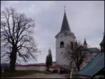
 | Topol - Sveti Jakob
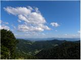
The Church of St. James is located on a scenic hill north of the village of Topol pri Medvodah. From the summit, which features a registration bo...
40 min |
| Topol - Sveti Jakob (via homestead Na Vihri)
The Church of St. James is located on a scenic hill north of the village of Topol pri Medvodah. From the summit, which features a registration bo...
45 min |
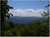
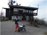 | Zamlake - Krim
Krim is a 1,107-metre-high mountain rising south of the Ljubljana Marsh. From the summit, where a mountain hut and several transmitters stand, th...
50 min |
 | Javornik - Sveti Jošt above Kranj
Sveti Jošt above Kranj is a hill located west of the slightly lower Šmarjetna gora. From the summit, where the Church of St Jošt stands alongside...
40 min |
 | Rovišče - Zasavska Sveta gora (by road)
Zasavska Sveta Gora is a popular excursion destination located between Litija and Izlake. From the summit, where the parish church of the Nativit...
35 min |
 | Križna Gora - Archangel Gabriel (Planica)
Planica is an 824-meter-high peak located north of Škofja Loka, more precisely between Križna gora and Planica. From the summit, where the church...
35 min |
 | Čepulje - Archangel Gabriel (Planica)
Planica is an 824-meter-high peak located north of Škofja Loka, more precisely between Križna gora and Planica. From the summit, where the church...
50 min |
 | Smrečje - Vrh Svetih Treh Kraljev (by road)
The Church of the Holy Three Kings stands on a panoramic hill above the village of Vrh Svetih Treh Kraljev. The summit features a panorama board ...
45 min |
 | Smrečje - Vrh Svetih Treh Kraljev (footpath)
The Church of the Holy Three Kings stands on a panoramic hill above the village of Vrh Svetih Treh Kraljev. The summit features a panorama board ...
40 min |
| Smrečje - Vrh Svetih Treh Kraljev (via Jereb)
The Church of the Holy Three Kings stands on a panoramic hill above the village of Vrh Svetih Treh Kraljev. The summit features a panorama board ...
45 min |
| Račevsko jezero - Vrh Svetih Treh Kraljev
The Church of the Holy Three Kings stands on a panoramic hill above the village of Vrh Svetih Treh Kraljev. The summit features a panorama board ...
45 min |
 | Zaplana (St. Urh and St. Martin) - Ulovka
Ulovka is a peak between Zaplana and Zavetišče na Planini nad Vrhniko. From the summit, to which ski lifts run, there is a nice view to the north...
50 min |
 | Travna Gora - Koča na Kamnem griču
The Koča na Kamnem griču mountain hut is located on Kamni grič, a panoramic hill rising southwest of Sodražica. From the grassy summit surrounded...
45 min |
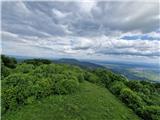
 | Velika vrata - Mala Plešivica
Mala Plešivica, higher than neighboring Velika Plešivica, is a panoramic peak located west of the village Golac near the Croatian border. On clea...
35 min |
 | Planinski dom Vrhe - Sveta planina (Partizanski vrh)
Sveta planina, also Partizanski vrh, is a 1,011-meter-high mountain located between Čemšeniška planina and Mrzlica. From the summit, where there ...
35 min |
 | Kamen - Mokrc
Mokrc (Mokrec on maps) is a 1,059-meter-high mountain located east of Iški Vintgar. The summit is forested and offers no views.For some views, it...
40 min |
 | Smrečje - Lavrovec
Lavrovec is an 890-meter-high peak located between Horjul and Žiri. From the summit, which hosts a solar irradiance meter (official measuring poi...
40 min |
 | Dom na Govejku - Gontarska planina
Gontarska Planina is a 894-meter-high hill located between Osolnik and Tošč. From the summit, which features two benches, a splendid view opens t...
35 min |
 | Belo - Goljek
Goljek is an 809 m high peak located east of Polhograjska Grmada. From the summit, where remains of a former guard tower on the Italian-German bo...
40 min |
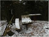
 | Mesnice - Rotovc
Rotovc is a 964-meter-high peak situated northeast of Rakitna. From the summit, where a wooden bench stands, a beautiful view opens up toward the...
55 min |
 | Brancljeva senožet - Rotovc
Rotovc is a 964-meter-high peak situated northeast of Rakitna. From the summit, where a wooden bench stands, a beautiful view opens up toward the...
45 min |
 | Čepulje - Špičasti hrib
Špičasti hrib (known as Špičasti vrh on maps) is an 837-meter-high hill located west of Sveti Jošt above Kranj. The summit, which has a few bench...
40 min |
 | Podlanišče - Veliki vrh (Lajše)
Veliki vrh is an almost 900-meter-high elevation rising south of Cerkno. From the summit, which features several television and radio transmitter...
40 min |
 | Hunting sports association Vinska Gora - Vinska gora
Vinska gora (marked as the neighboring Temnjak on some maps) is an 806 m high hill located northwest of Dobrna and northeast of Vinska Gora. From...
40 min |
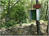
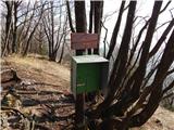
 | Solarji - Ježa
Ježa is a 949-meter-high peak located west of Volče, more precisely on the slopes of Kolovrat. From the summit, which has a logbook box with a bo...
45 min |
 | Planinski dom pod Ježo - Deveti konfin (survey point 930)
Deveti konfin at survey point 930 is located along the marked path leading from Planinski dom pod Ježo towards Očna. From the meadow a few meters...
55 min |
 | Planinski dom pod Ježo - Deveti konfin (survey point 942)
Deveti konfin at survey point 942 is one of two peaks of Deveti konfin in the Kolovrat range, located between Ježa and Očna. From the summit, whe...
45 min |
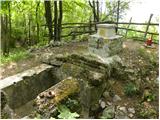 | Srednje - Globočak
Globočak is an 809 m high peak located in the Kanal Kolovrat range. From the summit, which has some remnants from the First World War, there is n...
35 min |
 | Črne njive - Ahac
Ahac (or Sv. Ahac) is a 799-meter-high peak located east of Ilirska Bistrica. The summit hosts a summit logbox, a cross, and ruins of the former ...
40 min |
 | Dragonoš (Krpesovka) - Japetić
Japetić is the highest peak of the Samoborsko gorje. It is located in its western part and serves as the local mountain for the town of Jastrebar...
45 min |
| Stružnica - Kuželjska stena
Kuželjska stena rises mightily above the village of Kuželj in the Kolpa River valley. It is a hill at a slope break, winding above the upper Kolp...
45 min |
 | Pohorje cable car - Ledinekov kogel
Ledinekov kogel is a 1,182-meter-high peak located north of Mariborska koča. Just below the summit there is a fenced area with a radar tower....
40 min |
 | Rašpor - Gradina Rašpor (on marked path)
Gradina Rašpor are the ruins of a former castle above the village of Rašpor. Several information boards are by the ruins. Due to the surrounding ...
45 min |