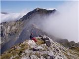
 | Urbas - Hochstuhl/Stol
Stol is, at 2236 m, the highest peak of the Karavanke. From the summit, which has a registration box and a stamp, we have a beautiful view of the...
3 h 15 min |
 | Planina Jezerca - Veliki Zvoh (on unmarked path via Razor)
Veliki Zvoh is the highest point of the Krvavec ski resort. The cable car does not quite reach the top, missing only a few metres. A few metres b...
2 h 15 min |
 | End of road on Pokljuka - Viševnik (via Gola Ravan)
Viševnik is a 2050 m high mountain rising northwest of Rudno polje on Pokljuka. From the summit, where the stamp is located, a beautiful view ope...
2 h 15 min |
| Rudno polje - Viševnik (via Gola Ravan)
Viševnik is a 2050 m high mountain rising northwest of Rudno polje on Pokljuka. From the summit, where the stamp is located, a beautiful view ope...
2 h 15 min |
 | End of road on Pokljuka - Viševnik (via source of Zlata voda)
Viševnik is a 2050 m high mountain rising northwest of Rudno polje on Pokljuka. From the summit, where the stamp is located, a beautiful view ope...
2 h 20 min |
| Rudno polje - Viševnik (via source of Zlata voda)
Viševnik is a 2050 m high mountain rising northwest of Rudno polje on Pokljuka. From the summit, where the stamp is located, a beautiful view ope...
2 h 20 min |
| Uskovnica (Razpotje) - Viševnik (via source of Zlata voda)
Viševnik is a 2050 m high mountain rising northwest of Rudno polje on Pokljuka. From the summit, where the stamp is located, a beautiful view ope...
2 h 55 min |
| Uskovnica (Lom) - Viševnik (via source of Zlata voda)
Viševnik is a 2050 m high mountain rising northwest of Rudno polje on Pokljuka. From the summit, where the stamp is located, a beautiful view ope...
3 h 15 min |
| Uskovnica (Lom) - Viševnik (via Gola Ravan)
Viševnik is a 2050 m high mountain rising northwest of Rudno polje on Pokljuka. From the summit, where the stamp is located, a beautiful view ope...
3 h 10 min |
| Uskovnica (Razpotje) - Viševnik (via Gola Ravan)
Viševnik is a 2050 m high mountain rising northwest of Rudno polje on Pokljuka. From the summit, where the stamp is located, a beautiful view ope...
2 h 50 min |
 | end of road on Pokljuka - Tosc
Tosc is located in the heart of the Julian Alps between Veliki Draški vrh and Mišelj vrh. The grassy peak offers a very nice view of Triglav and ...
3 h 25 min |
| Rudno polje - Tosc
Tosc is located in the heart of the Julian Alps between Veliki Draški vrh and Mišelj vrh. The grassy peak offers a very nice view of Triglav and ...
3 h 50 min |
 | Križovec - Barentaler Kotschna/Struška (footpath)
Barentaler Kotschna is a small mountain range located between Stolo or Belščica and Golica. From Veliki vrh, as the highest peak of the mountain ...
2 h 30 min |
| Križovec - Barentaler Kotschna/Struška (by road)
Barentaler Kotschna is a small mountain range located between Stolo or Belščica and Golica. From Veliki vrh, as the highest peak of the mountain ...
2 h 15 min |
 | Erjavčev rovt - Frauenkogel/Dovška Baba (direct way)
Frauenkogel is an 1891 m high peak located on the border ridge between Slovenia and Austria. The summit, which has a registration box and a stamp...
2 h 15 min |
 | Rogarjev rovt - Frauenkogel/Dovška Baba (via Rožca and Hruški vrh)
Frauenkogel is an 1891 m high peak located on the border ridge between Slovenia and Austria. The summit, which has a registration box and a stamp...
2 h 30 min |
 | End of road on Vogar - Slatna (via Griva)
Slatna is a scenic mountain located between Kredo and Prvi Vogel. The grassy peak, which is not reached by any marked trail, offers a beautiful v...
3 h 50 min |
 | Jezerski vrh - Plešivec
Plešivec is an 1801 m high peak located south of the eastern part of Košuta. The summit, on which the border signpost stands, offers a beautiful ...
3 h 30 min |
 | Razpotje Vragovec - Prešernova koča na Stolu (via Doslovška planina and hunting cottage)
Prešernova koča na Stolu, is located just a few metres below the summit of the 2198 m high Mali Stol. From the hut or the nearby Mali Stol, we ha...
2 h 55 min |
 | Javorje - Rodica (via Lepa Suha)
The mountain is located above Bohinj in the Lower Bohinj Mountains. From the top there is a beautiful view of Julian Alps and Škofjeloško and the...
2 h 30 min |
 | Planina Blato - Ogradi
Ogradi are located between mountain pasture Laz and mountain pasture Krstnica. The summit is grassy with plenty of space. A small cross stands on...
2 h 45 min |
| Planina Blato - Ogradi (via Planina Krstenica)
Ogradi are located between mountain pasture Laz and mountain pasture Krstnica. The summit is grassy with plenty of space. A small cross stands on...
3 h 15 min |
 | Rudno polje - Debeli vrh above Lipanca (via Zgornji Razor)
Debeli vrh is a 1962 m high mountain located in a ridge of mountains rising steeply above the Krma valley. From the top, where a stamp is attache...
2 h 15 min |
 | Ravne - Rosenkogel/Hruški vrh (via Dovška Baba)
Rosenkogel is a 1776 m high mountain located between Frauenkogel and the slightly less known Klek. From the top, where there is a small chapel de...
2 h 25 min |
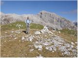
 | Urbas - Weinasch/Vajnež
Weinasch is the highest peak of Belščice, a mountain range located to the west of the better known Stoľa. From the top, where the cross and the S...
2 h 25 min |
| Olipova planina - Weinasch/Vajnež (via Hrašenska planina)
Weinasch is the highest peak of Belščice, a mountain range located to the west of the better known Stoľa. From the top, where the cross and the S...
2 h 50 min |
| Valvasorjev dom pod Stolom - Weinasch/Vajnež
Weinasch is the highest peak of Belščice, a mountain range located to the west of the better known Stoľa. From the top, where the cross and the S...
3 h 30 min |
 | Planina Ravne - Veliki vrh (Veža) (via Dleskovec)
Velika vrh is a 2110 m high mountain located in the central part of the Dleskovška plateau. From the top of the peak, where there are two registr...
2 h 45 min |
 | Javorje - Šija (via Kratki plaz)
The peak is located above the Vogel ski slope in the Lower Bohinj Mountains. From the top there is a beautiful view of the neighbouring peaks in ...
2 h 40 min |
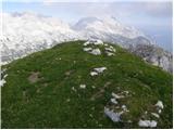
 | Urbas - Potoški Stol
Potoški Stol is located between Hochstuhl and Weinasch on the border with Austria. Just a few metres below the grassy peak, a cross is erected. T...
2 h 15 min |
| Olipova planina - Potoški Stol
Potoški Stol is located between Hochstuhl and Weinasch on the border with Austria. Just a few metres below the grassy peak, a cross is erected. T...
2 h 40 min |
 | Podnar / Bodenbauer - Ovčji vrh (Kozjak) / Geissberg (Kosiak) (via Karweg and southeast path)
Ovčji vrh or Kozjak, or Geissberg or Kosiak in German, is a 2024 m high peak located north of the main ridge of the Karavanke Mountains. The peak...
2 h 45 min |
| Podnar / Bodenbauer - Ovčji vrh (Kozjak) / Geissberg (Kosiak) (via Karweg and southwest path)
Ovčji vrh or Kozjak, or Geissberg or Kosiak in German, is a 2024 m high peak located north of the main ridge of the Karavanke Mountains. The peak...
3 h |
 | Tonnerhütte - Zirbitzkogel (winter path)
At 2396m, Zirbitzkogel is the highest peak in the Seetaler Alps. The summit, on which stands a cross and a viewing platform, offers a beautiful v...
2 h 27 min |
 | Tonnerhütte - Scharfes Eck (winter path)
Scharfes Eck is the peak on which the Austrian meteorological radar station stands. The unpopular peak offers a beautiful view of the neighbourin...
2 h 45 min |
 | Rudnik v Topli - Petzen (Kordeschkopf) (Peca (Kordeževa glava)) (via Knipsovo sedlo)
Kordeževa glava, better known as Peca is the highest summit in the mountain chain Peca. It is located on the border with Austria above Mežiška do...
2 h 45 min |
 | Planina Kuk - Žabiški Kuk (via planina Razor)
Žabiški Kuk is located on the southern side ridge of the Lower Bohinj Mountains near the better known Vogel and above mountain pasture Razor. Fro...
3 h |
 | Planina Kuk - Vrh Planje (above Globoko)
Vrh Planje is a less distinct peak in the ridge of the Lower Bohinj Mountains, which has recently become more and more visited. Vrh Planje (above...
2 h 45 min |
 | Planina Ravne - Velika Zelenica (via Dleskovec)
Velika Zelenica is the highest peak of the Dleskovská Plateau and the view is accordingly. The most beautiful is the nearby Ojstrica, below which...
2 h 45 min |
 | Pecol - Cima di Terrarossa
Cima di Terrarossa is a scenic peak located between Jôf di Montasio and Viš. From the summit, which is often full of ibex, you can admire the hig...
2 h 45 min |
 | Javorje - Raskovec (via Rodica)
Raskovec is a scenic mountain located between the better known Rodica and the Black Earth. From this little-visited peak, which has no registrati...
3 h 45 min |
| Rutarski gozd - Raskovec (via Rodica)
Raskovec is a scenic mountain located between the better known Rodica and the Black Earth. From this little-visited peak, which has no registrati...
3 h 30 min |
 | Rudnik v Topli - Končnikov vrh (Peca)
Končnikov vrh is a 2109 m high mountain located in the central part of Pec. The grassy peak offers a beautiful view along the Pec ridge and the m...
2 h 30 min |
 | Rudnik v Topli - Velika glava (Peca)
Velika glava is a peak in the Peć mountain range, located between Petzen and Končnik's Peak. The summit, which borders Austria, offers a beautifu...
2 h 30 min |
| Koprivna (Kumer) - Velika glava (Peca) (via Knipsovo sedlo)
Velika glava is a peak in the Peć mountain range, located between Petzen and Končnik's Peak. The summit, which borders Austria, offers a beautifu...
3 h 10 min |
 | Mangartska planina - Šober / Monte Sciober Grande (via Dren)
Šober is a 1845 m high peak located between Remšendol and the Jezersko Valley. From the top you can enjoy a beautiful view of the nearby Rabeljsk...
2 h 35 min |
 | Untere Wolayeralm - Mahderkopf (via Wolayerseehütte)
Mahderkopf is a 2155 m high mountain located north of the main chain of the Carnic Alps. From the grassy summit, you have a beautiful view of the...
3 h 45 min |
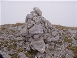
 | Planina Blato - Krsteniški Stog (čez Krsteniški preval)
Krsteniški or Little Stog is a 1879 m high mountain rising steeply above mountain pasture Krstenica. From the top, on which stands a stone cairn,...
2 h 25 min |
 | Vrh Bače - Rušni vrh
Rušni vrh is a 1786 m high peak located to the east of Črna prsti. From the summit, which is the boundary stone of the old Rapallo border, we hav...
3 h |
 | Šajda / Schaidasattel - Kravji vrh / Kuhberg (via Obirsko sedlo)
Kravji vrh is a two-thousand-metre peak on the Obir, with two peaks of approximately the same height. There is nothing on the higher one except d...
2 h 45 min |
 | Šajda / Schaidasattel - Kravji vrh / Kuhberg (steep path)
Kravji vrh is a two-thousand-metre peak on the Obir, with two peaks of approximately the same height. There is nothing on the higher one except d...
2 h 30 min |
 | Knödelhütte - Peterer Riegel (by grazing fence)
...
3 h 45 min |
 | Knödelhütte - Peterer Riegel (via Peterer Alm)
...
3 h 50 min |
| Unterauerlinger Hütte - Peterer Riegel (by grazing fence)
...
3 h 35 min |
| Unterauerlinger Hütte - Peterer Riegel (via Peterer Alm)
...
3 h 40 min |
 | Alpengasthof Scheikl - Hohe Veitsch (up along the southern ridge)
...
2 h 35 min |