Javorje - Šija (via Kratki plaz)
Starting point: Javorje (1050 m)
| Lat/Lon: | 46,2496°N 13,8675°E |
| |
Name of path: via Kratki plaz
Time of walking: 2 h 40 min
Difficulty: easy unmarked way
Altitude difference: 830 m
Altitude difference po putu: 830 m
Map: TNP 1:50.000
Recommended equipment (summer):
Recommended equipment (winter): ice axe, crampons
Views: 5.433
 | 1 person likes this post |
Access to the starting point:
From the Ljubljana - Jesenice motorway, take the Lesce exit and follow the road towards Bled and on to Bohinjska Bistrica and Lake Bohinj. After Laški Rovt you will reach a small crossroads where the road to the left branches off and leads to the starting points of the route to Rodica, mountain pasture Suho, Šijo, Vogel. . . and the Laški Rovt camping area. The dirt road immediately turns into a forest and first climbs past the above-mentioned camping area and then climbs relatively steeply for a few kilometres. After a little less than 6,5 km of macadam, you will reach a slightly larger crossroads where the road to the right branches off towards mountain pasture Storeča raven (the starting point of the route to Vogel). Continue straight on here and after about 50 m of further driving you will reach a left turn where the starting point of the route towards mountain pasture Suha. Park in a suitable place on the roadside.
Path description:
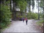
Near the parking lot, on the west side of the torrent, there is a marked footpath leading to mountain pasture Suha. The path initially climbs up the right-hand side of the torrent before joining it. After a few steps along the torrent, the marked path turns to the right and lays completely flat. The gently sloping walk is quickly interrupted by a steep ascent over a relatively steep slope. The steepness then eases a little and the well-marked path then leads up through the dense forest along and along the torrent. A little higher up, the marked path leaves the stream to the left and rejoins it after a few minutes. The path then runs along the right side of the torrent and soon leads us out of the forest onto the vast mountain pasture of Suha.
After the first hut on mountain pasture, you will see the Vogel markers on the right. Follow these signs and they will lead you to a badly worn path. Follow it upwards, first over a bit of grass, and then the path goes between dwarf pines. The path is marked at the beginning, then slowly the path disappears and then the markings. The path has not been marked for several years so that even those markings are difficult to see. When the track runs out, follow the transitions between dwarf pines, which are sometimes difficult to find. Here and there we see tracks but only for a short time. After about one hour from mountain pasture, the trail leads to the saddle between Zavitar (right) and the top of the cable car on the Vogel (left).
Here, head left towards the top of the cable car (lift) that you can see. The trackless trail ends here. Take the cart track, which leads you in a gentle downhill to the ski slope below the single-seater on Visoki Orlov rob. Here we climb to the top of the single-seater Visoki Orlov rob, where we also get on the marked path (the orientation is easier further on). Next, we walk along the path which descends slightly from Orlove glave and leads us to the foot of the Šija. The path then climbs slightly again and leads us to a crossroads where we continue straight ahead for the route Šija (left Rodica, right Vogel). The way ahead becomes quite steep and within five minutes of walking along the top slope leads us to a grassy peak.
Orientation between mountain pasture Suha and the cable cars on the Vogel is very difficult, so I advise against climbing in fog.
Starting point - mountain pasture Suha 1:00, mountain pasture Suha - Šija 1:40.

We can extend the trip to the following destinations: Vrh Dlani
Pictures:
 1
1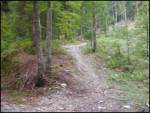 2
2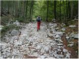 3
3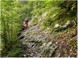 4
4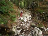 5
5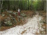 6
6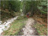 7
7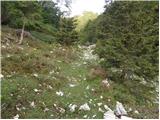 8
8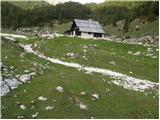 9
9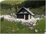 10
10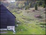 11
11 12
12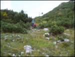 13
13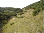 14
14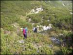 15
15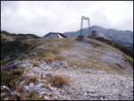 16
16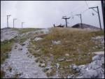 17
17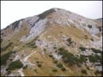 18
18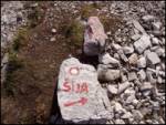 19
19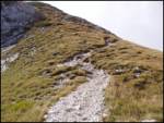 20
20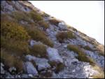 21
21 22
22
Discussion about the trail Javorje - Šija (via Kratki plaz)