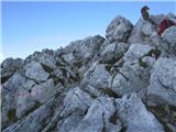
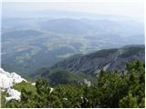
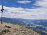
 | Dolina Krma - Begunjski vrh
Begunjski vrh is a 2461 m high mountain located in the heart of the highest mountains in the Julian Alps. From the top, which has a registration ...
5 h 45 min |
 | Dom v Dragi - Begunjščica (via Roblekov dom)
Begunjščica is a mountain range in the Karavanke east of Stol. The highest peak is Veliki vrh, which at over 2000 m offers a beautiful view of ce...
4 h 20 min |
 | Dom Trilobit - Hochstuhl/Stol (via Rida (Medji dol))
Stol is, at 2236 m, the highest peak of the Karavanke. From the summit, which has a registration box and a stamp, we have a beautiful view of the...
4 h 30 min |
 | Poljana (Završnica) - Hochstuhl/Stol (Žirovniška pot)
Stol is, at 2236 m, the highest peak of the Karavanke. From the summit, which has a registration box and a stamp, we have a beautiful view of the...
4 h 20 min |
 | Poljana (Završnica) - Hochstuhl/Stol (Zabreška pot)
Stol is, at 2236 m, the highest peak of the Karavanke. From the summit, which has a registration box and a stamp, we have a beautiful view of the...
4 h 40 min |
 | Podljubelj - Veliki vrh (Košuta) (via Matizovec)
Veliki vrh, with a height of 2088 m, is the westernmost two-thousander in the longest Slovenian ridge Košuta. From the summit, where there is a ...
4 h 15 min |
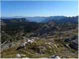
 | Krnica - Debela peč
Debela peč is a 2014 m high mountain that rises steeply above the Krma valley on one side and descends gently towards the vast Pokljuka forests o...
5 h 30 min |
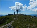
 | Laško - Storžič (via Javornik)
Storžič is a 2132 m high mountain located in the western part of the Kamnik-Savinja Alps. From the summit, where there is a cross, there is a bea...
4 h 10 min |
 | Povlje - Storžič (through southwest groove)
Storžič is a 2132 m high mountain located in the western part of the Kamnik-Savinja Alps. From the summit, where there is a cross, there is a bea...
4 h |
| Zalog - Storžič (below Psica and through southwest groove)
Storžič is a 2132 m high mountain located in the western part of the Kamnik-Savinja Alps. From the summit, where there is a cross, there is a bea...
4 h 35 min |
| Zalog - Storžič (via Planina Javornik and through southwest groove)
Storžič is a 2132 m high mountain located in the western part of the Kamnik-Savinja Alps. From the summit, where there is a cross, there is a bea...
4 h 30 min |
 | Petrovo Brdo - Črna prst
On the northern slope of the summit of Črna prst, one can observe the black soil from which the mountain takes its name. Črna prst is known for i...
4 h 40 min |
 | Dom v Lepeni - Krn
At 2244 m, Krn is the highest peak of the Krn Mountains, a mountain range that rises steeply above the central part of the Soča River. From the s...
5 h |
| Planina Kuhinja - Krn (via Krnska škrbina)
At 2244 m, Krn is the highest peak of the Krn Mountains, a mountain range that rises steeply above the central part of the Soča River. From the s...
3 h 30 min |
| Tolminske Ravne - Tolminski Kuk (via Planina Kal)
Tolminski Kuk is the highest peak of the Lower Bohinj Mountains. The summit, which has a registration box, offers a very nice view. From the top ...
4 h |
 | Zadnjica - Pogačnikov dom na Kriških podih
The hut is located on a panoramic hill in the Kriški Podi above Trenta. The hut, which is open in the summer season, also has a large winter room...
4 h |
 | Zadnjica - Zasavska koča na Prehodavcih
Zasavska koča na Prehodavcih is located on a scenic peak above the Triglav Lakes Valley. The hut, which is open in the summer season, offers a be...
4 h 15 min |
| Trenta - Zasavska koča na Prehodavcih
Zasavska koča na Prehodavcih is located on a scenic peak above the Triglav Lakes Valley. The hut, which is open in the summer season, offers a be...
4 h 15 min |
 | Mače - Srednji vrh (via Kozjek and Dolga njiva)
Srednji vrh is an 1853 m high mountain located to the east of Storžič. From the top, where there is a bench, a registration box and a stamp, we h...
3 h 30 min |
| Mače - Srednji vrh (Mačenska pot and via Cjanovca)
Srednji vrh is an 1853 m high mountain located to the east of Storžič. From the top, where there is a bench, a registration box and a stamp, we h...
3 h 50 min |
| Mače - Srednji vrh (Mačenska pot and via Dolga njiva)
Srednji vrh is an 1853 m high mountain located to the east of Storžič. From the top, where there is a bench, a registration box and a stamp, we h...
3 h 35 min |
| Mače - Srednji vrh (via Kozjek and Cjanovca)
Srednji vrh is an 1853 m high mountain located to the east of Storžič. From the top, where there is a bench, a registration box and a stamp, we h...
4 h |
 | Stara Fužina - Pršivec (Direct way)
Lookout Mountain is located above Lake Bohinj. The view is extensive on all sides. Triglav and the mountains around it can be seen, and on the ot...
3 h 45 min |
 | Mače - Bašeljski vrh (via Kozjek)
Bašeljski vrh is a 1744 m high mountain located between Mali Grintovec and Storžič. From the top, where there is a bench and a registration box w...
3 h 30 min |
 | Poljana (Završnica) - Prešernova koča na Stolu (Žirovniška pot)
Prešernova koča na Stolu, is located just a few metres below the summit of the 2198 m high Mali Stol. From the hut or the nearby Mali Stol, we ha...
4 h 5 min |
 | Poljana (Završnica) - Prešernova koča na Stolu (Zabreška pot)
Prešernova koča na Stolu, is located just a few metres below the summit of the 2198 m high Mali Stol. From the hut or the nearby Mali Stol, we ha...
4 h 25 min |
 | Grant - Rodica
The mountain is located above Bohinj in the Lower Bohinj Mountains. From the top there is a beautiful view of Julian Alps and Škofjeloško and the...
3 h 30 min |
| Stržišče - Rodica
The mountain is located above Bohinj in the Lower Bohinj Mountains. From the top there is a beautiful view of Julian Alps and Škofjeloško and the...
4 h 15 min |
 | Markova raven - Kalški greben (on marked path)
Kalški greben is 2224 m high and is the highest peak of the eponymous ridge. The summit, which has a registration box and a stamp, offers a beaut...
4 h 30 min |
 | Markova raven - Mokrica (marked way)
Mokrica is a scenic peak to the east of Kompotele. On the top, which is partly covered with dwarf pines, there is a registration book....
3 h 30 min |
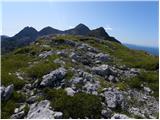
 | The Krma Valley - Visoka Vrbanova špica
Visoka Vrbanova špica, is located at the extreme south-western part of the ridge rising above the Kot and Vrata valleys, and higher up between th...
5 h 35 min |
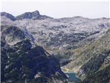
 | Koča pri Savici - Lanževica (via Bogatinsko sedlo)
Lanževica is a 2003 m high peak located between Bogatinsko sedlo and Oslovo Stub. The summit, on which the remains of the former Rapallo border s...
5 h |
| Koča pri Savici - Lanževica (via Lepa Komna)
Lanževica is a 2003 m high peak located between Bogatinsko sedlo and Oslovo Stub. The summit, on which the remains of the former Rapallo border s...
5 h |
 | Pod Zjabci - Lanževica (via Lepa Komna)
Lanževica is a 2003 m high peak located between Bogatinsko sedlo and Oslovo Stub. The summit, on which the remains of the former Rapallo border s...
5 h |
| Dom v Lepeni - Lanževica (via Bogatinsko sedlo)
Lanževica is a 2003 m high peak located between Bogatinsko sedlo and Oslovo Stub. The summit, on which the remains of the former Rapallo border s...
5 h |
 | Koča pri Savici - Mahavšček (via planina Govnjač)
Mahavšček or Big Bogatin is a 2008 m high mountain located on the north-western outskirts of the Lower Bohinj Mountains. From the top, where ther...
4 h 55 min |
 | Mojstrana - Sleme
The mountain is located between Mojstrana and Kukova Spica. The top is grassy and has a very nice view towards Kukova Spica. From the top there i...
4 h 15 min |
 | Mače - Mali Grintovec (via Bašeljski vrh)
Mali Grintovec is a lookout mountain located to the east of Storžiča. From the top, where there is a registration box, a stamp and a nice bench, ...
4 h |
| Mače - Mali Grintovec (via Kozjek and Dolga njiva)
Mali Grintovec is a lookout mountain located to the east of Storžiča. From the top, where there is a registration box, a stamp and a nice bench, ...
3 h 30 min |
| Laško - Mali Grintovec (via Bašeljski vrh)
Mali Grintovec is a lookout mountain located to the east of Storžiča. From the top, where there is a registration box, a stamp and a nice bench, ...
3 h 30 min |
| Mače - Mali Grintovec (Mačenska pot and via Dolga njiva)
Mali Grintovec is a lookout mountain located to the east of Storžiča. From the top, where there is a registration box, a stamp and a nice bench, ...
3 h 30 min |
| Bašelj - Mali Grintovec (via Bašeljski vrh)
Mali Grintovec is a lookout mountain located to the east of Storžiča. From the top, where there is a registration box, a stamp and a nice bench, ...
4 h |
| Bašelj - Mali Grintovec (via hospital Košuta and over Bašeljski vrh)
Mali Grintovec is a lookout mountain located to the east of Storžiča. From the top, where there is a registration box, a stamp and a nice bench, ...
4 h 10 min |
 | MHE Zabukovec - Mali Grintovec
Mali Grintovec is a lookout mountain located to the east of Storžiča. From the top, where there is a registration box, a stamp and a nice bench, ...
3 h 50 min |
| Mače - Mali Grintovec (via Dom na Kališču)
Mali Grintovec is a lookout mountain located to the east of Storžiča. From the top, where there is a registration box, a stamp and a nice bench, ...
3 h 45 min |
| Bašelj - Mali Grintovec (via Dom na Kališču)
Mali Grintovec is a lookout mountain located to the east of Storžiča. From the top, where there is a registration box, a stamp and a nice bench, ...
3 h 45 min |
| Bašelj - Mali Grintovec (via hospital Košuta and Dom na Kališču)
Mali Grintovec is a lookout mountain located to the east of Storžiča. From the top, where there is a registration box, a stamp and a nice bench, ...
3 h 55 min |
 | Rosenbach - Rosenkogel/Hruški vrh
Rosenkogel is a 1776 m high mountain located between Frauenkogel and the slightly less known Klek. From the top, where there is a small chapel de...
3 h 50 min |
 | Rosenbach - Rosenkogel/Hruški vrh (via Koprivnjak)
Rosenkogel is a 1776 m high mountain located between Frauenkogel and the slightly less known Klek. From the top, where there is a small chapel de...
4 h |
 | Planina Kuhinja - Batognica (via jezero v Lužnici)
Batognica is a 2164 m high mountain, which was affected by the Mine War during World War I. Remnants of the mine war between the Italians and the...
4 h |
 | Ukanc - Šija (via planina Zadnji Vogel)
The peak is located above the Vogel ski slope in the Lower Bohinj Mountains. From the top there is a beautiful view of the neighbouring peaks in ...
4 h 25 min |
 | Ukanc - Šija (via Žagarjev graben)
The peak is located above the Vogel ski slope in the Lower Bohinj Mountains. From the top there is a beautiful view of the neighbouring peaks in ...
4 h |
 | Mojstrana - Vrtaški vrh
Vrtaški vrh is a scenic mountain overloking the Vrata valley. From the grassy summit, which is covered around and around with dwarf pines, there ...
3 h 40 min |
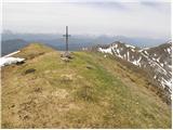
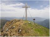
 | Dom Trilobit - Potoški Stol (via Rida)
Potoški Stol is located between Hochstuhl and Weinasch on the border with Austria. Just a few metres below the grassy peak, a cross is erected. T...
4 h |
 | Poljana (Završnica) - Potoški Stol (Žirovniška pot)
Potoški Stol is located between Hochstuhl and Weinasch on the border with Austria. Just a few metres below the grassy peak, a cross is erected. T...
4 h 25 min |
 | Mače - Cjanovca (Mačenska pot and on SE ridge)
Cjanovca is the peak east of Storžič and south of Sredni vrh. It is a peak that can be seen from Kranj and the surrounding area. The southern slo...
3 h 35 min |
| Mače - Cjanovca (over Kozjek and on SE ridge)
Cjanovca is the peak east of Storžič and south of Sredni vrh. It is a peak that can be seen from Kranj and the surrounding area. The southern slo...
3 h 45 min |
| Mače - Cjanovca (Mačenska pot and via Dolga njiva)
Cjanovca is the peak east of Storžič and south of Sredni vrh. It is a peak that can be seen from Kranj and the surrounding area. The southern slo...
3 h 30 min |
 | Ukanc - Vogel (via planina Zadnji Vogel)
When you hear the name Vogel, many people first think of the Vogel ski resort, which is located near the peak of the same name. From the north si...
4 h 30 min |
 | Ukanc - Vogel (via Globoko)
When you hear the name Vogel, many people first think of the Vogel ski resort, which is located near the peak of the same name. From the north si...
4 h 15 min |
 | Tolminske Ravne - Vogel (on mule track and over Globoko)
When you hear the name Vogel, many people first think of the Vogel ski resort, which is located near the peak of the same name. From the north si...
4 h 15 min |
 | Podkraj / Unterort - Petzen (Kordeschkopf) (Peca (Kordeževa glava))
Kordeževa glava, better known as Peca is the highest summit in the mountain chain Peca. It is located on the border with Austria above Mežiška do...
5 h 5 min |
 | Podpeca (Mitnek) - Petzen (Kordeschkopf) (Peca (Kordeževa glava)) (easy path)
Kordeževa glava, better known as Peca is the highest summit in the mountain chain Peca. It is located on the border with Austria above Mežiška do...
4 h 15 min |
 | Koča na Pikovem - Petzen (Kordeschkopf) (Peca (Kordeževa glava)) (via saddle Vrh šteng and on easy path)
Kordeževa glava, better known as Peca is the highest summit in the mountain chain Peca. It is located on the border with Austria above Mežiška do...
4 h 15 min |
| Podpeca (Helenski potok) - Petzen (Kordeschkopf) (Peca (Kordeževa glava)) (via Mirjanca and on easy path)
Kordeževa glava, better known as Peca is the highest summit in the mountain chain Peca. It is located on the border with Austria above Mežiška do...
4 h 40 min |
| Topla (Burjak) - Petzen (Kordeschkopf) (Peca (Kordeževa glava)) (via Mala Peca and on easy path)
Kordeževa glava, better known as Peca is the highest summit in the mountain chain Peca. It is located on the border with Austria above Mežiška do...
4 h |
 | Dom v Lepeni - Velika Baba
Velika Baba is the highest peak of the eastern ridge above the Lepena valley. From the summit, which has a registration box, there is a beautiful...
4 h |
 | Hermsberg - Dobratsch / Dobrač
Dobratsch is a massive mountain range located west of Belgrade. Its highest peak is the 2166m-high Kuhriegel, which has taken the name Dobratsch ...
4 h |
| Bleiberg Kreuth (Wurzach) - Dobratsch / Dobrač
Dobratsch is a massive mountain range located west of Belgrade. Its highest peak is the 2166m-high Kuhriegel, which has taken the name Dobratsch ...
4 h |
 | Weissensee - Latschur (via Almspitz)
At 2236 metres, Latschur is the highest peak in the mountain group of the same name. The summit, on which the cross stands and has a signing box,...
4 h 15 min |
 | Weissensee - Almspitz (via Techendorfer Alm)
Almspitz is a 2,180-metre peak in the Latschur Group. The grassy summit offers a beautiful view of Gailtaler Alps, Carnic Alps, Julian Alps and t...
4 h |
 | Weissensee - Eckwand (via Karalm)
Eckwand is a 2221-metre peak in the Latschur Group. The grassy summit on which the cross stands offers a beautiful view of Gailtaler Alps, Carnic...
5 h |
 | Weissensee - Hochstaff (via Karalm)
Hochstaff is a 2217-metre peak in the Latschur Group. The grassy summit on which the cross stands offers a beautiful view of the nearby ski slope...
5 h |
 | Goldberg - Jaukenstöckl
Jaukenstöckl is a 2209m high peak located on the western side of the Jauken lookout ridge. From the top, where the statue of St. Mary stands, the...
3 h 45 min |
 | Goldberg - Jaukenhöhe
Jaukenhöhe is a little visited peak in the Jauken ridge. It is located to the west of Torkofl, which at 2276m is the highest in the ridge. The gr...
3 h 45 min |
 | Dom v Lepeni - Mali Šmohor
Mali Šmohor is a scenic peak located south-east of Lake Krn. From the summit, which has a registration box, there is a beautiful view of the near...
4 h |
 | Rosenbach - Kleiner Frauenkogel/Koprivnjak
Kleiner Frauenkogel (Little Frauenkogel) is a 1754 m high peak located on the Austrian side of the Karavanke Mountains. From the top, where the c...
3 h 30 min |
 | Podkraj / Unterort - Wackendorfer Spitze
Wackendorfer Spitze is the northernmost two-thousander in the Pec mountain range. From this inconspicuous peak, in fine weather, we can enjoy a m...
5 h |
 | Podkraj / Unterort - Wackendorfer Spitze (on path P7)
Wackendorfer Spitze is the northernmost two-thousander in the Pec mountain range. From this inconspicuous peak, in fine weather, we can enjoy a m...
5 h 5 min |
 | Podkraj / Unterort - Feistritzer Spitze
Feistritzer Spitze is a 2113 m high peak located on the Austrian side of Pec. From the top on which the cross stands, you have a beautiful view o...
4 h 45 min |
 | Podkraj / Unterort - Feistritzer Spitze (on path P7)
Feistritzer Spitze is a 2113 m high peak located on the Austrian side of Pec. From the top on which the cross stands, you have a beautiful view o...
5 h 30 min |
 | Podkraj / Unterort - Končnikov vrh (Peca)
Končnikov vrh is a 2109 m high mountain located in the central part of Pec. The grassy peak offers a beautiful view along the Pec ridge and the m...
4 h 20 min |
 | Rudenska grapa - Gladki vrh (Ratitovec)
Gladki vrh is the most visited peak in the Ratitovec mountain range with an altitude of 1667 m. The uncultivated summit, on which the viewing pla...
4 h |
 | Koča pri Savici - Kser
Kser is a less distinct peak located in the ridge of the Lower Bohinj Mountains, more precisely between Tolminski Kuk and Mahavščko. The summit, ...
4 h 30 min |
 | Susalitch - Zajčnik
Zajčnik (also Blekova) is a 1746 m high peak located northeast of Voška. The partially vegetated peak, which borders between Slovenia and Austria...
3 h 35 min |
| Korpitch - Zajčnik
Zajčnik (also Blekova) is a 1746 m high peak located northeast of Voška. The partially vegetated peak, which borders between Slovenia and Austria...
3 h 35 min |
 | Ukanc - Visoki Orlov rob (via Žagarjev graben)
Visoki Orlov rob is an 1800 m high peak located in the immediate vicinity of the upper station of the single-seater Šija. The summit, located sli...
3 h 45 min |
 | Parking Alpspitzbahn - Osterfelderkopf
Osterfelderkopf is a 2033 metre high peak in the Wetterstein mountain group. The summit is very well visited as it can also be reached by the Alp...
4 h 15 min |
 | Stary Smokovec - Slavkovsky štit
Slavkovsky štit is the fourth highest peak in High Tauern and is 2,452 metres high. It is located south of the Velka Studena Valley, and north-we...
4 h 10 min |
 | Podrožca / Rosenbach - Kamnica (Komnica) / Ferlacher Spitze
Kamnica is a lookout mountain located on the Austrian side of Karawanks, more precisely north of Kepe. From the top, where there is a cross, a re...
3 h 55 min |
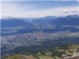 | Hungerberg (parking lot at the station of funicular) - Hafelekarspitze (from Hungerberg on path 216)
Hafelekarspitze is Innsbruck's home mountain and the most popular peak in one of the most admired ridges of the Eastern Alps: the Nordkette, whic...
4 h |
 | Bottom cable car station Patscherkofelbahn - Patscherkofel (path 350 via Lanser Alm and Zirbenweg)
Patscherkofel is a vast and scenic mountain rising above Innsbruck, the capital of the Austrian state of Tyrol. The mountain is one of the most p...
4 h |
 | Losenheim (Parkplatz am Schneeberg) - Klosterwappen (Schneeberg) (via Schauerstein)
Schneeberg is the easternmost and, at the same time, the northernmost of the two-thousand peaks of the Alps, with its Kaiserstein (2061 m) and Kl...
4 h 15 min |
 | Losenheim (Parkplatz am Schneeberg) - Klosterwappen (Schneeberg) (past Witzanikreuz)
Schneeberg is the easternmost and, at the same time, the northernmost of the two-thousand peaks of the Alps, with its Kaiserstein (2061 m) and Kl...
4 h 35 min |
 | Reichenfels (bridge over Labotnica / Lavant) - Peterer Riegel (via Höllgraben)
...
4 h 35 min |
 | Oberort (parking lot Grüner See) - Messnerin (Kamplsteig)
...
3 h 30 min |
 | Seetal - Hochschwab
...
5 h |
| Seetal - Hochschwab (past Schiestelhaus)
...
5 h 5 min |
 | Losenheim (Parkplatz am Schneeberg) - Kaiserstein (Schneeberg) (via Schauerstein)
...
4 h 3 min |
 | Ljubunčić - Velika Golija (Veliki vrh)
...
3 h 30 min |
 | Kapellen - Windberg (northern path)
...
3 h 55 min |
| Kapellen - Windberg (southern path)
...
3 h 55 min |