Bottom cable car station Patscherkofelbahn - Patscherkofel (path 350 via Lanser Alm and Zirbenweg)
Starting point: Bottom cable car station Patscherkofelbahn (904 m)
| Lat/Lon: | 47,22208°N 11,42516°E |
| |
Name of path: path 350 via Lanser Alm and Zirbenweg
Time of walking: 4 h
Difficulty: easy marked way
Altitude difference: 1342 m
Altitude difference po putu: 1342 m
Map: Innsbruck und Umgebung, 31/5 1:50.000
Recommended equipment (summer):
Recommended equipment (winter): ice axe, crampons
Views: 392
 | 1 person likes this post |
Access to the starting point:
From Ljubljana, take the motorway past Salzburg towards Munich. At the Dreieck Inntal multi-level junction, take the A93 towards Innsbruck/Kufstein/Brenner. On returning to Austria, continue to exit 75 in the route Innsbruck-Mitte. At the large roundabout, take the third exit towards Igler Str. Continue along the road, which climbs moderately, past the settlements of Vill and Igls. Following the signs for Patscherkofel Talstation, shortly after Igls, turn left at the crossroads and follow the road to a substantially large parking lot at the bottom of the cable car station, where you park. The parking fee is €6 for the whole day and will be refunded if you buy a lift ticket. Free parking is available a little further down the road.
Alternatively (to avoid buying an Austrian vignette): from central Slovenia, take the A2 motorway to one of the border crossings with Austria and continue to Lienz. Continue on the road 108 past Matreia and Osttirol and take the mountain expressway over the Felbertauern Pass (toll road, in 2020 the price was €11 for cars). In Mittersill, take the B165 and climb the narrower road to the Gerlos Pass (1628 m; fee €10). From there, descend to the point of the same name and continue to the junction with the B169. After about 20 km, join the B171 (direction Schwaz/Jenbach/Wörgl/Strass i. Z. ), which you follow to Hall in Tirol, where you turn left towards Ampassa onto the B171a. After crossing the river Inn, turn right and follow the road past the hamlets of Ampass, Aldrans and Lans to a substantially large parking lot at the bottom of the cable car station, where you park. The parking fee is €6 for the whole day and will be refunded if you buy a lift ticket. There is also a regular J line bus service between the Patscherkofel and Nordkette lift stations and through the centre of Innsbruck.
Path description:
Following the signs for Patscherkofel and Lanser Alm, from the parking lot at the lower cable car station, follow the dirt road along the ski slope up to the junction with the asphalt road, which leads relatively quickly to the Heiligwasser guesthouse. Just below the guesthouse, turn left onto a wide forest road, following the signs for route 350. Along the road you can take a number of unmarked but well-trodden shortcuts through the forest - but don't go too high. After a good hour and a half's walk from the starting point, take a fork on a narrower path which leads over a small bridge over a stream to mountain pasture Lanser, where you can have a snack while enjoying a wonderful view of the Inn valley.
From mountain pasture continue south towards the upper cable car station. The route in this part passes through idyllic woodland, from which you enter the open fields below the summit of Patscherkofl; from there it is only a few minutes' easy walk to the Patscherkofel Schutzhaus hut and the Patscherkofel upper cable car station Patscherkofelbahn.
At the signpost near the hut, rejoin the 350 route; from here to the crossroads just below the summit you will follow the extremely popular, panoramic and relatively gentle Zirbenweg. It traverses the entire northern and eastern slopes of the Patscherkofl in a large arc, all the while offering magnificent views of the hamlets in the Inn valley and the Karwendel mountains above. After a good 30-minute walk, leave the Zirbenweg at the Boschebenhütte hut at an altitude of about 2080 m and follow the well-marked path steeply up to the west-facing summit of the Patscherkofl. Shortly before the summit, we climb a broad lookout ridge and within a few minutes we reach the summit plateau, where a large beacon and a cross await us at a selected point designated for the exposure of the summit of Patscherkofl.
From Patscherkofel Schutzhaus, the summit can be reached much more quickly by more direct official routes or by well-marked unmarked shortcuts.

Pictures:
 1
1 2
2 3
3 4
4 5
5 6
6 7
7 8
8 9
9 10
10 11
11 12
12 13
13 14
14 15
15 16
16 17
17 18
18 19
19 20
20 21
21 22
22 23
23 24
24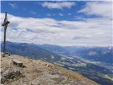 25
25
Discussion about the trail Bottom cable car station Patscherkofelbahn - Patscherkofel (path 350 via Lanser Alm and Zirbenweg)