|
| mojcej'7225. 07. 2009 12:06:07 |
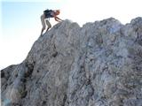
On Thursday, 23.7., I was at Korošica (with the intention also to go to Ojstrica to check the path, as I plan next time to take my 8-year-old daughter), I left from Podveža village past planina Vodole, the whole path was super, sunny and almost no wind ... on the sunny plateau before Kocbek Hut the wind gusts knocked me down on the flat plain, unusually strong .. so preventively no ascent to Ojstrica ... strong wind confirmed by two experienced hikers from Kamniško sedlo-Planjava-Ojstrica ... so when SW wind blows don't go above 2000 m.
|
|
|
|
| bandy25. 07. 2009 12:18:08 |
Wind was blowing hard... wife and I did the same route from Planina Podveža-Korošica-Ojstrica. On the ridge opening view to Logarska dolina the wind gusts were so strong we had to leave backpacks 100m below summit as we'd risk too much with them. Gusts were at times so strong they took your breath and pressed you to rocks. We met hikers who 150m from top decided not to continue the path just because of wind, on top though we met quite a few hikers.
|
|
|
|
| 100jan25. 07. 2009 13:32:12 |
Yes, it was horribly windy. Friend who with backpack weighs 50 kg fluttered in the wind several times on the ridge of Zeleniške špice.
 1 1
|
|
|
|
| frajer29. 07. 2009 12:35:35 |
Yesterday brother and I were on Ojstrica via Kopinškova climbing path and it was excellent (despite mist on top. Returned via Škarje.
Path is well passable, only one snow patch left on western slope...
|
|
|
|
| tplaninsek31. 07. 2009 13:42:21 |
You mention snow patch on western slope. Can I avoid it or do I need ice axe, crampons?
|
|
|
|
| panda31. 07. 2009 16:00:19 |
Snow patch is on north side when crossing west in Kopinšek route. You can avoid the snow patch by bypassing it on the lower side.  Tested a week ago. Tested a week ago.
|
|
|
|
| velkavrh23. 08. 2009 10:40:56 |
When weather improves I plan to go to Ojstrica from Kamniška Bistrica via Šraj pesek. Wondering if anyone went recently on this unmarked path. Grateful for any info. Nice mountaineering greetings!
|
|
|
|
| robin23. 08. 2009 11:26:36 |
In case you're planning to Šraj pesek via Skok I can tell you that a month ago the path from Orglic to Skok was very easy to follow but I didn't notice any cairns. In Skok you have to be careful as it's quite smooth and if damp probably a bit uncomfortable. Well on top of Skok then I didn't immediately find a well trodden path and took my own line. You know you're on right path when after 5-10 min you see on tree and rock dots, arrows and NŠ (guess someone marked on initiative to Najnar štant). From there on easy to follow again. At top of scree in Šraj pesek you gotta go straight in my opinion. I veered a bit left (looked nicer somehow) and had to bushwhack through scrub back to path.
Hope this helps you.
|
|
|
|
| velkavrh23. 08. 2009 11:37:17 |
Robin, thanks! Šraj pesek has really been tempting me for some seasons now, now I've decided to try it. Otherwise I prefer marked paths, even if marked as very difficult with cables, pegs and pitons. Otherwise I have the mountain guide by Andrej Stritar from Sidarta and very accurate special maps. Orientation doesn't cause me problems either.
|
|
|
|
| marko123. 08. 2009 11:43:13 |
The only danger on this path is to climb the twenty-meter jump. The rock is very smooth along the entire length; there are two tiny pitons. And now I don't know if water is currently flowing over the jump. Last time, when I was at the end of June, the stream bed was dry. Otherwise the path is well trodden and visible. Only when you reach Pl. Petkove njive the path to the crater gets lost for a while and you have to continue towards Pl. Korošica off path. You can find some photos in kamniško savinske alpe, third page, article title KAMNIŠKA BISTRICA-KOROŠICA-PLANJAVA-KAMNIŠKO SEDLO. Author Marko1
|
|
|
|
| velkavrh23. 08. 2009 12:00:13 |
Thanks, Marko1, I appreciate and am grateful for every answer and advice! Maybe we meet somewhere else!
|
|
|
|
| velkavrh31. 08. 2009 09:36:22 |
I write this text only to warn about the traps of Šraj pesek, this is a variant of the unmarked path from Kamniška Bistrica to Korošica. I really set off on this path on Friday, 28.08.2009. I prepared well for the path, but I didn't know the path. I already started wrong at the Orglice waterfall. You have to go along the trail that turns left before the stream bed before the waterfall and runs along the left slope by the stream for quite some time and nicely avoids the gorge, then crosses the stream bed and runs along the left bank. Then it should cross the stream bed again, but I missed the path there and didn't find it anymore. As I mentioned, I started at the waterfall on the left slope, where there is a poorly visible path that is almost impassable when wet. Above it got lost, so I continued along the stream bed to the more difficult climbing part, so I continued along the left slope, where I came across the real path and followed it nicely to the crossing over the stream bed. There I apparently missed the direction and from there I went wrong. I continued along the stream bed almost to the top, where it broke for me. I climbed over the first obstacle, the second was too demanding, so I had to decide to turn back. Unfortunately, the first was also too demanding for descent, so I had to jump into the sand. One leg held, the other didn't. Slowly I descended back. This time I followed the path that I had found before and which brings you nicely in front of the waterfall. The waterfall is currently almost without water. This was a lesson for me that at least alone, I won't venture on unmarked paths that I don't know anymore. I have a cast on my leg and so my hiking season is closed for this year. But nevertheless, nice mountaineering greeting!
|
|
|
|
| BT8831. 08. 2009 11:55:03 |
Yes, I went through there a few years ago, my alpinist buddy led the thing and nothing special; really one can get tangled somewhere. Quick recovery I wish you and soon repetition of the path because it's not bad.
|
|
|
|
| velkavrh31. 08. 2009 12:17:18 |
Correction: turns right before the stream bed and runs along the right slope.
|
|
|
|
| velkavrh31. 08. 2009 12:17:24 |
Correction: turns right before the stream bed and runs along the left slope.
|
|
|
|
| gregcs131. 08. 2009 13:10:42 |
On pathless terrain a piece of rope often comes in handy...
|
|
|
|
| geppo31. 08. 2009 14:00:38 |
|
|
|
|
| velkavrh1. 09. 2009 10:43:06 |
Geppo, I read everything that was recorded and it really excites me. Next year I really have to find a guide, I already know who I'll ask and walk this Sraj pesek.
|
|
|
You must log in to post a comment:
If you do not yet have a username, you must first
register.