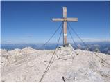
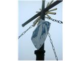
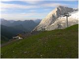
 | Mangartsko sedlo - Mangart (Slovenian way)
Mangart (also Mangrt, both spellings are grammatically correct) is a mountain that receives a very high number of visitors in summer. Access to t...
2 h |
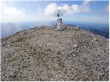
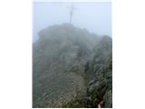
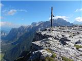
 | D station - Visoki Kanin
Visoki Kanin is the highest peak of the Kanin Mountains. From the summit on which the cross stands, you have a beautiful view of the western Juli...
2 h 30 min |
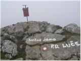
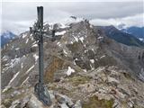
 | D station - Mali Kanin
Mali Kanin is the neighbouring mountain of the better known Visoki Kanin. The summit has a beautiful view of the Kanin mountain range and the pea...
2 h 45 min |
 | Bukovnik - Velika Raduha (climbing way)
At 2062 m, Velika Raduha is the highest peak of Raduha, a mountain range rising steeply to the east of Robanov Kot. From the summit, which has a ...
2 h 25 min |
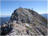
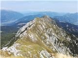
 | Vršič - Mala Mojstrovka (Hanzova pot)
Mala Mojstrovka is one of the most visited peaks in the Julian Alps due to the relatively high altitude of the starting point. From the summit, w...
2 h 15 min |
| Erjavčeva koča na Vršiču - Mala Mojstrovka (Hanzova pot)
Mala Mojstrovka is one of the most visited peaks in the Julian Alps due to the relatively high altitude of the starting point. From the summit, w...
2 h 25 min |
 | Koschutahaus - Koschutnikturm (Košutnikov turn) (ÖTK Steig Neu)
Košutna Turn is the highest peak in Slovenia's longest ridge, the Košuta. From the top, you have a beautiful view of the entire ridge. Austria an...
2 h 45 min |
 | Jakobe - Petzen (Kordeschkopf) (Peca (Kordeževa glava)) (climbing way)
Kordeževa glava, better known as Peca is the highest summit in the mountain chain Peca. It is located on the border with Austria above Mežiška do...
2 h 15 min |
 | Jochalm - Kleiner Reißkofel (path 235)
Kleiner Reißkofel is a 2161 metre high mountain east of Reißkofl. From the summit on which the cross stands, you can enjoy a beautiful view of th...
2 h 25 min |
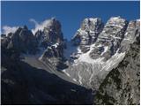
 | Rifugio Auronzo - Monte Paterno (via east ridge)
Monte Paterno is a 2744 metre high lookout. The view from the top is spectacular on all sides, with the Tri Cine/Tre Cime to the west standing ou...
2 h |
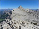
 | Passo di Giau - Averau
Averau is a 2649m high peak located between two Alpine passes, the "Passo di Giau" and the "Passo Falzarego" (south-west of Cortina d'Ampezzo). F...
1 h 55 min |
| Passo Falzarego - Averau
Averau is a 2649m high peak located between two Alpine passes, the "Passo di Giau" and the "Passo Falzarego" (south-west of Cortina d'Ampezzo). F...
2 h 30 min |
| Rifugio Bai de Dones - Averau (via Rifugio Cinque Torri)
Averau is a 2649m high peak located between two Alpine passes, the "Passo di Giau" and the "Passo Falzarego" (south-west of Cortina d'Ampezzo). F...
2 h 45 min |
| Rifugio Bai de Dones - Averau (Trincee)
Averau is a 2649m high peak located between two Alpine passes, the "Passo di Giau" and the "Passo Falzarego" (south-west of Cortina d'Ampezzo). F...
3 h |
 | Jakobe - Končnikov vrh (climbing way)
Končnikov vrh is a 2109 m high mountain located in the central part of Pec. The grassy peak offers a beautiful view along the Pec ridge and the m...
2 h 45 min |
 | Plockenpass - Creta di Collinetta / Cellon (Via ferrata Steinberger Weg)
Creta di Collinetta/Cellon is a 2238 m high mountain located west of the Plockenpass. From the top with a cross, you have a beautiful view of the...
3 h |
 | Koča Porze - Porze / Cima Palombino
Porze is a 2599 m high mountain in the border/main ridge Carnic Alps, above the upper reaches of the Zilja River. The rocky peak structure above ...
2 h 30 min |
 | Koča Porze - Porze / Cima Palombino (via notch Porze (Austrian secured path))
Porze is a 2599 m high mountain in the border/main ridge Carnic Alps, above the upper reaches of the Zilja River. The rocky peak structure above ...
2 h 30 min |
 | Carbonin - Monte Fumo / Rauhkofel (Northern route)
Monte Fumo is a 2114-metre-high mountain in the Cristallo mountain group. The summit, which is located in close proximity to the highest peaks of...
2 h 30 min |
| Carbonin - Monte Fumo / Rauhkofel
Monte Fumo is a 2114-metre-high mountain in the Cristallo mountain group. The summit, which is located in close proximity to the highest peaks of...
2 h 45 min |
 | La Crusc - L'Ciaval / Kreuzkofel
L'Ciaval is a 2,907-metre-high mountain in the Lavarella mountain group. The mountain and the entire ridge in which it is located are recognisabl...
3 h |
 | Passo di Fedaia - Bech da Mesdi (Ferrata delle Trincee)
Bech da Mesdi is a 2727 metre high peak located north of Passo Fedaia. The summit is known mainly for the interesting Ferrata delle Trincee (Trin...
2 h 30 min |
 | Landro - Monte Piano (Via Ferrata Bilgeri)
Monte Piano (Toblacher Kreuz) is a 2305-metre-high mountain located on the north-western edge of the Monte Piana plateau. Near the summit there a...
3 h |
 | Maria Waldrast - Lämpermahdspitze (pot preko severnega grebena)
Lämpermahdspitze is a slightly lesser-known mountain, located to the south of the famous and popular Serles. Despite its lower altitude and lower...
3 h 15 min |