Mangartsko sedlo - Mangart (Slovenian way)
Starting point: Mangartsko sedlo (2055 m)
| Lat/Lon: | 46,4437°N 13,6416°E |
| |
Name of path: Slovenian way
Time of walking: 2 h
Difficulty: very difficult marked way
Ferata: B
Altitude difference: 624 m
Altitude difference po putu: 624 m
Map: Julijske Alpe - zahodni del 1.50.000
Recommended equipment (summer): helmet, self belay set
Recommended equipment (winter): helmet, self belay set, ice axe, crampons
Views: 411.217
 | 15 people like this post |
Access to the starting point:
a) First drive to Kranjska Gora, then continue via Border crossing Rateče to Itali. Drive towards Trbiž / Tarvisio, then turn left at the beginning of the above-mentioned town in the direction of Bovec. Continue along the regional road towards Border crossing Predel, and just after the border crossing (i. e. when we are on the Slovenian side) turn left towards Mangartsko sedlo. We continue along the road, which is narrow and serpentine in places (it also has some tunnels), to Mangartsko sedlo, where we park at a parking lot at 2050 metres above sea level. The road is toll road.
b) We first drive to Bovec and then continue driving to Border crossing Predel. A few 100 m before the border crossing, after the large arch bridge, turn right towards Mangartsko sedlo. The road continues along a narrow and serpentine road (the road also has a few tunnels), and we follow it to Mangartsko sedlo, where we park at a parking lot at 2050 metres above sea level. The road is toll road.
Path description:
From the parking lot, walk first to Mangartsko sedlo, from where you turn right to the east and continue along a grassy ridge. After a few minutes of easy walking, the trail climbs a little more and on the right south side bypasses the nearby Travnik (2200 m). From here on, the trail becomes a little steeper, and after about 30 minutes of walking from the starting point, it leads to a crossroads where the trail splits into two parts; the Italian trail on the left and the Slovenian trail on the right.
Continue on the right Slovenian path, which crosses a nearby scree slope and leads to the start of the climbing part of the route.
Here you should put on a helmet because of the risk of falling rocks.
The path climbs steeply and is aided by rungs and ropes. Higher up, the route transitions to an artificial ledge, after which you cross a gully exposed to falling rocks (this part of the route is well protected). On the other side of the gully, the path continues to climb steeply, and we have to use our hands to help us in the more difficult places. We continue along and along the wide gully straight up, occasionally passing over deep chasms as we climb. Higher up, the path turns slightly to the left and gradually becomes less difficult. When you see the cross in front of you, you are only a few 10 steps of easy walking away from the top.
You can descend by following the slightly easier Italian route.
Mangartsko sedlo - crossroads 30 minutes, crossroads - Mangart 1:30.

Pictures:
 1
1 2
2 3
3 4
4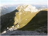 5
5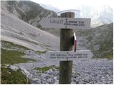 6
6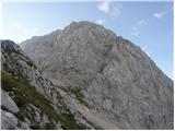 7
7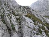 8
8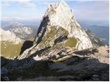 9
9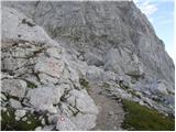 10
10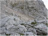 11
11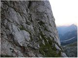 12
12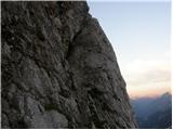 13
13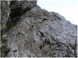 14
14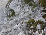 15
15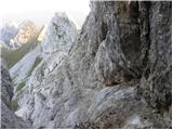 16
16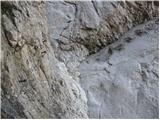 17
17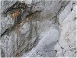 18
18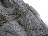 19
19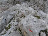 20
20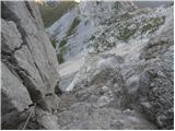 21
21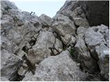 22
22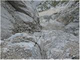 23
23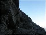 24
24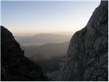 25
25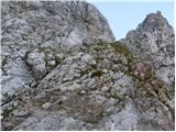 26
26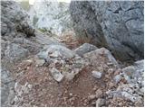 27
27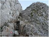 28
28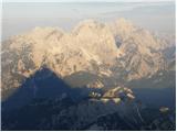 29
29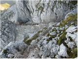 30
30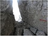 31
31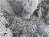 32
32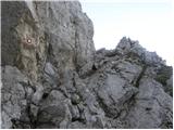 33
33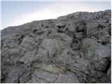 34
34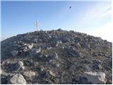 35
35 36
36
Discussion about the trail Mangartsko sedlo - Mangart (Slovenian way)
Show older messages
|
| Guest10. 07. 2006 |
Mangart je tako lepa in mogočna gora,ga vam svetujem turo kar od Belopeških jezer, mimo bivaka na sedlo in od tam na vrh. Tako boste goro doživeli v vsej svoji veličini in lepoti.Lp Vida
|
|
|
|
| Guest4. 10. 2006 |
se ravn ta petek odprvaljam po tej poti gor, pa me zanima ce mi lahko kdo bolj natancno opise pot. lahko tudi na mail ( majaduh@yahoo.com ). ZARES HVALA!!!
|
|
|
|
| Guest4. 10. 2006 |
V petek bo pot na Mangart najverjetneje zasnežena. Za jutri je namreč napovedano sneženje nad 1600m.
|
|
|
|
| Guest4. 10. 2006 |
ojoj, sj res!!!na to pa niti nism pomislila. Jah, bomo vidl kaksne bodo razmere. HVala za opozorilo!!
|
|
|
|
| Guest1. 11. 2006 |
Slovenska smer je zelo lepe in zelo zahtevna,spust samo po italjanski.LP Silvo
|
|
|
|
| majdicst13. 02. 2007 |
Slovenska je super!  Posebej ko te, ko se krčevito oklepaš klina na eni in skale na drugi strani in razmišljaš, kako boš naredil naslednji korak, kot kozorog prehiti Avstrijka srednjih let, ki sploh NE UPORABLJA ROK!!!!!  Šalo na stran.... ni za vrtoglave, je pa resnično čudovit vzpon z izjemnimi razgledi. Kompleta za samovarovanje nisem uporabil (čeprav sem ga tovoril za sabo), čelada je pa obvezna. Definitivno pa odsvetujem spust po tej poti.
|
|
|
|
| Guest21. 03. 2007 |
kera pot je manj zahtevna

|
|
|
|
| Guest21. 03. 2007 |
Se hecaš,POSLUŠAJ MEDIJE IN BOŠ ŠLIŠAL KAJ SE DOGAJA NA MANGARTU!!!!
|
|
|
|
| Guest21. 03. 2007 |
Lažja, a vseeno zahtevna je italijanska. Slovenska pot pa je zelo zahtevna. Pa počakaj na ugodne razmere!
|
|
|
|
| Guest22. 03. 2007 |
Na Mangart sem šel po italjanski gor in dol,pa se mi je pot zdela zahtevna na nekaterih mestih drugače pa nič posebnega.
|
|
|
|
| Guest22. 03. 2007 |
Svetujem po Slovenski gor,po Italijanski dol.Za obe moraš biti dobro pripravljen pas, čelada in počakaj na ugodne razmere .Najugodnejše je poleti,ko lahko turo začneš pri Belopeških jezerih,mimo bivaka Nogara in na sedlo.Veličastna tura,kakor se za veličastno goro kot je Mangart tudi spodobi.
|
|
|
|
| Guest28. 03. 2007 |
Spoštuj vsako goro saj je lahko usoden že en napačen korak... Varuj se, obnašaj se odgovorno do sebe in drugih in gora te bo varovala.
Le tako boš resnično užival in le tako se boš svojega podviga spominjal kot prijetne izkušnje.
Mangrt? Ena najlepših slovenskih gora. Gora, ki ljubi, pa tudi ubija. Zato ni vseeno, kako jo osvajaš!
|
|
|
|
| Guest10. 05. 2007 |
pot in cela gora je zelo super!!!!!!!!!!!!
|
|
|
|
| Guest11. 05. 2007 |
usodna je ta gora !  
|
|
|
|
| fpetel130. 05. 2007 |
Mogoč je pa feratta VIA ITALJANA najlepša pot na Mangart sam ni za vsakega.
|
|
|
|
| Guest30. 05. 2007 |
Lani sem Via Italjano prehodil v ne idealnih razmirah(megla, dež),zato jo v mokrih razmirah odsvetujem,zaradi spoliranih oprimkov od gojzarjev.
|
|
|
|
| Guest31. 05. 2007 |
Mangatr je res prelepa gora. Zato mislim da beseda super zanjo sploh ni primerna.
|
|
|
|
| Guest16. 06. 2007 |
zanima me če je primerno iti na mangart jutri to je 17.6.2007 zaradi neviht zato prosim če mi gdo odgovori glede na vreme?
|
|
|
|
| Guest16. 06. 2007 |
Prebrala sem, da je prišlo do podora na Slovenski smeri, ki je zato zaprta. Pa tudi glede na nevihtno vreme ne bi priporočala...
|
|
|
|
| Guest27. 06. 2007 |
Pot je čudvita,moža postave vljudna in prijazna le nizki oblaki so nam zatirali prelep ragled. Vajo ponovi čim prej JOŽE R.
|
|
|
|
| alojzijus15. 08. 2007 |
14.8. smo šli po Slovenski gor in po Italijanski dol. Start s sedla-zgodaj zjutraj.Slovenska po obnovi lepo varovana, vendar še zmeraj malo krušljiva. Lepo vreme, čudovit razgled. Za manj izkušene varovalni komplet, čeleda obvezna.
|
|
|
|
| Guest15. 08. 2007 |
Škoda da greste vsi z Mangartskega sedla na vrh.Pot z Belopeških jezer je prekrasna,sama gora ,tako mogočna in lepa kot je pa zasluži ,da se za vrh malo bolj pomatramo.Res prelepa tura.
|
|
|
|
| alojzijus16. 08. 2007 |
Se strinjam, samo sem imel s sabo hčerki stari 12 in 16 let, ter sosed sina 1o let. Tako da je bila tura namenjena mlajšim.
|
|
|
|
| Guest16. 08. 2007 |
Ali mi lahko kdo malce razloži pot na Mangart z belopeških jezer? Kje se pusti avto, kaj so glavne postaje na poti... In koliko ur traja vzpon; rad bi bil v enem dnevu gor in dol. Je brez čelade iti gor bolj rizično kot na večini naših markiranih poti? Marko
|
|
|
|
| Guest24. 08. 2007 |
Jutri se odpravljam na Mangart, ali je čelada res nujno potrebna. Sama je namreč nimam...
|
|
|
|
| Guest24. 08. 2007 |
Čelada je potrebna - saj se vendar gre za vašo varnost. Sploh zato, ker gre kar veliko ljudi gor in mimogrede lahko nekdo sproži kamenje. Temu se mogoče lahko izognete, če začnete hoditi zelo zgodaj. Sicer pa je Slovenska pot zelo dobro varovana. Samo po pameti in previdno!
|
|
|
|
| Guest24. 08. 2007 |
Jutri imajo kolesarjenje na Mangart, tako da bo cesta nekaj časa tudi zaprta
|
|
|
|
| Guest24. 08. 2007 |
V hribe se gre peš,ne pa s kolesom.
|
|
|
|
| Guest24. 08. 2007 |
Saj ne grejo na Mangart, verjetno le po cesti do sedla?
|
|
|
|
| Guest26. 08. 2007 |
Pred kratkim smo šli na mangart.Pripeljali smo se do sedla nato šli do bivaka in po ZAHTEVNI poti šli na mangart (potreben je samovarovalni komplet in čelada) Prideš pa tam gor kjer se začne slovenska pot, tako smo še šli na slovensko (Nujna čelada, ker je bilo fejst krušljivo, imeli smo srečo da ni enega zadel velik kamen , ki je šel malo mimo njega)Nato pa po italjanski nazaj dol do sedla!
|
|
|
|
| Guest27. 08. 2007 |
Vjerujem da æete me razumijeti. 25.08. bili na Mangartu. Gore išli Slovenskom poti. Lijepa tura, lijepo ureðena, nije prezahtjevna, nove sajle i novi klinovi na dosta mjesta. Ima ih svugdje gdje je potrebno. Dolje Italijanskom poti do sedla. Za Slovensku pot preporučam komplet za samovarovanje i čelade. Nikad nije na odmet makar æe neki reči da nije potrebno samovarovanje. Mangart predivna gora, svima preporučam.
|
|
|
|
| Guest29. 08. 2007 |
Zelo lepa tura je tudi iz zadnje koritnice, čez mali mangrt in hudo škirbino na vrh.
|
|
|
|
| Guest17. 09. 2007 |
Pozor. VIA ITALIANA - ferata je ZAPRTA. Zelo majhna oznaka, da je ferata zaprta je na poti na Mangart, tako, da se jo zlahka spregleda. V ferati je nekaj izruvanih klinov in pretrgana jeklenica in tako ni možno samovarovanje.
|
|
|
|
| Guest3. 10. 2007 |
v ferati manjka samo en klin.ni problema z samovarovalnim kompletom
|
|
|
|
| planinec8213. 10. 2007 |
Živjo. Zanima me če je bil kdo v zadnjih dneh na Mangartu? V kakšnem stanju je Slovenska pot in ali je kaj snega?
|
|
|
|
| Guest25. 10. 2007 |
la via slovena non è poi così difficile...
|
|
|
|
| klukc291. 07. 2008 |
jst bi rt vprašu če je to dost zahtevna pot
|
|
|
|
| John1. 07. 2008 |
Nisem se prehodil (preplezal) te poti amapk po pripovedovanju in zbranih informacijah je to ena zahtevnejših poti. Tko da preden se povzpneš na Mangart raje opravi manj zahtevne ture, da pridobiš kilometrino in izkušnje.
|
|
|
|
| trinity1. 07. 2008 |
Pot je kar zahtevna, če imaš vrtoglavico ti je ne priporočam Je pa super varovana! Čelada obvezna, samovarovalni komplet pa zelo priporočljiv. Sestop pa seveda po Italijanski strani.
|
|
|
|
| soniq2. 07. 2008 |
Planinski pozdrav vsem skupaj!!! Danes sem prehodil Slovensko smer!! Je prava adrenalinska še posebej zato, ker je bil na izpostavljenih delih sneg! Moti me pa to , da se na to prečudovito goro odpravljajo ljudje brez izkušenj!!!
|
|
|
|
| tanita9. 07. 2008 |
pozdrav, mene pa zanima, če je bil kdo te dni na Mangartu po slovenski in če je še kaj snega. hvala
|
|
|
|
| triglavski9. 07. 2008 |
Bil danes gor. V Slovenski nič snega, varovala brezhibna, čelada obvezna, samovarovalni komplet priporočljiv. Sestopil po Italijanski, kjer že takoj pod vrhom prečimo manjše snežišče, ni nevarno, nekoliko večje nas preseneti na križišču za mang. sedlo - Huda škrbina (smerna tabla), tam sem uredil sestop, ker so se nekateri nevarno dričali kar po zadnji plati, sledi še nekaj manjših snežišč, ki pa niso izpostavljena. Zanimivo, da sem pri vzponu naletel na skupino kakih 25 mladih Čehov, vsi brezhibno opremljeni s čeladami in kompleti, le nekaj jih je bilo vmes v športnih copatih. Sicer nihče ni imel cepina, ki je za ta čas še obvezen del opreme za visokogorje.
|
|
|
|
| tanita12. 07. 2008 |
bila danes na Mangartu, vetrovno in megleno, vseeno lepo. cepin niti ni potreben, v bistvu sem bila edina z njim.. 
|
|
|
|
| triglavski12. 07. 2008 |
Sva že dva. Pa nič hudega, tudi njemu je všeč, če ga kdaj vzameš zraven. Tudi jaz sem ga danes zastonj nosil gor pod Hochalmspitze, pa ga nisem potreboval, ker smo se zaradi slabega vremena že pod ledenikom obrnili. Kolikor mi je znano sta bila danes na Mangartu tudi dva, ki bi ga pa morala imeti, no mogoče sta ga imela skritega v nahrbtniku.
|
|
|
|
| jprim12. 07. 2008 |
Prosim za nasvet, in sicer me zanima kakšna je razlika težavnosti Slovenske in Italijanske poti. V vodniku 50 zavarovanih plezalnih poti piše, da je Slovenska zmerno zahtevna, Italijanska pa izjemno zahtevna pot, ker se držim pravila po težji poti navzgor in lažji navzdol, mi sedaj ni jasno, kako to da se Italijanska pot priporoča za sestop.
LP in hvala za odgovor.
|
|
|
|
| fajti112. 07. 2008 |
Če se prav spomnem, je v vodniku 50 plezalnih poti govora o Ferreti Italiani, ki pripelje z belopeške strani od bivaka Nogara (iz Italije)čez steno na mesto, kjer se razcepite Slovenska in Italijanska smer proti Mangartu. Ferrata Italiana velja za eno težjih ferrat v Julijcih.
Lep planinski pozdrav
|
|
|
|
| Simon2713. 07. 2008 |
Tudi jaz bil včeraj med prvimi gor...megleno in zeloo vetrovno pa vseno zelo lepo. Šli po Italijanski gor po Slovenski pa dol.Vse ok.
|
|
|
|
| triglavski13. 07. 2008 |
Fajti1 ima prav. Tudi vodnike je treba znati brati. Najprej je opisano izhodišče, potem dostop, opis in sestop, na koncu tudi težavnosti. Torej, če bi prebrala celoten opis v vodniku, bi pri sestopu videla, da piše, da sestopimo po poti, ki po italijanskem ozemlju takorekoč obkroži celotno vršno kupolo Mangarta. Via Italiana je seveda popolnoma druga pot, trenutno zaprta, ima drugo izhodišče, priporočen je drug sestop. Je pa tako da skoraj vsi vedo kje se z vrha Mangrta sestopa, razen kakšnega alpinista, ki potem ostane gor.
|
|
|
|
| andrej76713. 07. 2008 |
"Je pa tako da skoraj vsi vedo kje se z vrha Mangrta sestopa, razen kakšnega alpinista, ki potem ostane gor." Ta je pa res dobra
|
|
|
|
| viharnik13. 07. 2008 |
To se je na žalost res zgodilo ne dolgo nazaj,ko so po uspešni preplezani smeri od Loške Koritnice,trije alpinisti v hudem metežu ,nepripravljeni na še vedno zimske razmere,ostali na vrhu.Tretjega so našli na vstopu v smer.Vedno hodite po gorah z budnimi čutili kakor živali,ko jih srečate na poti.Sam tudi poleti nosim s sabo lahko kapo in rokavice,če se odpravim nad 2000m visoko!Srečno-Rok.
|
|
|
|
| jprim13. 07. 2008 |
V gore se odpravim vedno s primernimi podatki in ker v prihodnje mislim na Mangart, že iščem primerne poti. Res je da še nimam zemljevida, prelistala pa sem vodnik, morda res kaj spregledala ... še vedno mi pa ni jasno nekaj, potem takem sta dve Italijanski poti - Via Italiana in še ena ? ... manj zahtevna. Je pa že res, če še nisi bil na Mangartu, potem tudi ne moreš govoriti o tem in tudi ne svetovati, kje se sestopi.
Pa še lep dan, čeprav se pripravlja nevihta. LP!
|
|
|
|
| Rok13. 07. 2008 |
Z Mangartskega sedla vodita na vrh Slovenska in Italijanska pot.
Via Italiana (izjemno zahtevna) pa gre iz doline do Mangartskega sedla (malo nad sedlom se priključi poti od sedla).
|
|
|
|
| triglavski13. 07. 2008 |
Sicer pa vzpon z mangartskega sedla sploh ni neki vzpon v pravem pomenu besede. Vzpon na Mangart se opravi iz Loške Koritnice - v Koncu, Rob nad Zagačami - (vmes skočiši še na Vevnico) Mali Koriniški Mangrt - Huda Škrbina - Mangrt, sestop po slovenski na sedlo in čez Jačke nazaj v Loško Koritnico. To naredite, potem pa kaj napišite, seveda vse v enem dnevu, jaz sem to že večkrat, to je prava tura, vse ostalo so le kratki visokogorski sprehodi.Ali še bolje od Belopeških jezer po Via della Vitta na Vevnico - Rob nad Zagačami in po prej opisani na vrh, varianta je tudi iz Tamarja - Kotovo sedlo - V Koncu in preko Hude škrbine na vrh. Še lepša pa je iz Remšendola preko sedla Stožje na mangartsko planino in potem na sedlo in na vrh. To so poti na Mangrt, ne pa tisti dva kratki s sedla, ki sta v bistvu le zaključek prej omenjenih. Pa to naredite vsaj 50 krat, potem pa kaj napišite.
|
|
|
|
| triglavski13. 07. 2008 |
In še nekaj zgodovine. V bistvu je bila najprej samo ena in to italijanska pot, ki je vodila iz doline še prej preden je bila v 30. letih prejšnjega stoletja s strani Italijanov narejena cesta na sedlo. Po drugi vojni so mangartsko sedlo zasedli jugoslavanski graničarji in Italijani takorekoč niso imeli dostopa na vrh, zato so od bivaka Nogara potegnili še znamenito Via Italino, ker pa je bila bojazen, da potem tudi naši ne bi mogli na vrh so leta 1953 nadelali še slovensko smer. Tako imamo zaradi narodnostnih delitev sedaj dve poti s sedla in eno z vzhoda, ki prihaja iz smeri Loške Koritnice in se združi z ostalimi na Robu nad Zagačami in ena pod njim.
|
|
|
|
| kindir14. 07. 2008 |
Pozdrav,
imam pitanje u vezi Ferrate na sedlo. Namjeravam otici tamo ovog ljeta, ako bude odprta, i zanima me vase misljenje koliko je zahtevna u odnosu na npr. Kopinskovu pot na Ojstricu, zavarovanu na Korosku Rinku, zavarovanu na Rjavinu, Slovensku na Mangrt, Turski zleb, Hanzovu na Malu Mojstrovku i slicne koje sam prosao, uz samovarovanje naravno.
Hvala!
kindir
Lp
|
|
|
|
| Klin14. 07. 2008 |
Kindir, via Italiana je težja od naštetih poti in plezalni del je daljši od zgoraj naštetih. Toda, če se ture lotiš psihično in fizično dobro pripravljen z vso opremo opremo čelada, komplet itd. jo boš uspešno prehodil in ti bo ostala v lepem spominu. Vsekakor pa počakaj na odprtje poti.
|
|
|
|
| panda15. 07. 2008 |
Triglavski: Zakaj si tako "zajedljiv"?! Nismo vsi tako "hitri" kot ti, ki opraviš s takimi turami kot za šalo. Tudi tvoji časi prehojenih poti se z "našimi" ne morejo meriti. Ko primerjam svoj porabljen čas s časom v vodniku (opis določene poti), sem kar v okviru opisanega (mogoče imam cca deset ali petnajst minut fora). In vem, da se s teboj ne morem "meriti", se tudi nočem. Ampak, če nekdo opravi visokogorski izlet iz sedla na Mangrt po Italijanski poti, je to vsekakor priznanje za vsakogar. Če gre po Slovenski, pa kapo dol. Jaz sem npr. bil na Mangrtu po ferrati via Italiana, po po Slovenski in Italijanski, pa se ne hvalim.
|
|
|
|
| triglavski15. 07. 2008 |
Ne gre za "zajedljivost" ampak delati iz dveh poti, ki komaj dosežeta 600 višinskih metrov skoraj doktorat pa res ne gre. Cenim tiste, ki se na sedlo pripeljejo s kolesi in se potem še povzpnejo na vrh. Vse ostale poti pa sem opisal zato, ker so sicer zelo dolge, a tudi zelo lepe. S sedla se pač vsaka mamca sprehodi na vrh, žal. Glede tistih "dveh" tudi žal, sem bil zraven,ko smo gazili meter novega snega v snežnem viharju in potem, ko smo ju pobirali. Kot tudi na žalost je življenje postalo ena sama dirka in pač ni več časa po cel dan capljati po gorah in je kakšno turo treba narediti tudi bolj na hitro. Se gre pa večkrat in več vidi in doživi.Upam, da je panda zadovoljen. Škoda, ker ga ni bilo lani zraven, ko smo 4 dni nosili železje v Slovensko, da smo jo zrihtali tako, kot je, bi tudi jaz njemu dal kapo dol, če bi gor prinesel 25 kg agregat, vmes bi mu pa še bencin po riti kapljal.
|
|
|
|
| Fazo15. 07. 2008 |
@Triglavski: samo zanima me, če si v markacijskem odseku, ker letos sem zaprosil, če bi me lahko kdo obvestil o tem kdaj in kje so priprave pa ni bilo nobenega odgovora, tako da zdaj iščem neko povezavo do tja. V kolikor si, me prosim kontakiraj na e-mail: matevz.fazarinc@guest.arnes.si Lp, Matevž
|
|
|
|
| jprim15. 07. 2008 |
Ni moja praksa, da bi pogosto komentirala s kom, pač povprašam za mnenje drugih, ki so bolj izkušeni in se spoznajo na situacijo, ampak vseeno, gore so od vseh Slovencev, počasnih in hitrih, od tistih, ki znajo uživati v miru in tišini, poduhati to rožico in poslikati to zanimivost, pobrskati po vodnikih in priročnikih o gorskem cvetju, se naučiti nekaj novega o gorah ... in upati na srečno vrnitev iz gore. Prav pošteno pa mi gre na živce sopihanje za mojim hrbtom in nestrpnost do tistih, ki smo malo počasnejši kot dirkači po gorah in tako je to soboto skoraj zdrčal v dolinco nek mlajši gospodič, ker se mu je tako zelo mudilo in niti ni imel toliko časa, da bi se mu lahko vredu umaknila. Gospod "triglavski" spoštujem starejše, izkušenejše planince, ampak v vaših odgovorih je včasih zaslediti kar malo sarkazma, pa ne vem zakaj ... (če bisi prav prebrala vodnik, pa pojdi 50 krat na vrh in potem kaj napiši) pa Slovenija je malo večja kot samo Julijci, in nekateri nimamo možnosti, da bi bili 3 krat na teden v planinah, saj je to precej povezano s stroški, poskušam biti vsaj vsak vikend, če je le mogoče in si takrat napolniti baterije. Pogosto se na kakšno goro ali planinsko pot vračam še naslednji vikend, če mi gora ni prav sedla v mojo dušo in srce. To je moje mnjenje, pa brez slabe volje in lep pozdrav.
Jelči!
|
|
|
|
| viharnik15. 07. 2008 |
Mislim,da imate vsi vsak svoj prav.Po mojih izkušnjah,pri človeku obstaja neki prag kondicije,katerega si ustvariš z ne pretiravanjem,temveč z vztrajnim in rednim treningom.Ključ v nad moči pa biva v umirjenosti duha(stanju brez misli)ter nedolžnosti,kot otrok-v vseh pogledih.Nek mojster tai-chi je rekel,da dolgovečnost,ni plod treninga pač pa posledično od ohranjanja umirjenosti duha!Tudi mi smo pri treningu karateja strmeli v prazno steno,da bo si umirili duha in uravnali energijo.Vsi mi smo otroci enega boga.Duh v nas pa je nesmrten.Nič ga ne more uničiti.Mi le duhovno rastemo v NJEGA ,iz enega življenja v drugega. Ranljiva je le "naša" slabost v nas samih,ki pa ni del nas!Odprimo se zakladom gora in najdimo tisto prvobitnost iz katere smo nekoč vsi prišli.
|
|
|
|
| panda16. 07. 2008 |
Triglavski: Kapo dol pred "tvojimi" dosežki, to je razbrati iz moje "pisarije" zgoraj. Enako pri sodelovanju z markacisti. Če te ne bi to delo veselilo, ga verjetno ne bi počel. Tudi sam precej krat nosim nahrbtnik na ramenih, ki je težak cca 18-20 kg, pa ne jamram (dvo ali tridnevne ture). Saj gre za potešitev mojih duševnih potreb in želja. Tako kot pri tebi!! Bi pa bilo zanimivo objaviti oglas, ko markacisti popravljate katero izmed smeri, koliko prostovoljcev bi se prijavilo za pomoč pri delu (nošenje stvari, pomoč pri popravilih - seveda da pomagajo tisti, ki imajo kar nekaj izkušenj v visokogorstvu in jih ni strah višine....verjetno bi vam bilo v pomoč - zgolj za razmišljanje). Poanta, ki smo/sem jo želel/i napisati je v tem, da gore doživljamo različno. Eni hodimo hitreje, eni počasneje, eni previdno, drugi neodgovorno (zato jih pa moraš žal tudi ti reševati zaradi njihove nepremišljenosti ali neodgovornosti). Če nekdo napiše, da je "osvojil" goro (pa vseeno iz katerekoli smeri), je verjetno zanj dosežek, če ne ga ne bi delil z nami na spletu. Verjetno se ne bo nekdo hvalil, da je v nedeljo zjutraj vstal in odšel peš na Donačko goro in se do kosila vrnil domov. In če to napiše vsako nedeljo, se bom vprašal: Ali se hvali ali pa je nor? Ne, to je njegovo zadovoljstvo, ampak tega ni potrebno izpostavljati vedno znova!! To je zgolj moje mnenje in nisem imel namena nikogar užaliti. Pa veselo planinarite še naprej in pazite nase. Srečno.
|
|
|
|
| viharnik16. 07. 2008 |
Ob časovni stiski za osvajanje vrhov, se da tudi z mountain-bike uživati in doživeti čar gorske narave,pa še za sklepe je manj naporno.Sam sem danes s Šentvida krenil do Sore-Studenčece-vrh Jakoba806m -Katarina-Toško Čelo in pri30km v klance porabil samo 1,30h.Enkratno in zelo prijetno.Lahko kombiniramo tudi z hojo na bližnji vrh!Srečno-Rok.
|
|
|
|
| Nickster24. 07. 2008 |
Na jetra mi grejo dolgi komentarji
|
|
|
|
| jprim24. 07. 2008 |
Pozdravljen Nikster. Kdo te pa sili, da sploh bereš dolge komentarje. Enostavno preskoči jih, nekateri pa si vzamemo toliko časa, da preberemo zapisano, kar je napisal določen avtor in s tem hkrati izkažemo spoštovanje do avtorja. Toliko o tem, pa ne slabe volje, ta med planinci sploh ni, a veš kaj poje Kekec? LP! Jelči
|
|
|
|
| Nickster25. 07. 2008 |
lp Jelči. Ne mslit, da vas ne spoštujem. Prav vsakega iz tega foruma zelo spoštujem. Tudi vaš komentar (čeprav je dolg) se mi zdi vredu in se po pravici povedano strinjam z vami. Vendar pa mislim, da forum ni namenjen dolgim zgodbicam, temveč kratkim in jedrnatim kometarjem. Al pa se motm  Pa lep pozdrav vsem skupaj!
|
|
|
|
| markoskoda9@gmail.com30. 07. 2008 |
Vzpon na Mangart je zelo lepa tura,ker pa sem se je lotil prav od spodaj(čez plaz)je tako bolj popolna,ok.4 ure 45 min.zmerne hoje.Pričeti pa je treba v zelo zgodnjem jutru,če hočeš imeti zgoraj kaj od razgleda,ker pozno dopoldne rad dobi megleno kapo.Škoda,da je za sestop zaprta Feraata Italiana.
|
|
|
|
| amadejx1. 08. 2008 |
Na mangrtu je zelo lepo. 
|
|
|
|
| daša4. 08. 2008 |
Včeraj sva želeli s kolegico iz Belopeških jezer preko koče Zacchi na Visoko Ponco. Ker je pri tabli za Visoko in Srednjo Ponco tabla, da je pot zaprta, sva se dolgih nosov obrnili navzdol in se odpravili preko bivaka Nogara po Via Italiana do Mangartskega sedla. Sicer je tudi na vstopu za Via Italiana tabla, da je pot zaprta, vendar sta na ferati izpuljena le dva klina, drugače je OK. Iz sedla sva šli nato po Slovenski poti na vrh Mangarta, kjer pa je kar mrgolelo ljudi. Nazaj sva šli po Slovenski, od sedla pa po normalki do bivaka Nogaro in do Belopeških jezer. Za celo krožno pot porabili 9 ur,in na koncu so kolena kar rekla hvala, ko sva se vsedli v avto. Cela tura je čudovita, z prekrasnimi razgledi.
|
|
|
|
| triglavski4. 08. 2008 |
To je pa kar lep podvig, lepo.
|
|
|
|
| jersy29. 08. 2008 |
ta pot je podobna kot hanzova na mojstrovko
|
|
|
|
| IvoŠ30. 08. 2008 |
Na Mangart in Slovensko smer imam lepe spomine. Bila je to moja prva plezalna izkušnja iz davnega leta 96. Ena izmed mojih,po spominu ,najlepših,zraven Storžiča,Mojstrovke in letošnjega Turskega žleba in Kotličev  Pa sem v teh letih prehodil oz.splezal marsikatero..hehe
|
|
|
|
| Marco-Slo15. 09. 2008 |
14.9. sem se prvič odpravil na Mangart. Kot sem prebiral v opisih sem se založil z vso potrebno opremo. A kot sem ugotovil, brez potrebe. To je, če si blizu, bol tura za po kosilu. Zame ni bilo nič zahtevnega. Po Slo gor 1.30h z narejenimi saj 50 slikami. Po Italijanski dol v 50 minutah. Oboje iz Mangartskega sedla. Je pa Italijanska res veliko lažja. Bom poizkusil spravit tu gori kako sliko.
Lep pozdrav.
|
|
|
|
| Planjava15. 09. 2008 |
a ni bila pot nič mokra, spolzka in nevarna za zdrs?
O, tu je pa res dvoje dopisovalcev:
eni podirate rekorde, drugi uživamo v lepotah gora....
tudi prav.
Veš, Mangrt je ena mojih naj naj...
lp
|
|
|
|
| Kriška15. 09. 2008 |
Strinjam se s teboj Planjava, dodala bi pa še to, da je žal tule tudi nekaj dopisovalcev, ki omalovažujejo določene poti (dostope) - bodisi, da so "ničvredni" če se do izhodišča lahko dokaj visoko pripelješ (idealno za tiste, ki ne zmorejo več dolgih tur), bodisi da je oznaka "zahtevno" ali "zelo zahtevno" larifari, saj gre tako rekoč za "sprehajalne steze", kamor prileze "vsaka stara mama", ali pa nekakšne lahke tekaške proge ...
Neizurjenim, začetnikom, ljudem s težavami z ravnotežjem pri "globokih pogledih" je to lahko prava past, če ne pogledajo še drugih bolj verodostojnih virov (vodniki).
Za moje pojme nobena od poti na Mangart ni nezahtevna in bi turo odsvetovala začetnikom hoje po gorah.
|
|
|
|
| Marco-Slo15. 09. 2008 |
Pot je bila malce spolzka samo bolj v spodnjem delu, do razcepa slo ali italijanska smer. Ko pa sem prišel na vrh pa sem bil nagrajen z veliko mero sonca. Sem bil na vrhu 2,30h, tako da se mi je na obrazu kar malo poznalo od sonca. Tako da znam jaz hitro skočim na vrh in potem tudi ob lepem vremenu znam gor tudi uživati.
Drugače pa sem kar v pravih letih in z kar nekaj kondicije. Imam pa željo v bližnjih letih tudi malo skočiti na Himalajo, da se prepričam, če so tam res lepše gore (ker jih naši alpinisti tako pogosto obiskujejo), kot so pri nas.
Drugače pa recimo italijanska smer res ni nič kaj zahtevna. Pa ponavadi jih večina ne gre samih kar takoj na tako turo, razen če niso taki ekstremisti kot smo nekateri.
Prosil bi če mi zna kdo pomagati, če se sploh da, da bi tu dodal kako sliko.
Lep pozdrav.
|
|
|
|
| geppo16. 09. 2008 |
Če komentiraš- NE!
Pojdi pod / Trenutne razmere/Mangart/opiši in naloži slike!
Lp
|
|
|
|
| Tadej16. 09. 2008 |
Kot je že Geppo povedal lahko slike naložiš tukaj
|
|
|
|
| Bizy16. 09. 2008 |
Marco-SLo tale tvoja zadnja dva komentarja sta kar neki sumljiva, mislim čudno napisano vse skup. Kar neko podcenjevanje, v drugem koraku neko hvalisanje ne vem, ne vem, meni čudno berljivo... Pa brez zamere!
|
|
|
|
| katy6. 07. 2009 |
Ali je kdo v zadnjem času šel na Mangart iz mangartskega sedla. Po slovenski ali italjanski. Zanima me ali je pot kopna.
Hvala in lp
|
|
|
|
| GITA23. 09. 2009 |
Zadnjič sem bila na Mangartu 22 let nazaj  , takrat še ne polnoletna sem šla s PD. Niti ne vem, po kateri poti smo se povzpeli na sam vrh ampak nisem imela v spominu nobenih težav. Danes sva se odpravila z možem in zgornji komentarji so mi malo kratili spanec in malo me je "stiskalo" od treme zaradi bojda velike zahtevnosti slovenske poti. Naj sem se še tako trudila, na celi poti nisem našla mesta, ki bi mi vsaj malo dvignil adrenalin . Pot je odlično zavarovana, veseli me, da kljub precejšnji "metraži" jeklenic vendarle ni prav vse v železju in je treba prijeti tudi za kakšno skalo. Pravzaprav mi je bila bolj "neugodna" italijanska smer ob sestopu zaradi grušča, ki terja kar nekaj previdnosti.
|
|
|
|
| vidleo129. 09. 2009 |
Trenutno je "slovenska" zaprta zaradi novega podora na cca. polovici poti.
|
|
|
|
| Natassa30. 09. 2009 |
Jaz sem bila na Mangrtu v nedeljo: na odcepu za slovensko pot je tabla "zaprto" -seveda to večine ne odvrne, da se ne bi vzpenjalo po tej poti
|
|
|
|
| triglavski30. 09. 2009 |
Ja očitno ena smrtna žrtev pred dvemi leti ni bila dovolj. Vedeti pa je treba tudi to, da če se nekomu zgodi na zaprti poti nesreča ali sam ne bo mogel sestopiti, bo sam nosil stroške reševanja.
|
|
|
|
| Gorazd G30. 09. 2009 |
Samo eno dobronamerno sporočilo tistim, ki skrbijo za opozorila o zaprti slovenske poti na Mangrt. Dobro bi bilo, če bi to obvestilo bilo tudi na vrhu, saj se vsi ne povzpnejo na vrh z Mangrtskega sedla in potem brez potrebe rinejo v težave, namesto da bi sestopili po italijanski poti. Vsi žal ne berejo obvestil o zaprtosti planinskih poti.
|
|
|
|
| Gorazd G2. 10. 2009 |
Triglavski, malo sem prebral zgornje komentarje in našel tvoje zelo zanimivo razmišljanje, da vzpon z Mangrtskega sedla na vrh sploh ni pravi vzpon. Kako so na tvojo aroganco, zajedljivost in obnašanje do manj sposobnih od tebe reagirali drugi si lahko prebral. O tem ne bom sodil. Toda ... Če je ravno vzpon iz Koritnice, skok na Vevnico, prečenje čez KMM, sestop po slovenski poti in čez Jačke nazaj v dolino (in to v enem dnevu, uau, to pa je nekaj - ti povem, da se da (preverjeno) brez problemov dodati še Kotovo špico in V koncu špico) "prava" tura na Mangrt, potem bi res tabla o zaprtosti poti sodila tudi na vrh. Če se s tem ne strinjaš, je to tvoj problem. In če se s tem ne strinjaš samo zato, ker je to napisal Gorazd, tudi. Želim ti, da še naprej uživaš v tem, da se na hribi.net obnašaš kot mali (če ne že kar veliki) Bog, ostali smo pa ene ovčke, ki vdano capljamo za tabo.
In še nekaj. Slovenščina ima dvojino torej se napiše: "Ja očitno ena smrtna žrtev pred dvemi leti ni bila dovolj", temveč "... pred dvema letoma ..."
Ja, očitno res ni bila dovolj ... Torej še enkrat: Tabla o zaprtosti poti sodi tudi na vrh.
|
|
|
|
| triglavski2. 10. 2009 |
Gorazd očitno se ti pozna, da ti prekleto manjkajo gore. Sicer pa imamo naročene tri table, eno za mang. sedlo, eno za vstop v slovensko in eno za na vrh. Upam, da si potolažen. In ne bodi užaljen kot mali otroček, če ti na tvoj meil ne odpišem takoj.
|
|
|
|
| Gorazd G2. 10. 2009 |
"Imamo naročene tri table, eno za mang. sedlo, eno za vstop v slovensko in eno za na vrh."
To bi lahko napisal (namesto arogantnega odziva) že takoj in dodatne besede sploh ne bi bile potrebne. Hvaležen sem ti, da boste table namestili.
Gore ... Danes je res bolj turobno zunaj, sicer pa smo v gorah več kot kadarkoli prej, zato ne ciljaš v pravo tarčo. Gre samo za tvojo neverjetno ošabnost s katero odgovarjaš vsem, ki vedno in povsod ne trobijo s tabo v isti rog.
Srečno!
|
|
|
|
| šodrovec2. 10. 2009 |
Ojej, duš, še niti dobro prijavil se nisem na ta forum, pa že spremljam "špetir" ...
Prepričan sem sicer, da se točno ve (je predpisano), kako postopati ob zapiranju planinskih poti, menim pa tudi, da kakšno dobronamerno dodatno forumsko opozorilo prav nikjer in nikomur ne more škoditi.
Me pa vseeno zanima, ko se ravno piše o nesreči pred dvema letoma, ali je bila takrat opozorilna tabla o zaprtosti poti postavljena tudi na vrhu Mangarta oz. na zgornji strani podora? Saj res, kakšno je pa stanje na terenu dokler naročenih tabel še ni?
Pa brez zamere in (zle) namere, firbec pač.
|
|
|
|
| Gorazd G2. 10. 2009 |
Pred dvema letoma table na vrhu ni bilo (vsaj jaz je nisem opazil), zato sem tudi napisal prvo dobronamerno sporočilo - da bi se letos neslo tablo tudi na vrh. Nič drugega. Šodrovec ne sekiraj se, hribovci smo večinoma čisto miroljubni ljudje, sem in tja pa rečemo tudi kakšno bolj na trdo.
|
|
|
|
| IgorZlodej14. 06. 2010 |
Slovenska na Mangrt je zaenkrat še zaprta zaradi lanskega podora, sicer pa, ko bo skopnel sneg se bo prčelo popravilo. Ko bo odprta boste obveščeni.
|
|
|
|
| matejd14. 06. 2010 |
Igor, hvala za vaš odgovor! lpm
|
|
|
|
| stankoju17. 07. 2010 |
Igor a je že kaj novega glede Slovenske poti, so se že izvajala kakšna dela na popravilu poti.Naslednji viken imamo v planu gor pa nas zanima.
Lp Stanko
|
|
|
|
| skalar503. 08. 2010 |
včeraj, 2. avgusta je na vrh ( sam sem šel levo po italijanski, bp) prišla četverica in povedala, da so slovensko (popravljeno) ravno ponovno odprli... Sicer krasen razgledni dan, vrhnji križ v podnožju obkrožen s snegom.
|
|
|
|
| ladko6. 08. 2010 |
Zanima me če je še kje sneg na Slovenski poti?
|
|
|
|
| simonavolf8. 08. 2010 |
na Slovenski poti ni več snega, včeraj 7.8. smo se sprehodili po tej poti, je lepo varovana na odseku kjer so bila popravila. predlagam da kdor bi se rad sprehodil po Slovenski poti naj se vzpenja po njej in spušča po Italijanski.
|
|
|
|
| speedy_barb30. 08. 2010 |
včeraj (29.8.) smo šli s kolegi po Slovenski gor, pa po italijanski dol. suprca. enkratni razgledi, lepo urejena pot, jeklenice fajn pričvrščene. moram rečt, da smo ful uživali.
me je pa nekaj močno, močno zmotilo.
folk, ki je prihajal za nami na Mangart. sm se kar za glavo prijela. da ti gre gor v zlizanih Puma supergah, pa frotirasti trenirki, drugi v kavbojkah in supergah, tretji v dizajnarskih oblačilih itd. itd. -vsi BREZ čelade.... pa sej se vprašaš - a jim res ni nič mar za varnost? samo en zdrs je potreben, ali pa en kamen, ki se sproži, pa je tu lahko katastrofa.
dajte no, ljudje božji - pomislite malo, preden se podate v konkretnejše hribe / gore. saj se gre v končni fazi za vaša in naša življenja.
|
|
|
|
| irena2504. 09. 2010 |
Zanima me, kakšne so razmere na Mangartu ta vikend. Hvala.
|
|
|
|
| turbo4. 09. 2010 |
Vremenu primerne. Nekaj snega, požled, megla, dež/sneg, v nedeljo morda nekaj malega sonca.
|
|
|
|
| vik4. 09. 2010 |
Uživanje, ampak zgodaj. Čeprav imela kar preko 2 uri jutranje vožnje, bila gor že zelo zgodaj. Sonce, modro nebo, nekaj vetra ki sprašuje, če ne bi dal rokavice. Spodaj pa iz mleka gledale zgolj špice obeh it. 2T. Tudi na vrhu razgledno na špice iz beline. Meglo, ki jo prehitela, vleklo kar hitro gor. Pri vračanju po italijanski strani že kar brez razgleda, ampak mirno. Po italijanski šlo danes kar veliko ljudi gor. Ko sem se oziral med vožnjo domov, mislim, da se ni več odprlo? Torej, če že jutri, zgodaj. Zdajle se pri nas odprlo nebo, z dežjem in gromom.
|
|
|
|
| zdomec4. 09. 2010 |
Hja Spedy barb, to kar si videl na Mangaru je posledica narejene in asfaltirane ceste do mangartskega sedla. Ljudje se pripeljejo z avtom do koce in se silijo se na vrh. Tisti v copatah ali supergah so neplaninci in s olaninstvo nimajo nic skupnega, tako da bomo ali smo ze dobili podobno storijo "Triglav". Tukaj se postvlja drugo vprasanje. Zakaj je pristojna opcina sploh asfaltirala cesto do mangartskega sedla? Siguren ne zaradi tapravih planincev, naravi ni naredila nobene usluge, temvec samo veliko skodo. Vzrok je samo eden: PROFIT Pogruntali so da se z pobiranjem parkirnine da dobro zasluziti. In verjamite nobedeno od PL. drustev ni protestiralo, najmanj pa tisto drustvo katero oskrbuje koco. Tudi oni so videli samo zasluzek in dobicek ce bo veliko ljidi ob koncih teda romalo z vozili do koce. Zalostno ampak resnicno, Letos avgusta na dopustu sem naredil turo v Kamnisko-savinjskih alpah. Ko sem se vracal v nedeljo popoldne z Planjave in prisel v Kamnisko bistrico sem se zgrozil nad masami ljudi. Parkirisce za domom in se cesta v dolzini ca 300 m z leve in desne je bila zaparkiran. Tudi jas sem srecal veliko pohodnikov v supergah na poti proti K. sedlu. Tukaj nobeden ne misli na varnost ali moznost poskodbe, za te ljudi je vazno da grejo v hribe, brez ustrezne oprema, kondicije in potrebnega znanja.
V nemciji imamo nekatere ledeniske doline za avtomobile popolno zaporo, (Algojske alpe) Planinci pridejo do Obersdorfa in potem lahko grejo naprej pes ali imajo moznos prevoza z vozovi katere vlecejo konji. Kdo je bil tan to ve. Pristo v te doline imajo samo policija, gasilci resilni i par kmeto kateri imajo tam svoje kmetije. A si lahko predstavljate da bi dolino Kamniske bistrice za avtomobilski promet zaprli? Recimo od tam kjer se zacne kozeljeva pespot. Verjetno bi vsi nasprotovali, vecina planincev i verjetno tudi PD Ljubljana- Matica katera ima v oskrbi Dom v K. Bistrici
|
|
|
|
| mkonci4. 09. 2010 |
zdomec, ni mi čist jasno kaj si hotu povedat?
Res pa je, da je na Mangartu kar gneča in veliko ljudi z neprimerno opremo z tako višino...
|
|
|
|
| IgorZlodej4. 09. 2010 |
Zdomec je načel zanimivo temo, vendar je očitno vseh ozadij ne pozna. Dokler je bila cesta makadamska jo je vsaka ploha dodobra uničila, stroški vzdrževanja so bili veliki. Večji problem je sicer množičen obisk, ki pa je omejen zgolj na nekaj dni v letu. In, če bi avtomobile podelili na vse dni v letu, bi ugotovili, da se je na dan zapeljalo gor zelo malo avtomobilov. Občina dejansko z navedeno cesto nima nič, ker gre za državno cesto, da je "podelila" nekakšno koncesijo za pobiranje "parkirnine" je neka čudna politična izpeljanka, ki se je zgodila po plazu. Sicer pa gre samo za pobiranje "prostovoljnih" prispevkov, tisti, ki ne želi plačati pač ne plača, kazni zaradi neplačila ne bo dobil, ker ni nikakršne podlage. Kot mi je znano je lani dvakrat ukrepal inšpektorat za ceste in pobiralce parkirnine odstranil, pa so se vrnili, letos očitno na inšpektorat niso prejeli nobene prijave in niso ukrepali. Sicer pa iz pobrane parkirnine ni šel niti en evro za vzdrževanje ceste, prav tako nič za urejanje parkirnih mest. Vse kar je bilo narejeno je šlo iz državnega proračuna. Ko sem pred dvemi leti Razvojno zadrugo Log pod Mangrtom, ki pobira "parkinirno" v imenu PD Bovec prosil za finančno pomoč (velik delež pač plačajo planinci) niti odgovora nisem dobil, kot da je slovenska pot v Mangrtu nekje v Kamniških. Kočo sicer obiščejo tudi tisti, ki se gor samo pripeljejo, vendar kakega velika biznisa tukaj ni, še manj ima PD, ki pobira le simbolično najemnino za objekt, ki ga ima sicer v brezplačnem najemu od MORSA. Kako se na Mangrt vzpenjajo pohodniki, planinci, gorniki pa je seveda odvisno od njih samih, vsekakor pa tako opremeljeni na Mangrt ne bi šli, če bi morali pot začeti recimo spodaj na odcepu ceste, v Loški Koritnici ali pri Belopeških jezerih.
|
|
|
|
| ljubitelj gora10. 10. 2010 |
Kdaj začno pobirat cestnino na Mangart. 6.30 h je še temno.
|
|
|
|
| Clea11. 10. 2010 |
Mislim da je zdaj sploh ne pobirajo - vsaj v soboto ob 11h je niso..
|
|
|
|
| jany19803. 05. 2011 |
Pozdravljeni!
30.04.je bila zapornica na cesti do sedla še vedno zaprta.
Mogoče kdo ve, kdaj se cesta uradno odpre?
Hvala
janez
|
|
|
|
| turbo3. 05. 2011 |
V soboto 4.6. naj bi bila na sedlu mednarodna ski tekma v veleslalomu, nekaj v zvezi z vojsko oziroma obletnica osvoboditve (leta 1945 je bila gori tekma zaveznikov). Torej bi morali biti cesta (najkasneje) takrat odprta.
|
|
|
|
| jany19804. 05. 2011 |
@turbo!
Hvala za informacijo.
Sem tudi sam pričakoval ,da bo vse skupaj prevozno šele meseca junija...
Lp
|
|
|
|
| jany198030. 05. 2011 |
Pozdravljeni ljubitelji gora!
Mogoče kdo ve kako je z prevoznostjo ceste na Mangrt oz. sedlo?
Hvala za informacije.
Lp
|
|
|
|
| jany198022. 06. 2011 |
ne vem zakaj sploh zaračunavajo plačilo te ceste... če je pa večino časa zaprta...
pfej 'pa taka politika... spet si eni nalagajo lastne denarnice!!!! banda
|
|
|
|
| andrej7828. 06. 2011 |
Pozdravljeni,
zanimajo me trenutne razmere in prehodnost snežišč?
|
|
|
|
| pepa28. 06. 2011 |
Pozdravljen Andrej78!
Danes sem sestopala po slovenski. Na poti je nekaj snežišč, ki pa se jim da še kar dobro izogniti. Cepin pa vseeno priporočam.
LP.p
|
|
|
|
| andrej7829. 06. 2011 |
Pepa hvala za odgovor,bomo tud dereze seboj vzel.
hvala in lp!
|
|
|
|
| andrej7829. 06. 2011 |
Pepa hvala za odgovor,bomo tud dereze seboj vzel.
hvala in lp!
|
|
|
|
| matz23. 08. 2011 |
Pozdravljeni,
zanima me ali je slovenska pot na Mangart dobro opremljena za varovanje s samovarovalnim kompletov povsod na izpostavljenih/nevarnih delih?
Že vnaprej hvala za odgovor!
|
|
|
|
| keber123. 08. 2011 |
V spodnjem delu zelo dobro, v zgornjem manj ali sploh ne.
|
|
|
|
| matejqo10. 09. 2011 |
Bil danes na Mangartu po slovenski poti. Štartal iz Bovca okoli 6:40, uspešno prevozil "cestninsko postajo" zato sem šel malo "rikverc" ... proti vrhu je bilo na cesti najmanj kakih 100 ovac - sklopka je že "prijetno" dišala. No na vrhu je bilo super, še ni bilo veliko ljudi. Po začetnem pobiranju plezalne rokavice (se zgodi je bilo super. Od sedla pa do vrha po slovenski sem potreboval 1 uro in 50 min. Spust pa po italijanski strani. Ful všečna gora, fantastičen razgled.... naslednjič pa zihr Via Italiana lp
|
|
|
|
| Janiel7415. 09. 2011 |
jutri nameravam na to pot. pohodne palice niso potrebne?
|
|
|
|
| turbo15. 09. 2011 |
Jaz sem šel včeraj po slovenski gor in po italijanski dol. Palice sem imel do vstopa v zavarovano pot in vso pot od vrha navzdol. Tudi tam, kjer so dol grede jeklenice ohlapno in nizko napeljane, mi je šlo lažje s palicami. Sicer pa, palice in čelada so vedno z menoj, ostalo pa odvisno od ture . . .
|
|
|
|
| Janiel7415. 09. 2011 |
OK. Hvala Za plezanje so moteče tud če so odzadi, zato vprašam )
|
|
|
|
| CarpeDiem24715. 09. 2011 |
@Janiel74, če greš s sedla gor (po slovenski) in potem se vračaš po italijanski dol na sedlo, jih na tvojem mestu ne bi s seboj vzemal, ker z njimi ne boš kaj dosti pridobil. Sam pohodne palice najbolj uporabljam (ter so mi v največjo pomoč) takrat ko je kakšna dolgotrajna hoja in zlasti dolgotrajen spust, pa potem s palicami precej razbremeniš noge. No z Mangarta spust ne bo ravno dolg. Uživaj na poti!
|
|
|
|
| Janiel7416. 09. 2011 |
Hvala. Res sem šel brez palic in nisem jih pogrešal. Slovenska gor / italijanska dol zelo lepo!
|
|
|
|
| koronas20. 05. 2012 |
Mogoče kdo ve, ali je cesta na Mangrtsko sedlo že prevozna?
|
|
|
|
| rezist20. 05. 2012 |
Včeraj je bila še vedno zaprta. LP
|
|
|
|
| koronas26. 05. 2012 |
Mogoče kdo ve, ali je cesta na Mangrtsko sedlo že prevozna?
|
|
|
|
| krpan13. 07. 2012 |
Pozdravljeni, ali mi lahko kdo prosim "zaupa", ali je na poti iz Mangartskega sedla na Mangart še kaj snežišč (italijanska ali slovenska smer). Hvala 
|
|
|
|
| krpan14. 07. 2012 |
Hvala za info.
Mimogrede - a se meni samo zdi ali je to "dejstvo", da vremenske napovedi niso več ažurirane?
|
|
|
|
| stankos14. 07. 2012 |
zjutraj ob 4-h vstaneš,pogledaš v nebo in se odločiš-nazaj spat ali v gore
|
|
|
|
| Becar14. 07. 2012 |
ja, če si doma 10 km stran, če si pa 100 km, je pa tole že kar mal vprašljiva metoda hehe
|
|
|
|
| matic.m22. 10. 2012 |
Pozdrav!
A je že kaj snega na poti na Mangart (slovenska smer)?
Hvala za odgovor
|
|
|
|
| MANGRT22. 10. 2012 |
Sneg je ,shojeno pa tudi(prehodil včeraj´)
|
|
|
|
| 1406197119. 07. 2013 |
Zivjo,
Kako je s cesto na mangartsko sedlo, je prevozna ? Je se kaj snega na italijanski in slovenski smeri ? Hvala in lp
|
|
|
|
| IgorZlodej19. 07. 2013 |
Cesta je pod Rdečim robom zaprta. Ker je podor občasno še aktiven jaz ne bi tvegal, če se bo spet kaj konkretnega posulo, bodo avtomobili ostali na sedlu za dlje časa.
|
|
|
|
| velebit7. 08. 2013 |
Cesta na sedlo je zaprta znakom ali skoro vsi idu gore
|
|
|
|
| diamantek29. 10. 2013 |
Pozdravljeni. V naslednjih dneh bi se odpravil s kolesom na Mangartsko sedlo, zato me zanima ali je cesta normalno prevozna. Hvala.
|
|
|
|
| MANGRT29. 10. 2013 |
Cesta je normalno prevozna le na listje je treba paziti pri spustu-drsi
|
|
|
|
| tusi4. 07. 2014 |
A mogoče kdo ve a je še kaj snega na poti?
|
|
|
|
| grega.brecl11. 07. 2014 |
Kako pa izgleda, je sneg na poti ali samo v zaplatah stran od poti? Hvala.
|
|
|
|
| IgorZlodej12. 07. 2014 |
Če poznaš potek "slovenske" potem lahko na snežišča računaš v grapi, pa tudi sam dostop je še pod snegom, še bistveno več ga je na "italijanski".
|
|
|
|
| stilc889. 08. 2014 |
Je sel kdo po tej poti v teh dneh? V kaksnem stanju je pot? Hvala!
|
|
|
|
| garmont9. 08. 2014 |
Pot je kopna. Varovala OK.
|
|
|
|
| Domch9. 08. 2014 |
Ena odtrgana jeklenica v srednjem delu je za popraviti. Na treh delih pot deloma mokra.
|
|
|
|
| Zgembo14. 09. 2014 |
a je kdo bil za vikend na tej turi ?
|
|
|
|
| Zgembo16. 09. 2014 |
Upam da pobere sneg do vikenda, da grem gor
|
|
|
|
| Zgembo20. 09. 2014 |
Bil sem danes na tej turi, snega je nekaj na parih koncih, ampak se pride čez brez težav, pa še zajle so ravno zraven
|
|
|
|
| jvali18. 10. 2014 |
danes sva z možem osvojila tale mogočen vrh! najprej me je fascinirala cesta do sedla. zjutraj je ponujala lepe razglede, da si odmislil ozkost in problem srečanja, čeprav se vse da.
vreme je bilo v času najinega vzpona-z eno besedo odlično! na vrhu pa seveda zato veliko obiskovalcev. slovenska pot je dobro varovana, v zgornjem delu proti vrhu pa so markacije že močno zbledele. ne vem, kako bi jih našla v megli! srečno vsem, ki te dni preživljate v gorah.
|
|
|
|
| zico1025. 05. 2015 |
Je bil kdo zadnje dni na mangartu po Slovenski poti? Kako je s prevoznostjo ceste do sedla in nasploh s potjo na njega?
|
|
|
|
| IgorZlodej25. 05. 2015 |
Zadnje dni je na Mangrtu zapadlo kar nekaj snega, če bi vprašal pod razmere, bi priložil sliko, tako pa....
|
|
|
|
| mario_toni14. 06. 2015 |
Zivjo! Ja sam isel danas gore po slovenski stazi i naletio na ledenjak nakon 40 minuta vspona....bas se nisam usudio ici dalje zato jer je na nevarnem mestu pa ak skliznes gotov si. Spustio sam se istim putem. Kisica i megla! Vracam se uskoro! Kad je najsigurnoije da nema snijega u grapama?
|
|
|
|
| slavkovoda14. 06. 2015 |
Danes ob 8h bil na vrhu, podile so se meglice.
Sicer pa glede razmer, po slovenski poti gor je dvakrat malo snega, ampak so stopinje narejene in se da brez težav. Italjanska pot ima tudi eno snežišče, ampak prav tako so stopinje čvrste in ni bilo težav.
|
|
|
|
| jax14. 06. 2015 |
@mario
Avgusta sigurno, glede na to, da ga je letos precej malo, pa najbrž že kaj prej.
|
|
|
|
| mario_toni14. 06. 2015 |
@jax hvala na info! sigurno dolazim v Avgustu onda!
|
|
|
|
| kanin44429. 06. 2015 |
zanima me, koliko denarja je treba plačati za uporabo ceste?
|
|
|
|
| Edina29. 06. 2015 |
5 EUR, če se pelješ po sedmi uri, oziroma šesti uri ob koncu tedna, sicer pa nič.
|
|
|
|
| Jovan Cukut30. 06. 2015 |
S kolesom nič. Je lepše in bolj razgledno kot z avtomobilom. Plehnate škatle preveč kvarijo idilo na Mangartskem sedlu.
|
|
|
|
| mailman30. 06. 2015 |
Hmm...ravna cesta, a precej pokonc postavljena
|
|
|
|
| mailman30. 06. 2015 |
Hmm...ravna cesta, a precej pokonc postavljena
|
|
|
|
| sebaseba20. 07. 2015 |
Bili v soboto (18. julij) gor po slovenski in dol po italijanski poti. Snega ni bilo na poti, oz. smo ga videli samo izven poti.
Potrdim lahko, da pred šesto se ne plača, saj smo prišli na sedlo ob šestih zjutraj in nič plačali.
Jeklenica je večinoma OK. Na nekaterih (redkih) ne-ključnih delih je kak klin zbit ven.
|
|
|
|
| Vincenc525. 08. 2015 |
Kako je s cesto na Mangartsko sedlo , namreč v razmerah na cesti piše da je popolna zapora že na odcepu za Mangartsko sedlo, hvala za inf.
|
|
|
|
| Laščan5. 08. 2015 |
Cesta je normalno prevozna, a ne čisto do vrha. Kmalu za odcepom proti koči, po kakšnih 500 m je na desni veliko parkirišče. Od tam naprej pa se z avtom uradno ne sme, kar prepoveduje tudi prometni znak. Je bilo pa včeraj na vrhu sedla polno avtomobilov, ki tega znaka niso upoštevali. Če parkiraš na spodnjem parkirišču potrebbuješ lahkotnih 30 minut, da prideš do "uradnega" izhodišča za Mangart. Cestnina se plača, vsaj včeraj zjutraj je bilo tako.
|
|
|
|
| redbull6. 08. 2015 |
bo treba se malo zmenit da nardijo cesto do Križa
|
|
|
|
| panda6. 08. 2015 |
Gradbeno d:jezik voljenje je že izdano, samo pravnomočno še ni.
|
|
|
|
| mirank6. 08. 2015 |
Sej ga ne rabiš, če je lahko tista črna gradnja gor potem lahko tudi še kaj druzga nardiš; mogoče bo pa krožišče okoli k so zdej u modi!
|
|
|
|
| panda7. 08. 2015 |
Krožišče je že zdaj.
|
|
|
|
| martabojan8. 08. 2015 |
Šla bi 23.8.2015 na Mangart po Slovenski gor, po Italijanski dol. So mi eni Hrvatje rekli, da je z varovali nekaj narobe in da cesta ni prevozna, kaj to pomeni, da je že zdaj krožišče. Ali kdo ve koliko je cestnina in kje se plača, ko sem bila nazadnje gor še ni bilo cestnine. Hvala za informacije.
Marta
|
|
|
|
| mojčman8. 08. 2015 |
martabojan, da ne opisujem še jaz je zgoraj Laščan lepo opisal prevoznost ceste in tako drži. Za plačilo cestnine pa stoji hiška in pobiralec/ka cestnine(5€) kmalu ko se začnemo peljati po mangrtski cesti.Krožišče je že od nekdaj.(da se ne obračaš in vračaš po isti cesti nazaj ker je preoska, da bi se srečala 2 avta). Seveda za tiste ki upoštevajo "zaporo" ceste krožišče ne pride v poštev.Kar se tiče poti lahko napišem samo za Italjansko, ki je brez problema nameščene so nove jeklenice.Nekatere jeklenice so celo odveč,ker se tiščijo skal in se jih ni moč prijeti ampak to ne predstavlja težav.Za Slovensko pa bo moral kdo drug opisati.
|
|
|
|
| Vincenc529. 08. 2015 |
REDBULL : daj če te kdo kaj vpraša za nasvet,lahko normalno odgovoriš in pomagaš človeku z inf. Ni treba provocirat , saj greš lahko od doma peš ,da ti ne bo škoda bencina.
|
|
|
|
| panda9. 08. 2015 |
Slovenska smer normalno prehodna. Vsa varovala so ok, vstop precej izpostavljen, vendar odlično zavarovan. Višje poteka pot po zajedi, kjer ni direktno vidne izpostavljenosti. Po izstopu iz plezalne smeri še "sprehod" do vrha. Od avta na obračališču (zgornje parkirišče)lagano 2 uri in 15 minut z ženo včeraj.
|
|
|
|
| brencel22. 08. 2015 |
če je slovenska smer normalno prehodna,
zakaj je znak nevarnost na skali
|
|
|
|
| garmont22. 08. 2015 |
To je predpisan znak,ki označuje zelo zahtevno pot in ga srečuješ na vseh naših planinskih poteh te kategorije.
|
|
|
|
| NEIC00829. 08. 2015 |
Po slovenski vedno gor in nikoli po italijanski. Toliko o zahtevnosti,ki je vedno relativen pojem.
|
|
|
|
| NejcS16. 06. 2016 |
Zdravo, mene zanima če je bil kdo na Mangartu v preteklih dneh. Kako je s snegom, je še veliko snega?
LP Nejc
|
|
|
|
| IgorZlodej16. 06. 2016 |
Dvomim, da je kdo v dežju hodil gor. Snega žal premalo , se pa še najdejo dolgi snežni jeziki, primerni za smučat
|
|
|
|
| Entey4. 07. 2016 |
Sneg prekriva še nekaj zajl in poti, tako da je potrebno malo plezat okoli ali po snegu. (2.7)
|
|
|
|
| dedeseven20. 07. 2016 |
Zanima me ali je ceste do sedla že prevozna, pred pribl. mesecem dni je bila postavljena cestna zapora takoj po odcepu z glavne ceste na Predel.
|
|
|
|
| radolčan21. 07. 2016 |
Ali kdo ve, kdaj je bila otvoritev te zahtevne poti - leta 1958 ali prej ???
|
|
|
|
| Todi21. 07. 2016 |
dedeseven@ , cesta ne normalno prevozna in Rateč do Mangrtskega sedla, pred sedlom pa je zapora, katera je tam že več kot tri leta.
|
|
|
|
| gregcs121. 07. 2016 |
V soboto smo se pripeljali do vrha sedla. Tudi skalni podor malo pod vrhom je bil očiščen.
|
|
|
|
| IgorZlodej21. 07. 2016 |
Skalni podor je bil očiščen že naslednje leto po podoru
|
|
|
|
| Meri1121. 07. 2016 |
Na Mangart mislim it v soboto, 23. julija.
Torej nič snega, nič podorov. Vstopnina za cesto?
|
|
|
|
| PlanincaS1. 08. 2016 |
Konec tedna planirava slovensko smer. Je se kje kaj snega?
|
|
|
|
| valerija1121. 08. 2016 |
Preverjeno včeraj. Pot kopna,tudi italijanska,po kateri smo se vračali. Plačilo
cestnine je 5 eurov. Mi smo včeraj doživeli krasno dopoldne,naj bo tako tudi na vašem obisku . Srečno.
|
|
|
|
| ssmz28. 08. 2016 |
Lepo vreme privabilo trume takšnih in drugačnih pohodnikov.Vsak brez čelade res neodgovoren. Tudi otroci brez...ejej.
Po enega slovenca prišel helikopter SV, ker mu sprožen kamen razčesnil podgolenico. Nekaterim pred njim pa kamen letel mimo glave ... Tako da na goro po pameti!
|
|
|
|
| smatjaz2. 10. 2016 |
Ima morda kdo GPS sled Slovenske poti na Mangrt? Hvala
|
|
|
|
| Barentoter3. 10. 2016 |
Pot je zelo lepo označena, GPSa za navigacijo sigurno ne boš potreboval. Bolj zoprna je za povratek Italijanska, kjer v megli hitro spregledaš markacijo.
|
|
|
|
| smatjaz3. 10. 2016 |
Hvala, za Italijansko imam sled.
|
|
|
|
| Entey29. 10. 2016 |
28.10. po slovenski - veliko ledu in pot ponekod zasuta z snegom.
|
|
|
|
| redbull29. 10. 2016 |
Koristne informacije
Srečno
|
|
|
|
| Entey2. 11. 2016 |
2km pod vrhom je tabla "zapora ceste zaradi podora skale" pot je vseeno prevozna.
|
|
|
|
| Taxi03103. 04. 2017 |
Dali netko zna informaciju kada se otvara Mangarstka cesta?
Ili gdje se može dobiti ta informacija?
Lijep pozdrav iz Hrvatske.
Zdravko
|
|
|
|
| MANGRT11. 05. 2017 |
Cesta je uradno zaprta dokler je ne očistijo. Neuradno se pa pripelješ do zadnjega tunela.
|
|
|
|
| Bric7. 08. 2017 |
Super ferata. Pozornost predvsem pri padanju kamnov.
|
|
|
|
| mornar7. 10. 2017 |
Ali ima gdo informacijo kako je glede ceste na Mangartsko sedlo, kakor tudi vspona na vrh.Lp.
|
|
|
|
| to68ne11. 10. 2017 |
Pozdravljeni,
Glede na to,da bo oktober ponudil še kar nekaj lepih dni me zanima, kakšno je stanje na Mangartu. Koliko je snega ina kakšna je pot?
hvala
|
|
|
|
| mornar16. 10. 2017 |
Kakšne so razmere za dostop na Mangart. Ali je še kaj snega.
|
|
|
|
| bo_zl18. 10. 2017 |
Sneg je. Po slovenski na nekje treh, štirih koncih, v grapah. Stopinje so, vendar pomrznjene. Na italijanski problem samo na enem delu, ki pa je kar dolg. tudi tu stopinje so. Kakšne derezice ne bi bile odveč. Jaz sem bil brez, in je zahtevalo precej še dodatne previdnosti.Bi pripopal še slike pa jih ne znam
|
|
|
|
| sirt119. 10. 2017 |
Slike lahko pripopaš na "forum-razmere" levo zraven.
|
|
|
|
| ŠpRo2925. 04. 2018 |
Zdravo, mogoče kakšna informacija, če je cesta kopna do Mangartskega sedla. Hvala.
|
|
|
|
| edoo29. 04. 2018 |
Z avtom se da le do Mangartske planine. Naprej so vsaj ovinki zabiti s snegom, višje pa je še ogromno snega, ponekod cesta zravnana s snegom. Zadnji tunel ima pri vstopu le iz vrhnje strani majhno odprtino, da se splaziš skozi.
|
|
|
|
| Ivanee14. 06. 2018 |
Pozdravljeni,
ve kdo kako je situacija s cesto do vrha Mangartskega sedla, oz. do koče? Je prevozna?
LP Ivan
|
|
|
|
| MANGRT14. 06. 2018 |
Uradno še zaprta, prideš pa do zadnjega tunela s tem da je potrebno odmakniti kak kamen, s kolesom pa možno vse do sedla.
|
|
|
|
| stilc8816. 07. 2018 |
Jasno je da je na koncu cesta uradno zaprta. Kaj pa neuradno? Do kam se da OZ. je varno priti? LP!
|
|
|
|
| sAleska17. 07. 2018 |
Včeraj bila na Mangartu. Normalno se da priti do vrha, do konca ceste. Spodaj pri plačilu ekološke takse, je rekel, da mora povedat da je cesta uradno zaprta, da pa vsi gredo do konca. Na planini Mangart mi je pastir povedal, da je tako stanje že 4 leta in da bi Italijani ali Avstrici yadevo sanirali v nekaj tednih, pri nas pa samo pobirajo denar.
|
|
|
|
| masker30. 07. 2018 |
Včeraj sem še z drugima dvema sopotnikoma bil na vrhu Mangarta. Gor smo šli po slovenski, sestopili pa smo po italijanski. Res čudovit in prekrasen dan. Razmere idealne ( sploh nič vročine!), le tu in tam se je pojavil na vrhu kak meglen oblaček, ki pa je že po nekaj minutah "izginil". Skratka lepo planinsko doživetje. Glede ceste, pa mislim, da tudi ni problemov. Mi smo parkirali avto pri koči in tako rešili problem skalnega podora na zadnjem ovinku. Sem pa vseeno videl avtomobile parkirane prav na zgornjem parkirišču. Lep pozdrav vsem!
|
|
|
|
| ejas123418. 08. 2018 |
Pozdravljeni.
Ali kdo ve ali je kakšno snežišče za na Mangart in ali se je potrebno vezat po slovenski poti.
Lep pozdrav in hvala.
|
|
|
|
| garmont18. 08. 2018 |
Snega že nekaj časa ni več.
“Vezati” se na tej poti ni potrebno...je pa priporočljivo.
|
|
|
|
| MPS1. 10. 2018 |
Že nekaj časa je minilo od najinega vzpona na Mangart, vendar spomini na to čudovito goro pa so še vedno zelo prijetni. Po potrebno spet enkrat iti. Če bo komu pomagalo za lažjo predstavo o poti prilagam kratek filmček. Za izhodišče sva izbrala Mangartsko sedlo, gor sva šla po Slovenski poti, navzdol pa po Italjanski poti. Mangart, 2679 m
|
|
|
|
| gorskakoza12. 10. 2018 |
Morda kdo ve kakšno je stanje po slovenski na Mangart, je morda že kje sneg?
Hvala ter lep gorniški vikend!
|
|
|
|
| veseljak7613. 10. 2018 |
Jaz sem to pot opravil včeraj in je brez posebnosti. Snega na poti ni. So pa bile skale v zatišnih legah malo spolzke. Tudi povratek po italijanski je brez posebnosti.
Lep pozdrav.
|
|
|
|
| mojcej'7221. 10. 2018 |
Sobota (20.10.2018): na rampi ob 7:30 ni bilo nikogar za pobiranje ekološke takse. Pot do zgornjega parkinga prevozna (na delih kamenje na cesti, ni panike). Sprva vozil okoli 10, čez dopoldne se jih je nabralo vedno več. Zrak hud, svež, gorski. Se nadihaš za naprej za ves zimski ljubljanski smog. Pešpot do razpotja ok, naprej po Slovenski pač klini in zajle - OBVEZNO SAMOVAROVALNI KOMPLET IN ČELADA. Kamenje krušijo predvsem tisti, ki se premikajo nad teboj. Na vrhu brez posebnosti - razgledi ta dan so bili dih jemajoči, res noro dobri. Pot po italijanski dol, velja enako s krušenjem. Treba je počakati en drugega pa gre. Koča na M.sedlu je bila odprta in topla
|
|
|
|
| dprapr21. 10. 2018 |
Najprej voziš tam, kjer naj ne bi bilo dovoljeno, potem pa od drugih z vpitjem zahtevaš SVK na običajni zavarovani poti.
|
|
|
|
| Tomaz44920. 05. 2019 |
Morda kdo ve kakšne so kaj razemre. Glede na moker in hladen maj predpostavljam, da je še zalita? Hvala za info.
|
|
|
|
| ljubiteljgosrkenarave26. 05. 2019 |
Mangartsko sedlo je gorsko svetišče. Niti zamisliti se ne morem, da bi ga razkopavali bagri in bi se po njem gradile betonske škarpe, kar načrtujeta občina Bovec in Direkcija RS za infrastrukturo. - Zakaj? Za novo cesto, za pet minut dodatne vožnje; ironično - mimo planinske koče, po trasi sedanje planinske poti, kljub neobvladljivi avtomobilski gneči sredi gorske narave; za ca. 1 mio evrov davkoplačevalskega denarja!!! - To se ne sme zgoditi! - Somišljeniki, oglasite se in načrtovalcem sporočite svoj glas podpore za ohranitev Mangartskega sedla!
|
|
|
|
| MANGRT26. 05. 2019 |
Ustrezno parkirišče pri Mlinču potem pa peš naprej. Pa da vidimo koliko jih bo stalo na vrhu in tudi nočitve v koči se bodo povečale ki je temu namenjena.
|
|
|
|
| edelweiss9626. 05. 2019 |
Cesta naj ostane vsaj za kolesarje.
|
|
|
|
| Janez_Radovljica26. 05. 2019 |
Zakaj ne bi mangartske ceste nasploh zaprli za ves motorni promet, namesto tega bi pa v sezoni na vsake pol ure vozil gor električni mini-bus po dostopni ceni... Enako mislim glede ostalih alpskih dolin, tudi recimo za Tamar....
|
|
|
|
| tomo_kugy26. 05. 2019 |
@Janez
To je edina prava dolgoročna rešitev, ampak se bojim, da se bo našel 100 in 1 razlog, da ne bo nikoli zaživela. Pogoj je pa seveda dovolj frekventna linija in pa primerno parkirišče pri izhodišču.
|
|
|
|
| bo_zl27. 05. 2019 |
podpišem takoj za Mangartsko sedlo in vse alpske doline pa še kje,
|
|
|
|
| edelweiss9627. 05. 2019 |
S tem pa se strinjam. Če bi bila zadeva dovolj dobro izpeljana (dovolj "gosti" vozni red teh avtobusov, primerno prakirišče na izhodišču, sprejemljiva cena), bi to bila zagotovo najboljša rešitev. Motornih vozil je gor preveč in promet je predivji. V interesu bi nam morala biti čimbolj ekološka rešitev, ki pa ne bi bila preveč ekstremna (popolno zaprtje ceste od vznožja za vse, tu sem absolutno proti). Mogoče sem malo sebičen, ampak sem zraven planinca tudi zagrizen kolesar in bi si tako želel, da bi vsaj kolesarji imeli neoviran cestni dostop na Mangartsko sedlo.
|
|
|
|
| turbo27. 05. 2019 |
Če naj bi se cesta zaprla, potem naj bo parkirišče v Bovcu, saj višje v dolini ni prostora za več sto vozil, kot se jih nagnete v lepih dnevih tekom poletja. Bus pa naj ustavi na vseh izhodiščih do sedla (Kluže, Možnica, Log, Strmec) in prva vožnja naj bo ob planincem prijazni uri, to je najkasneje ob 5h.
|
|
|
|
| Daaam27. 05. 2019 |
Zaprimo TNP pa mirna Bosna..
|
|
|
|
| rajko002828. 05. 2019 |
Kaj ste malemkostni Zaprimo komplet vse tisti ki hočejo kaj viddeti pa naj se gre turizem v I ,A in CH -saj imajo dovolj odprtih prelazov, žičnic in vlakov po hribih.
|
|
|
|
| Mira5414. 07. 2019 |
V enem tednu želim iti v Mangartsko sedlo. Kako daleč lahko grem z avtom iz Bovca. Je cesta zaprta?
Mira, Češka
|
|
|
|
| bbugari114. 07. 2019 |
Cestom do koče (cca 1900 m) potem peš cca 20 min.
|
|
|
|
| emax19. 08. 2019 |
Delovni most med praznikom Marijinega vnebovzetja in vikendom smo letos izkoristili za izlet v gore. V upanju, da ravno na ta dan v gorah ne bi bilo prevelike gneče, smo se odpravili na Mangart v smeri italijanske in slovenske ferate. Že, ko smo prispeli na krožno cesto pod Mangartom je upanje o manjši gneči hitro splahnelo saj je bilo ob sami krožni cesti že parkiranih nadpovprečno število avtomobilov in drugih vozil, pretežno s češkimi in slovaškimi registrskimi tablicami. Ker smo bili še dokaj zgodnji smo hitro našli primerno luknjo za parkiranje. Čeprav je bila luknja blizu večje luže, le ta ni motila češkega voznika, ki je s svojim vozilom zapeljal tako blizu mojega, da praktično nisem mogel več s svoje strani vstopiti v vozilo. Ker sem v njihovem vozilu opazil manjše otroke sem se le skobacal nazaj v svoj avto in ga premaknil skrajno vstran, saj se v nasprotnem primeru ne bi izognil novim poškodbam na vratih.
Opremili smo se s plezalno opremo in se s prelaza spustili do bivaka Nogara, ki stoji pod samo severno steno Mangarta, od koder vodi steza do začetka ferate Via Italiana. V idiličnem gorskem ambientu pa nas je s pogledom na veličastno smer ferate šokiral prizor kolone kakih 30-ih plezalcev, ki se je po ferati zelo počasi pomikala navzgor. Dejstvo, da bo čas plezanja dobre ure nemogoče doseči, se je kasneje tudi izkazalo. Po njihovem glasnem komuniciranju smo hitro spoznali, so bili vsi plezalci čehi oziroma slovaki, jaz jih ne ločim saj z njimi do sedaj še nisem imel opravka. Predstavili so se, kot skrajno nekulturno in brezobzirno ljudstvo, ki do drugih obiskovalcev gora nima nikakršnega spoštovanja in obzirnosti. Njihova nekultura je bila vidna na vsakem koraku. Neskončno fotografiranje na celotni trasi ferate, nam je povzročalo mukotrpno čakanje in visenje na zajli, nekateri so si privoščili celo obroke sredi ferate. Kasneje v slovenski smeri smo srečali tudi cele družine s premajhnimi otroki za to smer, ki se niso ozirale za hitrejšimi sledilci tako, da smo si prostor za prehitevanje morali izboriti sami, enaka ugotovitev velja tudi za sestop. Vse zgodbe o njihovi nekulturi v gorah, so se na celotni poti izkazale še za kako resnične. V seznamu njihove nekulture pa na našo žalost najbolj prednjači nehigiena in brezobzirnost do čistoče gora.
Na vrhu smo srečali skupino štirih planincev iz Parme v Italiji, ki so z vrha Mangarta pričeli za njimi pobirati smeti in celo njihova odvržena oblačila (na tertrapaku in eni odvrženi majici je bil namreč napis v njihovem jeziku). Ena od žensk je odpadke spravila v vrečko in jih odnesla v dolino. V pogovoru je bilo tudi pri njih čutiti odpor in zgražanje. Da bo mera polna, smo ob prihodu k avtomobilu, meter vstran zagledali še svež, zajeten človeški iztrebek. Na olajšanje vsaj vozila brezobzirnega češkega voznika ni bilo več, na srečo pa ne tudi novih poškodb na mojem vozilu.
Ker je na prelazu tudi koča, smo si seveda privoščili tudi zasluženo 'planinsko' pivo. Vendar tudi v tem primeru velja ugotovitev, da tako v sami koči, kot tudi v okolici ni bilo niti enega 'čeholovaškega' obiskovalca, saj si večino živil in verjetno tudi drugih potrebščin prinesejo s seboj iz domovine, ki jih seveda v vseh oblikah potem odložijo v naših gorah.
Za konec bi rad zapisal kakšen čustven komentar o čudovitem dnevu, vendar so mi brezobzirni 'vzhodni' obiskovalci toliko zagrenili dan, da praktično nimam nobenega pozitivnega občutka o dnevu, ki bi si ga moral zapomniti po lepih, ne pa po grdih doživetjih.
|
|
|
|
| ločanka19. 08. 2019 |
emax, besede si mi vzel z jezika. Tudi jaz sem se prav na praznik zgražala nad njihovo nekulturo, saj pozdravljanja ne poznajo, prav tako ne odzdravljanja. Nasproti so hodili s tako majhnimi otroki, da nisem mogla verjet, kakšne dva meseca je eden imel in so z njim prihajali dol proti sedlu.
Sem mislila, da jih je pripeljal kakšen avtobus, pa le tega nisem videla.
Res, povsem razumem tvojo jezo.
|
|
|
|
| miratan22. 10. 2019 |
Pozdravljeni
a je kdo zadnje dni bil na Mangartu - bi šli po slovenski gor in italijanski nazaj. A je kaj snega, poledenelo?
|
|
|
|
| fjr15. 08. 2020 |
Danes po Slovenski gor, po Italijanski dol. Obe poti normalno prehodni brez posebnosti. Čudovita gora.
|
|
|
|
| Jurc8917. 09. 2020 |
Pozdravljeni.
Ali je na to pot smiselno imeti palice ali je bolje brez?
|
|
|
|
| jax17. 09. 2020 |
Jaz bi šel brez. Spodaj pridejo prav, ampak je ta del v primerjavi s tistim, kjer so ti samo v napoto, tako kratek, da se mi jih ne bi zdelo vredno nosit.
|
|
|
|
| Rok99419. 09. 2020 |
Kakšne so razmere na Slovenski in Italijanski smeri? Je že kaj snega?
|
|
|
|
| 12a3bc10. 07. 2021 16:48:10 |
Ali je pot kopna?
|
|
|
|
| TilenP5. 08. 2021 11:00:40 |
Slovenska pot je kopna. Italijanska pot ima par snežišč, ki pa se obhodijo in niso na kritičnih mestih.
|
|
|
|
| MatejT11. 08. 2021 11:30:26 |
Mene pa zanima kako je z dostopom z avto do sedla. Namen imam iz sedla štartati proti Mangartu pred 5. uro zjutraj. Ker dvomim da je oseba ki pobira vstopnino takrat že tam, me zanima če tako zgodaj sploh lahko z avtom pridem gor.. je čez noč rampa odprta? Ker bi šel na dvodnevno turo, bi avto pustil na sedlu 2 dni. Mogoče kdo ve, če to lahko predstavlja težavo? Res se ne bi rad sredi noči pripeljal tja, potem pa bi bilo zaprto
|
|
|
|
| MatejT11. 08. 2021 12:13:45 |
Tole je bil pa ekstremno hiter odgovor Hvala in lep pozdrav.
|
|
|
|
| cen6. 09. 2021 20:06:33 |
SVK je dobro imeti, ga pa v realnosti izkušen gornik ki je večkrat bil na Triglavu in podobnih zavarovanih izpostavljenih smereh ne uporabi. Pot je zares izpostavljena samo na parih mestih, sicer pa vodi precej varno med razpokami in je težavnost bolj v tem da se ves čas vzpenjaš precej vertikalno.
Je pa sramota da ne morejo obnovit tistih 20m ceste, tipično Slovensko.
|
|
|
|
| Gregorvu27. 10. 2021 08:14:01 |
Pozdravljeni
Ve kdo kakšne so razmere na poti po Slovenski?
|
|
|
|
| planika7724. 06. 2022 14:40:49 |
Prosim za info, ali je ta pot dobro varovana povsod, kjer je potrebno (predvsem na izpostavljenih delih) in ali so kje previsi? Npr. na Triglav sem šla brez problema (sicer čez Planiko)...
|
|
|
|
| bongo25. 06. 2022 09:11:16 |
Ja, saj vidis po fotkah priblizno, kaksna je pot. Na nivoju tistih na Trigkav, previsno jasno ni nikjer, na par mestih je za popazit zaradi sodra in kamenja od zgoraj.
|
|
|
|
| dvojnit24. 08. 2022 17:21:42 |
Še informacije iz prve roke glede situacije na cesti. Včeraj je na kiosku spodaj pri zapornici viselo neko obvestilo, kjer so mi padle v oči ure 7:00-17:00. Predvidevam, da v tem času pobirajo turistično takso v višini 10 €.
V dolino sem se vrnil ob 19:00. Možaka v kiosku ni bilo več, prav tako ne več listka z delovnim časom. Zapornica za it ven je bila dvignjena, zapornica za it gor pa spuščena. Ne vem pa, kaj se zgodi, če po 17.00 zapelješ pred zapornico za it gor. Na tleh pred zapornico je bilo nekaj delano, verjetno je utež za avto, so kamere in neki stebriček z gumbom in displejem. Lahko, da te spustijo zastonj gor, ker kakšnega avtomata za plačilo eko takse izven delovnega časa ni bilo videti. Kaj se zgodi, če se odpelješ gor kar skozi dvignjeno rampo za it ven pa ne vem. Uradno kršiš CPP. Na poti navzdol sem srečal ene 3 vozila, ki so šla takrat gor, torej so se tako ali drugače uspešno spravili skozi.
Za tiste, ki bi se želeli osebno pozanimati, da bo vse legalno in prav, pa je na kiosku objavljeno tole obvestilo: "Prometne informacije ob zaprti zapornici: 051 205 550". Verjetno pa vas ne bodo preveč veseli, če jih pokličete ob 3:00 zjutraj.
Še glede parkinga na vrhu. Parkirati se da samo na spodnjem parkirišču pod kočo, pri koči, ter na manjšem parkirišču pred zadnjim tunelom. Na cesti malo pred podorom je sedaj postavljena zaklenjena zapornica, ki onemogoča napredovanje naprej do parkirišča na zgornjem, krožnem delu. Google pravi, da boste zaradi tega prehodili 1,8 km in opravili 157 m vzpona več kot bi ga sicer glede na opis poti (parkirali boste nekje na okoli 1880 m nmv).
|
|
|
|
| Kafetarca26. 08. 2022 10:18:31 |
Kakšne čudne igrice si gredo s to zapornico in pomanjkanjem informacij... A je tako težko naredit eno ažurirano obvestilo nekje na kakšni spletni strani...
|
|
|
|
| Zvončica528. 08. 2022 17:09:07 |
Živjo! Zanima me, kolikšen del te poti je zavarovan z jeklenico oz. ali je uporaba samovarovalnega kompleta mogoča večino časa? Kako zahtevni in izpostavljeni so deli, kjer jeklenice ni? Sem bolj začetnica v feratah, zato me zanima primernost te poti zase.
|
|
|
|
| mirank28. 08. 2022 20:10:39 |
O kakšni ferati tu ni govora, to je le zavarovana pot pač tam kjer je to potrebno. Bolj kot izkušnje v feratah je prisotno vprašanje izkušenj gibanja v gorskem svetu in vrtoglavosti.
|
|
|
|
| Zvončica529. 08. 2022 16:36:03 |
Se opravičujem za "napačno" poimenovanje.. pač, zgoraj je navedeno, da gre za ferato B težavnosti. Mi je pa jasno, da varovala niso na vseh mestih, zato me še vedno zanima, kako težavna/nevarna so mesta, kjer jih ni. Nekje sem prebrala, da so vmes mesta brez varoval, kjer se nimaš nikamor za prijet, spodaj pa prepadno. In me malo plaši vse skupaj.
|
|
|
|
| mirank29. 08. 2022 17:59:31 |
Ni nobene potrebe po opravičevanju, saj prekrstitev v ferato izvira od nekoga drugega . Saj pravim če ni vrtoglavic in da je nekaj izkušenj z gibanjem v skalah ni problema, tista huje izpostavljena mesta so zavarovana a previdnost je na mestu povsod . Čelada na takih poteh je obvezna, SVK za začetnike priporočljiv. Slikovnega gradiva imaš zgoraj kar nekaj, pa tudi opisov in vtisov obiskovalcev je kar nekaj Srečno kakorkoli se boš odločila ;
|
|
|
|
| turbo29. 08. 2022 18:07:29 |
|
|
|
|
| Zvončica531. 08. 2022 17:31:14 |
Hvala za odgovora. Sem si ogledala video in še kar nekaj ostalih. Brez samovarovalnega kompleta itak ne mislim iti... Upam, da bo še kaj primernega vremena za to pot letos, drugače pa pač naslednje poletje. Izpustiti je zagotovo ne želim.
|
|
|
|
| Skustranka117. 06. 2024 11:00:36 |
Pozdravljeni, mene pa zanima primerjava glede težavnosti med to potjo in Kopiščarjevo na Prisojnik. Hvala in lep pozdrav vsem.
|
|
|
|
| Irina11. 07. 2024 15:30:19 |
Pozdravljeni.
V torek sem se namenila na Mangart po Slovenski. Ali me lahko še kje pričaka kakšna zaplata snega? Kako pogrešam Igorja, oni bi mi takoj povedal, kakšna je pot.
|
|
|
|
| ljubitelj gora12. 07. 2024 13:35:33 |
Piše na FB da je Slovenska brez, Italjanska 2 zaplati in da se da čez.
|
|
|