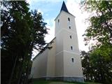
 | Radovljica - Castle Lipniški grad (Pusti grad above Lipnica) (on natural learning trail)
Castle Lipniški grad or Pusti grad above Lipnica (Waldenberg in German) is located on a lookout over the Sava and Lipnica watercourses, more prec...
1 h 20 min |
 | Preval Prosca - Visoki hrib
Visoki hrib is a 602 m high hill located south of Polhov Gradec. The summit, partly covered by forest, offers a beautiful view, especially to the...
50 min |
 | Povir - Stari tabor
Stari tabor is a scenic peak located west of Divača, north of Lokev and south of the village of Povir. From the summit, where the stamp and the r...
1 h 10 min |
 | Povir - Stari tabor (harder path)
Stari tabor is a scenic peak located west of Divača, north of Lokev and south of the village of Povir. From the summit, where the stamp and the r...
1 h 15 min |
 | Ressnig - Aussicht Petelinz
Aussicht Petelinz is located north-east of Borovel / Ferlach and north or directly above the river Drava / Drau. From the lookout point where the...
1 h |
 | Čatež - Bajturn (Zaplaški hrib) (on north slope)
At 609 metres, Bajturn or Zaplaz Hill is the highest peak in the municipality of Trebnje. At the top there is a nice bench with a table, a box wi...
50 min |
 | Zreče (Terme Zreče) - Golika
Golika is a 609-metre-high peak on Brinjeva Gora, on which the Church of St Neže stands....
50 min |
 | Zgornja Slivnica - Pugled
Pugled is a 615m high peak located between Podlipoglav and Veliki Lipoglav. The view from the top of the large NOB monument is limited due to the...
1 h 30 min |
 | Zreče (Terme Zreče) - Brinjeva gora (above Zreče) (via farm Pudgrošek)
Brinjeva gora is a remarkable hill located between Zreče and Oplotnica. Brinjeva gora is famous for its several churches, which are located in a ...
50 min |
 | Zreče (Terme Zreče) - Brinjeva gora (above Zreče) (via Golika)
Brinjeva gora is a remarkable hill located between Zreče and Oplotnica. Brinjeva gora is famous for its several churches, which are located in a ...
1 h |
 | Preval Prosca - Ključ
Ključ is a forested peak located north of Brezje pri Dobrovi and south of Dolenje vas. There is no view from the top where the registration box w...
1 h |
 | Dolenja vas (Kosmulj) - Ključ
Ključ is a forested peak located north of Brezje pri Dobrovi and south of Dolenje vas. There is no view from the top where the registration box w...
1 h 10 min |
 | Sveti Urh - Ključ
Ključ is a forested peak located north of Brezje pri Dobrovi and south of Dolenje vas. There is no view from the top where the registration box w...
1 h |
 | Rašica - Rašica (Vrh Staneta Kosca) (by road)
Vrh Staneta Kosca, better known as Rašica, is located north of Ljubljana, specifically above the village of Rašica and Dobena. From the top of th...
55 min |
| Rašica - Rašica (Vrh Staneta Kosca) (footpath)
Vrh Staneta Kosca, better known as Rašica, is located north of Ljubljana, specifically above the village of Rašica and Dobena. From the top of th...
55 min |
 | Spodnje Dobeno - Rašica (Vrh Staneta Kosca)
Vrh Staneta Kosca, better known as Rašica, is located north of Ljubljana, specifically above the village of Rašica and Dobena. From the top of th...
50 min |
 | Gora - Trstelj
Trstelj is the highest peak in the Black Hills ridge. The view from the vast summit, where the TV transmitters stand, is split in half. From the ...
50 min |
 | Mekinje nad Stično - Sveti Lambert
Sveti Lambert is located on an inconspicuous peak near the village of Pristava above Stično. From the top of the hill, where the castle of the Du...
1 h 5 min |
 | Zazid - Jampršnik
Jampršnik is a little-known and even less visited peak located in the mountain chain southwest of Črni Kalo. Despite its modest height, the summi...
1 h |
 | border crossing Lipica - Kokoš (steep way)
Koča na Kokoši is located at the top of Jirmanec, just 5 minutes away from the forested Kokoša. The summit, located south of the Lokavsko polje a...
50 min |
| border crossing Lipica - Kokoš (by road)
Koča na Kokoši is located at the top of Jirmanec, just 5 minutes away from the forested Kokoša. The summit, located south of the Lokavsko polje a...
1 h |
 | Lipica (Škibini) - Kokoš
Koča na Kokoši is located at the top of Jirmanec, just 5 minutes away from the forested Kokoša. The summit, located south of the Lokavsko polje a...
50 min |
| Lokev - Kokoš
Koča na Kokoši is located at the top of Jirmanec, just 5 minutes away from the forested Kokoša. The summit, located south of the Lokavsko polje a...
1 h 30 min |
 | Krvavi Potok - Kokoš
Koča na Kokoši is located at the top of Jirmanec, just 5 minutes away from the forested Kokoša. The summit, located south of the Lokavsko polje a...
1 h 30 min |
| Prelože pri Lokvi - Kokoš
Koča na Kokoši is located at the top of Jirmanec, just 5 minutes away from the forested Kokoša. The summit, located south of the Lokavsko polje a...
1 h 30 min |
 | Straßengel - Frauenkogel
...
1 h 10 min |
 | Legastja - Sveti Florijan (Tehovec)
The Church of St Florian is a branch church located in the village Tehovec above Medvode. The church, which was first mentioned in 1548, offers a...
50 min |
 | Mekinje nad Stično - Pristava above Stična
Pristava above Stična is a small village located on a scenic hill north of Stična. A little above the village, by the Partisan House, there is a ...
1 h 5 min |
 | Moravče - Gorišca
Gorišca is a 698-metre-high peak located south-west of the Ušte - Žerenk Mountain Lodge. The summit, on which the converter stands, offers no bet...
1 h 15 min |
 | Šober - Tojzlov vrh
Tojzlov vrh is a forested hill located in the eastern part of Kozjak. On the top of the hill stands a small stone monument to the National Libera...
1 h |
| Šober (Log) - Tojzlov vrh
Tojzlov vrh is a forested hill located in the eastern part of Kozjak. On the top of the hill stands a small stone monument to the National Libera...
50 min |
 | Blečji vrh - Gradišče (via Kucelj)
Gradišče is a lesser-known peak located north of Višnja gora. From the top of the hill, where a large cross stands, there is a beautiful view of ...
1 h 30 min |
 | Gorenja vas - Jermanca (Jermancov grič)
Jermanca, on maps Jermanca hill, is a lookout point above Gorenjska vasje. In good weather, the summit offers a beautiful view of the peaks above...
55 min |
 | Preval Prosca - Koreno (gentle path)
Koreno also Koreno is a 729 m high hill located north of Horjul. From the top, where there is a large cross, the Church of St. Mohorj and Fortuna...
1 h 15 min |
 | Preval Prosca - Koreno
Koreno also Koreno is a 729 m high hill located north of Horjul. From the top, where there is a large cross, the Church of St. Mohorj and Fortuna...
1 h |
 | Dobrič - Gora Oljka
Gora Oljka is a hill located east of Šmartno ob Paki. On the top stands the Church of the Holy Cross, which was built in the mid-18th century. Ju...
50 min |
 | Dobrič (Vedet) - Gora Oljka (via Brezovec)
Gora Oljka is a hill located east of Šmartno ob Paki. On the top stands the Church of the Holy Cross, which was built in the mid-18th century. Ju...
50 min |
 | Hrpelje - Hrpeljska gora
Hrpeljska gora or Mišja šoga is a 737m high peak located south of Hrpelje. The partially vegetated peak offers a beautiful view of the surroundin...
1 h 30 min |
 | Velesovo - Apnišče (via Šterna)
Apnišče is a 740 m high mountain located between Možjanca and Štefanja gora. It is the highest point of the Šenčur municipality. There is a bench...
1 h 10 min |
 | Krvavi Potok - Veliko Gradišče
Veliko Gradišče is a 742 m high peak located south of the village of Lokev in the Karst and east of Kokoši. From the top, on which stands a concr...
1 h |
 | Adergas - Štefanja gora (via benches)
Štefanja gora on which the Church of St Stephen stands, is located above Cerkly in Gorenjska. Just 10 metres below the summit, the Pr'Mežnarju ex...
1 h |
 | Adergas - Štefanja gora (via šterna)
Štefanja gora on which the Church of St Stephen stands, is located above Cerkly in Gorenjska. Just 10 metres below the summit, the Pr'Mežnarju ex...
1 h |
 | Olševek - Štefanja gora
Štefanja gora on which the Church of St Stephen stands, is located above Cerkly in Gorenjska. Just 10 metres below the summit, the Pr'Mežnarju ex...
55 min |
 | Velesovo - Štefanja gora (via benches)
Štefanja gora on which the Church of St Stephen stands, is located above Cerkly in Gorenjska. Just 10 metres below the summit, the Pr'Mežnarju ex...
1 h 10 min |
| Velesovo - Štefanja gora (via Šterna)
Štefanja gora on which the Church of St Stephen stands, is located above Cerkly in Gorenjska. Just 10 metres below the summit, the Pr'Mežnarju ex...
1 h 10 min |
 | Pivka - Šilentabor
Šilentabor is a 751 m high peak located just above the village of the same name. From the top, near which there is also a bench and a registratio...
1 h 30 min |
| Narin - Šilentabor
Šilentabor is a 751 m high peak located just above the village of the same name. From the top, near which there is also a bench and a registratio...
1 h |
 | Krnice - Dom v Gorah
The mountain lodge in Gora is located east of Hrastnik, just a few metres below the 786m-high peak on which the Church of St George stands. From ...
1 h 5 min |
 | Leskovec - Obolno
Obolno is a 776m high peak located south-west of the village of the same name. The grassy summit, next to which the radio club hut stands, offers...
1 h |
 | Veliko Trebeljevo - Obolno
Obolno is a 776m high peak located south-west of the village of the same name. The grassy summit, next to which the radio club hut stands, offers...
1 h 20 min |
 | Mala Goričica - Obolno
Obolno is a 776m high peak located south-west of the village of the same name. The grassy summit, next to which the radio club hut stands, offers...
1 h 10 min |
| Mala Goričica - Obolno (by road)
Obolno is a 776m high peak located south-west of the village of the same name. The grassy summit, next to which the radio club hut stands, offers...
1 h 15 min |
 | Podpeč - Kamen vrh
Kamen vrh is a scenic peak located on the northern outskirts of Mala Gora. From the top, surrounded by low bushes, there is a beautiful view of p...
50 min |
 | Velike Lašče - Kamen vrh
Kamen vrh is a scenic peak located on the northern outskirts of Mala Gora. From the top, surrounded by low bushes, there is a beautiful view of p...
1 h 15 min |
 | Ljubljanica - Sveti Andrej (Planina above Horjul)
The Church of St Andrew is situated on a lookout hill just above the Mountain pasture above Horjul. The church, which was built in 1659, offers a...
1 h 15 min |
 | Kuren - Ulovka
Ulovka is the peak between Zaplana and the Shelter at Mountain pasture above Vrhnika. From the top, which is reached by ski lifts, there is a nic...
50 min |
 | Podgorje - Kojnik (steep path)
Kojnik is a partially vegetated peak located in the southern part of the Podgorje Karst near the Slovenian-Croatian border. From the top of the s...
1 h |
 | Mislinja - Sveti Vid (Završe)
The Church of St.Vid, which has a small cemetery, is located in the middle of the scattered settlement of Završe. From the church, or its immedia...
1 h 10 min |
 | Kambreško - Globočak
Globočak is an 809 m high peak located in the Kanalski Kolovrat mountain range. The summit, which contains some remnants of the First World War, ...
50 min |
 | Hotedršica - Medvedje Brdo
Medvedje Brdo is a small settlement located north of Hotedršice. The highest point of the village is a pleasant lookout point located on Šinkovco...
1 h 15 min |
 | Rovte - Medvedje Brdo (via Kamnikov Grič)
Medvedje Brdo is a small settlement located north of Hotedršice. The highest point of the village is a pleasant lookout point located on Šinkovco...
1 h 15 min |
 | Mislinja - Sveti Rupert (Završe)
St Rupert's Church is situated on a viewpoint, just south of the Frice Hill. From the church or its immediate surroundings, in fine weather, we h...
1 h 25 min |
 | Pivka - Osojnica
Osojnica is a forested hill located west of Pivka. There is no view from the top, which has a registration box, a stamp and a bench....
1 h |
 | Mislinja - Časov vrh
Časov vrh (also called Časkov vrh on some maps) is a less distinct hill located between Fričev vrh and Črepič. As the peak is forested, there is ...
1 h 15 min |
 | Praproče - Polhograjska Gora (Sveti Lovrenc) (gentle path)
Polhograjska Gora, also just Gora or Sveti Lovrenc, is an 824 m high hill located north-west of Polhov Gradec. From the top of the hill, where th...
50 min |
 | Kropa - Sveti Primož in Felicijan (Jamnik)
The Church of St. Primož and Felicijan on Jamnik, is situated on a scenic grassy ridge rising between Kropa and Podblica. From the church or its ...
1 h 10 min |
 | Podjuna / Jaunstein - Gora sv. Eme (Junska gora) / Hemmaberg (umik zaprti poti)
Gora sv. Eme is located south of the village of Podjuna / Jaunstein. The Church of St. Emma (Hema) Krška stands on the top and the ruins of forme...
55 min |
| Globasnica / Globasnitz - Gora sv. Eme (Junska gora) / Hemmaberg
Gora sv. Eme is located south of the village of Podjuna / Jaunstein. The Church of St. Emma (Hema) Krška stands on the top and the ruins of forme...
55 min |
 | Pševo - Sveti Jošt above Kranj (Sodarjeva pot, past the chapel)
Sveti Jošt above Kranj, is a hill located to the west of the slightly lower Šmarjetna Gora. From the top, where the Church of St. Jošto and the J...
50 min |
 | Ledinsko Razpotje - Sveta Marija Magdalena (Gore) (east path)
The Church of St Mary Magdalene is situated on a hill above the settlement Gore, which is above Idrija. From the church or its immediate surround...
1 h |
| Ledinsko Razpotje - Sveta Marija Magdalena (Gore) (west path)
The Church of St Mary Magdalene is situated on a hill above the settlement Gore, which is above Idrija. From the church or its immediate surround...
1 h 10 min |
 | Bločice - Križna gora
Križna gora is a partially overloked peak located above the village of Sveta Ana and Podlož. From the top of the hill on which the Church of the ...
1 h 15 min |
 | Sv. Andrej - Sveti Ožbolt (above Zminec)
Sveti Ožbolt is located on a scenic peak in the north of the Polhograjske Dolomites. It has a beautiful view of the Škofjeloško hribovje and part...
1 h |
 | Škalske Cirkovce - Stropnik
...
1 h |
 | Tržič (Slap) - Kamnek (via Ride)
Kamnek (Kamnik on maps, but also Kamnjek) is a scenic peak above Tržič....
55 min |
 | GEOSS - Slivna (Pivkelj)
Slivna or Pivkelj (also Pivkelj turn) as this peak is also called is located south of Limbarska Gora. Pivkelj is also the highest point of the Mo...
1 h |
 | Rebrca / Rechberg - Rokov vrh / Rochusberg (via Bukovnik)
Rokov vrh is an 880 m high peak (according to some data 817 m) located between the settlements of Suha / Zauchen, Rebrca / Rechberg and Podkraj /...
1 h |
 | Škalske Cirkovce - Stropnica (čez Stropnik)
...
1 h 10 min |
 | Škalske Cirkovce - Stropnica
...
1 h |
 | Sopot - Vrh Svetih Treh Kraljev
The Church of the Holy Three Kings is situated on a lookout above the village of Vrh Svetih Treh kraljev. From the top, which has an observation ...
1 h 25 min |