 | Kališe - Kranjska reber
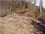
Kranjska reber or Peak Kašna planina (1435 m) is a volcanic mountain. From the top, where the registration box with the stamp is located, we have...
1 h 30 min |
| Volovljek - Kranjska reber (on unmarked path)
Kranjska reber or Peak Kašna planina (1435 m) is a volcanic mountain. From the top, where the registration box with the stamp is located, we have...
1 h 15 min |
 | Kajfežev rob - Kamniški vrh
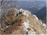
Kamniški vrh is a 1259 m high mountain located north of Kamnik, between Stahovica and the Korošica Valley. From the top of the peak there is a sm...
1 h 15 min |
 | Brezje pri Tržiču - Vaško
Vaško is a little-known mountain in the south-eastern ridge of Dobrča. From the top there is a beautiful view towards Jelovica and the Julian Alp...
55 min |
 | Brezje pri Tržiču - Vaško (eastern path)
Vaško is a little-known mountain in the south-eastern ridge of Dobrča. From the top there is a beautiful view towards Jelovica and the Julian Alp...
1 h 5 min |
| Water storage Žegnani studenec - Vaško
Vaško is a little-known mountain in the south-eastern ridge of Dobrča. From the top there is a beautiful view towards Jelovica and the Julian Alp...
1 h 5 min |
 | Dom na Lazni - Stanov rob
A crest above Gorenja Trebuša, with a beautiful view....
1 h 10 min |
 | Cenc - Špičasti vrh (on road over Novina)
Špičasti vrh is a forested mountain located south of the village of Zadlog. To ensure that the peak is not without a view, a 13m high wooden look...
1 h 30 min |
 | Dom Pristava in Javorniški Rovt - Španov vrh
Španov vrh is a 1334m high mountain located between Javorniški Rovt and Mountain pasture below Golica. From the top, reached by the cable car of ...
1 h 30 min |
| Planina pod Golico - Španov vrh
Španov vrh is a 1334m high mountain located between Javorniški Rovt and Mountain pasture below Golica. From the top, reached by the cable car of ...
1 h 15 min |
 | Planina Lom - Kobilja glava
Kobilja glava is a 1475 m high peak located east of Tolmin. From the top with a cross, we have a beautiful view of the Krn, the Lower Bohinj Moun...
1 h 15 min |
 | Koča na planini Stador - Jalovnik
Jalovnik is a grassy peak located southeast of the slightly higher Kobilje glave. From the summit, which has a registration box, we have a beauti...
1 h 30 min |
| Planina Lom - Jalovnik
Jalovnik is a grassy peak located southeast of the slightly higher Kobilje glave. From the summit, which has a registration box, we have a beauti...
1 h 30 min |
 | Oblakov Vrh - Hudournik
Hudournik is a 1148 m high peak located on the northern edge of the Vojskar plateau, a plateau situated between the valleys of the Idrijca, Kanom...
1 h 30 min |
 | Koča na planini Kuhinja - Planica below Krn
Planica is a 1376 m high peak located south-west of Kren. The overgrown peak, which has two peaks of approximately the same height, offers a beau...
1 h 15 min |
 | Bodental - Požgani rob
Požgani rob is a 1513 m high mountain located north of Rjavka. The summit is surrounded by forest, so there is no better view, but we have a nice...
1 h 10 min |
 | Matevljek - Petelinjek
Petelinjek is a 1212 m high peak located in the Racna Gora mountain range. There is no view from the summit, which is topped by a small metal cha...
1 h 15 min |
 | Pri Žagi (Javorniški Rovt) - Velika Boncla
Velika Boncla is a 1241 m high, partly rocky peak located between Javorniški Rovt and mountain pasture Stamare in the Karavanke Mountains. The st...
1 h |
 | Rotek - Erbelc
Erbelc is a 1308-metre-high peak rising steeply above Zgornja Sorica. From the summit, where the registration box is located, you can enjoy a bea...
1 h 15 min |
| Spodnje Danje - Erbelc
Erbelc is a 1308-metre-high peak rising steeply above Zgornja Sorica. From the summit, where the registration box is located, you can enjoy a bea...
1 h 15 min |
 | Rotek - Tonderškofel
Tonderškofel is a 1326-metre high peak located between Soriška Peć and Erbellec. The partly overgrown peak, which has no marked trail, offers a b...
1 h 15 min |
| Spodnje Danje - Tonderškofel
Tonderškofel is a 1326-metre high peak located between Soriška Peć and Erbellec. The partly overgrown peak, which has no marked trail, offers a b...
1 h 15 min |
 | Jeršiče - Baba (at Javorniki)
Baba is a 1085 m high peak located between the Javorniki Ridge and Sveta Trojica. From the grassy summit, we have a beautiful view of the Javorni...
1 h 30 min |
 | Planina pod Golico - Na pečeh pri Črnem Vrhu
On the Peaks is a lesser-known lookout peak with an altitude of 1318 metres, rising east above the village Mountain pasture below Kahlkogel. In t...
1 h 5 min |
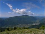
 | Možjanca - Kopa (Partizanski vrh)
Kopa, also Partizanski vrh, is a 1024-metre high mountain located west of the Davovec saddle, which is west to south-west of Krvavec. There is a ...
1 h 30 min |
 | Bele Vode (Kovač) - Sveti Križ above Bele Vode (on south ridge)
Sveti Križ is a scenic mountain located above Beli Voda. From the top, which is home to a number of church buildings and a conversion tower, we h...
1 h 10 min |
 | Tolminske Ravne - Javor (above Tolminske Ravne)
Javor is a 1363 m high peak located between Tolminske Ravne and Grušnica. From the top, on which a small cross is erected, you can enjoy a beauti...
1 h 20 min |
 | Bela Peč - Ojstri vrh (above Prevala) (past peak Seduc)
Ojstri vrh is a 1,197-metre-high mountain located between Seduc Peak and Prevala. From the top, you can enjoy a beautiful view of the surrounding...
1 h 30 min |
 | Poljšica pri Gorjah (Zatrata) - Hotunjski vrh (on footpath)
Hotunjski vrh is a 1107-metre-high lookout peak located above the Zatrnik ski resort. From the top, where there is a registration box and a bench...
1 h 30 min |
 | Topla (Končnik) - Šoparjev vrh
Šoparjev vrh is a 1524 m high mountain located between Olševa and Peca, more precisely on the ridge that separates the Koprivna valley from the T...
1 h 15 min |
 | Sveta Jedert (Lajše) - Bela peč (Podbliška gora) (via Rigli)
Bela peč is located on the edge of Jelovica above the village of Podblica. From the top of the cliff we have a beautiful view of the village, the...
1 h 30 min |
| Sveta Jedert (Lajše) - Bela peč (Podbliška gora) (upper part on the road)
Bela peč is located on the edge of Jelovica above the village of Podblica. From the top of the cliff we have a beautiful view of the village, the...
1 h 30 min |
 | Završnica (Pri žagi) - Tolsti vrh (at Poljška planina) (via saddle Kališča)
Tolsti vrh is a 1,225-metre-high peak located between the Završnice valley and the Draga valley. The peak is located in a forest, but from the lo...
1 h 25 min |
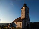 | Koprivna (Šumel) - Sveti Jakob in Koprivna
The Church of St James in Koprivna is situated on a lookout hill above the right bank of the Mež River. The church offers a beautiful view of Rad...
50 min |
 | Žabnica / Bodental - Veronjak / Hausberg
Veronjak is a 1348 m high peak located above the Poden / Bodental valley on the Austrian side of the Karavanke. From the top, where there is a sm...
1 h 20 min |
| Slovenji Plajberk / Windisch Bleiberg - Veronjak / Hausberg (via Veronjak / Hausberg)
Veronjak is a 1348 m high peak located above the Poden / Bodental valley on the Austrian side of the Karavanke. From the top, where there is a sm...
1 h 25 min |
 | Medvodje - Medvodnica (via Tržiška Bistrica)
Medvodnica is a 1202 metre high mountain located between the Košutna and Tržiška Bistrica watercourses. The peak is located in a forest, so there...
1 h 30 min |
| Medvodje - Medvodnica (via Košutnik)
Medvodnica is a 1202 metre high mountain located between the Košutna and Tržiška Bistrica watercourses. The peak is located in a forest, so there...
1 h 25 min |
 | Erjavčev rovt - Bela peč (above Dovje)
Bele peči is a less known peak, located above the marked Dovje - Dovška Baba trail. The summit offers a beautiful view to the south and west, whi...
1 h 15 min |
 | Dovje - Blažčeva skala (western path)
Blažčeva skala is a 1091-metre-high peak located north-east of Mojstrana and Dovje. From the top, which is known more by climbers than mountainee...
1 h |
 | 2. serpentina vršiške ceste - Škrbinjek
...
1 h |
 | Straßegg - Zechnerschlag (Rohregg)
...
1 h 30 min |