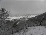
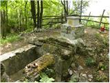
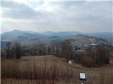
 | Rovišče - Zasavska Sveta gora (by road)
Zasavska Sveta gora is a popular excursion point located between Litija and Izlaki. From the top, where the parish church of the Nativity of the ...
35 min |
 | Praproče - Mali vrh
To the west of Polhov Gradec, between the rivers Mala voda and Velika Božna, is a 708-metre-high hill called Mali vrh. From the grassy summit, wh...
35 min |
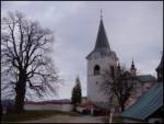
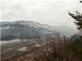
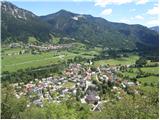
 | Križna Gora - Archangel Gabriel (Planica)
Planica is an 824 m high peak located north of Škofja Loka, between Krizna Gora and Planica. From the top, where the Church of St. Gabriel the Ar...
35 min |
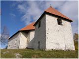 | Veliki Ločnik - Sveti Ahac
The Sveti Ahac church is located on a peak called Gora above the villages of Mali and Veliki Ločnik near Turjak. From the top, which has a regist...
30 min |
 | Lanišče - Janče
Janče is a 792-metre-high peak located between the Sava River and the valley of the Besnica Stream. From the top, where the mountain lodge stands...
30 min |
 | Velika vrata - Mala Plešivica
Mala Plešivica, which is higher than the neighbouring Velika Plešivica, is a scenic peak located to the west of the village of Golac on the borde...
35 min |
 | Velika vrata - Velika Plešivica
Velika Plešivica is a 908 m high peak located between Slavnik and the less known Mala Plešivica. From the top of the summit, where the destroyed ...
25 min |
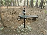
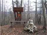
 | Zgornja Javoršica - Murovica
Murovica is a popular excursion point, accessible from the Posavina side, Domžale or from the Moravška valley. There is a bench and a registratio...
25 min |
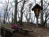
 | Jesenice (Ukova) - Kalvarija above Jesenice
Calvary is a popular point or peak above the town of Jesenice, known either as a kind of short "pilgrimage" route for the faithful, or as a short...
25 min |
 | Begunje - Goli vrh (Cemarovnik)
Goli vrh or Begunjski Cemarovnik is an 816 m high mountain located in the south-eastern part of Menišija. From the top, on which stands a large c...
30 min |
 | Suhi Dol - Sveti Andrej (Planina above Horjul)
The Church of St Andrew is situated on a lookout hill just above the Mountain pasture above Horjul. The church, which was built in 1659, offers a...
25 min |
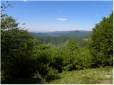
 | Dom na Govejku - Gontarska planina
Gontarska planina is an 894 m high mountain located between Osolnik and Tosce. From the top, where there are two benches, we have a beautiful vie...
35 min |
 | Rakitna - Rotovc
Rotovc is a 964 m high peak located northeast of Rakitna. From the top, where a wooden bench stands, we have a beautiful view towards the already...
30 min |
 | Trebež (Jesenice) - Kozjek (on east ridge)
Kozjek is a 766 m high, easily accessible, ridge-like peak of the Jelenkamn fothills, which makes it part of the southern Karavanke fothills, and...
30 min |
 | Hunting sports association Vinska Gora - Temnjak
Temnjak (on some maps also written Vinska gora, but this is a neighbouring hill) is a 798 m high peak located north of the village Prelska near V...
25 min |
 | Planinski dom pod Ježo - Ježa
Ježa is a 949 m high peak located west of Volč, on the slopes of Kolovrat. From the top, where there is a registration box with a registration bo...
30 min |
 | Srednje - Globočak
Globočak is an 809 m high peak located in the Kanalski Kolovrat mountain range. The summit, which contains some remnants of the First World War, ...
35 min |
 | Mojstrana - Grančišče (south path)
Grančišče (also Grančiše) is a small precipitous peak rising west to south-west of Mojstrana. From the top, where there is a bench and a table, w...
25 min |
 | Pivka - Primož
Primož is a 718 m high peak located south to south-east of Pivka. Due to its ideal location overloking the entire Pivka basin, the Italians built...
25 min |
 | Zagorje - Šilentabor
Šilentabor is a 751 m high peak located just above the village of the same name. From the top, near which there is also a bench and a registratio...
35 min |
 | Žusem Castle - Žusem
Žusem is a 669-metre-high hill with a colourful history and great potential for the future. It represents the northern edge of the Kozjansko regi...
30 min |
 | Travnarjev gozd (Hotenjsko podolje) - Sveta Barbara (Ravnik pri Hotedršici)
The Church of St Barbara is situated on a hill overloking the village of Ravnik near Hotedršice. From the church or its immediate surroundings, w...
35 min |
 | Možjanca - Apnišče
Apnišče is a 740 m high mountain located between Možjanca and Štefanja gora. It is the highest point of the Šenčur municipality. There is a bench...
35 min |
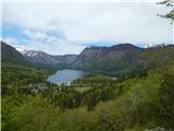 | Jezersko polje - Peč (viewpoint)
The viewpoint is located 50 metres lower than the 720-metre-high Peči, the peak that separates the Lower Bohinj Valley from the Upper Bohinj Vall...
35 min |
 | Škalske Cirkovce - Skalni vrh (Vodemla)
Skalni vrh is the highest peak of Vodemla Hill, rising above Paka pri Velenju on one side and the Velenje basin on the other. On the way along th...
35 min |
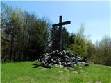
 | border crossing Remšnik - Sveti Pankracij (Radelca)
The Church of St Pancras on Radelca is located on the border ridge between Slovenia and Austria, but since 1966, following an inter-state agreeme...
25 min |
 | Žiri - Goropeški grič (Pikrej)
Goropeški grič, or Pikrej as this peak is also called, is located south of Žiri. From the meadows near the registration box, we have a beautiful ...
30 min |
 | Planina pri Sevnici - Sveti Križ (above Planina pri Sevnici) (via Pravljični gozd)
The Church of the Holy Cross is located above Planina pri Sevnici, near the settlement of Šentvid at Mountain pasture. From the top, you have a b...
28 min |
| Planina pri Sevnici - Sveti Križ (above Planina pri Sevnici)
The Church of the Holy Cross is located above Planina pri Sevnici, near the settlement of Šentvid at Mountain pasture. From the top, you have a b...
23 min |
 | Waldgebiet - Großer Hirschenstein
...
30 min |
 | Cesta na Bjelsko - Stožac
...
30 min |