 | Preval - Toško Čelo
Toško Čelo is a 590-metre hill above the village of the same name. From the summit, or slightly below it, a beautiful view opens over part of Lju...
35 min |
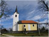
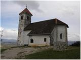 | Jezero - Sveta Ana
The Church of St. Ana is situated on a small panoramic hill above Jezero, Podpeč, and Preserje. From the top, which has a panorama board, a nice ...
30 min |
 | Vrtovin - Školj Svetega Pavla above Vrtovin
Školj sv. Pavla is located on a panoramic hill above the village of Vrtovin, which lies west of Ajdovščina. From the church, near which the logbo...
35 min |
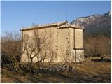
 | Zabukovica (Podvine) - Dom na Bukovici
The mountain hut Dom na Bukovici is situated just a few meters below the summit of the forested Bukovica. From the hut, near which there is a lar...
25 min |
 | Matke (Zahom) - Dragov dom na Homu
Dragov dom is located on a scenic hill south of Šempeter. From the summit, where there is also the Church of St. Magdalena, there is a fine panor...
35 min |
 | Železna vrata - Trstelj
Trstelj is the highest peak in the ridge of Črni hribi. From the spacious summit, which has TV transmitters, the view is divided. From the north ...
35 min |
 | Slovenske Konjice - Konjice Castle
Konjice Castle (Konjiški Stari grad), built in the 12th century, is one of the oldest castles in Slovenia. From the castle, which is slowly being...
30 min |
 | Bizeljska vas - Svete gore
Svete gore (527 m) is a hill in the Orlica range, located at the far eastern end of Posavsko hribovje. Its summit, with five church buildings, is...
30 min |
| Bizeljska vas - Svete gore (by road)
Svete gore (527 m) is a hill in the Orlica range, located at the far eastern end of Posavsko hribovje. Its summit, with five church buildings, is...
30 min |
 | Pristavlja vas - Lavričeva koča on Gradišče
Lavričeva koča (510 m) is located just a few meters below the summit of Gradišče (519 m), where the Church of St. Nicholas stands. From the summi...
30 min |
 | Gaber pri Semiču - Semenič
Semenič is a 590-meter-high, forest-covered peak located southwest of the better-known Smuk above Semič. A castle from the 12th century once stoo...
30 min |
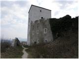
 | Kamnik - Castle Stari grad Kamnik
Stari grad Kamnik, formerly known as Zgornji grad (Oberstain), is located on a scenic hill east of Kamnik called Krniška gora. Today, only ruins ...
35 min |
 | Žusem Castle - Žusem
Žusem is a 669-meter-high hill with a rich history and great potential for the future. It forms the northern edge of Kozjansko, and its name deri...
30 min |
 | Travnarjev gozd (Hotenjsko podolje) - Sveta Barbara (Ravnik pri Hotedršici)
The Church of St. Barbara is located on a panoramic rise above the settlement of Ravnik pri Hotedršici. From the church or its immediate surround...
35 min |
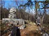 | Prevala - Veliki hrib (survey point 526)
Veliki hrib, or kota 526 (the latter mainly associated with World War I; also Mali vrh on some maps), is a peak located northwest of Škabrijel, w...
35 min |
 | Pečar - Žagarski vrh
Žagarski vrh is situated on the ridge between Podlipoglav and Besnica. From the summit, where there is the amateur radio operators' hut, there is...
35 min |
 | Žiri - Goropeški grič (Pikrej)
Goropeški grič, also known as Pikrej, is located south of Žiri. From the meadows near the logbook box, a nice view opens up onto the surrounding ...
30 min |
 | Gorenja Dobrava - Sveti Urban (above Gorenja Dobrava)
The Church of St. Urban is located on a hill between Gorenja Dobrava and Todraž. From the summit, where there is a summit register box with a log...
25 min |
 | Bad Gleichenberg (Eichgraben Weg) - Mühlsteinbruch
Mühlsteinbruch lies north to northeast of Bad Gleichenberg. A cross stands on the summit, with the Edelweißwarte lookout tower and Enzian Hütte h...
35 min |