Starting point: Grad Žusem (502 m)
| Latitude/Longitude: | 46,16033°N 15,48691°E |
| |
Walking time: 30 min
Difficulty: easy marked way
Elevation gain: 167 m
Elevation difference along the route: 167 m
Map:
Recommended equipment (summer):
Recommended equipment (winter):
Views: 4.970
 | 1 person like this post |
Access to starting point:
From Celje, we drive towards Teharje and Rogaška Slatina. When we come through Teharje, in the roundabout we go towards Štore and Zagreb. We drive through Štore to Šentjur. In Šentjur at the last traffic-light intersection we go towards Planina pri Sevnici. We drive across the railway track and at the end after the sign Šentjur, where the settlement ends, we turn towards Gorica pri Slivnici. We drive uphill a few kilometers to this settlement. There we go towards Sodna vas. We drive past Slivnica Lake, which we see on the left side of the road. After a few kilometers on the right, we notice signs for Žusem and for a quarry. We turn to the right, and then uphill past the quarry. After a few meters, we see ruins of Žusem castle. We park there.
Route description:
From the Žusem castle, we go right uphill on the asphalt road. After a few 100 meters, we notice signposts towards the summit Žusem and Stolp ljubezni (love tower). From the road, we turn off to the right on a forest path, which goes immediately left uphill. The path is quite steep and winding. It is well marked. It brings us to the fence of the quarry. There are warning signs that passing the fence is forbidden. We continue on a marked path, which brings us to a macadam road. We cross this road and we again step on a hiking forest path. On the tree, we notice a notification about mining in the quarry. On the path, there are enough blazes, which soon lead us to the summit.
There are the mountain hut and Stolp ljubezni (love tower). Below the tower there is an inscription book, and the stamp is supposedly in the cottage.
Along the route: Kamnolom Žusem (650m)
Photos:
 1
1 2
2 3
3 4
4 5
5 6
6 7
7 8
8 9
9 10
10 11
11 12
12 13
13 14
14 15
15 16
16 17
17 18
18 19
19 20
20 21
21 22
22 23
23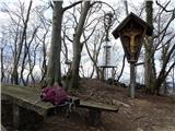 24
24
Discussion about the trip Grad Žusem - Žusem
|
| plaNinaPirsMajcen26. 06. 2025 18:53:33 |
Hi, I recorded a short video from this path.
https://youtu.be/FpNOXzqysrI?si=iqgmwruStKwxJdCc
I explored the ruins of the castle, continued along the secured path to Stolp ljubezni and returned via the easy path.
The easy path described above is a fun short hike, also suitable for children.
Best, Nina
|
|
|
To post a comment you must log in:
If you do not yet have a username, you must first
register.