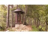
 | Kranj-Stražišče (Šrotenturn) - Šmarjetna gora (east path)
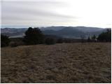
Šmarjetna gora is a scenic peak rising above Kranj. From the top, where the Church of St. Margaret and the Bellevue Hotel stand, we have a beauti...
45 min |
 | Kranj-Stražišče (Šrotenturn) - Šmarjetna gora (west path)
Šmarjetna gora is a scenic peak rising above Kranj. From the top, where the Church of St. Margaret and the Bellevue Hotel stand, we have a beauti...
40 min |
| Kranj-Stražišče (Šrotenturn) - Šmarjetna gora (by cart track)
Šmarjetna gora is a scenic peak rising above Kranj. From the top, where the Church of St. Margaret and the Bellevue Hotel stand, we have a beauti...
45 min |
 | Tičnica - Šmarjetna gora
Šmarjetna gora is a scenic peak rising above Kranj. From the top, where the Church of St. Margaret and the Bellevue Hotel stand, we have a beauti...
50 min |
 | Gradec - Osojnica
Osojnica is a forested hill located west of Pivka. There is no view from the top, which has a registration box, a stamp and a bench....
45 min |
 | Dobrič (Vedet) - Gora Oljka (by road)
Gora Oljka is a hill located east of Šmartno ob Paki. On the top stands the Church of the Holy Cross, which was built in the mid-18th century. Ju...
50 min |
 | Pogorelec - Sedlata gorica (Pogorelec)
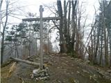
Sedlata gorica is a peak above the village Podturn near Dolenjske Toplice. The peak used to be overgrown, but nowadays there is a hill on the top...
45 min |
 | Tone Čufar square (Jesenice) - Kalvarija above Jesenice (steep path)
Calvary is a popular point or peak above the town of Jesenice, known either as a kind of short "pilgrimage" route for the faithful, or as a short...
35 min |
 | Koroška Bela - Malnež
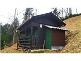
Malnež is an 846 m high lookout peak of the southern Karavanke mountain range, located on the eastern side of the valley in which the village Kor...
40 min |
 | Poljana (Završnica) - Sveti Lovrenc above Zabreznica (via Mali vrh)
Sveti Lovrenc is a lookout point with a church of the same name, located on the southern slope of Grebenc Breznik Ovens, 180 metres above the vil...
1 h |
 | Podblica - Sveti Primož in Felicijan (Jamnik)
The Church of St. Primož and Felicijan on Jamnik, is situated on a scenic grassy ridge rising between Kropa and Podblica. From the church or its ...
50 min |
 | Zgornja Besnica (Nova vas) - Rovnik (west path)
Rovnik is a 707 m high peak located west of Zgornja Besnica. There is no better view from the top, where there are two benches, a wishing bell an...
40 min |
 | Zgornja Besnica (Nova vas) - Rovnik (east path)
Rovnik is a 707 m high peak located west of Zgornja Besnica. There is no better view from the top, where there are two benches, a wishing bell an...
45 min |
 | Grad Hošperk - Stari grad
The Old Castle is a 703 m high peak located between Mountain pasture and Uncem. From the summit, where the transmitters are located, the forest a...
40 min |
 | Šembije - Vrh
Vrh is a 777 m high peak located north of Šembije and south-west of Knežak. The grassy peak, surrounded by individual shrubs, offers a beautiful ...
45 min |
 | Činžat - Lobnikov vrh
Lobnikov vrh is a forested peak above the Drava Valley, situated between Fala and Ruta. From the east, it loks like a solitary rock due to its di...
1 h |
 | Čepovan (Želinc) - Vrh Skopice
Vrh Skopice is a scenic peak located between the Čepovan valley, the Idrijca valley and the Trebuščice valley. From the top, where there is a reg...
50 min |
 | Povlje - Gradišče (Pustinjak)
Gradišče or Pustinjak (also Gradišče above Bašlje) is an 871-metre-high peak located above the Belica stream, which in turn is below the 2132-met...
1 h |
 | Olševek - Apnišče (west path)
Apnišče is a 740 m high mountain located between Možjanca and Štefanja gora. It is the highest point of the Šenčur municipality. There is a bench...
55 min |
 | Olševek - Apnišče (via Šterna)
Apnišče is a 740 m high mountain located between Možjanca and Štefanja gora. It is the highest point of the Šenčur municipality. There is a bench...
55 min |
| Adergas - Apnišče (via Šterna)
Apnišče is a 740 m high mountain located between Možjanca and Štefanja gora. It is the highest point of the Šenčur municipality. There is a bench...
1 h |
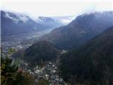
 | Podhom - Hom at Bled
Hom is an 834 m high hill that rises north above the villages Zasip and Podhom near Bled, or south of the village Blejska Dobrava near Jesenice. ...
40 min |
 | Kočna - Vrše (by ski slope)
The 850 m high hill Vrše, across which the TNP boundary runs, rises south-west above the village Blejska Dobrava, or east of the settlement Kočna...
45 min |
 | Kočna - Vrše (čez senožeti)
The 850 m high hill Vrše, across which the TNP boundary runs, rises south-west above the village Blejska Dobrava, or east of the settlement Kočna...
50 min |
 | Rodik - Ajdovščina
Ajdovščina is an 804 metre high peak located above Rodik and Slopes. Today, a metal container stands on the vegetated summit, and the ruins of th...
40 min |
 | Železniki - Hujska (via Kres)
Hujska is a 706-metre-high peak located above Železniki, more precisely between the Dašnjica and Češnjica streams. On the top there is a bench, a...
45 min |
| Železniki - Hujska
Hujska is a 706-metre-high peak located above Železniki, more precisely between the Dašnjica and Češnjica streams. On the top there is a bench, a...
40 min |
 | Škalske Cirkovce - Smodivnik
Smodivnik is a less visited hill, rising above the Hude hole basin at Dolič on one side and the Velenje basin on the other.There is no summit mar...
45 min |
 | Prevalje - Brinjeva gora (above Prevalje) (via Stations of the Cross)
Brinjeva gora is a popular excursion spot for Prevalj inhabitants, located between the Meža River and the Zelenbreški brok. At the top of the hil...
1 h |
| Prevalje - Brinjeva gora (above Prevalje) (south path)
Brinjeva gora is a popular excursion spot for Prevalj inhabitants, located between the Meža River and the Zelenbreški brok. At the top of the hil...
1 h |
 | Mežica - Štalekarjev vrh (on ski slope)
Štalekarjev vrh is a hill above the former Mežica ski resort. There is no better view from the top, but there is a nice view from the grassy area...
45 min |
 | Lovrenc na Pohorju (cemetery) - Koglerjev vrh
Koglerjev vrh is a 698-metre-high, forested peak located south-west of the Šlaus-Kogler organic farm, which is above the village of Lovrenc na Po...
45 min |
| Lovrenc na Pohorju (cemetery) - Koglerjev vrh (via Hožičev vrh)
Koglerjev vrh is a 698-metre-high, forested peak located south-west of the Šlaus-Kogler organic farm, which is above the village of Lovrenc na Po...
1 h |
 | Slovenj Gradec - Rahtelov vrh (eastern path)
...
45 min |
| Slovenj Gradec - Rahtelov vrh (southeastern path)
...
45 min |