 | Dom na Gospincu - Veliki Zvoh
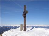
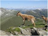
Veliki Zvoh is the highest point of the Krvavec ski resort. The cable car does not quite reach the top, missing only a few metres. A few metres b...
1 h 25 min |
| Kriška planina - Veliki Zvoh
Veliki Zvoh is the highest point of the Krvavec ski resort. The cable car does not quite reach the top, missing only a few metres. A few metres b...
1 h 25 min |
 | Planina Jezerca - Veliki Zvoh (via Dom na Krvavcu)
Veliki Zvoh is the highest point of the Krvavec ski resort. The cable car does not quite reach the top, missing only a few metres. A few metres b...
1 h 40 min |
 | Snežniška Grda jama - Snežnik (via Mali Snežnik)
Snežnik or Veliki Snežnik is the highest peak in the near and far surroundings, at 1796 m. It offers a beautiful view over most of Slovenia and n...
1 h 25 min |
 | Gašperjev hrib - Snežnik
Snežnik or Veliki Snežnik is the highest peak in the near and far surroundings, at 1796 m. It offers a beautiful view over most of Slovenia and n...
1 h 30 min |
 | Gašperjev hrib - Snežnik
Snežnik or Veliki Snežnik is the highest peak in the near and far surroundings, at 1796 m. It offers a beautiful view over most of Slovenia and n...
1 h 30 min |
 | Sviščaki - Snežnik (variant through forest)
Snežnik or Veliki Snežnik is the highest peak in the near and far surroundings, at 1796 m. It offers a beautiful view over most of Slovenia and n...
2 h |
| Sežanje - Snežnik
Snežnik or Veliki Snežnik is the highest peak in the near and far surroundings, at 1796 m. It offers a beautiful view over most of Slovenia and n...
1 h 40 min |
 | Sviščaki - Snežnik (by road)
Snežnik or Veliki Snežnik is the highest peak in the near and far surroundings, at 1796 m. It offers a beautiful view over most of Slovenia and n...
1 h 55 min |
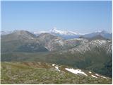
 | Snežna jama - Velika Raduha
At 2062 m, Velika Raduha is the highest peak of Raduha, a mountain range rising steeply to the east of Robanov Kot. From the summit, which has a ...
1 h 45 min |
 | end of road on Vogar - Pršivec (direct way)
Lookout Mountain is located above Lake Bohinj. The view is extensive on all sides. Triglav and the mountains around it can be seen, and on the ot...
1 h 30 min |
 | Planina Dol - Konj
Konj is a 1803 m high peak located between Velika planina and Presedlje. From the top, we have a beautiful view of the highest peaks of Kamnik Sa...
1 h 30 min |
 | Ravne - Rosenkogel/Hruški vrh (direct way)
Rosenkogel is a 1776 m high mountain located between Frauenkogel and the slightly less known Klek. From the top, where there is a small chapel de...
2 h |
 | Ski hotel Vogel - Šija
The peak is located above the Vogel ski slope in the Lower Bohinj Mountains. From the top there is a beautiful view of the neighbouring peaks in ...
1 h 30 min |
 | Tonkina koča na Vršiču - Sovna glava (on old road)
Sovna glava is a 1750 m high grassy peak located between Prisank and the Vršič Alpine Pass. From the top, you have a beautiful view of the peaks ...
1 h 10 min |
 | Sviščaki - Mali Snežnik
Mali Snežnik is a peak on the west ridge of Snežnika. Vrh, which is covered with dwarf pines, has a fine view of the neighbouring Veliki Snežnik ...
1 h 50 min |
 | Planina Zapleč - Krasji vrh (via Koluji)
Krasji vrh is located between Bovec and Kobarid on the Polovnik mountain ridge. At 1773m, Krasji vrh is also the highest peak of the ridge, offer...
2 h |
| Planina Zapleč - Krasji vrh (via snežna jama)
Krasji vrh is located between Bovec and Kobarid on the Polovnik mountain ridge. At 1773m, Krasji vrh is also the highest peak of the ridge, offer...
2 h |
 | Walischeben - Weißenstein (Packalpe) (Direct way)
Weissenstein is a grassy mountain interspersed with wire fences. From its inconspicuous summit there is a fine view of the neighbouring Ameringko...
1 h 45 min |
 | Walischeben - Ameringkogel (Packalpe) (Direct way)
Ameringkogel is a grassy peak on which a cross is placed and on which a registration box is placed. At 2187m, it is also the highest peak in the ...
1 h 55 min |
 | Walischeben - Hofalmkogel (Packalpe) (via Weissenstein)
Hofalmkogel is a less prominent peak in the ridge from Großenberg to Speikkogel. The summit is broad and mostly covered with grass. From the top ...
2 h 5 min |
 | Walischeben - Hofalmkogel (Packalpe) (past the cross)
Hofalmkogel is a less prominent peak in the ridge from Großenberg to Speikkogel. The summit is broad and mostly covered with grass. From the top ...
2 h 5 min |
| Salzstiegelhaus - Hofalmkogel (Packalpe)
Hofalmkogel is a less prominent peak in the ridge from Großenberg to Speikkogel. The summit is broad and mostly covered with grass. From the top ...
1 h 50 min |
 | Walischeben - Speikkogel (Packalpe)
Speikkogel is a vast and grassy peak in the Packalps. From the top you can enjoy a beautiful view of the Slovenian mountains and the mountains of...
2 h |
 | Salzstiegelhaus - Speikkogel (Packalpe)
Speikkogel is a vast and grassy peak in the Packalps. From the top you can enjoy a beautiful view of the Slovenian mountains and the mountains of...
1 h 15 min |
 | Zadnji travnik - Govca (Olševa)
Govca is the highest peak of the Olševa, a mountain range rising above Koprivna, Solčava and Remschenik (Remschenik / Remschenig is a valley on t...
1 h 45 min |
 | Jezerski vrh - Kärntner Storschitz / Pristovški Storžič
Kärntner Storschitz is an extremely scenic peak above Jezersko. It offers a beautiful view of the northern flanks of the Grintovci Mountains, thr...
1 h 50 min |
 | Dolinza Alm/Planina Dolnica - Starhand
Starhand is a scenic peak on the eastern part of Carnic Alps near the better known Ojstrnik. From the top you can enjoy a beautiful view of the J...
1 h 40 min |
 | Rosstratte - Dobratsch / Dobrač (by road)
Dobratsch is a massive mountain range located west of Belgrade. Its highest peak is the 2166m-high Kuhriegel, which has taken the name Dobratsch ...
1 h 20 min |
 | Rosstratte - Dobratsch / Dobrač (by road)
Dobratsch is a massive mountain range located west of Belgrade. Its highest peak is the 2166m-high Kuhriegel, which has taken the name Dobratsch ...
2 h |
 | Turracher Höhe - Kornock (northern way)
Kornock is a scenic peak located west of the Turracherhöhe mountain pass. The summit, which is also the highest point of the Turracherhöhe ski ar...
1 h 15 min |
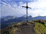
 | Turracher Höhe - Rinsennock (northern way)
Rinsennock is a 2334m high peak located in the heart of the Krkonoše Alps. From the summit on which the cross stands, there is a beautiful view f...
1 h 45 min |
| Turracher Höhe - Rinsennock (southern way)
Rinsennock is a 2334m high peak located in the heart of the Krkonoše Alps. From the summit on which the cross stands, there is a beautiful view f...
1 h 45 min |
 | Turracher Höhe - Schoberriegel
Schoberriegel is a 2208m high peak located between the Turracher Höhe Alpine Pass and the slightly higher Gruft. From the summit on which the cro...
1 h 20 min |
 | Turracher Höhe - Gruft
Gruft is a grass-covered peak located southeast of the Turracher Höhe Pass in the heart of the Krkonoše Alps. The 2232m-high peak offers a beauti...
1 h 45 min |
 | Sporthotel Maltatal - Arlhöhe
Arlhöhe is an inconspicuous peak located north of the Kölnbreinspeicher (above the Malta Valley). From the top of the peak, where the viewing pla...
1 h 45 min |
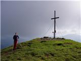
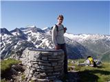
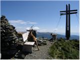
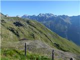
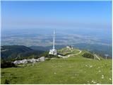 | Planina Jezerca - Krvavec
Krvavec is an 1853 m high peak located in the heart of the ski resort of the same name. The summit, which is criss-crossed with cable cars, offer...
1 h 10 min |
 | Planina Loka - Lanež (eastern way)
Lanež is a less distinct peak located in the eastern part of Raduha. The spacious peak offers a beautiful view of the nearby Mala Raduha, Olševa,...
1 h 25 min |
| Planina Loka - Lanež (via Durce)
Lanež is a less distinct peak located in the eastern part of Raduha. The spacious peak offers a beautiful view of the nearby Mala Raduha, Olševa,...
1 h 25 min |
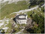 | Rifugio Selvapiana I.Lunelli - Belvedere (Creston Popera)
Belvedere is a 2125 m high peak located on the slopes of the Creston Popera ridge, a famous World War I battlefield. A stone semicircle is erecte...
1 h 40 min |
 | Heidi Alm - Schwarzkofel (ridge path)
Schwarzkofel is a 2168 m high peak located south of mountain pasture Heidialm. From the summit, on which stands a small cross, there is a fine vi...
2 h |
| Heidi Alm - Schwarzkofel (via Falkertscharte)
Schwarzkofel is a 2168 m high peak located south of mountain pasture Heidialm. From the summit, on which stands a small cross, there is a fine vi...
2 h 5 min |
 | Heidi Alm - Rodresnock (ridge path)
Rodresnock is a 2310 m high mountain rising south-west of Lake Falkertsee. From the top, where a large cairn and a cross in the middle of it stan...
1 h 30 min |
 | Heidi Alm - Rodresnock (via Falkertscharte)
Rodresnock is a 2310 m high mountain rising south-west of Lake Falkertsee. From the top, where a large cairn and a cross in the middle of it stan...
1 h 30 min |
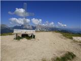
 | Heidi Alm - Falkert (via Falkertscharte)
Falkert is a 2308 m high peak located to the west of the village and lake Falkertsee. From the top, which has a few benches, a registration box w...
1 h 30 min |
 | Heidi Alm - Falkert (direct way)
Falkert is a 2308 m high peak located to the west of the village and lake Falkertsee. From the top, which has a few benches, a registration box w...
1 h 15 min |
 | Heidi Alm - Falkert (via Hundsfeldscharte)
Falkert is a 2308 m high peak located to the west of the village and lake Falkertsee. From the top, which has a few benches, a registration box w...
1 h 30 min |
 | Ciampac - Sas de Adam
Sas de Adam (aka Sass de Dama) is a 2430 m high peak located north of the Val de Sen Nicolo. From the top, you can enjoy a beautiful view of Piz ...
1 h 40 min |
 | Ski hotel Vogel - Visoki Orlov rob
Visoki Orlov rob is an 1800 m high peak located in the immediate vicinity of the upper station of the single-seater Šija. The summit, located sli...
1 h 15 min |
 | Weinebene - Hühnerstütze (Golica/Koralpe)
Hühnerstütze is a 1989 m high peak located in the Golice / Koralpe mountain range. From the unmarked, mostly grassy summit, we have a beautiful v...
2 h |
 | parking below Weinebene - Hühnerstütze (Golica/Koralpe) (panoramic path)
Hühnerstütze is a 1989 m high peak located in the Golice / Koralpe mountain range. From the unmarked, mostly grassy summit, we have a beautiful v...
2 h |
 | Weinebene Straße - Weberkogel
Weberkogel is a less prominent peak located north to north-west of the Weinebene Alpine Pass. On the 1805 m high summit is a medium-sized cairn a...
1 h 30 min |
| Gasthof Pfeifferstocker - Weberkogel
Weberkogel is a less prominent peak located north to north-west of the Weinebene Alpine Pass. On the 1805 m high summit is a medium-sized cairn a...
1 h 50 min |
 | Zettersfeld - Goiselemandl
Goiselemandl is a 2,433-metre-high peak in the Schober Group. The mountain is also quite well visited due to its proximity to the cable car. From...
1 h 30 min |
 | Rifugio Fedare - Monte Pore
Monte Pore or Spiz de Poure is a 2405 m high grassy peak located to the west of Averau and Nuvolau. The summit, on which the large cross stands, ...
1 h 30 min |
 | Eagles Nest - Mount Kosciuszko (Mt Kosciuszko Track)
Mount Kosciuszko is the highest mountain of the mainland Australia, it is the easiest one of the elite Seven Summits, and it is also among the Ul...
2 h |
 | Klippitztörl - Forstalpe (Saualpe) (via Geierkogel)
Forstalpe is an unstratified peak in the Svinja mountain pasture / Saualpe massif. The stamp for Forstalpe is located in an interesting natural w...
2 h 10 min |
| Klippitztörl - Forstalpe (Saualpe)
Forstalpe is an unstratified peak in the Svinja mountain pasture / Saualpe massif. The stamp for Forstalpe is located in an interesting natural w...
1 h 40 min |
 | Passo Campolongo - Stores
Stores is a 2,185-metre peak in the south-eastern part of the Pralongia plateau. The grassy summit on which the cross stands offers a very fine v...
2 h |
 | Wiesser Alm - Mirnock (Path 184)
Mirnock is a 2110 m high isolated and very scenic mountain massif in Carinthia. It is part of the Nockberge Group, which is part of Gurktal Alps ...
1 h 30 min |
 | parking below Weinebene - Steinmandl (Golica / Koralpe) (via Grünangerhütte)
Steinmandl is a scenic peak in the Golice / Koralpa mountain range, on which a large number of stone columns have been erected....
1 h 40 min |
 | Knödelhütte - Hirschegger Alm (southern peak)
...
1 h 35 min |
| Unterauerlinger Hütte - Hirschegger Alm (southern peak)
...
1 h 25 min |
 | Salzstiegelhaus - Peterer Riegel
...
1 h 45 min |
 | Hebalm (Gasthaus Zur Rehbockhütte) - Barofen
...
2 h |
 | Gasthof Pfeifferstocker - Barofen
...
2 h |
 | Gasthof Pfeifferstocker - Renneiskogel
...
1 h 45 min |
 | Nassfeld - Javornik / Auernig
...
1 h 30 min |
| Nassfeld - Javornik / Auernig (via Auernig Alm)
...
1 h 35 min |
 | Nassfeld - Garnitzenberg / Monte Carnizza (via Auernig Alm)
...
1 h 50 min |
| Nassfeld - Garnitzenberg / Monte Carnizza (Auernig Höhenweg)
...
2 h |
 | Kohlebnerstand - Windberg (northern path)
...
1 h 50 min |
| Kohlebnerstand - Windberg (southern path)
...
1 h 50 min |
 | Kohlebnerstand - Hoher Klapf
...
1 h 40 min |
 | Raxalm-Berggasthof (Rax) - Preiner Wand (Rax)
...
1 h 40 min |
 | Seebergsattel - Seeleiten
...
1 h 30 min |