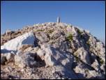
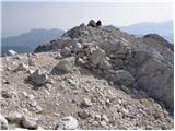
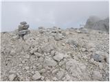
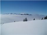
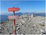
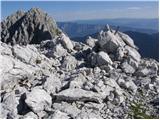
 | The Krma Valley - Mali Triglav (mimo Doma Planika pod Triglavom)
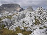
Mali Triglav is an inconspicuous peak on the main ridge of Triglav. Despite its considerable height, few hikers choose it as an independent desti...
5 h 25 min |
 | Ravenska Kočna - Grintovec (past the cableway and on Frischaufova pot)
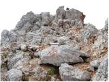
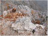
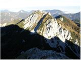
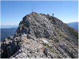
Grintovec is the highest peak in the Kamnik and Savinja Alps. It is located above the valley of Kamniška Bistrica, Suhi dol and above the valley ...
5 h 15 min |
 | Ravenska Kočna - Grintovec (past the cableway and on Kremžarjeva pot)
Grintovec is the highest peak in the Kamnik and Savinja Alps. It is located above the valley of Kamniška Bistrica, Suhi dol and above the valley ...
5 h 15 min |
| Ravenska Kočna - Grintovec (umik Žrela and on Frischaufova pot)
Grintovec is the highest peak in the Kamnik and Savinja Alps. It is located above the valley of Kamniška Bistrica, Suhi dol and above the valley ...
5 h 20 min |
| Ravenska Kočna - Grintovec (umik Žrela and on Kremžarjeva pot)
Grintovec is the highest peak in the Kamnik and Savinja Alps. It is located above the valley of Kamniška Bistrica, Suhi dol and above the valley ...
5 h 20 min |
 | Aljažev dom v Vratih - Triglavski dom na Kredarici (Tominšek route)
Triglavski dom na Kredarici is Slovenia's highest-serviced mountain hut. It is open all year round, but outside the season only on an emergency b...
4 h 55 min |
| Aljažev dom v Vratih - Triglavski dom na Kredarici (via Prag)
Triglavski dom na Kredarici is Slovenia's highest-serviced mountain hut. It is open all year round, but outside the season only on an emergency b...
5 h |
 | Ravenska Kočna - Jezerska Kočna (past the cableway and on Kremžarjeva pot)
Jezerska Kočna is located west of Grintovec. From the summit there is a very beautiful view towards Grintovec. The Karawanks and the Gorenjska pl...
5 h |
 | Suhadolnik - Jezerska Kočna (via Grdi graben and Dolci)
Jezerska Kočna is located west of Grintovec. From the summit there is a very beautiful view towards Grintovec. The Karawanks and the Gorenjska pl...
5 h 15 min |
 | Suhadolnik - Jezerska Kočna (via Grdi graben and Kokrska Kočna)
Jezerska Kočna is located west of Grintovec. From the summit there is a very beautiful view towards Grintovec. The Karawanks and the Gorenjska pl...
5 h 15 min |
| Ravenska Kočna - Jezerska Kočna (umik Žrela and on Kremžarjeva pot)
Jezerska Kočna is located west of Grintovec. From the summit there is a very beautiful view towards Grintovec. The Karawanks and the Gorenjska pl...
5 h 5 min |
| Ravenska Kočna - Jezerska Kočna (via Štularjeva planina and on path Kremžarjeva pot)
Jezerska Kočna is located west of Grintovec. From the summit there is a very beautiful view towards Grintovec. The Karawanks and the Gorenjska pl...
5 h |
 | The Kot Valley - Rjavina (climbing way)
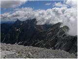
Rjavina is located between two Alpine valleys. The two valleys are Kot and Krma. From the summit, which has a registration book, there is a very ...
5 h |
 | Suhadolnik - Kokrska Kočna (via Grdi graben)
Kokrska Kočna is a scenic and vast mountain between Jezersko and Suhadolnik. From the top, which has a registration box, there is a very nice vie...
4 h 45 min |
 | V Koncu - Dolgi hrbet (via Kokrsko sedlo)
Dolgi Hrbet is located between Grintovec and Skuta. The precipitous peak offers a beautiful view of the heart of the Kamnik and Savinja Alps. Dol...
5 h |
 | Ravenska Kočna - Dolgi hrbet (past the cableway and on Frischaufova pot)
Dolgi Hrbet is located between Grintovec and Skuta. The precipitous peak offers a beautiful view of the heart of the Kamnik and Savinja Alps. Dol...
5 h |
| Ravenska Kočna - Dolgi hrbet (umik Žrela and on Frischaufova pot)
Dolgi Hrbet is located between Grintovec and Skuta. The precipitous peak offers a beautiful view of the heart of the Kamnik and Savinja Alps. Dol...
5 h 5 min |
| Ravenska Kočna - Dolgi hrbet (via Štularjeva planina and on path Frischaufova pot)
Dolgi Hrbet is located between Grintovec and Skuta. The precipitous peak offers a beautiful view of the heart of the Kamnik and Savinja Alps. Dol...
5 h |
 | Aljažev dom v Vratih - Begunjski vrh (via Prag)
Begunjski vrh is a 2461 m high mountain located in the heart of the highest mountains in the Julian Alps. From the top, which has a registration ...
5 h |
| Aljažev dom v Vratih - Begunjski vrh (Tominšek route)
Begunjski vrh is a 2461 m high mountain located in the heart of the highest mountains in the Julian Alps. From the top, which has a registration ...
4 h 55 min |
 | Ravenska Kočna - Kranjska Rinka (Slovenska pot)
Kranjska Rinka is the highest of all the Rinkas. From the summit, which has a registration book, the best view is towards Skuta. The other Rinkas...
4 h 35 min |
| Belska Kočna - Kranjska Rinka
Kranjska Rinka is the highest of all the Rinkas. From the summit, which has a registration book, the best view is towards Skuta. The other Rinkas...
5 h 5 min |
| Ravenska Kočna - Kranjska Rinka (via Žrelo)
Kranjska Rinka is the highest of all the Rinkas. From the summit, which has a registration book, the best view is towards Skuta. The other Rinkas...
4 h 35 min |
| Ravenska Kočna - Kranjska Rinka (hunting path)
Kranjska Rinka is the highest of all the Rinkas. From the summit, which has a registration book, the best view is towards Skuta. The other Rinkas...
4 h 50 min |
 | Vranček - Veliki vrh (Košuta) (climbing way)
Veliki vrh, with a height of 2088 m, is the westernmost two-thousander in the longest Slovenian ridge Košuta. From the summit, where there is a ...
3 h 10 min |
| Sele-Zvrhnji Kot (Male) / Zell-Oberwinkel (Male) - Veliki vrh (Košuta)
Veliki vrh, with a height of 2088 m, is the westernmost two-thousander in the longest Slovenian ridge Košuta. From the summit, where there is a ...
4 h 35 min |
 | Zalog - Storžič (via Psica)
Storžič is a 2132 m high mountain located in the western part of the Kamnik-Savinja Alps. From the summit, where there is a cross, there is a bea...
4 h 30 min |
| Gozd - Storžič (via Psica)
Storžič is a 2132 m high mountain located in the western part of the Kamnik-Savinja Alps. From the summit, where there is a cross, there is a bea...
4 h 45 min |
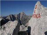 | NC Planica - Visoka Ponca
Visoka Ponca is located on the border with Italy and has beautiful views of the mountains above the Tamar Valley and the Italian Julian Alps. Fro...
4 h 45 min |
| Belopeška jezera - Visoka Ponca (via normale)
Visoka Ponca is located on the border with Italy and has beautiful views of the mountains above the Tamar Valley and the Italian Julian Alps. Fro...
4 h |
 | Belopeška jezera - Visoka Ponca (ferrata)
Visoka Ponca is located on the border with Italy and has beautiful views of the mountains above the Tamar Valley and the Italian Julian Alps. Fro...
4 h |
 | Rogovilec - Velika Raduha (via Grohat on the climbing path)
At 2062 m, Velika Raduha is the highest peak of Raduha, a mountain range rising steeply to the east of Robanov Kot. From the summit, which has a ...
4 h 30 min |
 | Drežnica - Krn (Silvo Koren route)
At 2244 m, Krn is the highest peak of the Krn Mountains, a mountain range that rises steeply above the central part of the Soča River. From the s...
5 h |
 | NC Planica - Mala Mojstrovka (via Grlo)
Mala Mojstrovka is one of the most visited peaks in the Julian Alps due to the relatively high altitude of the starting point. From the summit, w...
4 h 35 min |
 | Pišnica - Križ
Križ is a 2140 m high mountain located north-east of the Kriški Podi. From the top, where there is a registration box with a stamp, you have a be...
5 h 25 min |
 | V Koncu - Kalški greben
Kalški greben is 2224 m high and is the highest peak of the eponymous ridge. The summit, which has a registration box and a stamp, offers a beaut...
4 h |
| Suhadolnik - Kalški greben
Kalški greben is 2224 m high and is the highest peak of the eponymous ridge. The summit, which has a registration box and a stamp, offers a beaut...
4 h 15 min |
 | Aljažev dom v Vratih - Visoka Vrbanova špica (via Prag)
Visoka Vrbanova špica, is located at the extreme south-western part of the ridge rising above the Kot and Vrata valleys, and higher up between th...
4 h 50 min |
 | The Kot Valley - Visoka Vrbanova špica (Lojze Rekar route)
Visoka Vrbanova špica, is located at the extreme south-western part of the ridge rising above the Kot and Vrata valleys, and higher up between th...
5 h 10 min |
| Aljažev dom v Vratih - Visoka Vrbanova špica (Tominšek route)
Visoka Vrbanova špica, is located at the extreme south-western part of the ridge rising above the Kot and Vrata valleys, and higher up between th...
4 h 45 min |
 | Sele pri Cerkvi / Zell - Pfarre - Koschutnikturm (Košutnikov turn) (ÖTK Steig Neu)
Košutna Turn is the highest peak in Slovenia's longest ridge, the Košuta. From the top, you have a beautiful view of the entire ridge. Austria an...
4 h |
| Ridovc / Ridovcsäge - Koschutnikturm (Košutnikov turn) (along Mrzlem potok and via ÖTK Steig Neu)
Košutna Turn is the highest peak in Slovenia's longest ridge, the Košuta. From the top, you have a beautiful view of the entire ridge. Austria an...
4 h 10 min |
 | Ravenska Kočna - Ledinski vrh (Slovenian way)
The mountain is located above Jezersko, on the border with Austria. From the top there is a beautiful view towards the neighbouring Baba to the n...
3 h 15 min |
| Ravenska Kočna - Ledinski vrh (via Žrelo)
The mountain is located above Jezersko, on the border with Austria. From the top there is a beautiful view towards the neighbouring Baba to the n...
3 h 15 min |
 | Ravenska Kočna - Koroška Rinka (Slovenska pot)
Koroška Rinka (also Križ) is a 2433 m high mountain rising steeply above Lediny and Okrešlje. From the top, which has a registration box and a st...
4 h 15 min |
| Belska Kočna - Koroška Rinka
Koroška Rinka (also Križ) is a 2433 m high mountain rising steeply above Lediny and Okrešlje. From the top, which has a registration box and a st...
4 h 45 min |
| Ravenska Kočna - Koroška Rinka (via Žrelo)
Koroška Rinka (also Križ) is a 2433 m high mountain rising steeply above Lediny and Okrešlje. From the top, which has a registration box and a st...
4 h 15 min |
| Ravenska Kočna - Koroška Rinka (hunting path)
Koroška Rinka (also Križ) is a 2433 m high mountain rising steeply above Lediny and Okrešlje. From the top, which has a registration box and a st...
4 h 30 min |
 | Ravenska Kočna - Štajerska Rinka (Slovenska pot)
Štajerska Rinka is a 2374 m high mountain rising steeply above Okrešl, more precisely to the east of the more visited Koroška Rinka. From the top...
4 h 30 min |
| Ravenska Kočna - Štajerska Rinka (via Žrelo)
Štajerska Rinka is a 2374 m high mountain rising steeply above Okrešl, more precisely to the east of the more visited Koroška Rinka. From the top...
4 h 30 min |
| Ravenska Kočna - Štajerska Rinka (hunting path)
Štajerska Rinka is a 2374 m high mountain rising steeply above Okrešl, more precisely to the east of the more visited Koroška Rinka. From the top...
4 h 45 min |
 | Jermanca - Turska gora (via Kamniško sedlo)
The mountain is located above the Logarska Valley and the Kamniška Bistrica Valley. From the top there is a beautiful view towards the neighbouri...
4 h 45 min |
 | Podkraj / Unterort - Petzen (Kordeschkopf) (Peca (Kordeževa glava)) (Walter Mory Klettersteig)
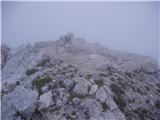
Kordeževa glava, better known as Peca is the highest summit in the mountain chain Peca. It is located on the border with Austria above Mežiška do...
5 h 20 min |
 | Podpeca (Mitnek) - Petzen (Kordeschkopf) (Peca (Kordeževa glava)) (climbing way)
Kordeževa glava, better known as Peca is the highest summit in the mountain chain Peca. It is located on the border with Austria above Mežiška do...
4 h 15 min |
| Koča na Pikovem - Petzen (Kordeschkopf) (Peca (Kordeževa glava)) (over saddle Vrh šteng and on climbing way)
Kordeževa glava, better known as Peca is the highest summit in the mountain chain Peca. It is located on the border with Austria above Mežiška do...
3 h 45 min |
| Podpeca (Helenski potok) - Petzen (Kordeschkopf) (Peca (Kordeževa glava)) (over Mirjance and on climbing way)
Kordeževa glava, better known as Peca is the highest summit in the mountain chain Peca. It is located on the border with Austria above Mežiška do...
4 h 40 min |
| Topla (Burjak) - Petzen (Kordeschkopf) (Peca (Kordeževa glava)) (over Mala Peca and on climbing way)
Kordeževa glava, better known as Peca is the highest summit in the mountain chain Peca. It is located on the border with Austria above Mežiška do...
4 h |
 | Ravenska Kočna - Velika (Koroška) Baba (on Slovenska and climbing way)
Velika is a 2127 m high mountain on the border ridge above the Ravenská Kočna valley on the Slovenian side and above the Bela valley (Belska Kočn...
3 h 45 min |
| Ravenska Kočna - Velika (Koroška) Baba (on Slovenska pot and over Jezersko sedlo)
Velika is a 2127 m high mountain on the border ridge above the Ravenská Kočna valley on the Slovenian side and above the Bela valley (Belska Kočn...
4 h 15 min |
| Ravenska Kočna - Velika (Koroška) Baba (through Žrelo and on climbing way)
Velika is a 2127 m high mountain on the border ridge above the Ravenská Kočna valley on the Slovenian side and above the Bela valley (Belska Kočn...
3 h 45 min |
| Ravenska Kočna - Velika (Koroška) Baba (on hunting and climbing path)
Velika is a 2127 m high mountain on the border ridge above the Ravenská Kočna valley on the Slovenian side and above the Bela valley (Belska Kočn...
4 h |
| Ravenska Kočna - Velika (Koroška) Baba (through Žrelo and over Jezersko sedlo)
Velika is a 2127 m high mountain on the border ridge above the Ravenská Kočna valley on the Slovenian side and above the Bela valley (Belska Kočn...
4 h 15 min |
 | Zadnja Trenta (Flori) - Bavški Grintavec (via Kanski preval)
Bavški Grintavec is a mighty mountain rising steeply above the valleys of Bavšica, Zadnja Trenta and Soča. All the approaches to the summit are l...
4 h 45 min |
| Zadnja Trenta (Flori) - Bavški Grintavec (direct way)
Bavški Grintavec is a mighty mountain rising steeply above the valleys of Bavšica, Zadnja Trenta and Soča. All the approaches to the summit are l...
4 h 30 min |
 | The Kot Valley - Spodnja Vrbanova špica (via Lojze Rekar)
Spodnja Vrbanova špica is a 2299 metre high mountain above the Kot valley and above the Za Cmir valley. From the top there is a very nice view of...
4 h |
 | Tolminske Ravne - Vrh nad Škrbino (on steep pathi and over Škrbina)
Vrh nad Škrbino is the easternmost two-thousandth peak in the ridge of the Lower Bohinj Mountains. From the top there is a very nice view of the ...
4 h |
 | Reißkofelbad - Reißkofel (via bivouac)
Reißkofel is a 2371 metre high mountain in the Zilj Alps. The summit on which the cross stands also has a registration box. The view from the top...
4 h 30 min |
 | Belopeška jezera - Srednja Ponca / Ponza di Mezze
Srednja Ponca is a 2228m high peak rising steeply above Tamar, Planica and the Mangart valley. From the summit on which the stamp is located, the...
3 h 45 min |
 | NC Planica - Zadnja Ponca / Ponza di Detro
Zadnja Ponca is a 2242m high peak located on the narrow and precipitous Ponc ridge. The summit, which is not accessible to everyone, offers a bea...
4 h 50 min |
| Belopeška jezera - Zadnja Ponca / Ponza di Detro
Zadnja Ponca is a 2242m high peak located on the narrow and precipitous Ponc ridge. The summit, which is not accessible to everyone, offers a bea...
4 h 30 min |
 | Podkraj / Unterort - Končnikov vrh (Peca) (Walter Mory Klettersteig)
Končnikov vrh is a 2109 m high mountain located in the central part of Pec. The grassy peak offers a beautiful view along the Pec ridge and the m...
4 h 5 min |
 | Velacher Kotschna/Belska Kočna - Vellacher Turm/Storžek
Vellacher Turm or Belski turn is a 2110 m high mountain located on the Austrian side of the Jezersko saddle. From the top, which is not shown on ...
3 h 15 min |
| Ravenska Kočna - Vellacher Turm/Storžek (Slovenska pot)
Vellacher Turm or Belski turn is a 2110 m high mountain located on the Austrian side of the Jezersko saddle. From the top, which is not shown on ...
4 h |
| Ravenska Kočna - Vellacher Turm/Storžek (via Žrelo)
Vellacher Turm or Belski turn is a 2110 m high mountain located on the Austrian side of the Jezersko saddle. From the top, which is not shown on ...
4 h |
| Ravenska Kočna - Vellacher Turm/Storžek (hunting path)
Vellacher Turm or Belski turn is a 2110 m high mountain located on the Austrian side of the Jezersko saddle. From the top, which is not shown on ...
4 h 15 min |
 | Aljažev dom v Vratih - Kredarica (via Prag)
Kredarica is a 2541-metre-high peak located between Triglav and Ržja. From the top, we have a beautiful view towards Triglav and the surrounding ...
5 h 5 min |
| Aljažev dom v Vratih - Kredarica (Tominšek route)
Kredarica is a 2541-metre-high peak located between Triglav and Ržja. From the top, we have a beautiful view towards Triglav and the surrounding ...
5 h |
 | Val Aupa - Creta Grauzaria (via normale)
Creta Grauzaria (in Friul: La Crete) is a 2065 meter high mountain in Carnic Alps in Italy. The mountain was climbed for the first time on 18th J...
4 h 20 min |
 | Bagni di Lusnizza - Monte Gosadon
Monte Gosadon is a slightly less visited peak in the Naborjeta group. There are also a number of World War I remains in the vicinity of the peak....
3 h 50 min |
 | Pišnica - Lipnica (via Koča v Krnici)
...
4 h 55 min |