 | Prosen - Mlaka
Mlaka or Prosenov grič is a forested peak between Pasja ravan and Tošč. Due to the forest, the peak has no view....
20 min |
 | Veliki Ločnik - Sveti Ahac
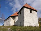
The Church of St. Ahac is located on the summit named Gora above the villages of Mali and Veliki Ločnik near Turjak. From the top, which has a lo...
30 min |
 | Lanišče - Janče
Janče is a 792-meter-high peak situated between the Sava River and the Besnica stream valley. From the summit, where a mountain hut stands and th...
30 min |
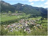
 | Sveta Ana - Križna gora
Križna gora is a partly panoramic peak located above the villages of Sveta Ana and Podlož. From the summit, where the Church of the Holy Cross st...
20 min |
 | Velika vrata - Velika Plešivica
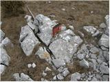
Velika Plešivica is a 908-meter peak located between Slavnik and the lesser-known Mala Plešivica. The summit, which features a destroyed logbook ...
25 min |
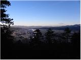
 | Zgornja Javoršica - Murovica
Murovica is a popular excursion point, accessible from the Posavje side, Domžale, or the Moravška Valley. On the summit there is a bench and a lo...
25 min |
 | Begunje - Goli vrh (Cemarovnik)
Goli vrh, also known as Begunjski Cemarovnik, is an 816 m high mountain located on the southeastern part of Menišija. From the summit, where a la...
30 min |
 | Topol - Goljek
Goljek is an 809 m high peak located east of Polhograjska Grmada. From the summit, where remains of a former guard tower on the Italian-German bo...
20 min |
 | Topol - Goljek (on west ridge)
Goljek is an 809 m high peak located east of Polhograjska Grmada. From the summit, where remains of a former guard tower on the Italian-German bo...
30 min |
 | Trebež (Jesenice) - Kozjek (on east ridge)
Kozjek is a 766 m high, easily accessible ridge-like secondary peak of Jelenkamen, belonging to the southern Karawanks foothills; it is located a...
30 min |
 | Hunting sports association Vinska Gora - Temnjak
Temnjak (on some maps also written as Vinska gora, the neighboring hill) is a 798 m high peak located north of the village of Prelska pri Vinski ...
25 min |
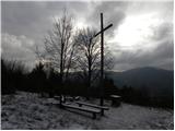
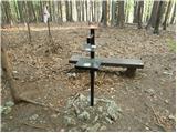
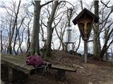
 | Mojstrana - Grančišče (south path)
Grančišče (also Grančiše) is a small precipitous hill rising west to southwest of Mojstrana. From the summit, where there is a bench and table, a...
25 min |
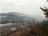
 | Pivka - Primož
Primož is a 718-meter-high peak located south to southeast of Pivka. Due to its ideal location overlooking the entire Pivka Basin, the Italians b...
25 min |
 | Žusem Castle - Žusem
Žusem is a 669-meter-high hill with a rich history and great potential for the future. It forms the northern edge of Kozjansko, and its name deri...
30 min |
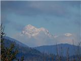
 | Laško - Gradišče (Pustinjak)
Gradišče or Pustinjak (also Gradišče nad Bašljem) is an 871-meter-high peak located above the Belica stream, which lies below the 2,132-meter-hig...
20 min |
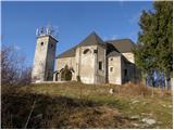
 | border crossing Remšnik - Sveti Pankracij (Radelca)
The Church of St. Pankracij on Radelca lies on the border ridge between Slovenia and Austria; since 1966, following an interstate agreement, it h...
25 min |
 | Žiri - Goropeški grič (Pikrej)
Goropeški grič, also known as Pikrej, is located south of Žiri. From the meadows near the logbook box, a nice view opens up onto the surrounding ...
30 min |
 | Planina pri Sevnici - Sveti Križ (above Planina pri Sevnici) (via Pravljični gozd)
The Church of the Holy Cross is located above Planina pri Sevnici, near the settlement of Šentvid pri Planini. From the summit opens a fine view ...
28 min |
| Planina pri Sevnici - Sveti Križ (above Planina pri Sevnici)
The Church of the Holy Cross is located above Planina pri Sevnici, near the settlement of Šentvid pri Planini. From the summit opens a fine view ...
23 min |
 | Waldgebiet - Großer Hirschenstein
Großer Hirschenstein is an 862-meter-high peak located west of the slightly higher Geschriebenstein / Írott-kő, the highest point in the Austrian...
30 min |
 | Road on Bjelsko - Stožac
Stožac is a distinct peak situated south of the more famous Klek, above Ogulin. There is no marked trail to the summit itself. Just below the top...
30 min |