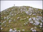
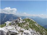
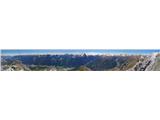
 | Sella Nevea - Prestreljenik (on ski track)
Prestreljenik is a 2499 m high mountain located in the heart of the Kanin Mountains. From the top, where the Aljaž Tower-shaped registration box ...
3 h 30 min |
 | Podljubelj (Lajb) - Begunjščica
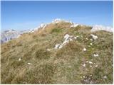
Begunjščica is a mountain range in the Karavanke east of Stol. The highest peak is Veliki vrh, which at over 2000 m offers a beautiful view of ce...
3 h 30 min |
 | Ljubelj - Begunjščica (via Zelenica)
Begunjščica is a mountain range in the Karavanke east of Stol. The highest peak is Veliki vrh, which at over 2000 m offers a beautiful view of ce...
3 h 50 min |
 | Tinčkova koča - Begunjščica (via Poljška planina)
Begunjščica is a mountain range in the Karavanke east of Stol. The highest peak is Veliki vrh, which at over 2000 m offers a beautiful view of ce...
3 h 50 min |
 | Ljubelj - Hochstuhl/Stol (upper way)
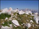
Stol is, at 2236 m, the highest peak of the Karavanke. From the summit, which has a registration box and a stamp, we have a beautiful view of the...
4 h 50 min |
| Johannsenruhe - Hochstuhl/Stol (via Klagenfurter Hütte)
Stol is, at 2236 m, the highest peak of the Karavanke. From the summit, which has a registration box and a stamp, we have a beautiful view of the...
3 h 45 min |
| Ljubelj - Hochstuhl/Stol (via Vatelca or Skleda)
Stol is, at 2236 m, the highest peak of the Karavanke. From the summit, which has a registration box and a stamp, we have a beautiful view of the...
5 h |
 | Uskovnica (Lom) - Viševnik (via Srenjski preval)
Viševnik is a 2050 m high mountain rising northwest of Rudno polje on Pokljuka. From the summit, where the stamp is located, a beautiful view ope...
3 h 10 min |
 | Ljubelj - Vertatscha/Vrtača
Vrtača is a 2181 m high peak located east of Stol. From the summit, where a large peg stands, a beautiful view opens up of parts of the Julian Al...
3 h 30 min |
| Tinčkova koča - Vertatscha/Vrtača (via Smuška planina in saddle Šija)
Vrtača is a 2181 m high peak located east of Stol. From the summit, where a large peg stands, a beautiful view opens up of parts of the Julian Al...
3 h 30 min |
| Trate / Johannsenruhe - Vertatscha/Vrtača
Vrtača is a 2181 m high peak located east of Stol. From the summit, where a large peg stands, a beautiful view opens up of parts of the Julian Al...
4 h |
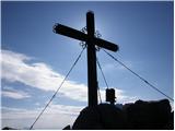
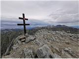
 | Gozd - Storžič (through southwest groove)
Storžič is a 2132 m high mountain located in the western part of the Kamnik-Savinja Alps. From the summit, where there is a cross, there is a bea...
4 h 50 min |
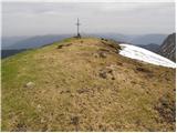
 | Markova raven - Kalška gora (on marked path)
Kalška gora is located between Kalški greben and Kokrsko sedlo. From the top, which is covered with grass, there is a beautiful view towards the ...
5 h 30 min |
| Kokra (Roblek) - Kalška gora (via Kalce)
Kalška gora is located between Kalški greben and Kokrsko sedlo. From the top, which is covered with grass, there is a beautiful view towards the ...
4 h 30 min |
 | Planina Kuhinja - Krn (via jezero v Lužnici)
At 2244 m, Krn is the highest peak of the Krn Mountains, a mountain range that rises steeply above the central part of the Soča River. From the s...
4 h 45 min |
 | Planina Kuk - Tolminski Kuk
Tolminski Kuk is the highest peak of the Lower Bohinj Mountains. The summit, which has a registration box, offers a very nice view. From the top ...
4 h 30 min |
 | Tolminske Ravne - Tolminski Kuk (via Dolina pod Ploščo)
Tolminski Kuk is the highest peak of the Lower Bohinj Mountains. The summit, which has a registration box, offers a very nice view. From the top ...
4 h 35 min |
 | Planina Blato - Zasavska koča na Prehodavcih (via Štapce)
Zasavska koča na Prehodavcih is located on a scenic peak above the Triglav Lakes Valley. The hut, which is open in the summer season, offers a be...
5 h 15 min |
 | Ljubelj - Prešernova koča na Stolu (upper way)
Prešernova koča na Stolu, is located just a few metres below the summit of the 2198 m high Mali Stol. From the hut or the nearby Mali Stol, we ha...
4 h 45 min |
| Ljubelj - Prešernova koča na Stolu (via Vatelca or Skleda)
Prešernova koča na Stolu, is located just a few metres below the summit of the 2198 m high Mali Stol. From the hut or the nearby Mali Stol, we ha...
4 h 55 min |
 | Trate / Johannsenruhe - Prešernova koča na Stolu (via Celovška koča)
Prešernova koča na Stolu, is located just a few metres below the summit of the 2198 m high Mali Stol. From the hut or the nearby Mali Stol, we ha...
3 h 40 min |
 | Kokra (Roblek) - Kalški greben
Kalški greben is 2224 m high and is the highest peak of the eponymous ridge. The summit, which has a registration box and a stamp, offers a beaut...
3 h 55 min |
 | Dom v Lepeni - Bogatin (via Bogatinsko sedlo)
Bogatin aka Little Bogatin is the last or first peak in the chain of the Lower Bohinj Mountains. From the top of the summit, where the registrati...
4 h 30 min |
 | Dom v Lepeni - Mahavšček (via Bogatinsko sedlo)
Mahavšček or Big Bogatin is a 2008 m high mountain located on the north-western outskirts of the Lower Bohinj Mountains. From the top, where ther...
5 h |
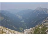
 | Ravenska Kočna - Ledinski vrh (hunter's way)
The mountain is located above Jezersko, on the border with Austria. From the top there is a beautiful view towards the neighbouring Baba to the n...
3 h 30 min |
| Koča pod slapom Rinka - Ledinski vrh
The mountain is located above Jezersko, on the border with Austria. From the top there is a beautiful view towards the neighbouring Baba to the n...
3 h 30 min |
 | Velacher Kotschna/Belska Kočna - Ledinski vrh
The mountain is located above Jezersko, on the border with Austria. From the top there is a beautiful view towards the neighbouring Baba to the n...
3 h 45 min |
 | Matizovec - Veliko Kladivo
Veliko Kladivo is a 2094 m high peak in the Košuta Ridge, the longest Slovenian ridge. From the summit, which has a registration box and a stamp,...
3 h 20 min |
| Dolina - Veliko Kladivo
Veliko Kladivo is a 2094 m high peak in the Košuta Ridge, the longest Slovenian ridge. From the summit, which has a registration box and a stamp,...
3 h 30 min |
| Dolina - Veliko Kladivo (past the chapel)
Veliko Kladivo is a 2094 m high peak in the Košuta Ridge, the longest Slovenian ridge. From the summit, which has a registration box and a stamp,...
3 h 30 min |
 | Planina Kuhinja - Batognica
Batognica is a 2164 m high mountain, which was affected by the Mine War during World War I. Remnants of the mine war between the Italians and the...
3 h 20 min |
| Dom v Lepeni - Batognica (via Krnska škrbina)
Batognica is a 2164 m high mountain, which was affected by the Mine War during World War I. Remnants of the mine war between the Italians and the...
4 h 50 min |
 | Zavrzeln - Rombon
Rombon is a lookout mountain above Bovec. It is known for being the mountain with the most man-made tunnels in Slovenia. During the First World W...
5 h |
 | Bele Vode - Jerebica
Jerebica is a mountain located on the border between Slovenia and Itali, between Moznica and the Jezersko Valley. The summit, which has a registr...
3 h 30 min |
 | Planina Blato - Mala Zelnarica (Za Kopico)
Mala Zelnarica is a 2310 m high peak located between the Triglav Lakes Valley and the Za Kopica Valley. The summit, which has a registration box ...
4 h 15 min |
 | Planina Blato - Mala Zelnarica (via Štapce)
Mala Zelnarica is a 2310 m high peak located between the Triglav Lakes Valley and the Za Kopica Valley. The summit, which has a registration box ...
5 h 10 min |
 | Tinčkova koča - Bielschitza/Svačica (via Smokuška planina)
Bielschitza is a less prominent peak in the main ridge of the Karavanke. It is located between Vertatscha and Stol and is slightly offset to the ...
3 h 30 min |
 | Ljubelj - Bielschitza/Svačica (upper path)
Bielschitza is a less prominent peak in the main ridge of the Karavanke. It is located between Vertatscha and Stol and is slightly offset to the ...
4 h 20 min |
| Ljubelj - Bielschitza/Svačica (via Vatelca or Skleda)
Bielschitza is a less prominent peak in the main ridge of the Karavanke. It is located between Vertatscha and Stol and is slightly offset to the ...
4 h |
 | Žabnice/Camporosso in Valcanale - Kamniti lovec / Cima del Cacciatore
Kamniti lovec is a popular excursion point above Trbiz. It is well visited due to its short access, which is shortened by a cable car to Višarje....
3 h 15 min |
 | Koča pod slapom Rinka - Velika (Koroška) Baba
Velika is a 2127 m high mountain on the border ridge above the Ravenská Kočna valley on the Slovenian side and above the Bela valley (Belska Kočn...
4 h 30 min |
| Ravenska Kočna - Velika (Koroška) Baba (on hunting path and over Jezersko sedlo)
Velika is a 2127 m high mountain on the border ridge above the Ravenská Kočna valley on the Slovenian side and above the Bela valley (Belska Kočn...
4 h 30 min |
 | Tolminske Ravne - Vrh nad Škrbino (on mule track and direct way)
Vrh nad Škrbino is the easternmost two-thousandth peak in the ridge of the Lower Bohinj Mountains. From the top there is a very nice view of the ...
4 h |
 | Weissensee - Eckwand (via Almspitz)
Eckwand is a 2221-metre peak in the Latschur Group. The grassy summit on which the cross stands offers a beautiful view of Gailtaler Alps, Carnic...
4 h 45 min |
 | Untere Valentinalm - Rauchkofel
To the north of Monte Coglians, the highest peak of Carnic Alps, is the 2460 m high Rauchkofel. From the top, where a cross and a signing box sta...
3 h 15 min |
| Untere Wolayeralm - Rauchkofel
To the north of Monte Coglians, the highest peak of Carnic Alps, is the 2460 m high Rauchkofel. From the top, where a cross and a signing box sta...
3 h 45 min |
 | Planina Kuk - Zeleni vrh
Zeleni vrh is a 2052 m high mountain located east of the highest peak of the Lower Bohinj Mountains. The grassy peak, which descends precipitousl...
4 h 5 min |
 | Tolminske Ravne - Zeleni vrh (via Dolina pod Ploščo)
Zeleni vrh is a 2052 m high mountain located east of the highest peak of the Lower Bohinj Mountains. The grassy peak, which descends precipitousl...
4 h 10 min |
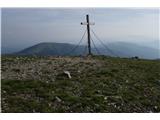
 | Klammbrückl - Weittalspitze
Weittalspitze is a 2,539-metre-high peak in the Lienz Dolomites. The summit is located south of the mountain pasture Kerschbaumeralm. From the su...
3 h 30 min |
 | Pala Barzana - Monte Raut (CAI 967)
Raut is a 2025 m high limestone lookout over the Friuli plain and the second highest peak of the ridge between Lakes Barcis and Selva. Its striki...
3 h 45 min |
 | Kesselfall - Höhenburg
Höhenburg is a 2108 metre high mountain in the Glockner mountain group in the High Tauern. It is located next to the Moserboden reservoir. From t...
3 h 50 min |
 | Weißenbach - Spitzegel / Negal (25d)
Spitzegel or. Negal (in Slovene) is a 2119 m high mountain in Gailtal Alps in Austria.The narrow ridge is a logical continuation of Dobrač / Dobr...
3 h 40 min |
 | Collina - Cima Ombladet (path 141)
Cima Ombladet is a 2255-metre-high mountain in Carnic Alps, east of Forni Avoltri. From the top of the hill, where there is a small cross, there ...
3 h 20 min |
 | Neustift im Stubaital - Hoher Burgstall (south path via Starkenburger Hütte)
Hoher Burgstall is one of the 7 classic Stubai Alps peaks, recognised by locals as outstanding in historical, touristic and aesthetic terms, whic...
4 h 15 min |
 | Tri studničky - Kriváň
Mount Kriváň is the first dominant peak of the High Tauern, seen from the west, and belongs to the Tatra National Park. It rises above the Liptov...
4 h |
 | Parkplatz Tappenkarweg - Weißgrubenkopf (Parkplatz Tappenkarweg - Weißgrubenkopf)
...
3 h 30 min |
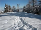
| Koča pod slapom Rinka - Skuta Glacier
...
4 h 10 min |
 | Sankt Ilgen (Der Bodenbauer) - Hochschwab (past Häuslalmhütte)
...
5 h 30 min |
 | parking lot Hoyer (Neuhofgraben) - Speikkogel (Gleinalpe)
...
3 h 30 min |
 | parking lot Hoyer (Neuhofgraben) - Lenzmoarkogel (Gleinalpe)
...
3 h 45 min |