|
| MarkoK3. 01. 2010 20:42:28 |
In wonderful weather Great Draški allowed itself to be conquered. Start of the hike from Rudno polje past Planina Konjščica then to Studorski preval, ascent to the Great via ridge path, descent directly from the top down towards Little Draški, but with my friend after descent from the top we continued (as did others we met) right towards the ascent path to the pass. The path is trodden, but especially on descent crampons are recommended, mainly in the upper part, where it is partly quite icy. Our hiking time just over five hours. Views evident from attached pics. Recommend.
|
|
|
|
| mjakopic13. 01. 2010 11:17:43 |
what's the avalanche release risk here, given the slope isn't that steep?
|
|
|
|
| lukapet15. 01. 2010 14:31:25 |
I'm also interested in the conditions. Planning to go this Saturday, on foot. If anyone been these days, report what conditions are.
|
|
|
|
| alpin15. 01. 2010 17:21:04 |
I'm wondering if Rudno polje is out of the clouds, so you can see out.? I'd go tomorrow to Viševnik or VDV with a paraglider and land there if possible. L.P
|
|
|
|
| Tadej15. 01. 2010 17:23:01 |
Today the base of low clouds was between 1500 and 1600 m, yesterday 200 m lower.
|
|
|
|
| alpin15. 01. 2010 17:24:50 |
|
|
|
|
| jeroldini16. 01. 2010 10:23:07 |
lp.
Tomorrow morning we plan to go to Great Draški Peak from Pokljuka. I'd like to refresh memory where exactly from Pokljuka and best place to leave car and approx walking time in winter conditions.
If too long we'll go only to Viševnik.
LP.
|
|
|
|
| kolesar16. 01. 2010 12:06:31 |
Car at barracks then straight road past shooting range to pl. Konjščica from there clear right? My time winter cond: to pl. Konjščica 1h then to top total 3h15m, return under 3h. Tempts me too tomorrow up. Good hiking.
|
|
|
|
| alpin16. 01. 2010 19:57:42 |
Today we went to Great Draški Peak from Rudno polje. Path trodden but crusty especially from Jezerc on. Towards top partly frozen, recommend crampons. From top 3 paragliders incl 2 women landed at Jezerci 1700m. Lower fog. L.P.
Video:
 8 8
|
|
|
|
| lukapet16. 01. 2010 20:02:54 |
Today I made an ascent to Veliki Draški vrh. In my opinion, the shorter version to the top is if you go towards the ski lifts and then at the lower station go left along the road, as if going to Triglav - there are signs too. This path goes above the planina and joins the one that comes from planina Konjščica just before Jezerci, then towards Studerski preval and to the top. Today I took 3 hours from the parking lot to the top, on foot.
Otherwise, conditions were excellent, the fog started clearing at Na Jezercih, a bit higher up it completely dissipated. No wind, quite warm. Lots of people, not huge numbers, walked and skied lengthwise and crosswise. People were almost on every summit. After the descent, I went to Srenjski preval and to Viševnik and then back towards Rudno polje. Excellent tour, quite demanding in terms of fitness, all done on foot.
5339283.th.jpg) 1 15339283.th.jpg) 2 25339283.th.jpg) 3 35339284.th.jpg) 4 45339284.th.jpg) 5 55339284.th.jpg) 6 65339284.th.jpg) 7 75339284.th.jpg) 8 85339285.th.jpg) 9 95339285.th.jpg) 10 105339285.th.jpg) 11 115339285.th.jpg) 12 125339285.th.jpg) 13 135339285.th.jpg) 14 145339286.th.jpg) 15 155339286.th.jpg) 16 165339286.th.jpg) 17 175339286.th.jpg) 18 185339286.th.jpg) 19 195339287.th.jpg) 20 2021
5339287.th.jpg) 22 225339287.th.jpg) 23 23
| (+1) |  | |
|
|
|
|
| eskubik17. 01. 2010 07:20:25 |
lukapet is right, the upper path is much better than past the shooting range to Konjščica. The lower one really takes almost 4 hours, especially if sinking like yesterday... Otherwise fantastic day
Does anyone know if the dog that got lost at Jezercih was found??
|
|
|
|
| matem17. 01. 2010 12:42:14 |
The dog ran confused around Jezercih for a while.. the little guy had a bloody muzzle, probably bit something..
Well, after a while calls were heard from the direction of Konjščica and the dog dashed off in that direction.
Later on the way down we also met the owner with the found dog, so everything ended happily.
|
|
|
|
| keber15. 03. 2010 12:18:56 |
Has anyone been to V. Draški vrh recently? The weather forecast is quite solid, and snow conditions are reportedly better.
|
|
|
|
| drago408. 03. 2010 13:11:29 |
On 7.3. there were at least 30 of us on VDV, more than half hikers, who unfortunately ruined the beautiful ski slope a bit.
The trio also tackled Ablanca.
VDV height is 2243m, error in the title.
|
|
|
|
| keber18. 03. 2010 14:20:11 |
Nice, I watched you from Viševnik summit, how you climbed towards Studorski pass until fog enveloped you. Were you some group or what? How was the snow sinking (uphill)?
|
|
|
|
| drago408. 03. 2010 17:04:32 |
Telekom Celje.
Snow sank most towards Studorski pass and in drifts, up to 30 cm. Ridge to VDV summit is windblown, the first slope from pass is most annoying, descent because of that too, except three - Ablanca, via ski slope.
regards
|
|
|
|
| viharnik29. 03. 2010 08:11:32 |
Yesterday was ideal day for mountains, but already quite warm.
At Rudno Polje there's still plenty of snow, so cross-country skiers are eagerly using it. Since all skiers head to Viševnik, I go towards Veliki Draški vrh around the road to Pl. Konjščica. Snow held well in morning despite positive temps at Pokljuka already morning. Higher above Studor when east sun hit, it undercut randonee track in places. Without skins, I traverse to east ridge of Veliki Draški vrh above upper contour below summit. From there exceptional view, where I rest and prepare for descent. Already at start untouched valley and pleasant carving on varied terrain where I feel like it. I try steeper couloirs with fast turns, then longer arcs in nicely filled valleys all to Jezerc. From there ride in wider traverse with long turns because of slush. Sometimes sinks even with skis, so I go slower. Below at Konjščica I imitate Andrej Jerman, barely making it to huts on south snow. Short descent to parking and around again, where "long way" turns out same time-wise. Up in forest it sank even more and very little skiing per later info. To Rudno Polje yesterday also Petra Majdič came, where they had cross-country ski race.
 1 1 2 2 3 3 4 4 5 5 6 6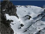 7 7 8 8 9 9 10 10 11 11 12 12 13 13 14 14 15 15 16 16 17 17
|
|
|
|
| michael6629. 03. 2010 16:46:30 |
From description, conditions not best now for "foot" to VDV (without snowshoes). Were there any "hikers" seen yesterday or is there any trodden path (if you can call it that in this warm weather). Regards.
|
|
|
|
| viharnik29. 03. 2010 19:56:31 |
On Sunday on way to summit no traces of foot mountaineers seen. Up to 1700m deep sinking, further less, sometimes none. In spring conditions snowshoes welcome for ascents at least, with which hikers walked even on Rudno Polje-Uskovnica path.
|
|
|
You must log in to post a comment:
If you do not yet have a username, you must first
register.