|
| bperc9. 07. 2011 23:17:55 |
Today I visited Kum for the first time via Škratovo Valley and was very disappointed with the unkempt trail and the trail is also very poorly marked. Maybe the markers aren't visible because the trail is so overgrown, so it needs to be cleared. So, the PD that takes care of the mentioned trail, I think it's high time you grab the "machete" and tidy up the trail.
| (+1) |  | |
|
|
|
|
| odi193m28. 07. 2011 09:15:54 |
On July 27th we visited the summit of Kum.
The previous day we checked which trail, we decided on the trail through Škratova dolina, but we shortened the trail and drove up to 500m altitude. The trail to the starting point was a steep road, first to Jelovo, an excellent asphalted road, then past St. Katarina on a narrow poor trail further, past farms first down the valley then a bit uphill. Where the trail from Zidani Most joins we leave the car and head to the summit.
Already after 200m of walking a friendly hunter addresses us. After an hour of walking, when we reach the asphalted road, a very friendly elderly lady awaits us with schnapps, we chat a bit and promise her in return to pick a bouquet of flowers which we did. The trail to the summit was pleasant, not too hot, and there was a little wind at the top. At the summit very nice view in all directions. The trail was well maintained.
Road to starting point from Radeče: 11km
ASCENT: 2:30h, 800m elevation, 6.3 km
DESCENT: 1:45h, 20m elevation, 6.3 km
 1 1 2 2 3 3 4 4 5 5 6 6 7 7 8 8 9 9 10 10 11 11 12 12 13 13 14 14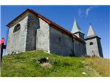 15 15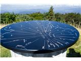 16 16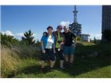 17 17
| (+2) | | |
|
|
|
|
| Janez Seliškar2. 01. 2012 16:29:48 |
This year's hike was the 30th in a row. In most cases the weather isn't favorable to hikers, this year too. Fog, icy trails and road below the summit. After a short break in the overcrowded hut we quickly head down to the valley.
 1 1 2 2
|
|
|
|
| garmont6. 03. 2012 16:55:41 |
Today I visited the king of the Zasavje hills.
With the "chick" across the Sava, then through Škratova dolina to the top of Kum. Descent to the desired station in Hrastnik, then by train to Zidani Most.
No views. You can tell it hasn't rained for a while.
Regards
| (+2) | | |
|
|
|
|
| Zalas11. 03. 2012 19:19:23 |
Today visited Kum via Čebulova dolina and have to admit that the trail through the valley is still frozen and icy, so caution is advised.
| (+1) | | |
|
|
|
|
| jprim16. 04. 2012 12:55:30 |
Some have already written that the trail to Kum is poorly marked, I agree, I don't know why it's like that in this part of our country which I like a lot, even though the weather was rather bad on Sunday. The trails around Mrzlica are very well marked though.
... via Čebulova dolina it's somehow ok, it was easier for us because we knew the trail, we did a circular hike, so we returned via Dobovec village and there we fiddled around a bit our way,(got a little lost ... ) I don't recommend that trail, since most of it is on asphalted road. ) I don't recommend that trail, since most of it is on asphalted road.
LP!
|
|
|
|
| lanževica16. 04. 2012 17:04:52 |
Yesterday to Kum starting from Podkum. From this side the trail is quite well marked. It didn't rain, but no views either. But the forest is so much nicer because everything is blooming and buzzing. The hut is open, tidy, friendly; however on the summit the viewpoint is missing, obviously someone took it away. Who would need it?
| (+3) | | |
|
|
|
|
| jprim17. 04. 2012 06:17:26 |
@lanževica
I don't know when you wandered around Kum, on Sunday it was drizzling quite often, so our camera stayed in the backpack.
LP!
|
|
|
|
| lanževica17. 04. 2012 07:10:56 |
Between eight and ten on this trail it neither rained nor drizzled. But it's true that if you decide to hike in such weather, a little drizzle won't stop you. LP!
|
|
|
|
| jprim17. 04. 2012 07:17:51 |
No, then you were earlier, we started a bit after 9 from Trbovlje.
|
|
|
|
| Žiga Šubic22. 04. 2012 20:21:04 |
After the last "rainy period" the path to Kum is already quite soggy. Across Čebulova dolina they've also started sowing grass and fertilizing, but nothing serious. On Saturday, 22. 4. 2012 there was a celebration on Kum for the Day of OF Zasavje Veterans' Organizations Participants got free goulash in the hut after the celebration, which was really great 
| (+3) | | |
|
|
|
|
| Zalas22. 04. 2012 21:14:44 |
| (+1) | | |
|
|
|
|
| jprim23. 04. 2012 12:17:44 |
Yes, today, meaning yesterday, we still observed Kum in the morning from Čemšenik Planina, views were clear and good visibility, after one hour it started, so rain and fog gave only a few meters visibility.
And I always miss when they give something for free.
LP!
| (+1) | | |
|
|
|
|
| aina29. 07. 2012 18:33:16 |
I'm interested in Nežina pot to Kum. Where exactly does it start, is it well marked, approximate walking time?
Thanks for info.
|
|
|
|
| aina8. 08. 2012 09:29:50 |
In the end we found out that Nežina pot goes from
Sopota - Solzice - Borovak - chapels of St. Neža and St. Jošt - Kum
We went from Mali Kum and took about 1 hour and did only part of Nežina pot (from St. Neža chapel onwards).
|
|
|
|
| gorski svizec4. 11. 2012 12:24:45 |
On Tuesday 30.10. we decided to check how generous winter was with snow on Kum. There was still fog in the valley and we hoped it would be different at the top. From Lontovž we took the forest path towards the summit. In the forest there were 50 cm of snow and we were the first to break trail. The path through the snowy forest was fairy-tale like. At the top almost clear sky and fairly strong wind greeted us. Views reached to Kamnik Alps and all Zasavje valleys. We descended to the valley via the road, which was drivable to the top only for off-road vehicles. We did a short but pleasant ascent to Kum in real winter, which came very early this year. Lp
| (+2) | | |
|
|
|
|
| Hribovc882. 01. 2013 22:24:49 |
On New Year's Day I ascended from Trbovlje, via Čebulova dolina to the Zasavje Triglav - Kum (1220 m), descended via Lontovž and Dobovec. Weather served me excellently all the way, only on the top there was hurricane wind. The path is mostly dry up to about 1000 m.a.s.l., only the last 100-200 elevation meters are very icy, so caution is advised.
| (+1) | | |
|
|
|
|
| bruny9. 01. 2013 20:47:08 |
I'm interested in the condition of the path - markings from Kum, via Podkum and Sv. Bric to the Sava river valley to Renke settlement and if the bridge in Renke is open for crossing the Sava?
|
|
|
|
| Boštjan MK9. 01. 2013 22:15:01 |
Officially closed, but passable with effort at own risk. Of course the train doesn't stop there for a long time.
| (+1) | | |
|
|
|
You must log in to post a comment:
If you do not yet have a username, you must first
register.