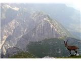
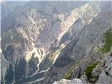
 | Vršič - Prisank / Prisojnik (Slovenian way)
Prisank is a 2547 m high mountain located above the valleys of Mlinarica, Krnica and Suha Pišnica. From the top of the peak, where the registrati...
3 h 30 min |
| Erjavčeva koča na Vršiču - Prisank / Prisojnik (Slovenska pot)
Prisank is a 2547 m high mountain located above the valleys of Mlinarica, Krnica and Suha Pišnica. From the top of the peak, where the registrati...
3 h 45 min |
 | Planina Podvežak - Planjava (via Srebrno sedlo)
Planjava is a small mountain range to the east of Kamnik saddle. It has two peaks, one eastern and one western. There is a marked trail to the ea...
4 h 15 min |
 | Planina Podvežak - Planjava (via Škarje)
Planjava is a small mountain range to the east of Kamnik saddle. It has two peaks, one eastern and one western. There is a marked trail to the ea...
4 h 45 min |
 | Kriška planina - Kalška gora (via Zvoh)
Kalška gora is located between Kalški greben and Kokrsko sedlo. From the top, which is covered with grass, there is a beautiful view towards the ...
4 h 45 min |
| Dom na Gospincu - Kalška gora (via Zvoh)
Kalška gora is located between Kalški greben and Kokrsko sedlo. From the top, which is covered with grass, there is a beautiful view towards the ...
4 h 45 min |
| Planina Jezerca - Kalška gora (via Dom na Krvavcu and Zvoh)
Kalška gora is located between Kalški greben and Kokrsko sedlo. From the top, which is covered with grass, there is a beautiful view towards the ...
5 h |
 | Planina Podvežak - Ojstrica (via Mala Ojstrica)
Ojstrica, named after its sharp shape, rises steeply above the Korošica River, the Logar Valley and Robanov Kot. From the top, where the registra...
3 h 30 min |
| Planina Ravne - Ojstrica (via Mala Ojstrica)
Ojstrica, named after its sharp shape, rises steeply above the Korošica River, the Logar Valley and Robanov Kot. From the top, where the registra...
4 h 15 min |
| Planina Ravne - Ojstrica (via Dolga trata and Mala Ojstrica)
Ojstrica, named after its sharp shape, rises steeply above the Korošica River, the Logar Valley and Robanov Kot. From the top, where the registra...
4 h 45 min |
| Kraljev dol - Ojstrica (via Mala Ojstrica)
Ojstrica, named after its sharp shape, rises steeply above the Korošica River, the Logar Valley and Robanov Kot. From the top, where the registra...
3 h 45 min |
 | Kriška planina - Kalški greben (via Zvoh)
Kalški greben is 2224 m high and is the highest peak of the eponymous ridge. The summit, which has a registration box and a stamp, offers a beaut...
4 h 10 min |
| Dom na Gospincu - Kalški greben (via Zvoh)
Kalški greben is 2224 m high and is the highest peak of the eponymous ridge. The summit, which has a registration box and a stamp, offers a beaut...
4 h 10 min |
| Planina Jezerca - Kalški greben (via Dom na Krvavcu and Zvoh)
Kalški greben is 2224 m high and is the highest peak of the eponymous ridge. The summit, which has a registration box and a stamp, offers a beaut...
4 h 25 min |
 | Jochalm - Reißkofel (path 235)
Reißkofel is a 2371 metre high mountain in the Zilj Alps. The summit on which the cross stands also has a registration box. The view from the top...
3 h 25 min |
 | Göriach - Scharnock
Scharnock is a scenic peak located in the Schladminger Tauern mountain group. From the summit on which the cross stands, there is a beautiful vie...
3 h 30 min |
 | Planina Pecol - Strma peč / Monte Cimone (path 640 via notch Vandul)
Strma peč is located to the west of Jôf di Montasio, specifically between the Reklanica and Dunja valleys. From the summit, where the bivouac onc...
4 h |
 | Planina Pecol - Strma peč / Monte Cimone (path 641 on the slope of Viene)
Strma peč is located to the west of Jôf di Montasio, specifically between the Reklanica and Dunja valleys. From the summit, where the bivouac onc...
4 h 45 min |
 | Bergheimat - Dachskofel (via Scharnik)
Dachskofel is a 2373m high mountain in Hohe Tauern in Austria above the city of Irschen and near the Lamnitzsee. A wooden cross is placed on the ...
3 h 50 min |
 | Passo di Sant'Antonio - Monte Aiarnola (via normale)
Monte Aiarnola is a mountain in the easternmost part of the Sexten Dolomites group. It offers a fine view of the western Carnic Alps, the Marmaro...
3 h 30 min |
 | Kühtai - Finsteltaler Schartenkopf (zahodni pristop iz Kühtaia in čez sedlo Finstertal)
(Finsteltaler) The Schartenkopf is an peak in the mountains above Kühtai, which is rather nondescript from the Finstertal saddle, from where it i...
4 h |
 | Sella di Razzo - Bivera (via Forcella Chiansaveit, Monte Clapsavon, Forcella de Bivera)
Monte Bivera is a 2474 m high mountain in Carnic Alps in Italy, and it is situated just short of 1 hour hiking distance to the east from Monte Cl...
4 h |