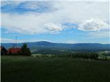
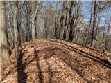
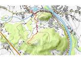
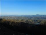
 | Ljubljana (Šentvid) - Toško Čelo
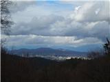
Toško Čelo is a 590 m high hill above the village of the same name. From the top, or slightly lower down, you have a beautiful view of part of Lj...
1 h 45 min |
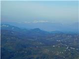
 | Za koridorjem - Sabotin (on ridge)
Sabotin is hill above Nova Gorica or more accurate above Solkan. Altough its low attitude it is great outlook with sight to Julian Alps, river So...
1 h 15 min |
 | Griže - Dragov dom na Homu (direct path)
Drago's home is located on a scenic hill, south of Šempeter. From the top, which is also the Church of St. Magdalene, there is a beautiful view f...
1 h 30 min |
| Griže - Dragov dom na Homu (via Zahom)
Drago's home is located on a scenic hill, south of Šempeter. From the top, which is also the Church of St. Magdalene, there is a beautiful view f...
1 h 50 min |
| Griže - Dragov dom na Homu (via Lajnarjev hrib)
Drago's home is located on a scenic hill, south of Šempeter. From the top, which is also the Church of St. Magdalene, there is a beautiful view f...
1 h 40 min |
| Šešče pri Preboldu - Dragov dom na Homu (Brdovska pot)
Drago's home is located on a scenic hill, south of Šempeter. From the top, which is also the Church of St. Magdalene, there is a beautiful view f...
1 h 15 min |
 | Lopata - Planinski dom Šentjungert
The mountain lodge is located just a few metres below the top of Gora, on which the Church of St Kunigunde, built in the 14th century, stands. Th...
1 h 30 min |
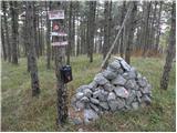
 | Lokvica - Veliki vrh (Črni hribi)
Veliki vrh is a 463 m high peak located in the ridge of the Black Hills. The summit, where the registration box is located, has no view due to th...
1 h 30 min |
 | Lokvica - Renški vrh
Renški vrh is a 449 m high hill located in the heart of the Black Hills ridge. The summit, which houses a registration box and a dilapidated benc...
1 h 55 min |
 | Komare doline - Kuk
Kuk (also Ščukovec on some maps) is a 498 m high hill located north of the village of Movraž. From the top, where a small cross stands, you can e...
1 h 15 min |
 | Komare doline - Veliki Gradež
Veliki Gradež is a 507 m high hill located between Zazid and Movraz. From the top, set amidst vast pastures, you can enjoy a beautiful view of th...
1 h 30 min |
 | Pliskovica - Volnik
Volnik or Monte Lanaro in Italian is a 546 m high hill located near the village of Pliskovica in the Karst. It is topped by a small tower and off...
1 h 30 min |
 | Svečina - Plački vrh
Plački vrh is a peak in Slovenske Gorice. It lies in the municipality of Kungota, right on the border with Austria.It has a 28-metre-high lookout...
1 h 35 min |
 | Skaručna - Smledniški hrib (Stari grad) (via Zapoški hrib)
The Old Castle (also Smlednik Castle) is located on a small hill south-west of Valburg. A few years ago, the castle was rebuilt and the nearby tr...
1 h 40 min |
 | Dragomer - Strmca (via Debeli hrib)
Strmca is a lesser-known and forested hill located between Brezje pri Dobrovi and Log pri Brezovici. There is no view from the top due to the for...
1 h 15 min |
 | Grgar - Frančiškov hrib
Frančiškov hrib is a less prominent peak located on Skalnica, whose highest peak is the 681-metre Sveta Gora. From the lookout peak, on which the...
1 h 15 min |
 | Dobrnič - Trebni vrh (via Šahovec)
Trebni vrh is a 581-metre-high hill located south or south-west of Trebnje. On the top of the forested hill there is a bench, and near it there i...
1 h 45 min |
 | Brezje pri Dobrovi - Vrh (Debeli hrib) (via Strmca)
The summit is a 540 m high hill located on the Debeli hrib ridge, a ridge situated between the Ljubljana Marshes and the Horjulščice River valley...
1 h 15 min |
 | Zagrad - Vipota (via crossing Ivankovič)
Vipota is a 532-metre-high peak south of Celje, above the left bank of the Savinja. Approaches to the summit are possible from several directions...
1 h 15 min |
 | Treskavac - Obzova
Obzova is the highest point on the island of Krk. Like the surrounding area, the peak is completely rocky. Interesting are the puddles near the t...
1 h 30 min |
 | Štore - Turn (Sv. Janez Krstnik) (via Kompole)
Turn is a peak above Štorá - Šentjanž nad Štorami. Slightly below the summit, on the site of the former Prežin Castle, the Church of St. John the...
1 h 15 min |
 | Ljubljana (Gruberjeva brv) - Orle
Orle is a locality in the municipality of Lavrica, located on a small hill northeast of the Ljubljana Mor. A few metres below the highest point o...
1 h 45 min |
 | Rdeči Kal - Ostri vrh (above Globodol) (via Velika raven)
Ostri vrh is a 523 m high peak located between Vrbovec, Rdeči Kal, Gorenji, Sredni and Dolenji Globodol, Dolni and Gorni Ajdovec and Podlipa. The...
1 h 15 min |
 | Bridge over Dušica - Bajturn (Zaplaški hrib) (on ridge)
At 609 metres, Bajturn or Zaplaz Hill is the highest peak in the municipality of Trebnje. At the top there is a nice bench with a table, a box wi...
1 h 20 min |
| Bridge over Dušica - Bajturn (Zaplaški hrib) (on north slope)
At 609 metres, Bajturn or Zaplaz Hill is the highest peak in the municipality of Trebnje. At the top there is a nice bench with a table, a box wi...
1 h 30 min |
| Okrog (Lazar) - Bajturn (Zaplaški hrib) (on ridge)
At 609 metres, Bajturn or Zaplaz Hill is the highest peak in the municipality of Trebnje. At the top there is a nice bench with a table, a box wi...
1 h 30 min |
| Okrog (Lazar) - Bajturn (Zaplaški hrib) (on north slope)
At 609 metres, Bajturn or Zaplaz Hill is the highest peak in the municipality of Trebnje. At the top there is a nice bench with a table, a box wi...
1 h 40 min |
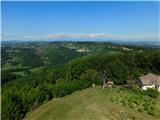
 | Otočec - Sveta Marija (Trška Gora) (via Stari grad)
Trška gora is one of Slovenia's most famous wine mountains, where the southern slope is home to the world's largest number of farmhouses and wher...
1 h 15 min |
 | Bad Gleichenberg (Sägewerk Weiss) - Stradner Kogel
Stradner Kogel is the highest hill in south-eastern Styria. The hill is of volcanic origin, and its vegetation prevents views in any direction. O...
1 h 15 min |
 | Naraplje - Jelovice
Jelovice with a height of 623 metres - the highest peak of the Haloze hills. The summit is accessible from several directions. It is partially vi...
1 h 40 min |
| Stogovci (Vabča vas) - Jelovice
Jelovice with a height of 623 metres - the highest peak of the Haloze hills. The summit is accessible from several directions. It is partially vi...
1 h 40 min |
 | Gorjuša - Sveta Trojica (above Dob) (via Dobovlje)
Sveta Trojica is a village located southeast of Dob at Domžale, and the Church of the Holy Trinity stands on the upper part of the village, on a ...
1 h 50 min |
 | Zgornje Poljčane - Ljubična gora
Ljubična gora is a hill located above Ljubično, Zbelovo and Zbelovo Gora. The hill is hidden in the forest and is not very visible, but the churc...
1 h 15 min |
 | Puštal (Na Dobravi) - Sveti Andrej (above Zminec)
The Church of St Andrew is located on a hill overloking the village of Sv. The church offers a beautiful view of Škofjeloško and Polhograjsko hri...
1 h 15 min |
 | Hunting cottage Muljava - Mali Petrovac (Petrova gora) (via Mali Velebit)
Mali Petrovac is a rather low hill located somewhere on the border between Banja and Kordun, Pannonian Croatia and Gorski Kotar. The top is compl...
1 h 15 min |
 | Stogovci (Vabča vas) - Kerješetov vrh
Kerješetov vrh is a 590-metre-high hill located above Jelovice. The hill is covered with forest, and the view is second to none....
1 h 30 min |
 | Wildon - Buchkogel (Wildoner Berg)
Buchkogel or Wildoner Berg is a 550 m high hill in the south of Styria, Austria. Together with the Wildoner Schlossberg (450 m) and the Bockberg ...
1 h 30 min |
 | Bad Gleichenberg (Eichgraben Weg) - Gleichenberger Kogel (via Steinriegel)
The Gleichenberger Kogel is a 598-metre-high volcanic mountain located above Bad Gleichenberg in Styria, Austria....
1 h 55 min |
 | Bad Gleichenberg (Eichgraben Weg) - Bschaidkogel (via Steinriegel)
...
1 h 30 min |
 | Podčetrtek (Terme Olimia) - Zavetišče Šmarnica na Mali Rudnici (mimo gradu Podčetrtek)
...
1 h 15 min |
 | Olimje - Zavetišče Šmarnica na Mali Rudnici
...
1 h 45 min |
| Slake (cerkev Device Marije na Pesku) - Zavetišče Šmarnica na Mali Rudnici
...
1 h 35 min |
 | Podčetrtek (sveti Lovrenc) - Silavec (Stolp zdravja in veselja na Rudnici) (mimo gradu Podčetrtek)
...
1 h 25 min |
| Podčetrtek (sveti Lovrenc) - Silavec (Stolp zdravja in veselja na Rudnici) (lažja pot)
...
1 h 15 min |
| Podčetrtek (sveti Lovrenc) - Silavec (Stolp zdravja in veselja na Rudnici) (težja pot)
...
1 h 15 min |
| Spodnje Tinsko - Silavec (Stolp zdravja in veselja na Rudnici)
...
1 h 20 min |
| Olimje - Silavec (Stolp zdravja in veselja na Rudnici) (mimo Koče pri čarovnici)
...
1 h 45 min |
| Olimje - Silavec (Stolp zdravja in veselja na Rudnici) (težja pot)
...
1 h 35 min |
| Olimje - Silavec (Stolp zdravja in veselja na Rudnici) (lažja pot)
...
1 h 35 min |
| Slake (cerkev Device Marije na Pesku) - Silavec (Stolp zdravja in veselja na Rudnici) (težja pot)
...
1 h 25 min |
| Slake (cerkev Device Marije na Pesku) - Silavec (Stolp zdravja in veselja na Rudnici) (lažja pot)
...
1 h 25 min |
 | Žena Glava - Sveti Duh (Hum)
...
1 h 45 min |
 | Zgornje Poljčane - Rančka
...
1 h 25 min |
 | Olimje - Olimska gora (mimo Zmajevega jezera)
...
1 h 25 min |