 | Selo - Tošč
Tošč, which became the highest peak of Polhograjsko hribovje decades ago when Pasja ravan was lowered by 9 m by the Yugoslav army, is located nor...
1 h |
 | Martinjak - Slivnica
Slivnica is a 1114 m high peak located north of Cerknica polje. The view from the summit, where the entry box is located, is rather limited due t...
1 h 15 min |
| Grahovo - Slivnica
Slivnica is a 1114 m high peak located north of Cerknica polje. The view from the summit, where the entry box is located, is rather limited due t...
1 h 15 min |
 | Radlek - Slivnica
Slivnica is a 1114 m high peak located north of Cerknica polje. The view from the summit, where the entry box is located, is rather limited due t...
1 h 20 min |
 | Volovljek - Kranjska reber
Kranjska reber or Peak Kašna planina (1435 m) is a volcanic mountain. From the top, where the registration box with the stamp is located, we have...
1 h 20 min |
 | Črnivec - Kranjska reber
Kranjska reber or Peak Kašna planina (1435 m) is a volcanic mountain. From the top, where the registration box with the stamp is located, we have...
1 h 30 min |
 | End of road - Lepenatka
Lepenatka is a grassy peak located south of the 1557 m high Rogatec. From the top, which has a registration box and a stamp, we have a beautiful ...
1 h |
 | Javorje - Stari vrh (via Prehodi)
Stari vrh is a 1217 m high mountain located above the ski resort of the same name. There is no view from the summit itself due to the forest, but...
1 h 30 min |
 | Potoki - Ajdna
Ajdna is a peak with a beautiful view of Hochstuhl, Jelovica, Pokljuka and the Julian Alps. Part of the Gornjesavska valley between Žirovnica and...
1 h |
 | Koroška Bela - Ajdna
Ajdna is a peak with a beautiful view of Hochstuhl, Jelovica, Pokljuka and the Julian Alps. Part of the Gornjesavska valley between Žirovnica and...
1 h 30 min |
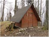
 | Predmeja - Mali Modrasovec
Mali Modrasovec is a peak north of the house on Čavno in the Trnovo forest. On the top, surrounded by wods, there is a small house and a control ...
1 h 25 min |
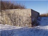 | Predmeja - Veliki Modrasovec (by road)
Veliki Modrasovec is located in the southern part of the Trnovo Forest near Predmeja. On the top of the hill is an old military building which yo...
1 h 20 min |
 | Kupljenik - Babji zob
Babji zob is a lookout point above the village of Kupljenik near Bled. The precipitous peak, which has a registration box, has a beautiful view o...
1 h 30 min |
 | Volče - Vremščica
Vremščica is a mountain chain, stretching between Senožeče, Pivka and Divača. The highest top is also called Vremščica and the view from it is am...
1 h 30 min |
 | Loščica - Vremščica
Vremščica is a mountain chain, stretching between Senožeče, Pivka and Divača. The highest top is also called Vremščica and the view from it is am...
1 h 15 min |
 | Podmeja - Mrzlica
Mrzlica has become an extremely popular excursion point in the last few years, especially for visitors from the Savinjska Valley and Zasavje. At ...
1 h 15 min |
 | Podmeja - Mrzlica
Mrzlica has become an extremely popular excursion point in the last few years, especially for visitors from the Savinjska Valley and Zasavje. At ...
1 h 15 min |
 | Planinski dom pri Gospodični - Trdinov vrh
Trdinov vrh is the highest point in the Gorjance mountain range. The view from the top is poor due to the forest, but you can still see part of t...
50 min |
 | Avsa - Mrzli vrh (on Matajur) (old path)
Mrzli vrh is a 1358-metre high peak located in the Matajur Mountains. From the top, where there is a viewing platform and a registration box with...
1 h 25 min |
 | Prvine - Črni vrh (Čemšeniška planina)
Črni vrh is the highest peak of Čemšeniška mountain pasture and with a height of 1204 m it is the second highest peak in the Posavje - Zasavje hi...
1 h |
| Čemšenik - Črni vrh (Čemšeniška planina)
Črni vrh is the highest peak of Čemšeniška mountain pasture and with a height of 1204 m it is the second highest peak in the Posavje - Zasavje hi...
1 h 30 min |
 | Planinski dom Vrhe - Črni vrh (Čemšeniška planina)
Črni vrh is the highest peak of Čemšeniška mountain pasture and with a height of 1204 m it is the second highest peak in the Posavje - Zasavje hi...
1 h 30 min |
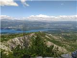
 | Skadanščina - Slavnik
Slavnik is a scenic mountain rising south of Kozina and west of Podgorje. Podgorje is a village which is a suitable starting point for ascending ...
1 h 30 min |
 | Studeno - Gora (Sveti Lovrenc)
Gora, or Sveti Lovrenc, is a peak above Studeni. It is a village north of Postojna, which is also a good starting point for climbing to the top o...
1 h 5 min |
 | Gorenje - Gora (Sveti Lovrenc)
Gora, or Sveti Lovrenc, is a peak above Studeni. It is a village north of Postojna, which is also a good starting point for climbing to the top o...
1 h 15 min |
 | Vlačno - Sveta Trojica
Sveta Trojica is a scenic peak located south-west of Javorniki. From the top, where the ruins of the former church are well preserved, you can en...
1 h 20 min |
 | Kalce - Veliki Javornik (Javorniki)
Veliki Javornik is a 1,268-metre-high peak in the forested hills called the Javorniki. The vast forests of the Javorniki stretch from Postojna to...
1 h 30 min |
 | Sovodenj - Bevkov vrh (steep way)
Bevkov vrh, which is a point on the Slovenian mountain trail, is located between Cerkno and Spodnja Idrija. The summit is covered with forest and...
1 h 15 min |
| Sovodenj - Bevkov vrh (gentle path)
Bevkov vrh, which is a point on the Slovenian mountain trail, is located between Cerkno and Spodnja Idrija. The summit is covered with forest and...
1 h 30 min |
 | Podlanišče - Bevkov vrh
Bevkov vrh, which is a point on the Slovenian mountain trail, is located between Cerkno and Spodnja Idrija. The summit is covered with forest and...
1 h 30 min |
 | Jazne (Lanišar) - Sivka
Sivka is a forested peak located west of Žiri and north of Idrija. On the summit there is a stamp of the Slovenian mountain trail and a registrat...
1 h 30 min |
 | Ledinsko Razpotje - Sivka
Sivka is a forested peak located west of Žiri and north of Idrija. On the summit there is a stamp of the Slovenian mountain trail and a registrat...
1 h 15 min |
 | Hunting cottage Gozdnik - Gozdnik
Gozdnik is a hill rising steeply above the village of Zabukovica. There is no view from the top, due to the forest, but there is a bivouac on it,...
1 h 10 min |
 | Zagreben (pri Dikcu) - Gozdnik
Gozdnik is a hill rising steeply above the village of Zabukovica. There is no view from the top, due to the forest, but there is a bivouac on it,...
1 h 30 min |
 | Kamna gora - Stolpnik
At 1012 m, Stolpnik is the highest peak of the Konjiška Gora, a mountain range stretching south-west from Slovenske Konjice. A 25 m high lookout ...
1 h |
 | Čretvež - Stolpnik (via Hunting cottage Štepih)
At 1012 m, Stolpnik is the highest peak of the Konjiška Gora, a mountain range stretching south-west from Slovenske Konjice. A 25 m high lookout ...
1 h 25 min |
 | Jurišče - Kršičevec
Kršičevec is a lesser known mountain located east of the village Jurišče in the Pivka Basin. From the grassy summit, where there is a registratio...
1 h 30 min |
 | Preval Vrh Ravni - Kojca
Kojca is a scenic peak rising south of Baška Grape. The hay pile on the top offers a beautiful view of the Lower Bohinj Mountains, the Škofjelošk...
1 h 20 min |
 | Črni Vrh - Čelkov vrh
Čelkov vrh is a 1106m high peak located to the south of Črni vrh. From the summit, which has a registration box and a stamp, there is a beautiful...
1 h 30 min |
 | Zadlog - Špičasti vrh
Špičasti vrh is a forested mountain located south of the village of Zadlog. To ensure that the peak is not without a view, a 13m high wooden look...
1 h 15 min |
 | Cenc - Špičasti vrh (on marked path)
Špičasti vrh is a forested mountain located south of the village of Zadlog. To ensure that the peak is not without a view, a 13m high wooden look...
1 h 30 min |
 | Podkraj - Križna gora (Hrušica) (steep way)
Križna gora is a 1162 m high peak located north of the village of Podkraj. From the top of the lookout tower, you can enjoy a beautiful view over...
1 h |
| Podkraj - Križna gora (Hrušica) (gentle path)
Križna gora is a 1162 m high peak located north of the village of Podkraj. From the top of the lookout tower, you can enjoy a beautiful view over...
1 h 20 min |
 | Podkraj - Sveti Duh (Hrušica)
The Sveti Duh Church is located just a few metres below the eponymous peak on the slopes of the forested Hrušice, a mountain range between Col, L...
1 h 15 min |
| Podkraj - Srednja gora (Hrušica) (east path)
Srednja gora is a 1275 m high peak located in the central part of the forested Hrušice. The peak is covered with forest, and just a few minutes w...
1 h 30 min |
 | Podkraj - Streliški vrh (Hrušica) (east path)
Streliški vrh is a 1266 m high mountain located in the central part of the forested Hrušice. From the top, which is partly covered with forest, w...
1 h 30 min |
| Podkraj - Streliški vrh (Hrušica) (west path)
Streliški vrh is a 1266 m high mountain located in the central part of the forested Hrušice. From the top, which is partly covered with forest, w...
1 h 20 min |
 | Podmeja - Sveta planina (Partizanski vrh)
Sveta planina, also Partizanski vrh, is a 1011 m high mountain located between Čemšeniška mountain pasture and Mrzlica. From the top, where a sma...
1 h 30 min |
 | Ravne - Cerk
At 1192 m, Cerk is the highest peak of Borovška Gora, a mountain range located between the Kolpa River valley and Goteniškje Snežnik. From the to...
1 h 30 min |
 | Kalce - Mali Javornik (Javorniki)
Mali Javornik is a 1219 m high mountain located in the crest of the forested Javorniki Ridge. There is no view from the top due to the forest, bu...
1 h |
 | Sovodenj - Štor (through Miklavževa grapa)
Štor is a 1005 m high peak located directly above the Ermanovec Cottage. The peak itself is covered with forest, but from the meadow, which is on...
1 h 25 min |
 | Jereka - Vodnikov razglednik
Vodnikov razglednik is a 1017-metre high mountain located between Jereka and Koprivnik in Bohinj. From the top, where there is a large cross and ...
1 h 15 min |
 | Source of Ljubija - Sveti Križ above Bele Vode
Sveti Križ is a scenic mountain located above Beli Voda. From the top, which is home to a number of church buildings and a conversion tower, we h...
1 h 5 min |
| Bele Vode (Sveti Andrej) - Sveti Križ above Bele Vode (lower path)
Sveti Križ is a scenic mountain located above Beli Voda. From the top, which is home to a number of church buildings and a conversion tower, we h...
1 h 15 min |
 | Dražgoše (Na Pečeh) - Dražgoška gora
Dražgoška gora is located on the southern slopes of Jelovica and covers quite a large area to the north-west of Dražgoš. The name Dražgoška gora ...
50 min |
 | Dom na Paškem Kozjaku - Štrukljev vrh
Štrukljev vrh is one of the three main peaks of Paški Kozjak, a 10 km long, narrow and very steep limestone mountain range between the Paka and H...
1 h 30 min |
 | Dom na Paškem Kozjaku - Ostrica
Ostrica is an undistinguished peak of Paški Kozjak, a 10 km long and rather narrow steep limestone mountain range between the Paka and Hudinja go...
1 h |
 | Čemernica / Tschemernitzen - Arihova peč / Arichwand
Arihova peč is a scenic rock cliff located near the Blesščeče mountain pasture / Rossalm. There is a wooden hut at the top of the cliff and the c...
1 h 25 min |
 | Avsa - Srednji vrh (on Matajur) (old path)
Srednji vrh is a 1320-metre high grassy peak located in the Matajur mountain range. The summit, which is a take-off point for paragliders, offers...
1 h 20 min |
 | Malenski Vrh - Malenski vrh
Malenski vrh is a 1051 m high mountain located west of Javorje. A small bench and cairn are located at the top, and the view of the surrounding h...
1 h 5 min |
| Dolenčice - Malenski vrh
Malenski vrh is a 1051 m high mountain located west of Javorje. A small bench and cairn are located at the top, and the view of the surrounding h...
1 h 15 min |
 | Široko - Veliki vrh (above Lom) (direct way)
Veliki vrh is located in the NE part of the Banjška plateau, rising above the Čepovan valley, the valley of the Soča River and the valley of the ...
1 h 30 min |
 | Zelovo - Orlove stine (zahodna pot)
...
1 h 20 min |
 | Zelovo - Umac (pri Svilaji)
...
1 h 30 min |