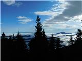
 | Kozji hrbet - Možic
Možic is a 1602 m high peak located west of Soriška mountain pasture. It is at the highest point of the peak that there is an old military bunker...
1 h |
 | Volovljek - Kranjska reber (on unmarked path)
Kranjska reber or Peak Kašna planina (1435 m) is a volcanic mountain. From the top, where the registration box with the stamp is located, we have...
1 h 15 min |
 | Bohinjsko sedlo - Slatnik (northwestern peak) (direct way)
Slatnik is a scenic mountain located to the west of the Soriška mountain pasture ski resort. The grassy peak offers a beautiful view of the Škofj...
1 h |
| Bohinjsko sedlo - Slatnik (northwestern peak) (by Lajnar)
Slatnik is a scenic mountain located to the west of the Soriška mountain pasture ski resort. The grassy peak offers a beautiful view of the Škofj...
1 h 15 min |
 | Planina Vetrh - Bela peč (via cottage Pr Zdravc)
The mountain, which is known mainly by climbers, is located north of Storžič on the slopes of Konjščice. From the top there is a beautiful view o...
1 h 15 min |
 | Križovec - Ptičji vrh
Ptičji vrh is a 1550 m high mountain located between Barentaler Kotschna and Golica. The summit, which borders between Slovenia and Austria, offe...
1 h |
 | Kajfežev rob - Kamniški vrh
Kamniški vrh is a 1259 m high mountain located north of Kamnik, between Stahovica and the Korošica Valley. From the top of the peak there is a sm...
1 h 15 min |
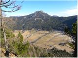
 | Planina Dol - Koritni vrh (Velika planina)
Koritni vrh is a 1648 m high mountain located in the northern part of Velika planina. From the top, on which stands a small cross, a beautiful vi...
1 h |
 | Bohinjsko sedlo - Lajnar (unmarked way)
Lajnar is a 1549 m high mountain located north of Soriška mountain pasture. From the top, which is also the highest point of the ski resort, we h...
45 min |
 | Kozji hrbet - Šavnik
Šavnik is a grassy peak located between the Soriška planina and Kobla ski resorts. From the summit, which has a registration box with a stamp, yo...
50 min |
 | Pod Hlipovcem - Veliki Travnik (Turnovka) (strma pot)
Veliki Travnik, or Turnovka as the locals call it, is located on the western edge of the Smrekov Mountains. From the top of the hill, where a woo...
50 min |
 | Planina pod Golico - Španov vrh
Španov vrh is a 1334m high mountain located between Javorniški Rovt and Mountain pasture below Golica. From the top, reached by the cable car of ...
1 h 15 min |
 | Planina Lom - Kobilja glava
Kobilja glava is a 1475 m high peak located east of Tolmin. From the top with a cross, we have a beautiful view of the Krn, the Lower Bohinj Moun...
1 h 15 min |
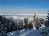
 | Koča na Gozdu - Visoki Mavrinc
Visoki Mavrinc (Špica v Sedelcih) is a 1562 m high mountain located between Suha, Mala and Velika Pišnica. From the top of the peak, where there ...
1 h 15 min |
 | Makekova Kočna - Skubrov vrh
Skubrov vrh is a 1276 m high mountain rising steeply above the Ravena Koča valley. There is no view from the forested summit....
1 h 10 min |
 | Makekova Kočna - Turni
Turni is a lesser-known peak above the cliffs of the same name, which rise above Lake Planšar. From the summit, where the registration box is loc...
1 h |
 | Matevljek - Petelinjek
Petelinjek is a 1212 m high peak located in the Racna Gora mountain range. There is no view from the summit, which is topped by a small metal cha...
1 h 15 min |
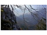 | Pri Žagi (Javorniški Rovt) - Velika Boncla
Velika Boncla is a 1241 m high, partly rocky peak located between Javorniški Rovt and mountain pasture Stamare in the Karavanke Mountains. The st...
1 h |
 | Rotek - Erbelc
Erbelc is a 1308-metre-high peak rising steeply above Zgornja Sorica. From the summit, where the registration box is located, you can enjoy a bea...
1 h 15 min |
| Spodnje Danje - Erbelc
Erbelc is a 1308-metre-high peak rising steeply above Zgornja Sorica. From the summit, where the registration box is located, you can enjoy a bea...
1 h 15 min |
 | Rotek - Tonderškofel
Tonderškofel is a 1326-metre high peak located between Soriška Peć and Erbellec. The partly overgrown peak, which has no marked trail, offers a b...
1 h 15 min |
| Spodnje Danje - Tonderškofel
Tonderškofel is a 1326-metre high peak located between Soriška Peć and Erbellec. The partly overgrown peak, which has no marked trail, offers a b...
1 h 15 min |
 | Planina pod Golico - Na pečeh at Črni Vrh
On the Peaks is a lesser-known lookout peak with an altitude of 1318 metres, rising east above the village Mountain pasture below Kahlkogel. In t...
1 h 5 min |
 | Topla (Končnik) - Šoparjev vrh
Šoparjev vrh is a 1524 m high mountain located between Olševa and Peca, more precisely on the ridge that separates the Koprivna valley from the T...
1 h 15 min |
| Koprivna (Kumer) - Šoparjev vrh
Šoparjev vrh is a 1524 m high mountain located between Olševa and Peca, more precisely on the ridge that separates the Koprivna valley from the T...
1 h 10 min |
 | Bohinjsko sedlo - Črni vrh (above Soriška planina)
Črni vrh is a fairly scenic peak located above the Bohinjski Preval. From the partially vegetated summit or the surrounding area, we have a beaut...
1 h |
 | Ravne - Bela peč (above Dovje)
Bele peči is a less known peak, located above the marked Dovje - Dovška Baba trail. The summit offers a beautiful view to the south and west, whi...
45 min |
| Erjavčev rovt - Bela peč (above Dovje)
Bele peči is a less known peak, located above the marked Dovje - Dovška Baba trail. The summit offers a beautiful view to the south and west, whi...
1 h 15 min |
 | Breitalm - Zachenkreuz
Zachenkreuz is a 1601 m high peak located above the mountain pasture Teichalm. A wooden cross stands on the summit, which is mostly covered by a ...
1 h 15 min |
 | 2nd turn of Vršič road - Škrbinjek
...
1 h |
 | Dražgoše (Jelenšče) - Britmanca
...
50 min |
| Dražgoše (Jelenšče) - Britmanca (gentle path)
...
1 h 15 min |
 | Bürgeralm (Panoramastraße) - Schönleitenhaus (Windgrube) (on southern ridge)
...
50 min |