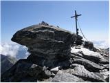
 | end of road on Pokljuka - Triglav (via Kredarica)
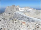
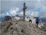
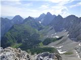
Triglav is a 2,864 m high mountain located in the heart of the Julian Alps. It is the highest mountain in Slovenia and also the highest peak in t...
6 h 15 min |
| end of road on Pokljuka - Triglav (via Planika and Mali Triglav)
Triglav is a 2,864 m high mountain located in the heart of the Julian Alps. It is the highest mountain in Slovenia and also the highest peak in t...
6 h |
 | Uskovnica (Razpotje) - Triglav (via Triglavska škrbina)
Triglav is a 2,864 m high mountain located in the heart of the Julian Alps. It is the highest mountain in Slovenia and also the highest peak in t...
6 h 25 min |
| end of road on Pokljuka - Triglav (via Planika and Triglavska škrbina)
Triglav is a 2,864 m high mountain located in the heart of the Julian Alps. It is the highest mountain in Slovenia and also the highest peak in t...
5 h 55 min |
| Rudno polje - Triglav (mimo Doma Planika in čez Triglavsko škrbino)
Triglav is a 2,864 m high mountain located in the heart of the Julian Alps. It is the highest mountain in Slovenia and also the highest peak in t...
6 h 20 min |
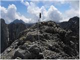
 | Rudno polje - Mali Triglav (via Dom Planika)
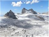
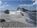
Mali Triglav is an inconspicuous peak on the main ridge of Triglav. Despite its considerable height, few hikers choose it as an independent desti...
5 h 50 min |
| Rudno polje - Mali Triglav (via Kredarica)
Mali Triglav is an inconspicuous peak on the main ridge of Triglav. Despite its considerable height, few hikers choose it as an independent desti...
6 h 5 min |
| end of road on Pokljuka - Mali Triglav (via Planika and Mali Triglav)
Mali Triglav is an inconspicuous peak on the main ridge of Triglav. Despite its considerable height, few hikers choose it as an independent desti...
5 h 25 min |
| end of road on Pokljuka - Mali Triglav (via Kredarica)
Mali Triglav is an inconspicuous peak on the main ridge of Triglav. Despite its considerable height, few hikers choose it as an independent desti...
5 h 40 min |
| Uskovnica (Razpotje) - Mali Triglav (via Planika and Mali Triglav)
Mali Triglav is an inconspicuous peak on the main ridge of Triglav. Despite its considerable height, few hikers choose it as an independent desti...
5 h 55 min |
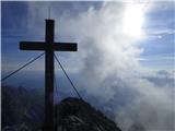
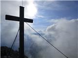
 | Sella Nevea - Visoki Kanin (Via ferrata Rosalba Grasselli)
Visoki Kanin is the highest peak of the Kanin Mountains. From the summit on which the cross stands, you have a beautiful view of the western Juli...
6 h 15 min |
 | Sella Nevea - Visoki Kanin (Via ferrata Divisione Julia)
Visoki Kanin is the highest peak of the Kanin Mountains. From the summit on which the cross stands, you have a beautiful view of the western Juli...
4 h 45 min |
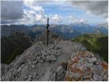
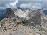
 | Koča na Gozdu - Prisank / Prisojnik (Hanzova pot)
Prisank, also known as Prisojnik, is a 2547 m high mountain located above the valleys of Mlinarica, Krnica and Suha Pišnica. From the summit, whe...
5 h |
 | Erjavčeva koča na Vršiču - Prisank / Prisojnik (Kopiščarjeva pot)
Prisank, also known as Prisojnik, is a 2547 m high mountain located above the valleys of Mlinarica, Krnica and Suha Pišnica. From the summit, whe...
4 h |
 | Erjavčeva koča na Vršiču - Prisank / Prisojnik (via Kajzljeva škrbina)
Prisank, also known as Prisojnik, is a 2547 m high mountain located above the valleys of Mlinarica, Krnica and Suha Pišnica. From the summit, whe...
5 h |
| Erjavčeva koča na Vršiču - Prisank / Prisojnik (Jubilejna pot)
Prisank, also known as Prisojnik, is a 2547 m high mountain located above the valleys of Mlinarica, Krnica and Suha Pišnica. From the summit, whe...
6 h 15 min |
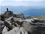
 | End of road on Pokljuka - Rjavina
Rjavina is located between two Alpine valleys. The two valleys are Kot and Krma. From the summit, which has a registration book, there is a very ...
6 h 25 min |
| Rudno polje - Rjavina
Rjavina is located between two Alpine valleys. The two valleys are Kot and Krma. From the summit, which has a registration book, there is a very ...
6 h 50 min |
 | Sporthotel Maltatal - Großer Hafner
Großer Hafner is the highest peak of the Hafner Gruppe at 3076m. From the summit on which the cross stands, there is a beautiful view across the ...
4 h 30 min |
 | Prebersee - Roteck
Roteck is a 2742m high peak located north of the Tamsweg in the heart of the Low Tatras. From the summit on which the cross stands, there is a be...
4 h |
 | Pecol - Cima di Terrarossa (Leva)
Cima di Terrarossa is a scenic peak located between Jôf di Montasio and Viš. From the summit, which is often full of ibex, you can admire the hig...
4 h 30 min |
 | Piano Fiscalino / Fischleinboden - Monte Paterno (Ferrata De Luca-Innerkofler)
Monte Paterno is a 2744 metre high lookout. The view from the top is spectacular on all sides, with the Tri Cine/Tre Cime to the west standing ou...
4 h 10 min |
 | Lienzer Dolomitenhütte - Galitzenspitzen
Galitzenspitzen is a 2710 m high mountain located in the ridge between the Roter Turm and the highest peak Lienz Dolomites Große Sandspitze. The ...
4 h |
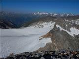
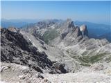
 | Sella Nevea - Foronon del Buinz / Špik nad Nosom (via Forcella Lavinal dell Orso)
Foronon del Buinz is a 2531 m high mountain located in the mountain ridge between Jôf di Montasio and Viš. The rocky peak offers a view of the Vi...
6 h |
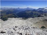
 | Sella Nevea - Vrh Krnice
Vrh Krnice is a 2441 m high peak located north-west of Visoki Kanin. From the summit, where the usually empty registration box stands, you can en...
5 h 15 min |
 | Alba di Canazei - Colac (path 646)
Colac is a 2715 m high mountain located in the west of the Marmolada mountain group. From the summit on which the cross stands, there is a beauti...
4 h |
 | La Crusc - Lavarella (via Ju dla Crusc)
Lavarella (aka La Varella) is the second highest peak in the Lavarella mountain group. From the summit on which the cross stands, you have a very...
4 h |
 | La Crusc - Piz dles Conturines
At 3064m, Piz dles Conturines is the highest peak in the Lavarella mountain group. From the summit, where the cross stands, you have a beautiful ...
5 h 30 min |
 | Parking Erichhütte - Hoher Kopf (path 432)
Hocher Kopf is located in the Berchtesgaden Alps, west of the highest peak, Höchkonig. The summit is well visited, especially because of the Köni...
4 h 45 min |
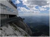 | Türlwandhütte - Hunerkogel
Hunerkogel is a 2685 metre high peak above the Schladminger Glacier. From the top you have a beautiful view of the peaks above the glacier, and y...
4 h |
 | Türlwandhütte - Kleiner Koppenkarstein (via Hunerscharte)
Kleiner Koppenkarstein is a 2,832-metre-high peak in the Dachstein mountain group. The unremarkable peak is located in the Koppenkarstein ridge, ...
4 h 15 min |
 | Türlwandhütte - Großer Koppenkarstein (via Hunerscharte)
Großer Koppenkarstein is a 2865 metre high mountain in the Dachstein mountain group. It is located above the Schladminger Glacier. From the top w...
4 h 50 min |
 | Türlwandhütte - Hoher Dachstein (via Hunerscharte)
At 2995 metres, Hoher Dachstein is the highest peak of the Dachstein mountain group. It is located on the border between Steiermark and Oberöster...
5 h 45 min |
 | Parkplatz Erichhütte - Hochkönig (path 432)
At 2941 metres, Hochkönig is the highest peak in the Berchtesgaden Alps. The summit on which the Matrashaus hut stands is very well visited. From...
5 h 20 min |
 | Türlwandhütte - Kleiner Gjaidstein (via Hunerscharte)
Kleiner Gjaidstein is a 2735 m high peak in the Dachstein mountain group. The peak is located on a ridge between the Schladminger Glacier and the...
4 h 30 min |
 | Türlwandhütte - Hoher Gjaidstein (via Hunerscharte)
Hoher Gjaidstein is a 2,792-metre-high peak in the Dachstein mountain group. The peak is located on a ridge between the Schladminger Glacier and ...
5 h |
 | Alba di Canazei - Cima Ombretta (Via Ferrata Ombretta)
Cima Ombretta is a 3011-metre peak in the Marmolada mountain group. The summit on which the cross stands offers the best view of the nearby south...
5 h 15 min |
 | Malga Fosse - Il Nuvolo (Via Ferrata Bolver Lugli)
Il Nuvolo is a 3,075-metre-high peak in the Pale di San Martino mountain group. The mountain is located above the Valle dei Cantoni, close to the...
4 h |
| Malga Fosse - Il Nuvolo
Il Nuvolo is a 3,075-metre-high peak in the Pale di San Martino mountain group. The mountain is located above the Valle dei Cantoni, close to the...
5 h 40 min |
 | Rifugio Pederü - Sasso delle Dieci / Zehnerspitze (path 12)
Sasso delle Dieci is a 3,028-metre-high mountain rising steeply above the Val Badia valley. Sasso delle Dieci is the highest peak in the Sasso de...
5 h 30 min |
| Rifugio Pederü - Sasso delle Dieci / Zehnerspitze (path 7)
Sasso delle Dieci is a 3,028-metre-high mountain rising steeply above the Val Badia valley. Sasso delle Dieci is the highest peak in the Sasso de...
5 h 35 min |
 | Ristorante Pietofana - Cima Formenton (via Rifugio Pomedes)
Cima Formenton is a 2830 m high peak in the Tofana mountain group. The mountain is located to the north of the better known Tofana di Dentro, and...
5 h 5 min |
 | Zettersfeld - Schleinitz (Klettersteig)
Schleinitz is a 2905 m high peak in the southern part of the Schober Group. The summit offers a very good view of all the major peaks in the moun...
4 h 30 min |
 | Lenzanger - Hoher Sonnblick (via Goldzechkopf)
Hoher Sonnblick aka Rauriser Sonnblick is a 3106 metre high mountain in the Goldberg mountain group. The Zittelhaus hut and the highest meteorolo...
6 h 30 min |
 | Lenzanger - Goldzechkopf (via Hoher Sonnblick)
Goldzechkopf is a 3,042-metre peak in the Goldberg Mountain Group. The peak is located on the ridge between the better known Hoher Sonnblick and ...
6 h 10 min |
 | Obermoos - Zugspitze (Stopselziehersteig)
At 2962 metres, Zugspitze is the highest peak in the Wetterstein mountain group and the highest peak in Germany. The mountain is located south of...
5 h |
 | Passo di Costalunga / Karerpass - Roda di Vael / Rotwand (Via Ferrata Majare)
Roda di Vael (German: Rotwand) is a 2806 metre high mountain in the Catinaccio (Rosengarten) mountain group. The mountain is mainly known for its...
5 h 30 min |
 | Passo di Costalunga / Karerpass - Roda di Vael / Rotwand (via Passo dal Vaiolon)
Roda di Vael (German: Rotwand) is a 2806 metre high mountain in the Catinaccio (Rosengarten) mountain group. The mountain is mainly known for its...
4 h |
 | Rifugio Gardeccia - Catinaccio d'Antermoia / Kesselkogel (via Passo di Antermoia)
Catinaccio d'Antermoia (German: Kesselkogel, Ladin: Antermoa) is the highest peak in the Catinaccio (Rosengarten) mountain group at 3004 metres a...
4 h |
 | Piano Fiscalino / Fischleinboden - Croda Rossa di Sesto (Via Ferrata Croda Rossa)
Croda Rossa di Sesto (German: Sextner Rotwand, also Zehner) is a 2,965-metre-high mountain in the Sexten Dolomites (Dolomiti di Sesto). The mount...
5 h |
 | Plockenpass - Pilastro del Coglians
Pilastro del Coglians is a 2750 m high peak located east of Monte Coglians on the border between Austria and Itali. There is also a registration ...
4 h 30 min |
| Rifugio Tolazzi - Pilastro del Coglians (via Rifugio Marinelli)
Pilastro del Coglians is a 2750 m high peak located east of Monte Coglians on the border between Austria and Itali. There is also a registration ...
3 h 55 min |
 | Rifugio Padova - Cima Montanel (via Forcella di Crodon)
Cima Montanel is a 2,461-metre-high peak overloking the Piave Valley in the Carnioan Pre-Alps. The summit on which the cross is erected is a rema...
4 h 50 min |
 | Rifugio Pederü - Cima Nove / Neunerspitze
The Italian Cima Nove or Sasso delle Nove, the German Neuner or Neunerspitze, the Ladin Sas dles Nü or Nönör is a 2,968-metre high peak in the Fa...
4 h 50 min |
 | Passo Campolongo - Piz Lech Dlace (Via Ferrata Vallon)
Peak Piz Lech Dlace (German: Eisseespitze, Italian: Piz Lago Gelato) is located above Lech Dlace Lake (German: Eissee, Italian: Lago Gelato) to t...
4 h |
 | Plöckenpass - Creta di Collina / Kollinkofel (path 171)
Creta di Collina (German: Kollinkofel) is a 2,691-metre-high mountain in Carnic Alpsah. Several military trails and ruins from the First World Wa...
4 h |
 | Plöckenpass - Creta di Collina / Kollinkofel (via Cresta Verde)
Creta di Collina (German: Kollinkofel) is a 2,691-metre-high mountain in Carnic Alpsah. Several military trails and ruins from the First World Wa...
4 h |
 | Plöckenpass - Creta della Chianevate / Kellerspitzen (path 171)
Creta della Chianevate (German: Kellerspitzen) is a 2,769-metre-high peak in the central part of Carnic Alps on the border between Austria and It...
4 h 50 min |
| Plöckenpass - Creta della Chianevate / Kellerspitzen (via Cresta Verde)
Creta della Chianevate (German: Kellerspitzen) is a 2,769-metre-high peak in the central part of Carnic Alps on the border between Austria and It...
5 h |
 | Collina - Monte Volaia / Wolayer Kopf (path 141)
Italian Monte Volaia, German Wolayer Kopf is a 2470 m high peak in the main ridge Carnic Alps west of the highest peak Monte Coglians in the subg...
4 h |
 | Capanna Alpina - Vallon Bianco
Vallon Bianco (Valun Blanch in Ladin) is a 2688 metre high peak above the Valle di Fanes and Val Travenanzes. From the top, where a small cross a...
4 h 20 min |
| Sant'Uberto - Vallon Bianco
Vallon Bianco (Valun Blanch in Ladin) is a 2688 metre high peak above the Valle di Fanes and Val Travenanzes. From the top, where a small cross a...
5 h 5 min |
| Rifugio Pederü - Vallon Bianco
Vallon Bianco (Valun Blanch in Ladin) is a 2688 metre high peak above the Valle di Fanes and Val Travenanzes. From the top, where a small cross a...
4 h 40 min |
 | Capanna Alpina - Furcia Rossa III
Furcia Rossa III is a 2791 m high peak in a slightly more secluded ridge over which the Fridensweg / Via della pace leads. At the top, next to th...
4 h 30 min |
| Rifugio Pederü - Furcia Rossa III
Furcia Rossa III is a 2791 m high peak in a slightly more secluded ridge over which the Fridensweg / Via della pace leads. At the top, next to th...
4 h 50 min |
| Sant'Uberto - Furcia Rossa III
Furcia Rossa III is a 2791 m high peak in a slightly more secluded ridge over which the Fridensweg / Via della pace leads. At the top, next to th...
5 h 15 min |
 | parking lot Stupfer in Gaistal - Hohe Munde - western peak (on climbing path via western ridge)
Hohe Munde is a peak in the Mieming Mountains west of Innsbruck and the home mountain of the town of Telfs, overloked by an imposing rock fortres...
6 h 15 min |