Starting point: Sella Nevea (1170 m)
| Lat/Lon: | 46,3874°N 13,4734°E |
| |
Time of walking: 5 h 15 min
Difficulty: very difficult marked way
Ferata: B/C
Altitude difference: 1271 m
Altitude difference po putu: 1440 m
Map: Jullijske Alpe - zahodni del 1:50.000
Recommended equipment (summer): helmet, self belay set
Recommended equipment (winter): helmet, self belay set, ice axe, crampons
Views: 10.692
 | 3 people like this post |
Access to the starting point:
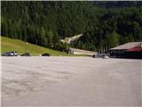
From Kranjska Gora, drive through the Rateče border crossing to Trbiž / Tarvisio. In Trbiz, turn left towards Bovec and follow the road to the crossroads near Lake Rabelj. Here, turn right towards the Nevea Pass / Sella Nevea. Follow this road, which is mostly uphill, to a large parking lot at the bottom station of the cable car leading to the Gilberti hut.
From Bovec, drive to the Predel border crossing, from which you descend to the Italian side. Just after Lake Rabelj, you will reach a crossroads where you turn left towards the Neveje Pass / Sella Nevea. Continue as described above.
Path description:
At the end of the parking lot, you will see a sign for the Gilberti mountain lodge, which will direct you to the lower part of the ski slope. Once on the slope, continue left and after a short climb, you will reach a transport rescue road that ascends up the slope. From the relatively steep road, which is closed to traffic, new views open up from one step to the next, the most beautiful of which are of the nearby Belo Pach and the Jôf di Montasio group of mountains. Higher up, the road approaches the cliffs of Bílá Peć and leads to the top station of the cable car at the Gilberti hut.
From the hut, descend gently (westwards) into a small valley, where there is a crossroads. Continue to the right in the direction of S. Grubia, following the path between the main canyon ridge on the left and the Belo Pecja on the right. The way forward initially climbs gently up the valley, then begins to climb steeply and after a few minutes of climbing leads us to an old military fortress on the Bela Peć saddle. After the fortress, continue slightly left in the direction of "bivacco" (right Bela peč 30 minutes very difficult path) on the old military mulatier, which is already well destroyed. The path, which descends slightly and then climbs again, runs along sometimes steep slopes, which are sometimes slightly precipitous and exposed to falling stones (because the path is wide in the land it does not cause any problems). The path then leads to a crossroads, where the path to Visoki Kanin branches off to the left upwards. Continue on the mulatier, which then crosses some ravines that are covered with snow long into the summer. After a 2-hour walk from the Gilberti hut, the beautiful and scenic high-mountain route leads to the Marrusich bivouac.
At the bivouac, head south-east on a narrow path that runs along the ridge and starts to climb. The path soon leads to a ridge and then ascends and descends gently a few times. Later, the path again leaves the ridge to the left and there is a short climb on scree to enter the climbing part of the path.
At first, you climb right up along a small rope to a ridge overloking the valley of the Riesen. At the ridge, continue left and climb along the steel cable for a short distance on a narrow ridge, then retreat to the north side of the ridge again. Here the path becomes very steep and climbs vertically with the help of a number of scrambles. There are a few more steep climbs along the steel and then the ridge is reached again. Further on, the path is a little less protected, but the cable is still there to help us at key points. Most of the climbing is along the ridge on the north side, but occasionally the route follows the ridge. In the last part of the route towards Vrh Krnice, the path takes us to the south side of the ridge and there is a short climb up a slightly less steep slope to the summit.

Pictures:
 1
1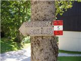 2
2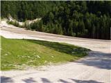 3
3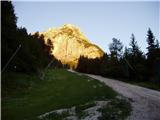 4
4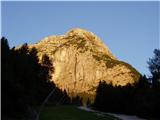 5
5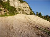 6
6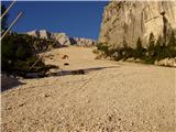 7
7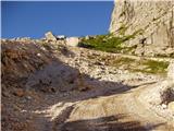 8
8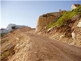 9
9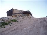 10
10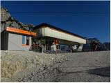 11
11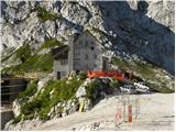 12
12 13
13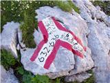 14
14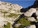 15
15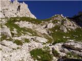 16
16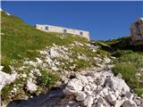 17
17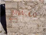 18
18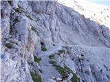 19
19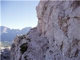 20
20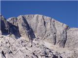 21
21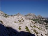 22
22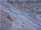 23
23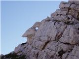 24
24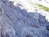 25
25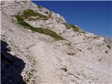 26
26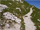 27
27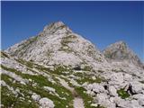 28
28 29
29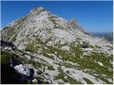 30
30 31
31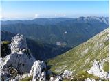 32
32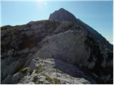 33
33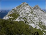 34
34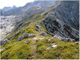 35
35 36
36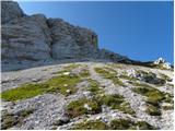 37
37 38
38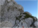 39
39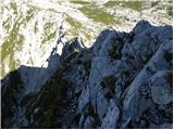 40
40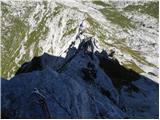 41
41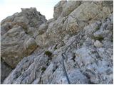 42
42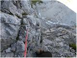 43
43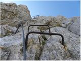 44
44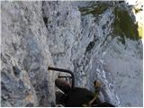 45
45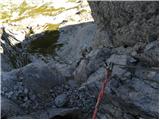 46
46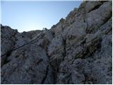 47
47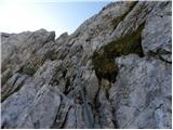 48
48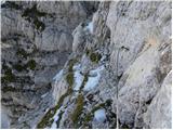 49
49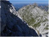 50
50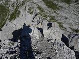 51
51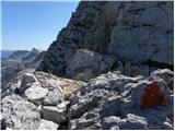 52
52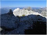 53
53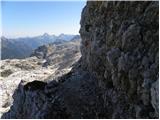 54
54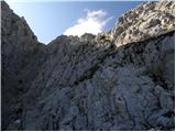 55
55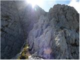 56
56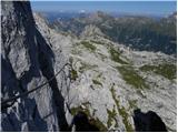 57
57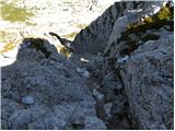 58
58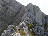 59
59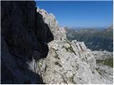 60
60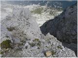 61
61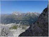 62
62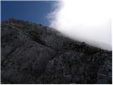 63
63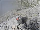 64
64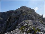 65
65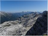 66
66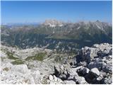 67
67 68
68
Discussion about the trail Sella Nevea - Vrh Krnice
|
| Flora112. 03. 2012 |
Ali je že kdo hodil tu? Zanimam se za to pot za poleti s podaljškom do Velikega Kanina. V knjigi 111 izletov po slov. gorah priporoča vrh kljub varovalom in me zanima, kako dobro je pot varovana. Tako da se da na vseh mestih pripeti samovarovalni komplet ali da je potrebno tudi kje plezati I/II? Berem, da je greben proti Kaninu še manj varovan. Mi zna kdo kaj več o tem povedati, prosim? Hvala.
|
|
|
|
| IgorZlodej12. 03. 2012 |
Hodili, pa ne samo enkrat, gre za del Visoke Rezijanske poti, tudi že večkrat opisano, nazadnje z moje strani 27.9.2011 pod Visoki Kanin. Sicer pa od bivaka Marušič na Vrh Krnice lepo zavarovano, naprej je pa treba malo poplezat na Visoki Kanin, prečenje po grebenu do Laške Planje pa je samo za izkušene, ni zavarovano oz. le manjši del naprej od Planje proti sedlu Med Baban.
|
|
|
|
| Flora112. 03. 2012 |
Hvala za hiter odgovor. Bom še malo prebrala tam. Z Visokega Kanina želim sestopiti, tako da grebena do Planje ne načrtujem.
ps. gor se mi je zatipkalo. priporoča vrv, ne vrh.
|
|
|
|
| mirank12. 03. 2012 |
Bil na tej poti avgusta lani; z žičnico- prva vožnja ob 8,30 do koče Gilberti. Od tam po udobni poti na sedlo med Bilo pečjo in pogorjem Kanina in naprej (rahlo levo) po vseskozi lepo prehodni mulatieri skoraj po ravnem do sedla Peravo ( bivak Marušič). Tu lahko izbiraš in greš še malo naravnost na Žrd in nazaj, ali pa takoj zaviješ ostro levo-skoraj proti nazaj po grebenu po sezici v smeri Vrha Krnice. Čez travnata in lažja pobočja prideš do začetka zavarovane poti Rosalba Graseti, ki je kar izpostavljena vendar po mojem čisto dovolj zavarovana z jeklenico (po italjansko) tako, da ni panike če si takih poti vajena. Od Vrha Krnice dalje pot poteka po velikih kamnitih ploščah kjer se pač zaneseš na trenje podplatov ker naklon ni prevelik. Pot je obilno označena, predvsem od vrha Krnice dalje, sam vzpon na vrh Kanina pa ni preveč zahteven. Vrneš se po ferati Julia (praktično nova varovalna jeklenica) na ledenik in nazaj do žičnice. Za to pot-prečkanje ledenika v dolžini cca 400m; imej s sabo dereze in cepin. Za povratek S Kanina so možne tudi druge variante-malo poglej še po drugih opisih - Srečno, in ob pravem vremenu
|
|
|
|
| Flora112. 03. 2012 |
Hvala, Miran. Super si napisal. To me je ravno zanimalo, ali je dovolj jeklenic za samovarovanje, ali se potrebuje vrv in kakšen je greben za naprej. S Kanina/z Visokega Kanina nameravam sestopiti čez Prevalo, čeprav je pot daljša. Bomo videli, kaj bo, do poletja je še daleč, a hkrati komaj čakam! Srečno.
|
|
|