 | Gozdec - Prestreljenik (via dom Petra Skalarja)
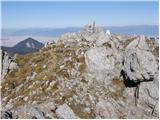
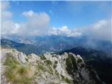
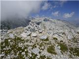
Prestreljenik is a 2499 m high mountain located in the heart of the Kanin Mountains. From the top, where the Aljaž Tower-shaped registration box ...
5 h 45 min |
| B station - Prestreljenik (via Krnica)
Prestreljenik is a 2499 m high mountain located in the heart of the Kanin Mountains. From the top, where the Aljaž Tower-shaped registration box ...
4 h 25 min |
| Sella Nevea - Prestreljenik (via Rifugio Gilberti)
Prestreljenik is a 2499 m high mountain located in the heart of the Kanin Mountains. From the top, where the Aljaž Tower-shaped registration box ...
4 h 15 min |
| Sella Nevea - Prestreljenik (via 636)
Prestreljenik is a 2499 m high mountain located in the heart of the Kanin Mountains. From the top, where the Aljaž Tower-shaped registration box ...
3 h 45 min |
 | Pišnica - Špik (via Kačji graben)
Špik is a 2472 m high mountain located in the heart of the Martuljek Group. From the top, which is clearly visible from the road leading through ...
4 h 40 min |
| Ruski križ - Špik (via Kačji graben)
Špik is a 2472 m high mountain located in the heart of the Martuljek Group. From the top, which is clearly visible from the road leading through ...
4 h 45 min |
 | The Kot Valley - Begunjski vrh
Begunjski vrh is a 2461 m high mountain located in the heart of the highest mountains in the Julian Alps. From the top, which has a registration ...
4 h 40 min |
 | Bodenbauer - Hochstuhl/Stol
Stol is, at 2236 m, the highest peak of the Karavanke. From the summit, which has a registration box and a stamp, we have a beautiful view of the...
4 h 30 min |
 | Sele-Zvrhnji Kot (Male) / Zell-Oberwinkel (Male) - Loibler Baba/Košutica (over Hajnževo sedlo)
Košutica (also known as Ljubeljska Baba) is a scenic mountain located north of the western ridge of Košuta. From the summit, where there is a sma...
4 h 15 min |
 | Bodenbauer - Vertatscha/Vrtača
Vrtača is a 2181 m high peak located east of Stol. From the summit, where a large peg stands, a beautiful view opens up of parts of the Julian Al...
4 h 45 min |
 | Jermanca - Planjava (via Kamniško sedlo)
Planjava is a small mountain range east of Kamniško sedlo. It has two peaks, eastern and western. A marked trail leads to the eastern peak, which...
4 h 30 min |
| Koča pod slapom Rinka - Planjava
Planjava is a small mountain range east of Kamniško sedlo. It has two peaks, eastern and western. A marked trail leads to the eastern peak, which...
4 h 45 min |
 | Na Razpotju - Planjava
Planjava is a small mountain range east of Kamniško sedlo. It has two peaks, eastern and western. A marked trail leads to the eastern peak, which...
5 h |
| Dom Planincev v Logarski dolini - Planjava
Planjava is a small mountain range east of Kamniško sedlo. It has two peaks, eastern and western. A marked trail leads to the eastern peak, which...
4 h 55 min |
 | The Krma Valley - Debela peč
Debela peč is a 2014 m high mountain that rises steeply above the Krma valley on one side and descends gently towards the vast Pokljuka forests o...
3 h 30 min |
 | Laško - Storžič (via Kališče)
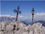
Storžič is a 2132 m high mountain located in the western part of the Kamnik-Savinja Alps. From the summit, where there is a cross, there is a bea...
3 h 30 min |
 | Laško - Storžič (via Sveti Lovrenc and over Bašeljski preval)
Storžič is a 2132 m high mountain located in the western part of the Kamnik-Savinja Alps. From the summit, where there is a cross, there is a bea...
4 h 30 min |
 | Tržiški graben - Storžič (via Javorniški preval)
Storžič is a 2132 m high mountain located in the western part of the Kamnik-Savinja Alps. From the summit, where there is a cross, there is a bea...
3 h 40 min |
| MHE Zabukovec - Storžič (via Bašeljski preval)
Storžič is a 2132 m high mountain located in the western part of the Kamnik-Savinja Alps. From the summit, where there is a cross, there is a bea...
4 h |
 | Jermanca - Brana (via Kamniško sedlo)
Brana is a mountain above Kamniško sedlo. From the spacious summit, which has a registration box and a small cross, there is a very beautiful vie...
3 h 45 min |
| Koča pod slapom Rinka - Brana
Brana is a mountain above Kamniško sedlo. From the spacious summit, which has a registration box and a small cross, there is a very beautiful vie...
3 h 45 min |
 | Belca - Mittagskogel/Kepa
Kepa, also known as Jepa or Mittagskogel in German, is a panoramic mountain in the western Karawanks, located on the border ridge between Sloveni...
4 h 15 min |
 | Erjavčev rovt - Mittagskogel/Kepa
Kepa, also known as Jepa or Mittagskogel in German, is a panoramic mountain in the western Karawanks, located on the border ridge between Sloveni...
3 h 50 min |
| Ravne - Mittagskogel/Kepa
Kepa, also known as Jepa or Mittagskogel in German, is a panoramic mountain in the western Karawanks, located on the border ridge between Sloveni...
4 h 15 min |
 | Čemernica / Tschemernitzen - Mittagskogel/Kepa
Kepa, also known as Jepa or Mittagskogel in German, is a panoramic mountain in the western Karawanks, located on the border ridge between Sloveni...
5 h 5 min |
 | Suhadolnik - Kalška gora
Kalška gora is located between Kalški greben and Kokrsko sedlo. From the top, which is covered with grass, there is a beautiful view towards the ...
3 h 30 min |
 | Na Razpotju - Ojstrica (via Škarje)
Ojstrica, named after its sharp shape, rises steeply above the Korošica River, the Logar Valley and Robanov Kot. From the top, where the registra...
4 h 15 min |
| Dom Planincev v Logarski dolini - Ojstrica (via Škarje)
Ojstrica, named after its sharp shape, rises steeply above the Korošica River, the Logar Valley and Robanov Kot. From the top, where the registra...
4 h 10 min |
 | Planina Zapleč - Krn
At 2244 m, Krn is the highest peak of the Krn Mountains, a mountain range that rises steeply above the central part of the Soča River. From the s...
4 h 30 min |
 | Koča pri Savici - Mala Tičarica
Mala Tičarica is a very scenic mountain above the Double Triglav Lake. From the top, you can enjoy a beautiful view towards the cottage at Trigla...
4 h 10 min |
 | The Kot Valley - Cmir
The mountain is located between two Alpine valleys between Vrata and the lesser-known Za Cmirom valley. From the top you can enjoy a beautiful vi...
6 h 10 min |
 | Koča pri Savici - Zasavska koča na Prehodavcih
Zasavska koča na Prehodavcih is located on a scenic peak above the Triglav Lakes Valley. The hut, which is open in the summer season, offers a be...
5 h 10 min |
 | Koča pri Savici - Pršivec
Lookout Mountain is located above Lake Bohinj. The view is extensive on all sides. Triglav and the mountains around it can be seen, and on the ot...
4 h 10 min |
 | Aljažev dom v Vratih - Križ (via Sovatna)
Križ is a 2140 m high mountain located north-east of the Kriški Podi. From the top, where there is a registration box with a stamp, you have a be...
5 h |
 | Podnar / Bodenbauer - Prešernova koča na Stolu
Prešernova koča na Stolu, is located just a few metres below the summit of the 2198 m high Mali Stol. From the hut or the nearby Mali Stol, we ha...
4 h 25 min |
 | The Kot Valley - Visoka Vrbanova špica (via Staničev dom)
Visoka Vrbanova špica, is located at the extreme south-western part of the ridge rising above the Kot and Vrata valleys, and higher up between th...
4 h 30 min |
 | Aljažev dom v Vratih - Planja (via Sovatna)
The summit is located between two Alpine valleys. On the northern side is the Mlinarica valley and on the southern side is the Zadnjica valley. F...
6 h 5 min |
 | Planina Blato - Veliko Špičje (via Štapce)
Veliko Špičje is the highest peak in the ridge from Travnik to Zasavska hut. From the top there is a very nice view over the plateaus of Komna, t...
5 h 45 min |
 | Aljažev dom v Vratih - Bovški Gamsovec (via Luknja)
Bovški Gamsovec is a 2392m high mountain in the immediate vicinity of Triglava. From the top, you can enjoy a magnificent view of Triglav and its...
4 h 35 min |
| Aljažev dom v Vratih - Bovški Gamsovec (via Sovatna)
Bovški Gamsovec is a 2392m high mountain in the immediate vicinity of Triglava. From the top, you can enjoy a magnificent view of Triglav and its...
4 h 45 min |
 | Valbruna - Jof di Miezegnot/Poldašnja špica (via Planina Ravne)
Jof di Miezegnot is the easternmost of the two-thousanders in the Naborjeta Mountains (Monti di Malborgheto) group. From the top of the mountain,...
3 h 45 min |
| Valbruna - Jof di Miezegnot/Poldašnja špica (via Planina Strehica)
Jof di Miezegnot is the easternmost of the two-thousanders in the Naborjeta Mountains (Monti di Malborgheto) group. From the top of the mountain,...
4 h |
 | Malborghetto - Jof di Miezegnot/Poldašnja špica
Jof di Miezegnot is the easternmost of the two-thousanders in the Naborjeta Mountains (Monti di Malborgheto) group. From the top of the mountain,...
4 h |
 | Bagni di Lusnizza - Cima Alta (Due Pizzi)
The two peaks (Due Pizzi) form two peaks in the Naborjeta group, namely Cima Alta (2046m) and Cima Vildiver (2008m). On both peaks there is a cro...
4 h |
| Malborghetto - Cima Alta (Due Pizzi) (path 605)
The two peaks (Due Pizzi) form two peaks in the Naborjeta group, namely Cima Alta (2046m) and Cima Vildiver (2008m). On both peaks there is a cro...
4 h 25 min |
 | Ovčja vas / Valbruna - Kamniti lovec / Cima del Cacciatore
Kamniti lovec is a popular excursion point above Trbiz. It is well visited due to its short access, which is shortened by a cable car to Višarje....
4 h |
 | Žabnice / Camporosso in Valcanale - Kamniti lovec / Cima del Cacciatore
Kamniti lovec is a popular excursion point above Trbiz. It is well visited due to its short access, which is shortened by a cable car to Višarje....
3 h 30 min |
 | Ravenska Kočna - Velika (Koroška) Baba (via Jenkova planina)
Velika is a 2127 m high mountain on the border ridge above the Ravenská Kočna valley on the Slovenian side and above the Bela valley (Belska Kočn...
3 h 30 min |
 | Sella Nevea - Velika Črnelska špica (on ski track)
Velika Črnelska špica is located in the Kanin Mountains on the border between Itali and Slovenia. From the top, you can enjoy a very nice view of...
4 h 30 min |
| Sella Nevea - Velika Črnelska špica (via 636)
Velika Črnelska špica is located in the Kanin Mountains on the border between Itali and Slovenia. From the top, you can enjoy a very nice view of...
4 h 45 min |
 | Goldberg - Torkofel
Torkofel is the highest peak of the Jauken lookout ridge, which stretches north of the Ziljska valley. From the top with a cross there is a beaut...
3 h 45 min |
 | Reißkofelbad - Reißkofel (via east ridge)
Reißkofel is a 2371 metre high mountain in the Zilj Alps. The summit on which the cross stands also has a registration box. The view from the top...
4 h 45 min |
 | Reißkofelbad - Kleiner Reißkofel
Kleiner Reißkofel is a 2161 metre high mountain east of Reißkofl. From the summit on which the cross stands, you can enjoy a beautiful view of th...
3 h 30 min |
 | Na Razpotju - Krofička (marked way)
Krofička, or Grofička according to some records, is a peak located northeast of Ojstrica. From the summit, which descends steeply towards the Log...
3 h 40 min |
| Dom Planincev v Logarski dolini - Krofička (marked path)
Krofička, or Grofička according to some records, is a peak located northeast of Ojstrica. From the summit, which descends steeply towards the Log...
3 h 35 min |
 | NC Planica - Srednja Ponca / Ponza di Mezze
Srednja Ponca is a 2228m high peak rising steeply above Tamar, Planica and the Mangart valley. From the summit on which the stamp is located, the...
4 h |
 | Aljažev dom v Vratih - Pihavec (via Sovatna)
Pihavec is a vast and scenic peak located to the south of the Kriški Podovi. From the summit, which has a registration box and a stamp, there is ...
5 h 15 min |
 | Cave del Mole - Koštrunove špice (via Forcella Lavinal dell Orso)
Koštrunove špice is a 2502 m high peak located south-west of Viš (2666 m). The summit offers a beautiful view over most of the western Julian Alp...
4 h |
| Cave del Mole - Koštrunove špice (via Forcella Mose)
Koštrunove špice is a 2502 m high peak located south-west of Viš (2666 m). The summit offers a beautiful view over most of the western Julian Alp...
4 h |
| Sella Nevea - Koštrunove špice (via Forcella Lavinal dell Orso)
Koštrunove špice is a 2502 m high peak located south-west of Viš (2666 m). The summit offers a beautiful view over most of the western Julian Alp...
4 h 30 min |
 | Parking Alpspitzbahn - Bernadeinkopf (via Osterfelderkopf)
Bernadeinkopf is a 2143 m high peak in the Wetterstein mountain group. From the summit on which the cross stands, you have a very nice view of th...
5 h 30 min |
 | Coot Parking Lot - Velika Baba (Kanin) (via Skutnik)
Velika Baba is the southernmost two-thousand-metre peak of the Kanin Mountains. It is separated from the main ridge to the north by the Med Baban...
4 h 20 min |
 | Weißenbach - Spitzegel / Negal (via Bodenalm)
Spitzegel or. Negal (in Slovene) is a 2119 m high mountain in Gailtal Alps in Austria.The narrow ridge is a logical continuation of Dobrač / Dobr...
4 h 30 min |
 | Val Aupa - Sernio (via normale)
Sernio (it. Monte Sernio / in Furlani language: Serenât or. Crede di Seregnò) is a 2187 m high mountain in Carnic Alps in Italy between the easte...
4 h 30 min |
 | Sankt Ilgen (Der Bodenbauer) - Hochschwab
...
4 h 25 min |
 | Ruski križ - Lipnica (via Koča v Krnici)
...
4 h 15 min |