 | Railway station Hochzirl - Kleiner Solstein (on Höttinger Schützensteig)
Kleiner Solstein is the highest peak of the famous Nordkette ridge barrier, which hides the central part of the Karwendel from the valley and cre...
6 h |
 | Zadnja Trenta (Flori) - Jalovec (via Jalovška škrbina)
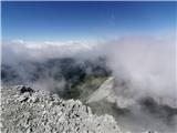
Jalovec is the sixth highest mountain in Slovenia with a height of 2645 m. The summit, which descends steeply towards three Alpine valleys (Loška...
6 h |
| Zadnja Trenta (Flori) - Jalovec (via zavetišče pod Špičkom)
Jalovec is the sixth highest mountain in Slovenia with a height of 2645 m. The summit, which descends steeply towards three Alpine valleys (Loška...
6 h |
| Vršič - Jalovec (via zavetišče pod Špičkom)
Jalovec is the sixth highest mountain in Slovenia with a height of 2645 m. The summit, which descends steeply towards three Alpine valleys (Loška...
6 h 30 min |
 | Dom v Tamarju - Jalovec (via Kotovo sedlo)
Jalovec is the sixth highest mountain in Slovenia with a height of 2645 m. The summit, which descends steeply towards three Alpine valleys (Loška...
5 h 15 min |
| Dom v Tamarju - Jalovec (via Jalovška škrbina)
Jalovec is the sixth highest mountain in Slovenia with a height of 2645 m. The summit, which descends steeply towards three Alpine valleys (Loška...
5 h 45 min |
| Dom v Tamarju - Jalovec (on scree and over Kotovo sedlo)
Jalovec is the sixth highest mountain in Slovenia with a height of 2645 m. The summit, which descends steeply towards three Alpine valleys (Loška...
5 h 15 min |
 | Parkirišče Stupfer v dolini Gaistal - Hohe Munde - western peak (po plezalni poti preko zahodnega grebena)
Hohe Munde is a peak in the Mieming Mountains west of Innsbruck and the home mountain of the town of Telfs, overloked by an imposing rock fortres...
6 h 15 min |
 | Rio Bianco - Viš/Jof Fuart (Sentiero del Centenario)
Viš is a 2666m high peak in the western Julian Alps. From the top, where the statue of St Mary and the cross stand, you can enjoy a beautiful vie...
6 h |
| Cave del Mole - Viš/Jof Fuart (Anita Goitan)
Viš is a 2666m high peak in the western Julian Alps. From the top, where the statue of St Mary and the cross stand, you can enjoy a beautiful vie...
5 h 30 min |
 | Pri Mlinču - Mangart (slovenska pot)
Mangart (also Mangrt, both spellings are grammatically correct) is a mountain that receives a very high number of visitors in summer. Access to t...
4 h 45 min |
 | Klammbrückl - Spitzkofel
Spitzkofel is a 2,717-metre-high mountain in the Lienz Dolomites. From the top, where a large cross stands, you have a very nice view of the whol...
5 h |
 | Aljažev dom v Vratih - Mali Triglav (via Prag)
Mali Triglav is an undistinguished peak in the main ridge of Triglav. Despite its great height, few people decide to set out on their own. Most o...
5 h 35 min |
| The Kot Valley - Mali Triglav
Mali Triglav is an undistinguished peak in the main ridge of Triglav. Despite its great height, few people decide to set out on their own. Most o...
5 h 35 min |
| Aljažev dom v Vratih - Mali Triglav (Tominšek route)
Mali Triglav is an undistinguished peak in the main ridge of Triglav. Despite its great height, few people decide to set out on their own. Most o...
5 h 25 min |
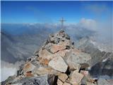
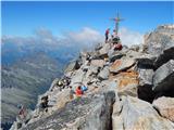
 | Aljažev dom v Vratih - Škrlatica
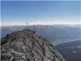
Škrlatica is the second highest mountain in Slovenia. There is a cross at the top, which makes it easy to identify the peak from neighbouring mou...
6 h |
 | Plockenpass - Pilastro del Coglians
Pilastro del Coglians is a 2750 m high peak located east of Monte Coglians on the border between Austria and Itali. There is also a registration ...
4 h 30 min |
 | Planina Zajzera - Jôf di Montasio/Montaž (Via Amalia)
Jôf di Montasio is one of the most majestic mountains in the Julian Alps and with its 2753m it is the second highest. The authentic Slovenian nam...
6 h 45 min |
 | Plöckenpass - Creta della Chianevate / Kellerspitzen (path 171)
Creta della Chianevate (German: Kellerspitzen) is a 2,769-metre-high peak in the central part of Carnic Alps on the border between Austria and It...
4 h 50 min |
| Plöckenpass - Creta della Chianevate / Kellerspitzen (via Cresta Verde)
Creta della Chianevate (German: Kellerspitzen) is a 2,769-metre-high peak in the central part of Carnic Alps on the border between Austria and It...
5 h |
 | Sant'Uberto - Furcia Rossa III
Furcia Rossa III is a 2791 m high peak in a slightly more secluded ridge over which the Fridensweg / Via della pace leads. At the top, next to th...
5 h 15 min |
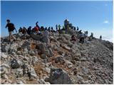
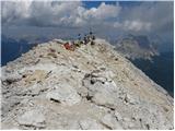
 | Aljažev dom v Vratih - Triglav (Tominšek route)
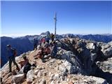
Triglav is a 2864 m high mountain located in the heart of the Julian Alps. With its height, Triglav is the highest mountain in Slovenia and the h...
6 h |
| Aljažev dom v Vratih - Triglav (via Prag)
Triglav is a 2864 m high mountain located in the heart of the Julian Alps. With its height, Triglav is the highest mountain in Slovenia and the h...
6 h 10 min |
 | Aljažev dom v Vratih - Triglav (via Plemenice)
Triglav is a 2864 m high mountain located in the heart of the Julian Alps. With its height, Triglav is the highest mountain in Slovenia and the h...
6 h 30 min |
| The Kot Valley - Triglav
Triglav is a 2864 m high mountain located in the heart of the Julian Alps. With its height, Triglav is the highest mountain in Slovenia and the h...
6 h 10 min |
| The Krma Valley - Triglav (via Kredarica)
Triglav is a 2864 m high mountain located in the heart of the Julian Alps. With its height, Triglav is the highest mountain in Slovenia and the h...
6 h 10 min |
| The Krma Valley - Triglav (via Planika and Mali Triglav)
Triglav is a 2864 m high mountain located in the heart of the Julian Alps. With its height, Triglav is the highest mountain in Slovenia and the h...
6 h |
 | The Krma Valley - Triglav (via Planika and Triglavska škrbina)
Triglav is a 2864 m high mountain located in the heart of the Julian Alps. With its height, Triglav is the highest mountain in Slovenia and the h...
5 h 45 min |
| end of road on Pokljuka - Triglav (via Kredarica)
Triglav is a 2864 m high mountain located in the heart of the Julian Alps. With its height, Triglav is the highest mountain in Slovenia and the h...
6 h 10 min |
| end of road on Pokljuka - Triglav (via Planika and Mali Triglav)
Triglav is a 2864 m high mountain located in the heart of the Julian Alps. With its height, Triglav is the highest mountain in Slovenia and the h...
6 h |
| Uskovnica (Razpotje) - Triglav (via Planika and Mali Triglav)
Triglav is a 2864 m high mountain located in the heart of the Julian Alps. With its height, Triglav is the highest mountain in Slovenia and the h...
6 h 15 min |
| Uskovnica (Razpotje) - Triglav (via Triglavska škrbina)
Triglav is a 2864 m high mountain located in the heart of the Julian Alps. With its height, Triglav is the highest mountain in Slovenia and the h...
6 h |
| Rudno polje - Triglav (via Kredarica)
Triglav is a 2864 m high mountain located in the heart of the Julian Alps. With its height, Triglav is the highest mountain in Slovenia and the h...
6 h 30 min |
| Uskovnica (Lom) - Triglav (via Triglavska škrbina)
Triglav is a 2864 m high mountain located in the heart of the Julian Alps. With its height, Triglav is the highest mountain in Slovenia and the h...
6 h 20 min |
| Rudno polje - Triglav (via Dom Planika and Mali Triglav)
Triglav is a 2864 m high mountain located in the heart of the Julian Alps. With its height, Triglav is the highest mountain in Slovenia and the h...
6 h 20 min |
 | Parking Erichhütte - Hoher Kopf (path 432)
Hocher Kopf is located in the Berchtesgaden Alps, west of the highest peak, Höchkonig. The summit is well visited, especially because of the Köni...
4 h 45 min |
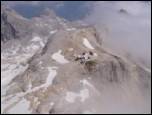
 | Parkplatz Erichhütte - Hochkönig (path 432)
At 2941 metres, Hochkönig is the highest peak in the Berchtesgaden Alps. The summit on which the Matrashaus hut stands is very well visited. From...
5 h 20 min |
 | Parkplatz Innerfragant - Alteck (via Fraganter Scharte)
Alteck is a 2942 metre high peak rising steeply above the Hochwurtenspeicher lake at the Mölltaler Glacier ski resort. From the summit, on which ...
7 h |
 | Obermoos - Zugspitze (Stopselziehersteig)
At 2962 metres, Zugspitze is the highest peak in the Wetterstein mountain group and the highest peak in Germany. The mountain is located south of...
5 h |
 | Piano Fiscalino / Fischleinboden - Croda Rossa di Sesto (Via Ferrata Croda Rossa)
Croda Rossa di Sesto (German: Sextner Rotwand, also Zehner) is a 2,965-metre-high mountain in the Sexten Dolomites (Dolomiti di Sesto). The mount...
5 h |
 | Rifugio Pederü - Cima Nove / Neunerspitze
The Italian Cima Nove or Sasso delle Nove, the German Neuner or Neunerspitze, the Ladin Sas dles Nü or Nönör is a 2,968-metre high peak in the Fa...
4 h 50 min |
 | Alba di Canazei - Cima Ombretta (Via Ferrata Ombretta)
Cima Ombretta is a 3011-metre peak in the Marmolada mountain group. The summit on which the cross stands offers the best view of the nearby south...
5 h 15 min |
 | Rifugio Pederü - Sasso delle Dieci / Zehnerspitze (path 12)
Sasso delle Dieci is a 3,028-metre-high mountain rising steeply above the Val Badia valley. Sasso delle Dieci is the highest peak in the Sasso de...
5 h 30 min |
| Rifugio Pederü - Sasso delle Dieci / Zehnerspitze (path 7)
Sasso delle Dieci is a 3,028-metre-high mountain rising steeply above the Val Badia valley. Sasso delle Dieci is the highest peak in the Sasso de...
5 h 35 min |
 | Lenzanger - Goldzechkopf (via Hoher Sonnblick)
Goldzechkopf is a 3,042-metre peak in the Goldberg Mountain Group. The peak is located on the ridge between the better known Hoher Sonnblick and ...
6 h 10 min |
 | Rifugio Pederü - Piz dles Conturines
At 3064m, Piz dles Conturines is the highest peak in the Lavarella mountain group. From the summit, where the cross stands, you have a beautiful ...
6 h 30 min |
 | Lenzanger - Hoher Sonnblick (via Goldzechkopf)
Hoher Sonnblick aka Rauriser Sonnblick is a 3106 metre high mountain in the Goldberg mountain group. The Zittelhaus hut and the highest meteorolo...
6 h 30 min |
 | Palafavera - Monte Civetta (Via Normale)
Monte Civetta is one of the main mountains in the Dolomites. It is particularly notable for its north-west face, which is more than 1000 metres h...
6 h 20 min |
 | Alba di Canazei - Punta Penia (Marmolada)
At 3343 m, Punta Penia is the highest peak in the Marmolada and also in the Italian Dolomites. From the top of the peak, where there is a small m...
6 h 15 min |
 | Gößgraben - Hochalmspitze (via Steinerne Mandln)
The Hochalmspitze (also Hochalmer), often called Queen High Tauern, is the highest mountain in the Ankogel mountain group at 3360 metres. The mou...
5 h 30 min |
 | Gößgraben - Hochalmspitze (Detmolder Grat)
The Hochalmspitze (also Hochalmer), often called Queen High Tauern, is the highest mountain in the Ankogel mountain group at 3360 metres. The mou...
5 h 30 min |
 | Parkirišče pred Plangeroßom v Pitztalu - Hohe Geige (smer preko zahodnega grebena (I-II))
With a height of between 3393 and 3396 m, Hohe Geige is one of the highest and most important peaks in the northern part of the Ötztal Alps. As t...
5 h |