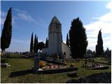
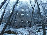
 | Komare doline - Sveti Kvirik
The church or chapel of St.Kvirik (on maps and elsewhere we can also find names such as St.Kirk, Kirik, Kvirk, Kvirin, Kirin) is located on the l...
1 h 20 min |
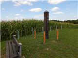 | Nuskova - Serdiški breg (Rdeči breg)
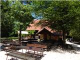
Serdiškis, or Red Bank, is a 416 m high hill located near the border with Austria. The grassy hill, with a few benches and a wooden log cabin, of...
50 min |
| Nuskova - Serdiški breg (Rdeči breg) (via Brunarjev breg)
Serdiškis, or Red Bank, is a 416 m high hill located near the border with Austria. The grassy hill, with a few benches and a wooden log cabin, of...
1 h |
| Serdica - Serdiški breg (Rdeči breg) (via Brunarjev breg)
Serdiškis, or Red Bank, is a 416 m high hill located near the border with Austria. The grassy hill, with a few benches and a wooden log cabin, of...
50 min |
 | Dolena (Stojana vas) - Janški vrh
Janški vrh is a 417m high peak on which stands a small village of the same name and the 15th century church of St John the Baptist. The place is ...
50 min |
| Naraplje - Janški vrh
Janški vrh is a 417m high peak on which stands a small village of the same name and the 15th century church of St John the Baptist. The place is ...
1 h 30 min |
 | Sotina - Sotinski breg (Kugla) (via the source of mineral water)
Sotinski breg or Kugla is the highest peak in Prekmurje at 418 m. From the top, which has a wooden lookout tower with a bell and a cross on it, y...
50 min |
 | Lokvica - Fajti hrib
Fajti, according to some records also Fajti hrib, is a 433 m high peak located in the ridge of the Black Hills. The summit, which is known mainly...
1 h |
 | Phliški bajer - Mengeška koča on Gobavica (ridge path)
Gobavica is a hill rising above Mengeš. There is a Mengeš hut on the hill, and they also have a goat stall. It is one of the starting points for ...
1 h 10 min |
 | Phliški bajer - Mengeška koča on Gobavica (lower path)
Gobavica is a hill rising above Mengeš. There is a Mengeš hut on the hill, and they also have a goat stall. It is one of the starting points for ...
1 h |
 | Laško (pokopališče Laško) - Cerkev sv. Mihaela na Šmihelu (mimo sv. Krištofa)
...
52 min |
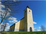
 | Vojnik - Sveti Tomaž above Vojnik
St.Thomas is a church standing on a partially vegetated 444 m high peak near Vojnik. On the top there is a registration book with a stamp. Below ...
1 h |
 | Ljubljana (Gruberjeva brv) - Mazovnik (Golovec)
At 450 m, Mazovnik is the highest peak of Golovec, a hill located in the south-eastern part of Ljubljana. Golovec was unforested until the end of...
1 h |
 | Ljubljana (Žabja vas) - Orle
Orle is a locality in the municipality of Lavrica, located on a small hill northeast of the Ljubljana Mor. A few metres below the highest point o...
1 h 15 min |
| Ljubljana (Sveti Urh) - Orle
Orle is a locality in the municipality of Lavrica, located on a small hill northeast of the Ljubljana Mor. A few metres below the highest point o...
1 h 10 min |
 | Suhadole - Koseški hrib (via Mlinčki)
Koseški hrib is located between Kuharjevi boršt' and Kosezami, the settlement after which the peak is named. From the top, where there is a table...
50 min |
| Bukovica pri Vodicah - Koseški hrib (via Mlinčki)
Koseški hrib is located between Kuharjevi boršt' and Kosezami, the settlement after which the peak is named. From the top, where there is a table...
50 min |
 | Topole - Koseški hrib
Koseški hrib is located between Kuharjevi boršt' and Kosezami, the settlement after which the peak is named. From the top, where there is a table...
55 min |
 | Okrepčevalnica Zelena dolina - Cerkev Marije Loretske na Ložnem
...
1 h 5 min |
| Brzika - Cerkev Marije Loretske na Ložnem
...
55 min |
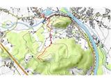
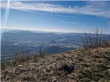
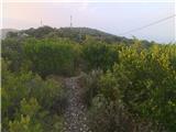
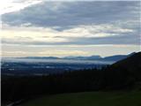
 | Komare doline - Kuk
Kuk (also Ščukovec on some maps) is a 498 m high hill located north of the village of Movraž. From the top, where a small cross stands, you can e...
1 h 15 min |
 | Zazid - Kuk
Kuk (also Ščukovec on some maps) is a 498 m high hill located north of the village of Movraž. From the top, where a small cross stands, you can e...
1 h |
 | Loka pri Žusmu (Žamerk) - Grad Žusem
...
50 min |
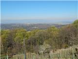
 | Šentilj v Slovenskih goricah - Plački vrh
Plački vrh is a peak in Slovenske Gorice. It lies in the municipality of Kungota, right on the border with Austria.It has a 28-metre-high lookout...
1 h |
 | Repnje - Smledniški hrib (Stari grad)
The Old Castle (also Smlednik Castle) is located on a small hill south-west of Valburg. A few years ago, the castle was rebuilt and the nearby tr...
1 h 15 min |
 | Dom Frata - Ostri vrh (above Globodol)
Ostri vrh is a 523 m high peak located between Vrbovec, Rdeči Kal, Gorenji, Sredni and Dolenji Globodol, Dolni and Gorni Ajdovec and Podlipa. The...
1 h 20 min |
| Rdeči Kal - Ostri vrh (above Globodol) (via Dom LD Dobrnič)
Ostri vrh is a 523 m high peak located between Vrbovec, Rdeči Kal, Gorenji, Sredni and Dolenji Globodol, Dolni and Gorni Ajdovec and Podlipa. The...
1 h |
 | Liboje - Kamčič (via organic farm Kralj - southern approach)
Kamčič is a vegetated peak in Posavsko hribovje, located north of Šmohor, between Kotečnik on the left and Veliki Slomnik on the right. It can be...
1 h 10 min |
 | Brezje pri Dobrovi - Vrh (Debeli hrib) (via Strmca)
The summit is a 540 m high hill located on the Debeli hrib ridge, a ridge situated between the Ljubljana Marshes and the Horjulščice River valley...
1 h 15 min |
 | Dragomer - Vrh (Debeli hrib) (on Pentlja)
The summit is a 540 m high hill located on the Debeli hrib ridge, a ridge situated between the Ljubljana Marshes and the Horjulščice River valley...
1 h |
 | Treskavac - Veli Vrh
Veli Vrh is not the highest peak on the island of Krk, but it offers the best view of the whole island, the Gulf of Reška / Gulf of Rijeka, Učki ...
50 min |
 | Bridge over Dušica - Zaplaz
Zaplaz is a 543-metre-high hill located above Čatež, a village known mainly for the destination of the Levstik Trail (From Litija to Čatež). On t...
1 h |
 | Wildon - Buchkogel (Wildoner Berg)
Buchkogel or Wildoner Berg is a 550 m high hill in the south of Styria, Austria. Together with the Wildoner Schlossberg (450 m) and the Bockberg ...
1 h 30 min |
 | ŽP Buzet - Pilj (nad Buzetom)
...
1 h |
 | Borovic (cesta na Hum) - Sveti Duh (Hum) (mimo Titove špilje)
...
50 min |
 | Založe (Hotunjščica) - Sevčnik (Andraška pot (pri Vodostečni))
Sevčnik is a hill located NE of Polzela on the Polzela - Velenje road. The larger settlement in its vicinity is called Andraž nad Polzela. The hi...
1 h 30 min |
 | Bad Gleichenberg (Eichgraben Weg) - Bschaidkogel (via Steinriegel)
...
1 h 30 min |
 | Treskavac - Obzova
Obzova is the highest point on the island of Krk. Like the surrounding area, the peak is completely rocky. Interesting are the puddles near the t...
1 h 30 min |
 | Špitalič pri Slovenskih Konjicah - Babček
Babček, an undistinguished peak on the mountain trail between Konjiška Gora and Boč. An asphalt road leads practically under the peak itself. The...
50 min |
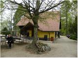
 | Šahovec - Trebni vrh (Baragova pot)
Trebni vrh is a 581-metre-high hill located south or south-west of Trebnje. On the top of the forested hill there is a bench, and near it there i...
1 h 5 min |
 | Velenje (Stari trg) - Veliko Gradišče
Gradišče is a hill above Pesje near Velenje. It has two peaks, Veliko and Malo Gradišče. Veliko Gradišče is located to the west of the Church of ...
1 h |
 | Zreče (Terme Zreče) - Sveti Martin (Zlakova) (on PP1)
St Martin's Church is situated on a lookout on the outskirts of Zlakova. From the church you can enjoy a beautiful view of the Pohorje, Brinjeva ...
55 min |