|
| Mrki12. 02. 2012 18:34:16 |
Bravo! I hope your ascent descriptions are followed by critics of Viševnik too.
| (+3) |  | |
|
|
|
|
| ljubitelj gora12. 02. 2012 20:27:09 |
I must first praise him for his feats with the younger mountaineers, keep going like that.
| (+2) | | |
|
|
|
|
| Flora11. 04. 2012 19:28:34 |
Mountains are a bit neglected due to projects, so the goal was something shorter - Storžič. I thought it would clear in the afternoon, but it was still completely fogged, so I turned to Bašelj Peak, which was also fully in clouds. Only when descending from Kališče did the view into the valley open.
Start at the first parking at Mače, but I see they drive higher up. Last time at Kališče around 2006, I see the path is super arranged and a polygon for local runners. It really is nice - cleaned, supported, fast up and down. It really surprised me. From Kališče onwards I met no one in that fog. Start 11.25, 13.30 at the summit, 14.45 back at the car. No pics, sorry, phone died, only photoworthy was sugar on blueberries towards B. pass, otherwise no views. Whole path dry.
|
|
|
|
| Andrej59. 07. 2012 22:04:05 |
Drove to Jezersko, turned left at Kanonir and then straight a few more kilometers to the barrier. From there continued on foot along the nice gravel road for another kilometer or two. Then turned left off-trail up the hill and reached the ridge between Turn and Licjanovec. There is supposed to be a path from the valley, but I couldn't find it. On the ridge, surprise, a new forest road has been built from the other side. Looks like they're going to log big time.
Continued along the ridge to Licjanovec. Got off the path twice, and once more bushwhacked through scrub. Otherwise, it's a nice little path routed sometimes along the edge of a precipice. From Licjanovec continued to M. Grintavec. From there to Bašelj Peak and down to Bašelj Saddle and back to the car along the marked trail.
No logbook or stamp at Bašelj Peak, and the pencil at M. Grintavec wasn't writing.
 1 1 2 2
|
|
|
|
| pantani119. 11. 2012 11:59:56 |
On Saturday we set off on the circular path to Kališče, to Bašelj Peak!!! Initially we planned the route via Mali Grintavec, but due to extreme fatigue we had to shorten it!!! Went towards Srednji vrh, the path was quite muddy at the beginning, but when we reached the forest path, conditions were completely different, pure pleasure walking through the forest where sun rays occasionally shone on us  !!! Just before the summit (at Kališče) the sun fully broke out , so we stopped in front of the hut, had a little snack, sprawled out and enjoyed !!! Just before the summit (at Kališče) the sun fully broke out , so we stopped in front of the hut, had a little snack, sprawled out and enjoyed  ! After loafing around, we headed to Bašelj Peak, where unfortunately it was blowing quite strongly and coldly, so we took a few photos and quickly headed back ! After loafing around, we headed to Bašelj Peak, where unfortunately it was blowing quite strongly and coldly, so we took a few photos and quickly headed back !!! It was a beautiful day !!! It was a beautiful day 
 1 1 2 2 3 3 4 4 5 5 6 6 7 7 8 8 9 9 10 10 11 11 12 12 13 13
| (+1) | | |
|
|
|
|
| PV8. 04. 2013 14:48:17 |
Promising weather forecast lured me to Bašelj Peak today. Unfortunately, the forecasters on all possible TVs and internet portals were way off (even on Hribi it's still sunny at Bašelj Peak  ), so no desired sunbathing with the brought beer, neither at Kališče nor at the summit. But for exercise it was quite... ), so no desired sunbathing with the brought beer, neither at Kališče nor at the summit. But for exercise it was quite... 
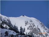
Start at Mače, snow starts about halfway to Kališče, even to the snow the path isn't too muddy, from the snow line onwards quickly into real winter. The path is of course well trodden, so to Kališče without issues just in boots, further on I put on my Veriga small "crampons", which were especially useful on the way back to the valley (highly recommend). From Kališče onwards only a few people went, no proper track made, but just enough footprints that in the fog like today give a good sense of the right path . There's still huge amounts of snow up there, but it's so hard that it even nicely carried my poor 100 kg without sinking.
Looks like winter in the mountains will be quite long still...
| (+9) | | |
|
|
|
|
| serajko9. 04. 2013 16:42:25 |
hi
A bit late but anyway. This is how @primoza and the kids looked mid-March on Bašelj Peak from Kališče.
 1 1
| (+3) | | |
|
|
|
|
| gmirko14. 12. 2013 15:16:21 |
Today wonderful. Visits also to Storžič.
| (+2) | | |
|
|
|
|
| Mrki2. 01. 2014 17:58:21 |
Today from Mače to Bašelj Peak. Path quite muddy, from Spodnje Kališče - former pasture - to the hut a bit icy, real winter from the hut onwards. Summit in thick fog with wind. Hut at Kališče was open today too. Warden friendly, no assistant.
| (+2) | | |
|
|
|
|
| Mrki27. 01. 2014 16:36:45 |
Forecasters predicted: "Today cloudy or foggy,..." So I said to myself: I can go to Kališče even in fog. But above 1000 m it was completely clear, blue sky, no wind and real winter idyll. Path nicely trodden, even to Bašelj Peak nice track. At the summit dry bench and warm sun and beautiful views all around. Over the weekend they trampled to Storžič too. Camera unfortunately stayed home.
Finally managed to upload some phone pics.
| (+6) | | |
|
|
|
|
| pantani128. 01. 2014 05:52:12 |
Mrki. I doubt anyone was on Storžič. We were on Mali Grintovec, and we were tempting fate (avalanche danger). Hope no one really went and played with their life like that. Safe steps Lp.
|
|
|
|
| mukica28. 01. 2014 06:36:04 |
Oh they were there, for sure, I know them...
| (+1) | | |
|
|
|
|
| pantani128. 01. 2014 07:01:31 |
Well, for me that's very irresponsible if they really were there, but that's just my opinion .
|
|
|
|
| sodnick28. 01. 2014 08:14:25 |
On Storžič, the winter variant goes along the ridge, not on the slope like the summer one, so it is less dangerous for avalanches than it seems if thinking about summer routes. But the traverse under the summit is dangerous. As far as I know, Storžič is more dangerous for slips. I also saw pics from the summit on Saturday. To me, that goal didn't seem suitable this weekend. Otherwise, each to their own.
| (+2) | | |
|
|
|
|
| pantani128. 01. 2014 08:52:51 |
I agree with you, but still, at any cost?!
|
|
|
|
| koksi28. 01. 2014 09:04:15 |
Here he is, even the yeti was chasing him.
 1 1 2 2
| (+1) | | |
|
|
|
|
| Mrki28. 01. 2014 09:05:33 |
I saw Storžič had visitors with my own eyes, not climbers but trail - track, both in scrub above Bašelj Saddle and on traverse under summit. On way to Kališče met warden who asked if going to top as quite a few were up there. Wind-slabs only in gully a bit above Bašelj Saddle.
| (+1) | | |
|
|
|
You must log in to post a comment:
If you do not yet have a username, you must first
register.