 | Mala voda - Kožljek
Kožljek is a 788 m high peak located to the west of Koreno, specifically above the village of Samotorica. From the top, where there are a few ben...
1 h 15 min |
 | Mala voda - Koreno
Koreno also Koreno is a 729 m high hill located north of Horjul. From the top, where there is a large cross, the Church of St. Mohorj and Fortuna...
1 h 15 min |
 | Grgar - Sveta Gora (by road)
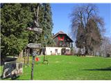
Sveta Gora is known mainly by the faithful and locals. Sveta Gora is a well-known pilgrimage centre above Nova Gorica. It is visited by believers...
1 h 15 min |
 | Grgar - Vodice (on the route of gas line)
Vodice (according to some records also Sv. Jakob) is a peak located in the western part of the Banjška plateau. The summit, on which the mausoleu...
1 h 30 min |
 | Grgar - Vodice (by road)
Vodice (according to some records also Sv. Jakob) is a peak located in the western part of the Banjška plateau. The summit, on which the mausoleu...
1 h 15 min |
 | Slavkov dom na Golem Brdu - Rog
The Rog is a 798 m high peak located above the village of Topole, just 10 minutes from St Catherine's Church. From the top of the hill, where a l...
1 h 40 min |
 | Preddvor - Štefanja gora (on footpath)
Štefanja gora on which the Church of St Stephen stands, is located above Cerkly in Gorenjska. Just 10 metres below the summit, the Pr'Mežnarju ex...
1 h 20 min |
 | Rakovnik - Sveti Florijan (Tehovec) (via Breznik)
The Church of St Florian is a branch church located in the village Tehovec above Medvode. The church, which was first mentioned in 1548, offers a...
1 h 20 min |
 | Puščava - Lobnikov vrh
Lobnikov vrh is a forested peak above the Drava Valley, situated between Fala and Ruta. From the east, it loks like a solitary rock due to its di...
1 h 20 min |
| Fala Grad - Lobnikov vrh
Lobnikov vrh is a forested peak above the Drava Valley, situated between Fala and Ruta. From the east, it loks like a solitary rock due to its di...
1 h 15 min |
 | Izlake (Medijske toplice) - Vrhija (via Podlipovica)
Vrhija is a 648 m high hill located west of Izlake and east of Kolovrat. It lies between Kalanov hrib and Kolovrat ribs, viewed from the N-S dire...
1 h 15 min |
 | Bottom station of Pohorje cable car - Pečke (via Meranovo)
Pečke is an easily accessible and recently less and less visited peak located north of the main ridge of Pohorje. It receives more visitors only ...
2 h |
 | Preddvor - Apnišče (on footpath)
Apnišče is a 740 m high mountain located between Možjanca and Štefanja gora. It is the highest point of the Šenčur municipality. There is a bench...
1 h 15 min |
 | Rudnik pri Radomljah - Tolsta gora
Tolsta gora is a 734-metre-high mountain located above Vrhpolje near Kamnik. From the top, where cairn stands, there is no better view, thanks to...
1 h 25 min |
| Pravdan - Tolsta gora (via Čeh)
Tolsta gora is a 734-metre-high mountain located above Vrhpolje near Kamnik. From the top, where cairn stands, there is no better view, thanks to...
1 h 45 min |
 | Rudnik pri Radomljah - Vrtače (via Lancar)
Vrtače is a 758-metre-high peak located above the village of Zgornje Palovče. The peak is covered with forest, but the clearing slightly below th...
1 h 30 min |
| Pravdan - Vrtače (via Zgornje Palovče)
Vrtače is a 758-metre-high peak located above the village of Zgornje Palovče. The peak is covered with forest, but the clearing slightly below th...
1 h 45 min |
 | Škofja Loka - Vrh soteske (Križna gora)
Vrh soteske is a 735 m high peak located in the south-western part of Križna Gora. There is no better view from the top, which is covered by fore...
1 h 25 min |
| Vešter - Vrh soteske (Križna gora)
Vrh soteske is a 735 m high peak located in the south-western part of Križna Gora. There is no better view from the top, which is covered by fore...
1 h 15 min |
 | Graz Center West - Buchkogel (Rudolfswarte) (via St. Martin)
Buchkogel, also called Graz Buchkogel, is located in the west of Graz and is one of the most popular excursion destinations on the outskirts of t...
1 h 30 min |
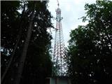
 | Hotavlje - Vrh Slajke
Vrh Slajke is a 790-metre-high hill located above Hotavlje, on the right bank of the Kopačnice River. From the top, where the antenna tower stand...
1 h 15 min |
| Hotavlje - Vrh Slajke (via Bela)
Vrh Slajke is a 790-metre-high hill located above Hotavlje, on the right bank of the Kopačnice River. From the top, where the antenna tower stand...
1 h 30 min |
| Podgora - Vrh Slajke
Vrh Slajke is a 790-metre-high hill located above Hotavlje, on the right bank of the Kopačnice River. From the top, where the antenna tower stand...
1 h 25 min |
 | Naraplje - Kerješetov vrh
Kerješetov vrh is a 590-metre-high hill located above Jelovice. The hill is covered with forest, and the view is second to none....
1 h 30 min |
 | Žetale - Joški vrh
Joški vrh is a 595-metre-high peak located on the northern side of Donacca Mountain. A short unmarked trail leads to the summit, which branches o...
2 h |
| Brzika - Joški vrh
Joški vrh is a 595-metre-high peak located on the northern side of Donacca Mountain. A short unmarked trail leads to the summit, which branches o...
1 h 15 min |
| Stoperce - Joški vrh
Joški vrh is a 595-metre-high peak located on the northern side of Donacca Mountain. A short unmarked trail leads to the summit, which branches o...
1 h 35 min |
 | Zreče (Terme Zreče) - Golek (steep path)
Golek is a 769-metre-high peak located north-west of Zreče. At the top there is a registration box with a registration book, a stamp and a bench,...
1 h 20 min |
 | Ruše - Globokarjev vrh
...
1 h 15 min |