 | Nuskova - Serdiški breg (Rdeči breg) (via Brunarjev breg)
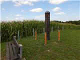
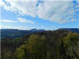
Serdiškis, or Red Bank, is a 416 m high hill located near the border with Austria. The grassy hill, with a few benches and a wooden log cabin, of...
1 h |
 | Naraplje - Janški vrh
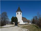
Janški vrh is a 417m high peak on which stands a small village of the same name and the 15th century church of St John the Baptist. The place is ...
1 h 30 min |
 | Otočec - Sveta Marija (Trška Gora) (via Stari grad)
Trška gora is one of Slovenia's most famous wine mountains, where the southern slope is home to the world's largest number of farmhouses and wher...
1 h 15 min |
| Otočec - Sveta Marija (Trška Gora)
Trška gora is one of Slovenia's most famous wine mountains, where the southern slope is home to the world's largest number of farmhouses and wher...
1 h |
 | Lokvica - Fajti hrib
Fajti, according to some records also Fajti hrib, is a 433 m high peak located in the ridge of the Black Hills. The summit, which is known mainly...
1 h |
 | Phliški bajer - Mengeška koča on Gobavica (ridge path)
Gobavica is a hill rising above Mengeš. There is a Mengeš hut on the hill, and they also have a goat stall. It is one of the starting points for ...
1 h 10 min |
 | Laško (pokopališče Laško) - Cerkev sv. Mihaela na Šmihelu (mimo sv. Krištofa)
...
52 min |
 | Ljubljana (Gruberjeva brv) - Mazovnik (Golovec)
At 450 m, Mazovnik is the highest peak of Golovec, a hill located in the south-eastern part of Ljubljana. Golovec was unforested until the end of...
1 h |
 | Ljubljana (Žabja vas) - Orle
Orle is a locality in the municipality of Lavrica, located on a small hill northeast of the Ljubljana Mor. A few metres below the highest point o...
1 h 15 min |
 | Lokvica - Veliki vrh (Črni hribi)
Veliki vrh is a 463 m high peak located in the ridge of the Black Hills. The summit, where the registration box is located, has no view due to th...
1 h 30 min |
 | Dragomer - Strmca (via Debeli hrib)
Strmca is a lesser-known and forested hill located between Brezje pri Dobrovi and Log pri Brezovici. There is no view from the top due to the for...
1 h 15 min |
 | Dragomer (bajer) - Vrhovčev grič (mimo Ferjanke in čez Strmco)
Vrhovčev grič is a nondescript and forested peak located only a few metres away from the marked path between Debeli hill and Strmca....
1 h 10 min |
 | Komare doline - Kuk
Kuk (also Ščukovec on some maps) is a 498 m high hill located north of the village of Movraž. From the top, where a small cross stands, you can e...
1 h 15 min |
 | Komare doline - Veliki Gradež
Veliki Gradež is a 507 m high hill located between Zazid and Movraz. From the top, set amidst vast pastures, you can enjoy a beautiful view of th...
1 h 30 min |
 | Šentilj v Slovenskih goricah - Plački vrh
Plački vrh is a peak in Slovenske Gorice. It lies in the municipality of Kungota, right on the border with Austria.It has a 28-metre-high lookout...
1 h |
 | Lovska koča Muljava - Mali Petrovac (Petrova gora) (Roman path)
Mali Petrovac is a rather low hill located somewhere on the border between Banja and Kordun, Pannonian Croatia and Gorski Kotar. The top is compl...
1 h |
 | Hunting cottage Muljava - Mali Petrovac (Petrova gora) (via Mali Velebit)
Mali Petrovac is a rather low hill located somewhere on the border between Banja and Kordun, Pannonian Croatia and Gorski Kotar. The top is compl...
1 h 15 min |
 | Gojače - Školj Svetega Pavla above Vrtovin (past trough)
The St Paul's Collegium is located on a lookout above the village of Vrtovin, west of Ajdovščina. From the church, near which the registration bo...
1 h |
| Malovše - Školj Svetega Pavla above Vrtovin
The St Paul's Collegium is located on a lookout above the village of Vrtovin, west of Ajdovščina. From the church, near which the registration bo...
1 h 5 min |
 | Rdeči Kal - Ostri vrh (above Globodol) (via Velika raven)
Ostri vrh is a 523 m high peak located between Vrbovec, Rdeči Kal, Gorenji, Sredni and Dolenji Globodol, Dolni and Gorni Ajdovec and Podlipa. The...
1 h 15 min |
| Rdeči Kal - Ostri vrh (above Globodol) (via Dom LD Dobrnič)
Ostri vrh is a 523 m high peak located between Vrbovec, Rdeči Kal, Gorenji, Sredni and Dolenji Globodol, Dolni and Gorni Ajdovec and Podlipa. The...
1 h |
 | Liboje - Kamčič (via organic farm Kralj - southern approach)
Kamčič is a vegetated peak in Posavsko hribovje, located north of Šmohor, between Kotečnik on the left and Veliki Slomnik on the right. It can be...
1 h 10 min |
 | Tremerje - Vipota
Vipota is a 532-metre-high peak south of Celje, above the left bank of the Savinja. Approaches to the summit are possible from several directions...
1 h |
 | Zagrad - Vipota
Vipota is a 532-metre-high peak south of Celje, above the left bank of the Savinja. Approaches to the summit are possible from several directions...
1 h |
 | Zagrad - Vipota (via crossing Ivankovič)
Vipota is a 532-metre-high peak south of Celje, above the left bank of the Savinja. Approaches to the summit are possible from several directions...
1 h 15 min |
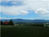
 | Zgornje Poljčane - Ljubična gora
Ljubična gora is a hill located above Ljubično, Zbelovo and Zbelovo Gora. The hill is hidden in the forest and is not very visible, but the churc...
1 h 15 min |
 | Velika Kostrevnica - Kožljevec
Kožljevec (also Kožlevec) is a 533 m high hill above Cerovica in the municipality of Šmartno pri Litija. The top, which also has a box with a reg...
1 h 10 min |
 | Naraplje - Church of St. Bolfenk (Jelovice)
The Church of St. Bolfenko is situated on a 537-metre-high hill above Jelovice. From the top, you can enjoy a beautiful view of the Haloze and Bo...
1 h |
| Stogovci (Vabča vas) - Church of St. Bolfenk (Jelovice)
The Church of St. Bolfenko is situated on a 537-metre-high hill above Jelovice. From the top, you can enjoy a beautiful view of the Haloze and Bo...
1 h |
 | Brezje pri Dobrovi - Vrh (Debeli hrib) (via Strmca)
The summit is a 540 m high hill located on the Debeli hrib ridge, a ridge situated between the Ljubljana Marshes and the Horjulščice River valley...
1 h 15 min |
 | Dragomer - Vrh (Debeli hrib) (on Pentlja)
The summit is a 540 m high hill located on the Debeli hrib ridge, a ridge situated between the Ljubljana Marshes and the Horjulščice River valley...
1 h |
 | Okrog (Lazar) - Zaplaz
Zaplaz is a 543-metre-high hill located above Čatež, a village known mainly for the destination of the Levstik Trail (From Litija to Čatež). On t...
1 h 10 min |
| Bridge over Dušica - Zaplaz
Zaplaz is a 543-metre-high hill located above Čatež, a village known mainly for the destination of the Levstik Trail (From Litija to Čatež). On t...
1 h |
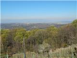
 | Wildon - Buchkogel (Wildoner Berg)
Buchkogel or Wildoner Berg is a 550 m high hill in the south of Styria, Austria. Together with the Wildoner Schlossberg (450 m) and the Bockberg ...
1 h 30 min |
 | Bad Gleichenberg (Eichgraben Weg) - Bschaidkogel (via Steinriegel)
...
1 h 30 min |
 | Zagorica pri Dobrniču - Lisec (Liška gora)
Lisec is a 565 m high peak located north to north-east of Žužemberk and south-west of Dobrnice. On the top of the peak stands a metal cross, to w...
1 h |
 | Treskavac - Obzova
Obzova is the highest point on the island of Krk. Like the surrounding area, the peak is completely rocky. Interesting are the puddles near the t...
1 h 30 min |
 | Trebnje Castle - Trebni vrh (steep path via hunting cottage)
Trebni vrh is a 581-metre-high hill located south or south-west of Trebnje. On the top of the forested hill there is a bench, and near it there i...
55 min |
| Trebnje Castle - Trebni vrh (via caves and hunting lodge)
Trebni vrh is a 581-metre-high hill located south or south-west of Trebnje. On the top of the forested hill there is a bench, and near it there i...
1 h |
 | Ljubljana (Podutik) - Toško Čelo
Toško Čelo is a 590 m high hill above the village of the same name. From the top, or slightly lower down, you have a beautiful view of part of Lj...
1 h |
 | Bad Gleichenberg (Eichgraben Weg) - Gleichenberger Kogel (via Mühlsteinbruch)
The Gleichenberger Kogel is a 598-metre-high volcanic mountain located above Bad Gleichenberg in Styria, Austria....
1 h 10 min |
| Bad Gleichenberg (Eichgraben Weg) - Gleichenberger Kogel
The Gleichenberger Kogel is a 598-metre-high volcanic mountain located above Bad Gleichenberg in Styria, Austria....
1 h 5 min |
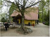
 | Griže - Dragov dom na Homu (direct path)
Drago's home is located on a scenic hill, south of Šempeter. From the top, which is also the Church of St. Magdalene, there is a beautiful view f...
1 h 30 min |
| Šešče pri Preboldu - Dragov dom na Homu (via Lajnarjev hrib)
Drago's home is located on a scenic hill, south of Šempeter. From the top, which is also the Church of St. Magdalene, there is a beautiful view f...
1 h |
| Šešče pri Preboldu - Dragov dom na Homu (Brdovska pot)
Drago's home is located on a scenic hill, south of Šempeter. From the top, which is also the Church of St. Magdalene, there is a beautiful view f...
1 h 15 min |
 | Bridge over Dušica - Bajturn (Zaplaški hrib) (on ridge)
At 609 metres, Bajturn or Zaplaz Hill is the highest peak in the municipality of Trebnje. At the top there is a nice bench with a table, a box wi...
1 h 20 min |
 | Haag - Stradner Kogel
Stradner Kogel is the highest hill in south-eastern Styria. The hill is of volcanic origin, and its vegetation prevents views in any direction. O...
1 h 10 min |