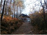
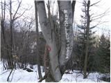
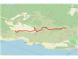
 | Gorica pri Slivnici - Žusem (Panoramska pot)
Žusem is a 669-metre-high hill with a colourful history and great potential for the future. It represents the northern edge of the Kozjansko regi...
3 h 20 min |
 | Štore - Resevna
Resevna is a peak located south of Šentjur. On the top is a 20m high lookout tower, which gives us a beautiful view of almost the whole of Sloven...
2 h 30 min |
 | Štore - Resevna (through Bojanski graben and over Resje nad Štorami)
Resevna is a peak located south of Šentjur. On the top is a 20m high lookout tower, which gives us a beautiful view of almost the whole of Sloven...
3 h 30 min |
 | Štore - Resevna (via Žlajfa and via Resje nad Štorami)
Resevna is a peak located south of Šentjur. On the top is a 20m high lookout tower, which gives us a beautiful view of almost the whole of Sloven...
3 h 15 min |
 | Rimske Toplice - Dom v Gorah (via Ogeški potok)
The mountain lodge in Gora is located east of Hrastnik, just a few metres below the 786m-high peak on which the Church of St George stands. From ...
2 h 40 min |
| Rimske Toplice (Šmarjeta) - Dom v Gorah (via Lurd)
The mountain lodge in Gora is located east of Hrastnik, just a few metres below the 786m-high peak on which the Church of St George stands. From ...
2 h 40 min |
 | Rimske Toplice - Vrhe (pri Gorah) (via Ogeški potok)
...
2 h 50 min |
| Rimske Toplice (Šmarjeta) - Vrhe (pri Gorah) (via Lurd)
...
2 h 50 min |
 | Litija - Janče (via Širmanski hrib)
Janče is a 792-metre-high peak located between the Sava River and the valley of the Besnica Stream. From the top, where the mountain lodge stands...
3 h 30 min |
 | Štore - Veliki vrh above Svetina (via Marija and over Svetina)
Veliki vrh is located south-west of Svetina above Štorá. It is inhabited mainly from the south and one of the homesteads is directly below the pe...
2 h 30 min |
 | Štore - Veliki vrh above Svetina (via Žlajfa and via Svetina)
Veliki vrh is located south-west of Svetina above Štorá. It is inhabited mainly from the south and one of the homesteads is directly below the pe...
2 h 15 min |
 | Štore - Veliki vrh above Svetina (through Bojanski graben and over Svetina)
Veliki vrh is located south-west of Svetina above Štorá. It is inhabited mainly from the south and one of the homesteads is directly below the pe...
2 h 30 min |
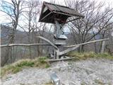 | Laško (pokopališče Laško) - Govško brdo
Govško brdo is an 811m high hill located west of the village of Huda jama above Laško. From the top of the hill, where the registration box and s...
2 h 35 min |
 | Zamedveje - Korada
Korada is a scenic peak located to the west of the Soča River and to the north or on the northern edge of Goriško Brda. From the summit, which ha...
2 h 30 min |
 | Kozje - Oslica (Bohor) (via Vetrnik)
Oslica is one of the peaks of Bohor. It is located in the eastern part of the mountain range. Unlike some of the higher peaks of Bohor, such as V...
2 h 10 min |
 | Izlake - Pleše (via Grobovščica)
Pleše is an 866 m high peak located between the Marela Ski Resort and Zasavska Sveta Gora. From the top, where the NOB monument is located, you h...
2 h 15 min |
 | Osilnica - Loška stena
Loška stena is located above the Upper Kolpa Valley, specifically above the villages of Grintovec pri Osilnici, Ložec and Ribjek. From the top of...
3 h 50 min |
 | HE Ožbalt - Klančnik (Glančnik)
Klančnik, also known as Glančnik on some maps, is an 877-metre-high peak located above the right bank of the Drava River, just a few minutes away...
2 h 10 min |
 | Podvelka - Klančnik (Glančnik) (via Sveti Ignacij)
Klančnik, also known as Glančnik on some maps, is an 877-metre-high peak located above the right bank of the Drava River, just a few minutes away...
2 h 30 min |
 | Hrastnik - Klobuk (via Ravne)
Klobuk is a scenic peak located northeast of Hrastnik. The summit, which has a registration box and a stamp, offers a beautiful view of the valle...
2 h 25 min |
 | Braslovško jezero - Grmada (Dobrovlje)
Grmada is an 898 m high forested peak located in the south-eastern part of the Dobrovlje plateau. The summit, on which the stamp is located, is n...
2 h 25 min |
 | HE Ožbalt - Hlebov vrh (Rdeči Breg)
The Red Bank stretches between the Radoljna Gorge in the east, the Drava River in the north and the Velka Stream in the east. It is separated fro...
2 h 50 min |
 | Jelovec - Žavcarjev vrh
Žavcarjev vrh is a 915m high mountain located north of the River Drava on the slopes of Kozjak. As the peak is completely overgrown, there is no ...
2 h 25 min |
 | Kozje - Debeli vrh (Bohor) (via Vetrnik)
Debeli vrh is a 921-metre-high peak on Bohor between Veliki Koprivnik and Oslice. It is overgrown with dense forest, so there are no views. There...
2 h 35 min |
 | Prebold - Reška planina
Reška planina is a peak in Posavsko hribovje, located southwest of Prebold. The marked trail does not lead to the summit, but to a nearby viewpoi...
3 h |
 | Spodnja Rečica - Malič (via Tolsto)
Malič is a 936 m high peak located between Celje and Laško, above Spodnja Rečica. There is no better view from the top, where the transmitter, be...
2 h 15 min |
| Laško - Malič
Malič is a 936 m high peak located between Celje and Laško, above Spodnja Rečica. There is no better view from the top, where the transmitter, be...
2 h 15 min |
| Železniška postaja Sevnica - Lisca (Iz Sevnice preko Zajčje Gore na Lisco)
Lisca is a scenic peak located north of Sevnica. From the top of the peak, where the meteorological radar station stands, there is a beautiful vi...
2 h 50 min |
 | Nakovana - Sveti Ilija (Pelješac)
Sv. Ilija, also known as Zmija's Bumblebee, is a 961-metre-high mountain and the highest peak on the Pelješac peninsula. From the top, you can en...
2 h 45 min |
 | Ožbalt - Sršenov vrh
Sršenov vrh is a 963-metre-high peak located in the Kozjak Mountains, specifically between Ožbalt and Zgornja Kapla. The peak itself does not off...
2 h 45 min |
 | Lesično - Koprivnik (Bohor)
Koprivnik or Veliki Koprivnik is one of the many peaks in Bohor. It is located between Koča na Bohorju and Veliki Koprivnik. From the top of the ...
3 h 15 min |
 | Kozje - Koprivnik (Bohor) (via Vetrnik)
Koprivnik or Veliki Koprivnik is one of the many peaks in Bohor. It is located between Koča na Bohorju and Veliki Koprivnik. From the top of the ...
3 h 10 min |
 | Hrastnik - Kal (via Klobuk)
Kal is a 985m high peak located between the more famous Mrzlica and the lesser known Klobuk. From the top where the bench stands, there is no bet...
2 h 25 min |
| Hrastnik - Kal (via Ravne)
Kal is a 985m high peak located between the more famous Mrzlica and the lesser known Klobuk. From the top where the bench stands, there is no bet...
2 h 25 min |
 | Zidani Most - Veliko Kozje
Veliko Kozje is a peak located west of Zidanega Most. From the summit, which has a registration box, there is a beautiful view of Zasavska and Po...
2 h 30 min |