 | Podgrad - Debenji vrh (via old castle Osterberg)
Debenji vrh, also Debni or Deben vrh, is the highest peak of Kašeljski Hill, a small mountain range located between the valley of Besnica and the...
50 min |
 | Ribnik - Debenji vrh
Debenji vrh, also Debni or Deben vrh, is the highest peak of Kašeljski Hill, a small mountain range located between the valley of Besnica and the...
40 min |
 | Dragomer - Vrh (Debeli hrib)
The summit is a 540 m high hill located on the Debeli hrib ridge, a ridge situated between the Ljubljana Marshes and the Horjulščice River valley...
40 min |
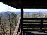
 | Vrzdenec - Gradišče nad Žažarjem (via Plesa)
Gradišče nad Žažarjem is a viewpoint with a large wooden cross. From the top, which also has a registration box with a stamp, you have a beautifu...
45 min |
 | Želimlje - Castle Stari grad above Želimlje
Castle Stari grad above Želimlje is a forested peak located between Želimlje and Rogatec above Želimlje....
50 min |
 | Podgrad - Španov vrh (Besnica)
Španov vrh is a 559-metre-high peak above the valley of the Besnica stream between Podgrad and Besnica. Just below the summit is the Borovnice hi...
50 min |
 | Bad Gleichenberg (Eichgraben Weg) - Bschaidkogel (via Mühlsteinbruch)
...
50 min |
 | Povodje - Veliki vrh (Rašica)
Veliki vrh is a 568 m high hill located to the west of Stanet Kosec Vrch. Just a few metres below the summit, which is covered with forest, is a ...
45 min |
 | Ruše - Lorbekov vrh
Lorbekov vrh is a 578-metre-high peak located south-west of Ruše. The peak is located in a forest, but the meadow just below the peak offers a be...
45 min |
 | Strmica - Toško Čelo (via Brezarjevo brezno)
Toško Čelo is a 590 m high hill above the village of the same name. From the top, or slightly lower down, you have a beautiful view of part of Lj...
45 min |
 | Šujica (Na Gmajni) - Toško Čelo
Toško Čelo is a 590 m high hill above the village of the same name. From the top, or slightly lower down, you have a beautiful view of part of Lj...
50 min |
 | Dobrova - Vrhe above Dobrova
Vrhe is a lesser-known but important peak in the extreme SE part of the Polhograje hills. It is reached by several unmarked tracks and trails lea...
50 min |
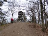
 | Podlipoglav - Pugled (past the guard post)
Pugled is a 615m high peak located between Podlipoglav and Veliki Lipoglav. The view from the top of the large NOB monument is limited due to the...
50 min |
 | Podlipoglav - Pugled (on the western ridge)
Pugled is a 615m high peak located between Podlipoglav and Veliki Lipoglav. The view from the top of the large NOB monument is limited due to the...
50 min |
 | Sveta Barbara (Nova Hrastnica) - Sveti Andrej (above Zminec)
The Church of St Andrew is located on a hill overloking the village of Sv. The church offers a beautiful view of Škofjeloško and Polhograjsko hri...
50 min |
 | Deutschfeistritz - Kugelberg
...
30 min |
 | Kranj (Kalvarija) - Šmarjetna gora (partly on footpath)
Šmarjetna gora is a scenic peak rising above Kranj. From the top, where the Church of St. Marjeta and the Belleuve Hotel stand, we have a beautif...
40 min |
| Kranj-Stražišče (Šrotenturn) - Šmarjetna gora (east path)
Šmarjetna gora is a scenic peak rising above Kranj. From the top, where the Church of St. Marjeta and the Belleuve Hotel stand, we have a beautif...
45 min |
 | Kranj-Stražišče (Šrotenturn) - Šmarjetna gora (west path)
Šmarjetna gora is a scenic peak rising above Kranj. From the top, where the Church of St. Marjeta and the Belleuve Hotel stand, we have a beautif...
40 min |
| Kranj-Stražišče (Šrotenturn) - Šmarjetna gora (by cart track)
Šmarjetna gora is a scenic peak rising above Kranj. From the top, where the Church of St. Marjeta and the Belleuve Hotel stand, we have a beautif...
45 min |
 | Tičnica - Šmarjetna gora
Šmarjetna gora is a scenic peak rising above Kranj. From the top, where the Church of St. Marjeta and the Belleuve Hotel stand, we have a beautif...
50 min |
 | Želimlje - Sv. Marjeta na Golem (najkrajša pot)
...
40 min |
 | Grad Hošperk - Stari grad
The Old Castle is a 703 m high peak located between Mountain pasture and Uncem. From the summit, where the transmitters are located, the forest a...
40 min |
 | Železniki - Hujska (via Kres)
Hujska is a 706-metre-high peak located above Železniki, more precisely between the Dašnjica and Češnjica streams. On the top there is a bench, a...
45 min |
| Železniki - Hujska
Hujska is a 706-metre-high peak located above Železniki, more precisely between the Dašnjica and Češnjica streams. On the top there is a bench, a...
40 min |
 | Zgornja Besnica (Nova vas) - Rovnik (west path)
Rovnik is a 707 m high peak located west of Zgornja Besnica. There is no better view from the top, where there are two benches, a wishing bell an...
40 min |
 | Zgornja Besnica (Nova vas) - Rovnik (east path)
Rovnik is a 707 m high peak located west of Zgornja Besnica. There is no better view from the top, where there are two benches, a wishing bell an...
45 min |
 | Sora - Hom (steep past cemetery)
Hom is a 715 m high peak rising steeply south-west of the village of Sora. The summit, which is partly covered with forest, offers a beautiful vi...
50 min |
 | Dobrič (Vedet) - Gora Oljka (by road)
Gora Oljka is a hill located east of Šmartno ob Paki. On the top stands the Church of the Holy Cross, which was built in the mid-18th century. Ju...
50 min |