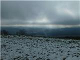
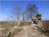
 | border crossing Sotina - Serdiški breg (Rdeči breg) (Austrian path)
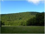
Serdiškis, or Red Bank, is a 416 m high hill located near the border with Austria. The grassy hill, with a few benches and a wooden log cabin, of...
45 min |
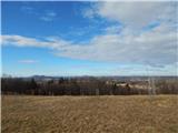
 | Sotina - Sotinski breg (Kugla) (via Patrov Breg)
Sotinski breg or Kugla is the highest peak in Prekmurje at 418 m. From the top, which has a wooden lookout tower with a bell and a cross on it, y...
30 min |
 | border crossing Sotina - Sotinski breg (Kugla) (western path)
Sotinski breg or Kugla is the highest peak in Prekmurje at 418 m. From the top, which has a wooden lookout tower with a bell and a cross on it, y...
30 min |
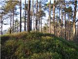
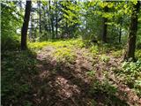
 | Komare doline - Krog
The Circle is a 418 m high hill located between Vrh križa and Kuk. From the top, which is lightly covered with trees, mainly pine, we have a view...
50 min |
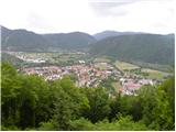 | Tolmin - Kozlov rob (Grajska pot)
Kozlov rob, or the Castle as the locals call it, is a 426-metre-high peak located above Tolmin. From the top, where the restored ruins of the for...
30 min |
 | Zagorica pri Dobrniču - Sveti Križ (Liška gora)
The Church of the Holy Cross is located to the east of the slightly higher and forested Lisec. From the church, near which there is a large meado...
40 min |
 | Ljubljana (Rakovnik) - Luknje
Luknje is a 438-metre-high peak in the north-western part of Golovec. On the top, where the Planetarium forest learning point is located, models ...
30 min |
 | Ljubljana (London) - Črni hrib (Golovec)
Črni hrib is a 440 m high hill located in the central part of Golovec. The so-called Path of Remembrance and Comradeship leads over the top, wher...
30 min |
 | Ljubljana (Rakovnik) - Črni hrib (Golovec)
Črni hrib is a 440 m high hill located in the central part of Golovec. The so-called Path of Remembrance and Comradeship leads over the top, wher...
50 min |
 | Ljubljana (Gruberjeva brv) - Črni hrib (Golovec)
Črni hrib is a 440 m high hill located in the central part of Golovec. The so-called Path of Remembrance and Comradeship leads over the top, wher...
50 min |
| Ljubljana (Štepanja vas) - Črni hrib (Golovec)
Črni hrib is a 440 m high hill located in the central part of Golovec. The so-called Path of Remembrance and Comradeship leads over the top, wher...
50 min |
 | Ljubljana (Bokalce) - Klobuk pri Ljubljani
Klobuk is a 441-metre-high peak located to the west of Ljubljana, specifically above Stranska vas near Dobrova. From the top, you can enjoy a bea...
30 min |
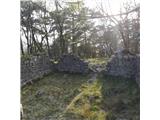
 | Podgrad - Castle Stari grad (Stari Osterberg) (on cart track)
Castle Stari grad or Old Osterberg was first mentioned in the 12th century (less probably as early as 1015), at which time the castle belonged to...
30 min |
 | Podgrad - Castle Stari grad (Stari Osterberg) (via millstone quarry)
Castle Stari grad or Old Osterberg was first mentioned in the 12th century (less probably as early as 1015), at which time the castle belonged to...
45 min |
 | Podgrad - Murjevka
Murjevka is a 443-metre-high peak above the valley of the Besnica stream, south of Podhrad. The peak is located in a forest so it does not offer ...
40 min |
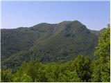
 | Vojnik - Sveti Tomaž above Vojnik (direct way)
St.Thomas is a church standing on a partially vegetated 444 m high peak near Vojnik. On the top there is a registration book with a stamp. Below ...
30 min |
 | Dragomer (bajer) - Strmec (above Dragomer) (mimo Ferjanke)
Strmec is a distinct and forested peak located between Dragomer and Log. A number of logging trail leads to the summit. It is located to the sout...
30 min |
 | Dragomer (OŠ Log-Dragomer) - Strmec (above Dragomer)
Strmec is a distinct and forested peak located between Dragomer and Log. A number of logging trail leads to the summit. It is located to the sout...
30 min |
 | Ljubljana (London) - Mazovnik (Golovec)
At 450 m, Mazovnik is the highest peak of Golovec, a hill located in the south-eastern part of Ljubljana. Golovec was unforested until the end of...
35 min |
 | Podgrad - Lazarjev vrh
Lazarjev vrh is a 452-metre-high peak above the confluence of the Sava, Ljubljanica and Kamniška Bistrica rivers, east of Podgrad. The summit, wh...
50 min |
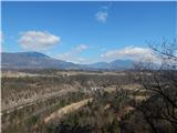
 | Preval Poljance - Mengore (steep path)
Mengore (453 m) rise between Most na Soči, Volče and Tolmin. From the top, where the Church of St. Mary and the St. Joseph's Shelter stand, you c...
30 min |
 | Suhadole - Koseški hrib (by cart track)
Koseški hrib is located between Kuharjevi boršt' and Kosezami, the settlement after which the peak is named. From the top, where there is a table...
40 min |
 | Sveti Lovrenc nad Dragomerom - Strmca (čez Vrhovčev grič)
Strmca is a lesser-known and forested hill located between Brezje pri Dobrovi and Log pri Brezovici. There is no view from the top due to the for...
50 min |
 | Stoperce - Škrbatnica
...
50 min |
 | Church of St. Lovrenc above Dragomer - Vrhovčev grič
Vrhovčev grič is a nondescript and forested peak located only a few metres away from the marked path between Debeli hill and Strmca....
30 min |
 | Brezje pri Dobrovi - Vrhovčev grič (via Strmca)
Vrhovčev grič is a nondescript and forested peak located only a few metres away from the marked path between Debeli hill and Strmca....
45 min |
 | Ruše - Kluže
...
45 min |
 | Lake Gradišče - Sveti Mohor on Mohorjev hrib
The Church of St. Mohor is situated on a lookout, on the lower top of Mohorje Hill above Moravče. From the top, you can enjoy a beautiful view of...
50 min |
 | Sveti Mihovil (nad Komižo) - Mali Hum
...
50 min |
 | Globoko - Ojstra peč (via Zjavka)
Ojstra peč is a scenic rocky pier between the Lipnik valley and the Sava valley at Globoke, descending precipitously towards the fields above the...
40 min |
 | Hraše - Smledniški hrib (Stari grad)
The Old Castle (also Smlednik Castle) is located on a small hill south-west of Valburg. A few years ago, the castle was rebuilt and the nearby tr...
45 min |
 | Temnica - Sveti Ambrož (Tabor) (western path)
Sveti Ambrož or Tabor is an peak in the Karst, located above the villages of Temnica and Lipa. On the top of the hill are the remains of the form...
45 min |
| Temnica - Sveti Ambrož (Tabor) (northern path)
Sveti Ambrož or Tabor is an peak in the Karst, located above the villages of Temnica and Lipa. On the top of the hill are the remains of the form...
50 min |
 | Dragomer - Vrh (Debeli hrib)
The summit is a 540 m high hill located on the Debeli hrib ridge, a ridge situated between the Ljubljana Marshes and the Horjulščice River valley...
40 min |
 | Church of St. Lovrenc above Dragomer - Vrh (Debeli hrib) (via Vrhovčev grič)
The summit is a 540 m high hill located on the Debeli hrib ridge, a ridge situated between the Ljubljana Marshes and the Horjulščice River valley...
45 min |
 | Vrzdenec - Gradišče nad Žažarjem (via Plesa)
Gradišče nad Žažarjem is a viewpoint with a large wooden cross. From the top, which also has a registration box with a stamp, you have a beautifu...
45 min |
 | Želimlje - Castle Stari grad above Želimlje
Castle Stari grad above Želimlje is a forested peak located between Želimlje and Rogatec above Želimlje....
50 min |
 | Bad Gleichenberg (Eichgraben Weg) - Bschaidkogel (via Mühlsteinbruch)
...
50 min |
 | Strmica - Toško Čelo (via Brezarjevo brezno)
Toško Čelo is a 590 m high hill above the village of the same name. From the top, or slightly lower down, you have a beautiful view of part of Lj...
45 min |
 | Vilenica - Stari tabor (mimo Tuple jame)
Stari tabor is a scenic peak located west of Divača, north of Lokev and south of the village of Povir. From the summit, where the stamp and the r...
50 min |
 | Sveta Barbara (Nova Hrastnica) - Sveti Andrej (above Zminec)
The Church of St Andrew is located on a hill overloking the village of Sv. The church offers a beautiful view of Škofjeloško and Polhograjsko hri...
50 min |