 | Rudno polje - Viševnik (via Kačji rob)
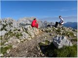
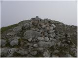
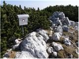
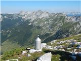
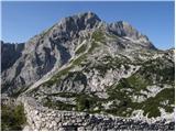
Viševnik is a 2050 m high mountain rising north-west of Rudno polje on Pokljuka. From the top of the peak where the stamp is located, you have a ...
2 h 20 min |
| End of road on Pokljuka - Viševnik (via Srenjski preval)
Viševnik is a 2050 m high mountain rising north-west of Rudno polje on Pokljuka. From the top of the peak where the stamp is located, you have a ...
2 h 20 min |
 | Planina Zajavornik - Viševnik
Viševnik is a 2050 m high mountain rising north-west of Rudno polje on Pokljuka. From the top of the peak where the stamp is located, you have a ...
3 h 30 min |
| Medvedova konta - Viševnik
Viševnik is a 2050 m high mountain rising north-west of Rudno polje on Pokljuka. From the top of the peak where the stamp is located, you have a ...
3 h 15 min |
| Pri Rupah - Viševnik
Viševnik is a 2050 m high mountain rising north-west of Rudno polje on Pokljuka. From the top of the peak where the stamp is located, you have a ...
3 h 15 min |
| Rudno polje - Viševnik (via Jezerce and Srenjski preval)
Viševnik is a 2050 m high mountain rising north-west of Rudno polje on Pokljuka. From the top of the peak where the stamp is located, you have a ...
2 h 40 min |
 | Uskovnica (Razpotje) - Viševnik (via Srenjski preval)
Viševnik is a 2050 m high mountain rising north-west of Rudno polje on Pokljuka. From the top of the peak where the stamp is located, you have a ...
2 h 55 min |
 | Planina pod Golico - Kahlkogel/Golica (winter way)
Kahlkogel is an unvegetated peak located north of Jesenice. From the top, which has a registration box, there is a beautiful view of the western ...
2 h 10 min |
| Planina Jezerca - Mokrica (via Košutna)
Mokrica is a scenic peak to the east of Kompotele. On the top, which is partly covered with dwarf pines, there is a registration book....
3 h |
 | Globoka dolina - Kofce gora
Kofce gora is a 1967 m high peak located in the eastern part of the longest Slovenian ridge. The peak, which descends precipitously towards Austr...
2 h 15 min |
 | Dol - Stegovnik (via Močnikovo sedlo)
Stegovnik (also Štegovnik) is a scenic ridge mountain between the valley of the Tržiška Bistrica and the Kokra. From the top there is a very nice...
2 h 30 min |
| Rezman - Stegovnik
Stegovnik (also Štegovnik) is a scenic ridge mountain between the valley of the Tržiška Bistrica and the Kokra. From the top there is a very nice...
2 h 15 min |
 | Planina Jezerca - Košutna (via planina Košutna)
The summit is located between Kompotela and mountain pasture Košutno. From the top there is a beautiful view towards Krvavec and the Kalški grebe...
2 h 20 min |
 | Mrzli studenec - Malo Kladivo
Malo Kladivo is located in the Košuta Ridge. From the summit, which has no registration box, there is a beautiful view of the neighbouring Veliko...
2 h |
 | Johannsenruhe - Bielschitza/Svačica
Bielschitza is a less prominent peak in the main ridge of the Karavanke. It is located between Vertatscha and Stol and is slightly offset to the ...
2 h 30 min |
| Bodenbauer - Bielschitza/Svačica (via Karweg)
Bielschitza is a less prominent peak in the main ridge of the Karavanke. It is located between Vertatscha and Stol and is slightly offset to the ...
3 h |
 | Planina Kuk - Žabiški Kuk (path past Gradič (old military path))
Žabiški Kuk is located on the southern side ridge of the Lower Bohinj Mountains near the better known Vogel and above mountain pasture Razor. Fro...
2 h 20 min |
 | Planina Kuk - Vrh nad Škrbino (direct way)
Vrh nad Škrbino is the easternmost two-thousandth peak in the ridge of the Lower Bohinj Mountains. From the top there is a very nice view of the ...
3 h 15 min |
 | Cave del Predil - Kraljevska špica/Monte Re
Kraljevska špica, or Monte Re in Italian, is a 1912 m high mountain located north-west of Rablja/Cave del Predil. From the top of the mine, where...
2 h 30 min |
 | Remšendol - Šober / Monte Sciober Grande (via 518)
Šober is a 1845 m high peak located between Remšendol and the Jezersko Valley. From the top you can enjoy a beautiful view of the nearby Rabeljsk...
3 h |
 | Rio Bianco - Škraplja
Škraplja is a 1794 m high peak located between Jerebica and Kanin. The summit, which is a famous battlefield of the First World War (many remnant...
2 h 30 min |
 | Cristo di Forca - Amariana
Amariana is a beautiful pyramidal mountain rising above the Tolmezzo, its exposed position affording spectacular views of the surrounding mountai...
2 h 30 min |
 | Vranček - Lokovnikov Grintovec / Grintoutz
Lokovnikov Grintovec is the dwarf pines vegetated peak to the north of Loibler Baba, from which it is separated by Dovjakovo sedlo (1728 m). Its ...
2 h 50 min |
 | Bodental - Rjautza
Rjautza (Rjavica on maps) is a 1789 m high peak located to the north of the main chain of the Karawanks border ridge. The summit, on which stands...
2 h 30 min |
 | Hintergupf - Matzen
Matzen is a 1,627-metre-high peak located north of Košuta and south of the River Drava. Macna offers a beautiful view of the nearby Obir, Košuta,...
2 h 30 min |