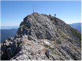
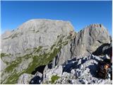
 | Koschutahaus - Koschutnikturm (Košutnikov turn) (ÖTK Steig Neu)
Košutna Turn is the highest peak in Slovenia's longest ridge, the Košuta. From the top, you have a beautiful view of the entire ridge. Austria an...
2 h 45 min |
 | Parking place below Nassfeld - Monte Cavallo / Rosskofel (by east ridge)
The Horse Spike / Monte Cavallo di Pontebba / Rosskofel is a 2240 m high and very scenic mountain in the Carnic Alps main ridge in the Wetlands /...
3 h 30 min |
 | Planina Kuk - Vrh nad Škrbino (via Škrbina)
Vrh nad Škrbino is the easternmost two-thousandth peak in the ridge of the Lower Bohinj Mountains. From the top there is a very nice view of the ...
3 h 45 min |
 | Ski hotel Vogel - Vrh nad Škrbino (po Bohinjski planinski poti)
Vrh nad Škrbino is the easternmost two-thousandth peak in the ridge of the Lower Bohinj Mountains. From the top there is a very nice view of the ...
4 h 30 min |
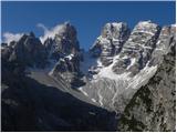
 | Rifugio Bai de Dones - Averau (via Rifugio Cinque Torri)
Averau is a 2649m high peak located between two Alpine passes, the "Passo di Giau" and the "Passo Falzarego" (south-west of Cortina d'Ampezzo). F...
2 h 45 min |
| Rifugio Bai de Dones - Averau (Trincee)
Averau is a 2649m high peak located between two Alpine passes, the "Passo di Giau" and the "Passo Falzarego" (south-west of Cortina d'Ampezzo). F...
3 h |
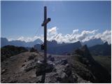
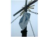
 | Jakobe - Feistritzer Spitze (climbing way)
Feistritzer Spitze is a 2113 m high peak located on the Austrian side of Pec. From the top on which the cross stands, you have a beautiful view o...
3 h 45 min |
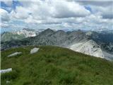
 | Jakobe - Končnikov vrh (climbing way)
Končnikov vrh is a 2109 m high mountain located in the central part of Pec. The grassy peak offers a beautiful view along the Pec ridge and the m...
2 h 45 min |
 | Plockenpass - Creta di Collinetta / Cellon (Via ferrata Steinberger Weg)
Creta di Collinetta/Cellon is a 2238 m high mountain located west of the Plockenpass. From the top with a cross, you have a beautiful view of the...
3 h |
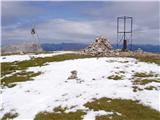
 | Rifugio Sorgenti del Piave - Monte Chiadenis (CAI di Portogruaro)
Monte Chiadenis is a 2459 m high mountain located between Monte Peralba and the summit of Crete Cacciatori. From the summit, which has a sign-in ...
2 h 30 min |
 | Koča Porze - Porze / Cima Palombino
Porze is a 2599 m high mountain in the border/main ridge Carnic Alps, above the upper reaches of the Zilja River. The rocky peak structure above ...
2 h 30 min |
 | Koča Porze - Porze / Cima Palombino (via notch Porze (Austrian secured path))
Porze is a 2599 m high mountain in the border/main ridge Carnic Alps, above the upper reaches of the Zilja River. The rocky peak structure above ...
2 h 30 min |
 | Carbonin - Monte Fumo / Rauhkofel (Northern route)
Monte Fumo is a 2114-metre-high mountain in the Cristallo mountain group. The summit, which is located in close proximity to the highest peaks of...
2 h 30 min |
| Carbonin - Monte Fumo / Rauhkofel
Monte Fumo is a 2114-metre-high mountain in the Cristallo mountain group. The summit, which is located in close proximity to the highest peaks of...
2 h 45 min |
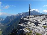 | Landro - Monte Piano (Via Ferrata Bilgeri)
Monte Piano (Toblacher Kreuz) is a 2305-metre-high mountain located on the north-western edge of the Monte Piana plateau. Near the summit there a...
3 h |