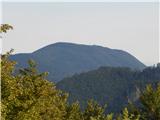
 | Vače - Zasavska Sveta gora
Zasavska Sveta gora is a popular excursion point located between Litija and Izlaki. From the top, where the parish church of the Nativity of the ...
2 h |
 | Zaplana (Prezid) - Ulovka
Ulovka is the peak between Zaplana and the Shelter at Mountain pasture above Vrhnika. From the top, which is reached by ski lifts, there is a nic...
1 h 45 min |
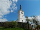
 | Visoko (Mali Kurešček) - Sveti Lenart (Krvava Peč)
The Church of Saint Lenart is situated on a small hill above the village Krvava Peč and the valley of the Ischka River. From the top or the nearb...
2 h 15 min |
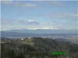
 | Predmeja - Navrše (Pot po Robu)
Navrše is a little-known peak located southeast of the Otliška Window. From the top there is a beautiful view of the Vipava valley and the peaks ...
2 h 15 min |
 | Predmeja - Otliški maj (Pot po Robu)
Otliški maj is a scenic peak located south of Otlica. From the top there is a beautiful view towards the Vipava valley, the slopes of Čavna, Gola...
1 h 45 min |
 | Velike Lašče - Kamen vrh (čez Gornje Retje in Grmado)
Kamen vrh is a scenic peak located on the northern outskirts of Mala Gora. From the top, surrounded by low bushes, there is a beautiful view of p...
2 h 35 min |
 | Velike Lašče - Grmada on Mala gora (čez Gornje Retje)
Grmada (also Grmada nad Ortnek) is an 887 m high peak located above the village of Vrh pri Poljanah in the Mala Gora mountain range. Just a few m...
2 h |
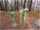
 | Mašon (Severjevo znamenje) - Murovica (circular path)
Murovica is a popular excursion point, accessible from the Posavina side, Domžale or from the Moravška valley. There is a bench and a registratio...
2 h 20 min |
 | Ledinsko Razpotje - Medvedje Brdo (east path)
Medvedje Brdo is a small settlement located north of Hotedršice. The highest point of the village is a pleasant lookout point located on Šinkovco...
3 h 10 min |
| Ledinsko Razpotje - Medvedje Brdo (west path)
Medvedje Brdo is a small settlement located north of Hotedršice. The highest point of the village is a pleasant lookout point located on Šinkovco...
3 h 15 min |
 | Zavrh pri Trojanah - Golčaj
Golčaj is a 690 m high hill rising south of Blagovica. On the top, which has a registration box and a stamp, stands the NOB monument, and a few 1...
2 h 30 min |
 | Mislinja - Fričev vrh (via Završe)
Fričev vrh is an 881 m high hill located south of Mislinja Dobrava. There is no view from the top, which has a registration box with a registrati...
2 h |
 | Šembije - Ahac
Ahac or St. Ahac is a 799 m high peak located east of Ilirska Bistrica. The summit, which is home to a registration box, a cross and the ruins of...
2 h |
 | Planina pri Sevnici - Brest (Bohor) (northern path)
Brest is a peak on Bohor although it loks more like a saddle. It is an important intersection of the Bohor trails. It lies between Oslica, which ...
2 h 20 min |
 | Sveta Katarina (Zgornja Kapla) - Sveti Pankracij (Radelca) (avstrijska pot)
The Church of St Pancras on Radelca is located on the border ridge between Slovenia and Austria, but since 1966, following an inter-state agreeme...
2 h 45 min |
 | Sveta Katarina (Zgornja Kapla) - Sveti Jurij (Remšnik)
The Church of St George is situated on a lookout point in the settlement Remšnik, which is on the slopes of Kozjak. Opposite the church, next to ...
2 h 50 min |