 | Kisovec - Castle Gamberk
...
1 h 10 min |
| Zagorje ob Savi - Castle Gamberk
...
1 h 35 min |
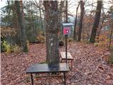
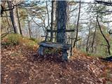 | Celje (hanging bridge) - Hom above Celje
Hom is a forested peak located north of Košnica near Celje. There is a small bench on top of the summit next to the registration box....
1 h |
 | Celje (hanging bridge) - Hom above Celje (via Petriček and Lisce)
Hom is a forested peak located north of Košnica near Celje. There is a small bench on top of the summit next to the registration box....
1 h 10 min |
 | Naraplje - Kerješetov vrh
Kerješetov vrh is a 590-metre-high hill located above Jelovice. The hill is covered with forest, and the view is second to none....
1 h 30 min |
 | Stoperce - Joški vrh
Joški vrh is a 595-metre-high peak located on the northern side of Donacca Mountain. A short unmarked trail leads to the summit, which branches o...
1 h 35 min |
| Prelaz Vrhe - Joški vrh
Joški vrh is a 595-metre-high peak located on the northern side of Donacca Mountain. A short unmarked trail leads to the summit, which branches o...
1 h 5 min |
| Sveti Jurij - Joški vrh
Joški vrh is a 595-metre-high peak located on the northern side of Donacca Mountain. A short unmarked trail leads to the summit, which branches o...
1 h 5 min |
 | Hruševo - Vrhe above Dobrova
Vrhe is a lesser-known but important peak in the extreme SE part of the Polhograje hills. It is reached by several unmarked tracks and trails lea...
1 h |
 | Ožbalt (dam on stream Črmenica) - Turška peč (on cart track)
...
1 h |
 | Ruše - Globokarjev vrh
...
1 h 15 min |
 | Zagorje ob Savi - Vinski vrh
...
1 h |
 | Olimje - Lendrše
...
1 h 20 min |
 | Olimje - Olimska gora (past lake Zmajevo jezero)
...
1 h 25 min |
 | Sora - Breznik (Boben)
Breznik, aka Boben, is a 643-metre-high peak located above the right bank of the Ločnica River, specifically above the Sora, Rakovnik, Goričane a...
1 h 5 min |
 | Izlake (Medijske toplice) - Vrhija (via Podlipovica)
Vrhija is a 648 m high hill located west of Izlake and east of Kolovrat. It lies between Kalanov hrib and Kolovrat ribs, viewed from the N-S dire...
1 h 15 min |
 | Grgar - Vodice (on the route of gas line)
Vodice (according to some records also Sv. Jakob) is a peak located in the western part of the Banjška plateau. The summit, on which the mausoleu...
1 h 30 min |
 | Grgar - Vodice (by road)
Vodice (according to some records also Sv. Jakob) is a peak located in the western part of the Banjška plateau. The summit, on which the mausoleu...
1 h 15 min |
 | Stari Grad (Šega) - Dedni vrh (Šuštarica)
Dedni vrh, also called Šuštarica, is a lesser known peak in Karawanks, located north of Plešivec. The peak is located in the forest and in the su...
1 h |
 | Graz Center West - Buchkogel (Rudolfswarte) (via St. Martin)
Buchkogel, also called Graz Buchkogel, is located in the west of Graz and is one of the most popular excursion destinations on the outskirts of t...
1 h 30 min |
 | Kamnik - Visoka špica (via Krniška gora)
An inconspicuous, but visible from everywhere, forested peak above Kamnik. It is more or less inconspicuous because of the slightly lower Čokl, o...
1 h |
 | Grgar - Sveta Gora (by road)
Sveta Gora is known mainly by the faithful and locals. Sveta Gora is a well-known pilgrimage centre above Nova Gorica. It is visited by believers...
1 h 15 min |
 | Puščava - Lobnikov vrh
Lobnikov vrh is a forested peak above the Drava Valley, situated between Fala and Ruta. From the east, it loks like a solitary rock due to its di...
1 h 20 min |
| Činžat - Lobnikov vrh
Lobnikov vrh is a forested peak above the Drava Valley, situated between Fala and Ruta. From the east, it loks like a solitary rock due to its di...
1 h |
| Fala Grad - Lobnikov vrh
Lobnikov vrh is a forested peak above the Drava Valley, situated between Fala and Ruta. From the east, it loks like a solitary rock due to its di...
1 h 15 min |
 | Dvor - Kucelj above Polhov Gradec (on marked path)
Kucelj is a lesser-known peak located between Polhov Gradec and Dvůr pri Polhovem Gradcu. From the 705-metre-high peak, there are views towards G...
1 h |
| Dvor - Kucelj above Polhov Gradec (on unmarked path)
Kucelj is a lesser-known peak located between Polhov Gradec and Dvůr pri Polhovem Gradcu. From the 705-metre-high peak, there are views towards G...
1 h |
| Polhov Gradec - Kucelj above Polhov Gradec (via Ravnek)
Kucelj is a lesser-known peak located between Polhov Gradec and Dvůr pri Polhovem Gradcu. From the 705-metre-high peak, there are views towards G...
1 h |
 | Briše - Mali vrh
To the west of Polhov Gradec, between the rivers Mala voda and Velika Božna, is a 708-metre-high hill called Mali vrh. From the grassy summit, wh...
1 h 5 min |
 | Log - Pečke (by road)
Pečke is an easily accessible and recently less and less visited peak located north of the main ridge of Pohorje. It receives more visitors only ...
1 h 5 min |
 | Prevalje - Brinjeva gora (above Prevalje) (via Stations of the Cross)
Brinjeva gora is a popular excursion spot for Prevalj inhabitants, located between the Meža River and the Zelenbreški brok. At the top of the hil...
1 h |
| Prevalje - Brinjeva gora (above Prevalje) (south path)
Brinjeva gora is a popular excursion spot for Prevalj inhabitants, located between the Meža River and the Zelenbreški brok. At the top of the hil...
1 h |
| Ravne na Koroškem - Brinjeva gora (above Prevalje)
Brinjeva gora is a popular excursion spot for Prevalj inhabitants, located between the Meža River and the Zelenbreški brok. At the top of the hil...
1 h 10 min |
 | Mala voda - Koreno
Koreno also Koreno is a 729 m high hill located north of Horjul. From the top, where there is a large cross, the Church of St. Mohorj and Fortuna...
1 h 15 min |
 | Rudnik pri Radomljah - Tolsta gora
Tolsta gora is a 734-metre-high mountain located above Vrhpolje near Kamnik. From the top, where cairn stands, there is no better view, thanks to...
1 h 25 min |
 | Škofja Loka - Vrh soteske (Križna gora)
Vrh soteske is a 735 m high peak located in the south-western part of Križna Gora. There is no better view from the top, which is covered by fore...
1 h 25 min |
| Vešter - Vrh soteske (Križna gora)
Vrh soteske is a 735 m high peak located in the south-western part of Križna Gora. There is no better view from the top, which is covered by fore...
1 h 15 min |
 | Adergas - Apnišče (via Šterna)
Apnišče is a 740 m high mountain located between Možjanca and Štefanja gora. It is the highest point of the Šenčur municipality. There is a bench...
1 h |
 | Rudnik pri Radomljah - Vrtače (via Lancar)
Vrtače is a 758-metre-high peak located above the village of Zgornje Palovče. The peak is covered with forest, but the clearing slightly below th...
1 h 30 min |
 | Zreče (Terme Zreče) - Golek (steep path)
Golek is a 769-metre-high peak located north-west of Zreče. At the top there is a registration box with a registration book, a stamp and a bench,...
1 h 20 min |
 | Liboje (quarry) - Kotečnik (via eastern ridge)
Kotečnik is a peak in Posavsko hribovje, located north of Šmohor. Kotečnik is a peak with two entry boxes. The first one is located on the wester...
1 h 5 min |
 | Selca - Lepo brdo
Lepo brdo is a 778-metre-high hill located above the settlements of Selca and Studeno....
1 h |
 | Deutschfeistritz - Parmaseggkogel (via Kugelberg)
...
1 h 15 min |
 | Mala voda - Kožljek
Kožljek is a 788 m high peak located to the west of Koreno, specifically above the village of Samotorica. From the top, where there are a few ben...
1 h 15 min |
 | Hotavlje - Vrh Slajke
Vrh Slajke is a 790-metre-high hill located above Hotavlje, on the right bank of the Kopačnice River. From the top, where the antenna tower stand...
1 h 15 min |
| Hotavlje - Vrh Slajke (via Bela)
Vrh Slajke is a 790-metre-high hill located above Hotavlje, on the right bank of the Kopačnice River. From the top, where the antenna tower stand...
1 h 30 min |
| Podgora - Vrh Slajke
Vrh Slajke is a 790-metre-high hill located above Hotavlje, on the right bank of the Kopačnice River. From the top, where the antenna tower stand...
1 h 25 min |
 | Slavkov dom na Golem Brdu - Rog
The Rog is a 798 m high peak located above the village of Topole, just 10 minutes from St Catherine's Church. From the top of the hill, where a l...
1 h 40 min |
 | Jasen - Ahac
Ahac or St. Ahac is a 799 m high peak located east of Ilirska Bistrica. The summit, which is home to a registration box, a cross and the ruins of...
1 h |
| Vrbovo - Ahac
Ahac or St. Ahac is a 799 m high peak located east of Ilirska Bistrica. The summit, which is home to a registration box, a cross and the ruins of...
1 h |
 | Zgornja Rečica (Maček) - Govško brdo (past shepherd's chapel)
Govško brdo is an 811m high hill located west of the village of Huda jama above Laško. From the top of the hill, where the registration box and s...
1 h 35 min |