Rudno polje - Planina Konjščica
Starting point: Rudno polje (1347 m)
| Latitude/Longitude: | 46,3458°N 13,9236°E |
| |
Walking time: 1 h
Difficulty: easy marked way, easy unmarked way
Elevation gain: 80 m
Elevation difference along the route: 160 m
Map: TNP 1:50.000
Recommended equipment (summer):
Recommended equipment (winter): ice axe, crampons
Views: 31.972
 | 1 person like this post |
Access to starting point:
From highway Ljubljana - Jesenice we go to the exit Lesce and follow the road ahead towards Bled. In Bled at the traffic lights, the signs for Pokljuka point us to the right. Ahead we drive through Gorje and past the abandoned ski slope Zatrnik to Rudno polje on Pokljuka (large parking lot, barracks and shooting range).
Route description:
From a large parking lot opposite the barracks on Rudno polje at first we cross the road, and then we look for the beginning of the forest road (by the beginning of the forest road are also signs for Triglav), which leads towards the ski slope Viševnik. After approximately 10 minutes of walking on the mentioned road we get to the foot of the ski slope, where the marked path splits into two parts. The right path leads towards Viševnik and mountain hut Blejska koča na Lipanci, and we still continue on the road for a short time in the direction of Triglav, mountain hut Vodnikov dom na Velem polju and Studorski preval. When the road returns into the forest, we will on the left notice a marked footpath which starts gently and higher moderately ascending through the forest. After a few minutes, we step back on the road which we reach on a medium-sized parking lot, where there is enough space for about 20 cars (to here it is possible also with a car, this shortens the path for approximately 20 minutes).
When we reach the parking lot, we walk a few tens of meters on the road, and then signs lead slightly right on a marked and well-beaten path which starts ascending through the forest. After a few minutes, the path flattens and gradually passes on the relatively steep southern slopes of Plesišče (1790 m). Next follows a few minutes of crossing, and then we step on some kind of ridge of the previously mentioned summit, where the marked path turns right, and we continue straight downwards in the direction of the inscription on the rock "kislo mleko".
We continue on a well-beaten, but further unmarked footpath which out of the forest quickly brings us on panoramic grassy slopes. Lower, the path turns a little to the right and in a few minutes descends to the mountain pasture Konjščica. On the mountain pasture the footpath vanishes a little, and we walk to the main part of the mountain pasture, where we step on a marked path, and in a few tens of strides we reach the cheese cottage on the mountain pasture Konjščica.
Description and pictures refer to the condition in July 2014.

The trip can be extended to the following destinations: Planina pod Mišelj vrhom,
Velo polje,
Vodnikov dom,
Studorski preval,
Ablanca,
Jezerski Stog,
Viševnik,
Prevalski Stog,
Mali Draški vrh,
Koča na Doliču,
Vernar,
Veliki Draški vrh,
Tosc,
Vrh Snežne konte,
Šmarjetna glava,
Dom Planika,
Visoka Vrbanova špica,
Begunjski vrh,
Triglavski dom na Kredarici,
Rjavina,
Triglav
Photos:
 1
1 2
2 3
3 4
4 5
5 6
6 7
7 8
8 9
9 10
10 11
11 12
12 13
13 14
14 15
15 16
16 17
17 18
18 19
19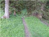 20
20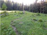 21
21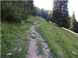 22
22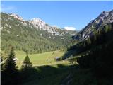 23
23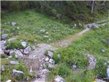 24
24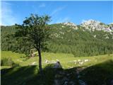 25
25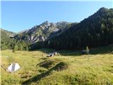 26
26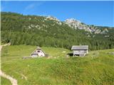 27
27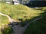 28
28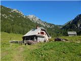 29
29
Discussion about the trip Rudno polje - Planina Konjščica
|
| capraibex24. 09. 2017 |
Between Koprivnik and Zajamniki quite a few smaller pastures, or planšarije, some completely abandoned. Does a path exist besides road leading through mentioned area?
|
|
|
|
| dezantone6. 08. 2021 11:56:18 |
How long does it take to hike from Rudno polje to Planina Konjščica?
|
|
|
|
| dezantone6. 08. 2021 11:57:58 |
Does anyone have the phone number of the cheese dairy on Konjščica?
|
|
|
|
| turbo6. 08. 2021 13:46:18 |
They might know more here:
Bohinjska sirarna, 041 889 610
(Monday to Friday from 7:00 to 15:00)
|
|
|
|
| exwannabe7. 08. 2021 11:16:50 |
For information, the hut on Planina Konjščica is closed (at least it was a week ago and nothing indicated it would open this year at all).
|
|
|
|
| Enka28. 06. 2022 21:00:24 |
This year it is possible again to refresh oneself and enjoy something good at the alpine dairy on Konjščica.
|
|
|
To post a comment you must log in:
If you do not yet have a username, you must first
register.