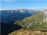
 | Ravenska Kočna - Vratca (past the cableway)
The peak of Vratca stands west of Češka koča and is recognisable by its tower-like shape. There is little space on the very summit, but it offers...
2 h 15 min |
| Ravenska Kočna - Vratca (umik Žrela)
The peak of Vratca stands west of Češka koča and is recognisable by its tower-like shape. There is little space on the very summit, but it offers...
2 h 20 min |
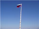
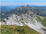
 | Pod Krnico - Koschutnikturm (Košutnikov turn) (western way)
Košutnikov Turn is the highest peak in Košuta, the longest Slovenian ridge. The summit offers a beautiful view of the entire ridge. Austria and t...
2 h 15 min |
| Pod Krnico - Koschutnikturm (Košutnikov turn) (eastern way)
Košutnikov Turn is the highest peak in Košuta, the longest Slovenian ridge. The summit offers a beautiful view of the entire ridge. Austria and t...
2 h 30 min |
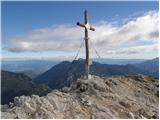
 | Planina Pungrat - Veliko Kladivo
Veliko Kladivo is a 2094 m high peak in the longest Slovenian ridge, Košuta. From the summit, which has a register box and stamp, there is a very...
2 h 15 min |
 | Podolševa (Rogar) - Govca (Olševa) (direct way)
Govca is the highest peak of the Olševa range, rising above Koprivna, Solčava, and Remšenik (Remšenik/Remschenig is a valley on the Austrian side...
2 h 10 min |
 | Podolševa (Sveti Duh, Strevc) - Govca (Olševa) (via Obel kamen)
Govca is the highest peak of the Olševa range, rising above Koprivna, Solčava, and Remšenik (Remšenik/Remschenig is a valley on the Austrian side...
2 h 30 min |
| Podolševa (Sveti Duh, Strevc) - Govca (Olševa)
Govca is the highest peak of the Olševa range, rising above Koprivna, Solčava, and Remšenik (Remšenik/Remschenig is a valley on the Austrian side...
2 h 15 min |
| Podolševa (Rogar) - Govca (Olševa) (via Obel kamen)
Govca is the highest peak of the Olševa range, rising above Koprivna, Solčava, and Remšenik (Remšenik/Remschenig is a valley on the Austrian side...
2 h 25 min |
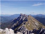
 | Ljubelj - Lokovnikov Grintovec / Grintoutz (via Koča na Ljubelju)
Lokovnikov Grintovec is a dwarf pine-covered peak north of Košutica, separated from it by Dovjakovo sedlo saddle (1,728 m). Its southwestern and ...
2 h 45 min |
 | Obertauern - Gamsleitenspitze (via Zehnerkar Sattel)
Gamsleitenspitze is a 2359-meter-high mountain in the Radstädter Tauern mountain group. From the summit, located above the Obertauern ski center,...
2 h 30 min |
 | Obertauern - Zehnerkarspitze
Zehnerkarspitze is a 2382-meter-high peak in the Radstädter Tauern group. The summit lies west of Obertauern pass above the ski center. From the ...
2 h 10 min |
 | Podolševa (Sveti Duh, Strevc) - Obel kamen (Olševa) (east path)
Obel kamen is a 1,911-meter-high peak located in the ridge of Olševa. On the summit is a border stone marked RS XXII 1; a cross and summit logboo...
2 h 15 min |
| Podolševa (Rogar) - Obel kamen (Olševa) (east path)
Obel kamen is a 1,911-meter-high peak located in the ridge of Olševa. On the summit is a border stone marked RS XXII 1; a cross and summit logboo...
2 h 10 min |
| Spodnje Sleme - Obel kamen (Olševa)
Obel kamen is a 1,911-meter-high peak located in the ridge of Olševa. On the summit is a border stone marked RS XXII 1; a cross and summit logboo...
3 h 30 min |
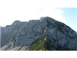
 | Nassfeld - Kronalpe / Monte Corona (Auernig Höhenweg)
Koren (Italian Monte Corona, German Kronalpe) is a 1,832-meter-high peak east of the Mokrine Pass, more precisely above the Vrh Krnice saddle on ...
3 h 30 min |