Planina Pungrat - Veliko Kladivo
Starting point: Planina Pungrat (1447 m)
| Latitude/Longitude: | 46,4286°N 14,3572°E |
| |
Walking time: 2 h 15 min
Difficulty: difficult marked way
Elevation gain: 647 m
Elevation difference along the route: 715 m
Map: Karavanke - osrednji del 1:50.000
Recommended equipment (summer):
Recommended equipment (winter): ice axe, crampons
Views: 25.607
 | 1 person like this post |
Access to starting point:
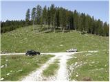
From the Ljubljana–Jesenice highway, take the Ljubelj exit. We then drive to the centre of Tržič and follow the road through Dolžanovo Gorge to the village of Jelendol, where signs for the mountain pastures Kofce, Šija and Pungrat direct us left. The road then loses its asphalt covering and starts to ascend steeply. We follow this road at the crossroads in the direction of the mountain pasture Pungrat, near which we park on one of the parking areas by the road.
Route description:
From the parking lot, we first walk to the mountain pasture Pungrat, then a few tens of metres before the cottages on the mountain pasture we turn left onto an extensive meadow, over which we ascend in a gentle rise to the edge of the forest, where we notice a mountain signpost for Škrbina (the initial part of the path is poorly marked).
We continue the ascent on a moderately steep forest path that rises above the mountain pasture Pungrat. After approximately 20 minutes of walking from the starting point, we step out of the forest onto increasingly steep slopes, first covered with brushwood then only with grass. The steep path brings us, with ever more beautiful views, after a good hour of walking to Škrbina, from which a view opens up onto the Austrian side.
From Škrbina we continue left in the direction of Veliki vrh (right Tegoška gora). The path ahead first crosses a steep grassy slope, then transitions to the ridge, which is occasionally somewhat exposed. Further on, we mostly ascend along the Slovenian side of the ridge, only occasionally does the path cross to the northern Austrian side. We follow this panoramic and locally very steep path, which except on a short section is not secured, along the partly exposed ridge to the summit of Kladivo, which we reach after approximately one hour of walking from Škrbina (in wet conditions and snow there is a great risk of slipping).
Starting point - Škrbina 1:10, Škrbina - Kladivo 1:05.

Photos:
 1
1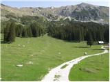 2
2 3
3 4
4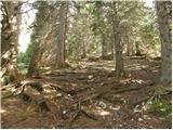 5
5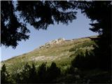 6
6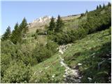 7
7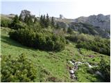 8
8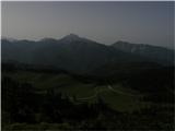 9
9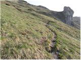 10
10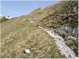 11
11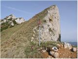 12
12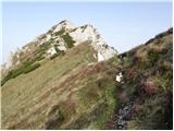 13
13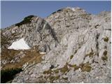 14
14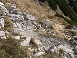 15
15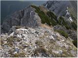 16
16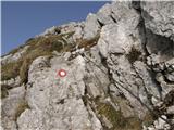 17
17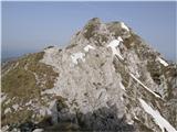 18
18 19
19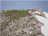 20
20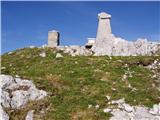 21
21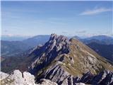 22
22
Discussion about the trip Planina Pungrat - Veliko Kladivo
|
| babim20. 08. 2017 |
Please provide a description of the path to Tegoška gora, I can't find it anywhere. I'm interested in the starting point, path description and conditions on this path. Thanks for the reply.
|
|
|
|
| babim23. 08. 2017 |
Today my husband and I did the tour Kofce-Šija-pl.Pungart-Škrbina-Pungartska gora. The road to Mrzli studenec is in much worse condition than a month ago. The marked path from pl. Pungart towards Škrbina up to the altitude where cows graze is very churned up. From Škrbina onwards to the summit caution is really needed all the time. We returned the same way and treated ourselves deservedly to excellent mushroom soup at Kofce, not to mention the cheese struklji!
|
|
|
|
| mornar24. 07. 2021 18:05:24 |
What is the condition of the road to Planina Pungrat. We would go with a small 20-seat minibus. Thank you and best regards.
|
|
|
|
| babim3. 09. 2021 10:02:43 |
I'm also interested in the condition of this road
with a regular passenger car? Thanks
|
|
|
|
| GITA3. 09. 2021 20:38:35 |
Hard to say how it would go with a minibus. I went to pl. Pungrat on 20.8. with a personal car (quite low) and it went more or less without problems, at two or three spots you need to be a bit more careful.
There are two possible accesses. In Jelendol, signs under the castle direct us left to planine Šija, Kofce and Pungrat. There it's better to keep right and continue towards pl. Dolga njiva, then at the marked junction turn left towards Pungrat. We got this info at Taborniški dom Šija and it obviously holds, because all others who turned left in Jelendol for Pungrat held their heads a bit when they got out of the cars... Have a nice hike!
|
|
|
|
| Klinar2719. 08. 2023 10:22:03 |
Does anyone know if the road to Planina Pungrat or to Planina Šija is passable after the recent floods?
|
|
|
|
| Spelcarocket21. 08. 2023 06:54:26 |
We didn't drive directly to Šija but to the chapel. It's drivable there, quite rutted but ok with a 4x4. A few cars parked at Pungrat. Good luck
|
|
|
|
| keti13. 10. 2025 08:47:04 |
Does anyone know what the current road to pl. Pungrat is like? Is the more winding one (towards Dolga njiva) better? Thanks!
|
|
|
|
| capraibex4. 10. 2025 08:28:33 |
With a personal car you can drive under planina Pungrat. Slowly and carefully.
|
|
|
|
| keti14. 10. 2025 21:21:21 |
Thanks! I tried it today. With a higher car and very carefully it worked
|
|
|
To post a comment you must log in:
If you do not yet have a username, you must first
register.