Podolševa (Rogar) - Govca (Olševa) (direct way)
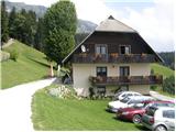
Starting point: Podolševa (Rogar) (1240 m)
| Latitude/Longitude: | 46,4355°N 14,6595°E |
| |
Route name: direct way
Walking time: 2 h 10 min
Difficulty: difficult marked way
Elevation gain: 689 m
Elevation difference along the route: 720 m
Map: Kamniške in Savinjske Alpe 1:50.000
Recommended equipment (summer):
Recommended equipment (winter): ice axe, crampons
Views: 124.526
 | 5 people like this post |
Access to starting point:
A) We drive to Luče (to here from Mozirje or from Kamnik over the mountain pass Volovljek (Kranjski Rak)), then continue driving towards Logarska dolina. In the village Solčava we leave the main road towards Logarska dolina and continue driving right in the direction of Podolševa, mountain pass Spodnje Sleme and Črna na Koroškem. Further on, the road loses its asphalt surface, and after a few kilometers at the junction in Podolševa we turn left in the direction of the panoramic road (right mountain pass Spodnje Sleme and Črna na Koroškem). Further, we drive towards the church of Sveti Duh, and we park already a few 100 m before the church on a suitable place by the road near the farm Rogar.
b) We drive to Črna na Koroškem (to here from Ravne na Koroškem or from Šoštanj over mountain pass Spodnje Sleme), then continue driving towards Luče. Initially still asphalt road, higher it becomes macadam and brings us to the junction of several roads on the mountain pass Spodnje Sleme. From the mountain pass we continue towards Solčava, then already somewhat lower we turn right in the direction of the panoramic road (by the left road we arrive in Solčava). Further, we drive towards the church of Sveti Duh, and we park already a few 100 m before the church on a suitable place by the road near the farm Rogar.
Route description:
From the starting point, we first walk to the tourist farm Rogar, from there we continue left on a cart track which starts to ascend through the forest. A little higher a cart track joins us from the left, which comes from the church of Sveti Duh, and we continue right on the marked path which leads towards Olševa. The cart track then changes into a footpath, which quickly brings us to the state border. Further, we ascend for some time along the state border, then we arrive at a marked junction, where we continue right in the direction of Potočka zijalka (left Remšenik / Remschenig).
From the junction follow approximately 10 minutes of steep ascent and we are already at the karst cave named Potočka zijalka.
From Potočka zijalka we continue on the marked path in the direction of Govca and we start to ascend steeply again. A little further we arrive at the next junction, where to the left branches off the path to Obel kamen (1911 m), and we continue right in the direction of Govca (Govca is the highest peak of Olševa). Follows crossing of the steep slopes of Olševa, on more exposed parts we are also helped by some steel cables. Further, the path turns to the left and joins us the path which leads over the peak Obel kamen. Here we continue right and start to ascend steeply on the increasingly panoramic slope. Higher the path levels out and leads us along the panoramic ridge, along which we quickly arrive at the highest peak Govca.

Along the route: Potočka zijalka (1700m)
Photos:
 1
1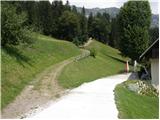 2
2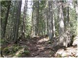 3
3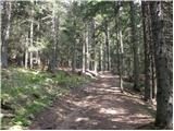 4
4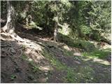 5
5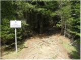 6
6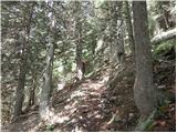 7
7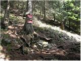 8
8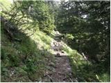 9
9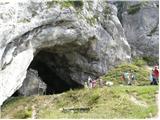 10
10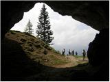 11
11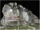 12
12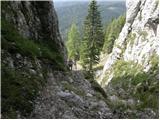 13
13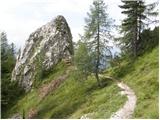 14
14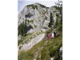 15
15 16
16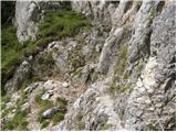 17
17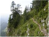 18
18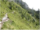 19
19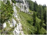 20
20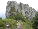 21
21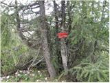 22
22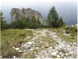 23
23 24
24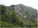 25
25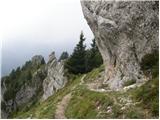 26
26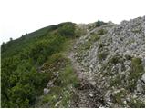 27
27 28
28
Discussion about the trip Podolševa (Rogar) - Govca (Olševa) (direct way)
Show older messages
|
| Gost22. 08. 2007 |
I recommend going first to Obel kamen and then from there along the upper part to Govca. The path is somewhat more difficult here, but the view is magnificent. Time-wise, it is not much longer.
|
|
|
|
| Gost22. 08. 2007 |
For Gorenjci, the best and shortest access is this one:
Drive to Jezersko, via the Jezerski vrh border crossing, past Bela (Bad Vellach) to the turn-off for Pavličevo sedlo, over Pavličevo sedlo past Majerhold and then left onto the road leading to Podolševa.
|
|
|
|
| legenda11. 07. 2009 |
I agree. Access to the starting point at Podolševa via Pavličevo sedlo is indeed the shortest for Gorenjci, for me also nicer than from Logarska dolina. Attaching some snapshots taken last autumn when I was roaming these areas.
|
|
|
|
| Pogačica19. 07. 2009 |
Please provide information on what (as Guest above writes) the path over Obel kamen being "somewhat more difficult, time-wise not much longer" means. Tomorrow we're heading to Govca via the path described above, but since we'll be with children, I'm still curious how much longer the path over Obel kamen is and if it's exposed. A photo from that section would be more than welcome. Thanks.
|
|
|
|
| geppo19. 07. 2009 |
With children maybe better to take the junction and go RIGHT not to Obel kamen. True though, the ridge one is nicer (MORE SCENIC). Judge yourselves how used children are to mountain hiking. There's just one section a bit harder for some, not others!!
No photos unfortunately!
Best
|
|
|
|
| Pogačica20. 07. 2009 |
Thanks geppo, we really preferred to skip Obel kamen this time, but even without it we enjoyed the views  . Wonderful trip! . Wonderful trip!
|
|
|
|
| Kozorog21. 07. 2009 |
Today was really a wonderful day... I missed the path to Obel kamen... the view is anyway by far the best on the "Slovenian" side so we enjoyed it exceptionally here...
|
|
|
|
| petruša19. 05. 2010 |
I'm interested what the conditions are like on Olševa, is there still any snow? lp
|
|
|
|
| geppo19. 05. 2010 |
Petruša, conditions here can be pleasant!
Lp
|
|
|
|
| petruša19. 05. 2010 |
Do you think there's no more snow on the path, because we'd go with children, we've been to Olševa once only in June. lp
|
|
|
|
| geppo19. 05. 2010 |
Petruša, I think there shouldn't be any special problems. But I advise against from Robanov kot!
Lp
|
|
|
|
| damijan6614. 09. 2010 |
I wonder if there are two parallel paths from Obel kamen towards Govca. We from the wooden cross walked along a path wide only for a foot, which crossed the slope somewhat below the ridge. Then, when we had nowhere else to go, we climbed to the ridge, where there is a border stone. The path is very narrow and runs along a very steep grassy slope and is very dangerous for slipping. We walked along it for about 15 minutes.
Is this the normal path or did we go astray?
Regards
|
|
|
|
| neph14. 09. 2010 |
Almost certainly you went astray. The path from Obel kamen to Govca does require some caution, but I don't remember anything like what you described.
|
|
|
|
| geppo14. 09. 2010 |
I think there is no other path along the ridge than the one you walked. It runs a little below the ridge then along the ridge and is momentarily dangerous for slipping. I haven't noticed any other option along the ridge than this one...
|
|
|
|
| bostjan8514. 09. 2010 |
damijan66, were you perhaps up there this Saturday (11.9.)?
|
|
|
|
| damijan6614. 09. 2010 |
neph and geppo: Thanks for your (different) answers
bostjan85: Yes, we were there this Saturday. You were probably in the group that kept overtaking us.
|
|
|
|
| damijan6614. 09. 2010 |
bostjan85
Hey, nice greeting from Prekmurje, nice photos.
geppo
I can't orient myself, I admit I was looking more at my feet. It's about the section of the path (about 15 minutes walk) from the cross to the border stone at the top of the ridge. There are no markers on or along the path.
|
|
|
|
| neph15. 09. 2010 |
Damijan66, I have to admit, I've only hiked this path once, and even then I wasn't paying much attention to the surroundings, so it's quite possible that my memory has deceived me a bit.
|
|
|
|
| EUGEN16. 09. 2010 |
Nice loop:
Sv.duh-okna-Obel kamen-Potočka-Sv.duh.
|
|
|
|
| marinka674. 10. 2010 |
On Saturday we were on Olševa via Obel kamen. Gorgeous weather, but in the boxes at Skala and Govca everything wet, no traverse stamp at all, logbook soaked and completely destroyed. So we stamped a triangular stamp with ballpoint ink in the traverse log, of course nothing is visible. Shame! Same story at Potočka zijalka. PD Luče, get to work!
|
|
|
|
| bostjan855. 10. 2010 |
at the bottom at the start, at the Rogar farm you have all the stamps
|
|
|
|
| marinka675. 10. 2010 |
Thanks boštjan85, but how should I know that? Too bad, too bad, because I don't know if we'll hike around there again. Too bad, too bad, because I don't know if we'll hike around there again.
|
|
|
|
| bostjan855. 10. 2010 |
we didn't know either, so we went to spend the night somewhere and asked  
|
|
|
|
| marinka675. 10. 2010 |
We also went to sleep and eat something, but we didn't ask  And the landlady even asked us if we had been up there, but she didn't tell us she had stamps. But the logbook at the top is soaked, you can't sign it Anyway, bad luck, what a shame etc.... And the landlady even asked us if we had been up there, but she didn't tell us she had stamps. But the logbook at the top is soaked, you can't sign it Anyway, bad luck, what a shame etc....
|
|
|
|
| petruša21. 10. 2010 |
Hello, I'm interested if anyone has been to Olševa in the last few days. What are the conditions like, has any snow fallen in these days, because we're going on Saturday. Thanks in advance
|
|
|
|
| Matjaz_656. 11. 2010 |
suggestion for a circular hike ... as I did it today
from the junction of the Solčava panoramic road in Podolševa .. past Rogar and Potočka zijalka .. and along the ridge from Obel kamen to Gladki vrh ... from where descend to the starting point
a few more photos
|
|
|
|
| damijanp7. 11. 2010 |
@Matjaz65: Yesterday we were, it seems, together on Govca - on one of your photos my daughter and I are in the background. My photos are at:
Olševa
|
|
|
|
| grinhorn7. 11. 2010 |
Hehe there was a crowd up there yesterday, I saw you two up there too. Damijanp you have a private message
|
|
|
|
| lej16. 01. 2011 |
Today on Olševa. Wonderful weather and even better views. Very few hikers. Snow for this time of year just a trace. Lp
|
|
|
|
| babim27. 07. 2011 |
Today my husband and granddaughter and I were at Govca. Nice weather, nice path. Since we wanted to make a circular route, we returned along the ridge over Visoka peči and Gladki vrh, then descended to Podolševa. This descent is extremely steep, moreover the path was wet and slippery, wet roots and it was very hard to descend, sometimes even on your butt. Then of course a few km on foot along the road to the car waiting in sv. Duh. At Visoka peči we met the shepherd, a hunter, vet inspector and another companion, because yesterday they found a couple of torn sheep and wanted to find the attacker. We got a bit uneasy feeling, but we were focused on the descent and forgot about it. Nice trip!
|
|
|
|
| panda3. 08. 2011 |
Today I tried the path described by "babim". Up the classic to Govca via Potočka zijalka, continuation along the ridge to Gladki vrh, then down to Podolševa. The descent that took about 2 hours (descent of 850 m) is a hair-raising ordeal even when dry, let alone wet. Then another 3 km to the car at Sv. Duh. I will never go down this path again, nor up.
|
|
|
|
| jprim3. 08. 2011 |
I have walked it once myself; it was the best choice ahead of the thunderstorm and already light rain—at that time this forest was full of large foxglove flowers.
In this case, even the Calvary on Begunjščica does not seem steep to me.
|
|
|
|
| arker25. 09. 2011 |
22.9 my friend and I were on Govca - wonderful!!!!
|
|
|
|
| msevsek21. 10. 2011 |
Tomorrow departure to Olševa. Route Sv. Duh-Olševa. I hope there's still some snow left so we can do a bit of postholing
|
|
|
|
| dprapr23. 10. 2011 |
The mini Aljažev stolp is on Obel kamen, or on the adjacent lower peak, in the direction of Logarska dolina.
Lp
|
|
|
|
| jvali20. 10. 2012 |
Today my sister and I spent the day on Olševa. Magical! Summer weather, clear views, autumn provided golden larches and colorful foliage. We also met friends. The day was more than beautiful. Valerija
|
|
|
|
| Šmarčan12320. 07. 2013 |
Help. Today I lost a bunch of keys on the path from Sv. Duh to Govca. The keys are on a keyring with an R/M-dark red strap. They might also be around the church, where the parking is.
If someone finds them by chance...
Otherwise today was nice, not too hot, we had a great time, nice view, nice path, flowers on the path...
|
|
|
|
| šoni4. 11. 2013 |
The climbers placed their sign "Olševa 1929" (which is the elevation of Govca) right on Obel kamen, which is of course lower and completely at the other end of Olševa's highest summit. They quite disappointed me with their knowledge of the mountain.
|
|
|
|
| Janiel7430. 04. 2014 |
Does anyone have info on what the conditions are like on this path? Probably still some snow?
|
|
|
|
| franjo6615. 05. 2014 |
What are the conditions like?
|
|
|
|
| nordkap23. 09. 2014 |
Has anyone perhaps been on Govca-Olševa in the last few days and I'm curious if they've put the stamp back, since it wasn't there a long time ago.
|
|
|
|
| brina23. 09. 2014 |
the stamp is attached to the shelter
|
|
|
|
| jure197723. 09. 2014 |
Can someone perhaps suggest which variant is better: Obel kamen-Govca or vice versa?
We start the tour normally at Rogarju, then to Potočka zijalka, further on I'm interested if there's any significant difference between the variants or not. Thanks in advance!
|
|
|
|
| brina23. 09. 2014 |
I prefer to go first to Govca, then along the ridge to Obel kamen, mainly because of the nice views, and also because of better visibility of the path on the initial steepest part of the ridge path
|
|
|
|
| jure19773. 11. 2014 |
Yesterday we were on Olševa (Rogar - Potočka zijalka - Govca - Obel kamen (along the ridge) - Rogar). The path is normally passable, there is a little snow on the path (just before arriving at the ridge towards Govca), but it was quite warm, so the path is normally passable.
|
|
|
|
| mashyms23. 12. 2014 |
On Sunday I was on Olševa, conditions excellent, almost no snow, just a little sample
|
|
|
|
| franjo6625. 03. 2015 |
What are the conditions.....
|
|
|
|
| MBrando25. 04. 2015 |
I'm also interested, pje!
|
|
|
|
| jprim25. 04. 2015 |
Interesting discussion , @franjo66 probably overlooked the date of the Olševa visit ... it has snowed quite a few times since then.
Yes, I'm really interested too.
LP!
|
|
|
|
| gmirko26. 06. 2015 |
Can one get past the cable-protected sections of the path from Potocka zijalka to Govca with a dog accustomed to hills? Thanks.
|
|
|
|
| Matjaz_6515. 11. 2015 |
circular tour from the intersection of the Solčava panoramic road in Podolševa .. past Rogar ... jump to Velikih Lipšev vrat ... return to Potočka zijalka .. and along the ridge from Obel kamen to Gladki vrh ... and descent to the starting point
photos
|
|
|
|
| geppo16. 11. 2015 |
You could save some distance and climb directly from the gates to Obel kamen...
best regards
|
|
|
|
| seinfeld19. 06. 2016 |
We did this trip yesterday. The trail is nice, without noteworthy steepness, all the time with beautiful views. Also the above-mentioned exposed sections, those almost aren't. Including stops and cave visit, we took 4.5 hours for up and down (7km).
But it's interesting how late some start into the mountains. When we were at the car at 12:30, some were just starting. And by then the trail was already strongly sunlit, and it was already raining above Ojstrica.
|
|
|
|
| jprim19. 06. 2016 |
Your comment is subjective, what is in the trail description, I think it fits. The trail is steep in certain sections and also partly exposed below the summit.
Nice
|
|
|
|
| jprim19. 06. 2016 |
I slightly misunderstood your comment, my comment refers to the trail from Slemen.
LP.
|
|
|
|
| fcr29. 07. 2016 |
Tomorrow my wife and I plan to go to Govca from the Rogar farm. We'd like to go via Obel kamen too, so I'm interested regarding exposure and views whether it's better to go to Obel kamen first and then to Govca or on the way back. Thanks and regards.
|
|
|
|
| zokica29. 07. 2016 |
I recommend Rogar - Vrata (on the Austrian side. The path there branches off about 15 min. before Potočka zijalka)Then the path under Vrata, then directly to Obel kamen and along the ridge to Govca.
Refreshment at Vrata obligatory, it's also good to have some protection (5 m rope + carabiner), otherwise the path is secured with cable and pegs at exposed spots. But it's worth seeing this.
From Govca then towards Potočka no need to go to Obel kamen anymore.
|
|
|
|
| drdivx29. 07. 2016 |
@zokica I'd add a few things.
I don't know what to attach to on that part of the trail, because almost all pegs holding the steel cables are out. I advise against this trail for those with vertigo, as it's slightly exposed and almost unsecured.
There is also access via middle and small gates, which is not easy for the inexperienced.
Now the answer for @fcr
Between Obel kamen and Govca, I mean the ridge trail, there is one spot that's a bit awkward. It bothers some, others don't have issues there.
|
|
|
|
| drdivx29. 07. 2016 |
@fcr
The most important thing I forgot to write.
It doesn't matter which summit you visit first. Personally, I would go to Govca first and then to Obel kamen on the return.
Take a look at the pictures in the trail description and then decide.
|
|
|
|
| fcr1. 08. 2016 |
Thanks for the tip. There we decided to go via Potočka to Obel kamen. The path was nice, no issues. At Obel kamen two came from Austrian side, but didn't praise the path much - quite demanding, they said. Otherwise wonderful, views fantastic.
Then from Obel kamen to Govca along the ridge. The path was quite passable up to the last descent to Govca, which is very steep - almost vertical. There could be ca 3m wire ropes installed for the rocky descent to improve safety. Then this truly unique path would be suitable for all. As is, ..., pity.
|
|
|
|
| m1234514. 08. 2016 |
Today with my son visited Govca, at the summit the logbook is completely full, so we couldn't sign in. That's the only thing that slightly spoiled the wonderful trip and summit views for us.
Best regards.
|
|
|
|
| nordkap15. 08. 2016 |
m12345,
already 3 weeks ago I pointed out this book that's noted everywhere and full as an emperor's purse, I also mentioned it at the farm below and they said they'd notify the responsible ones to replace it.
Seems in this SLO you can't trust anyone anymore.
But the book and bureaucracy can't spoil the day and enjoyment for me.
That day I was completely alone on the mountain, no living soul anywhere and I really enjoyed it 100%.
As icing on the cake, at Sv. Duh I could take a panoramic photo towards KSA, as the day was very clear, had KSA right there, really close-up, phenomenal, so perfect day despite the book, ha ha.
|
|
|
|
| Andrej4525. 09. 2016 |
Very well marked path, suitable for day hikers with very good panoramic views. Potočka zijavka cave is just an additional point that spices up the trip itself.
|
|
|
|
| vongerster31. 10. 2016 |
Wonderful path, excellently marked, and for the conclusion a beautiful panoramic view.
It's nice if the weather is a bit misty, the ideal time for a visit is October-November. Nature changes colors, almost no fog, and it's not too cold for such an endeavor ...
nordkap; the books have been replaced with new ones at Govca, Potočka Zijalka and on Olševa, dated from 15.10. - that was when the first entry was recorded.
And some snapshots from the path.
https://drive.google.com/drive/folders/0BzZcGfi2NpbvTC10QU1qQ2o3Q2s?usp=sharing
|
|
|
|
| sasgittariusvz22. 05. 2017 |
Hello, does anyone know what the path from Gladki vrh towards Štftar is like? (Through Majdačev hrib)
|
|
|
|
| MojcaVi26. 06. 2019 |
On this path to Olševa three weeks ago. Neither at Potočka zijalka nor summit any stamp for book. In between some fallen trees right on path.
Otherwise nice path with wonderful views accompanying us.
|
|
|
|
| Driada21. 02. 2020 |
Has anyone taken this path in the last few days? What are the conditions?
|
|
|
|
| J.P.5. 09. 2020 |
Today we chose the path via Zijalka to Govca and back via Obel kamen. Nicely maintained path. Views so beautiful that one keeps turning around. Truly a panoramic path of the Karavanke. Best regards
|
|
|
|
| Najed15. 08. 2021 19:11:36 |
Today on Olševa... Up via Obel kamen, to Govca and back to Rogar... Approx. 4.5 hours... Quite hot... Path great
|
|
|
|
| jvrcko4. 02. 2022 16:35:16 |
What are the conditions on this path? How much snow? Trodden? Icy? Dangerous? Wire ropes and pegs out? Crampons mandatory?
|
|
|
|
| zokipoki5. 02. 2022 16:22:20 |
Winter gear mandatory! Regards
|
|
|
|
| Mona15. 05. 2024 06:00:07 |
Please help
What is the road to Rogar farm like? Is it gravel?
|
|
|
|
| djimuzl15. 05. 2024 06:32:33 |
In any case, some gravel awaits you, also in the approach from the direction of Pavličevo sedlo, which is not described in the "Access to the starting point" section. A possibly more suitable parking spot is under the church, from where it's not far to Rogar.
|
|
|
|
| Tomaž0016. 05. 2024 05:44:44 |
And on the path to Olševa, is there still any snow?
|
|
|
To post a comment you must log in:
If you do not yet have a username, you must first
register.