Pod Krnico - Koschutnikturm (Košutnikov turn) (western way)
Starting point: Pod Krnico (1250 m)
| Latitude/Longitude: | 46,4346°N 14,4083°E |
| |
Route name: western way
Walking time: 2 h 15 min
Difficulty: difficult marked way
Elevation gain: 883 m
Elevation difference along the route: 883 m
Map: Karavanke - osrednji del 1:50.000
Recommended equipment (summer):
Recommended equipment (winter): ice axe, crampons
Views: 121.239
 | 5 people like this post |
Access to starting point:
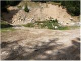
From the highway Ljubljana - Jesenice, we head to the exit Ljubelj. From this road before the gas station, we turn right to Tržič. The road then quickly brings us to Tržič, and we follow it further in the direction of the villages Jelendol and Medvodje. In the village Medvodje, we turn left towards Košuta on the forest road which we follow to a crossroad at Košutnik (house) approximately at 1000m. Here we go right and we drive to the parking lot at a smaller quarry.
Route description:
From the parking lot, we go on a cart track which branches off left from the road. The cart track goes into the forest and is moderately ascending, first crossing a smaller and then a bigger stream. The cart track, which has some shortcuts, makes some turns and after a good 15 minutes brings us on the pastures of the mountain pasture Spodnja Dolga njiva.
After a short walk on the mountain pasture, the path brings us to a crossing, where there are signposts. We go left in the direction of Košutnikov turn (straight Košutnikov turn east path) and after a few steps the path brings us into the forest, where it starts gently ascending. The path ahead crosses a grazing fence and soon after that brings us to the next crossing, where we go sharply right in the direction of Košutnikov turn (straight Tegoška mountain pasture). A moderate ascent follows through the spruce forest from which the path brings us on a narrow and high clearing. The path then ascends by this clearing in numerous zig-zags relatively steeply upwards. Above the clearing, the path crosses a short lane of forest and brings us on the upper unvegetated slopes of Košuta. Here the path turns a little towards the left and after a few minutes gets quite close to one of numerous gullies in the ridge of Košuta. Right at the spot where the path gets close to the gully, the marked path to Košutnikov turn turns sharply right.
The path ahead in a gentle ascent crosses grassy slopes, which are in some parts overgrown with dwarf pines towards the east. The path then again steeply ascends and brings us into a small steep valley between Košutnikov turn on the right and the less known peak Ostrv on the left. Here the path ascends even steeper and in a few minutes of ascent brings us on the border ridge, where a view opens up towards Austria. Here the climbing path coming from the Austrian side also joins us.
We continue right on the more and more rocky slope, which soon bypasses a less noticeable window in the ridge. The steepness on the path increases and in front of us we notice a steep rocky jump which is about 10m high. On this part we have to help ourselves with hands, because the path is very steep and in wet very dangerous. The still steep path then soon brings us on the ridge, where the steepness decreases. We follow the path, which runs on the in parts exposed ridge, to the peak, which we reach in a few dozen strides of additional walking.

Photos:
 1
1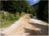 2
2 3
3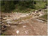 4
4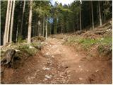 5
5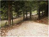 6
6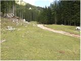 7
7 8
8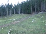 9
9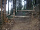 10
10 11
11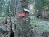 12
12 13
13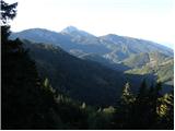 14
14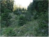 15
15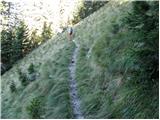 16
16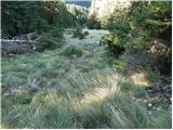 17
17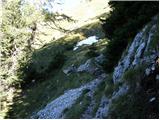 18
18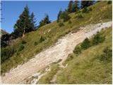 19
19 20
20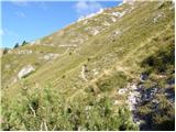 21
21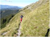 22
22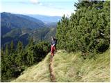 23
23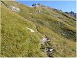 24
24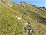 25
25 26
26 27
27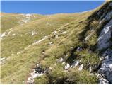 28
28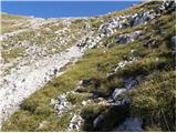 29
29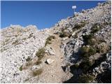 30
30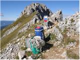 31
31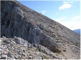 32
32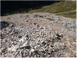 33
33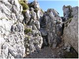 34
34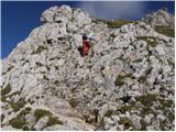 35
35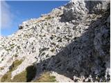 36
36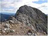 37
37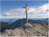 38
38
Discussion about the trip Pod Krnico - Koschutnikturm (Košutnikov turn) (western way)
|
| andrej jerina21. 10. 2008 |
I also climbed to K. turn today via the described route. The path was dry, views beautiful. It must be admitted that the path is quite steep in places, in wet conditions high risk of slipping. From the saddle I extended the route to Ostrv, where I silently remembered the young mountaineer who ended his youth there last week, then continued to the Macesja ridge. The ridge path itself is not for those afraid of heights, a sure step is needed as there's almost no chance to stop in case of a fall. From K. turn I descended via the "eastern" approach, which in my opinion is nicer. One needs to be very careful on the path as there are quite a few gullies towards planina Dolga njiva. I recommend it for descent. LP Andrej
|
|
|
|
| jprim14. 01. 2009 |
In the description of the eastern path, which I myself used for descent and which is really wonderful, there is a mention of the place where we must be careful about the presence of vipers. The warning is entirely appropriate, as I experienced an encounter with one, good thing my husband and I were careful about the path itself - our feet, otherwise I would have stepped on it. Just a little additional warning, even though there is now deep snow ... but spring is almost here and ...
Best regards!
|
|
|
|
| Mate076. 06. 2010 |
If anyone goes from Planina Pungrat to Košutnikov Turn, the path is destroyed due to avalanches, so at your own risk go to Škrbina and then continue towards Košutnikov Turn, the path itself at the beginning and almost to the top of KT is exposed, so be careful. The last 50 meters is the demanding part of the path, I preferred to stay there rather than venture into that narrow ridge, which is secured; without a harness you have no business there.
|
|
|
|
| viharnik6. 06. 2010 |
Mate!, from Pl. Pungrat to Košutnikov Turn is a real tough path that only few mountaineers tackle in its entirety. Usually they take the upper path already from Tegoška Planina and first cross Ostrv, then either below along the narrow path around the mountain or directly over the Ostrvi ridge on a more difficult and exposed path that descends to the saddle where it joins the normal route from Dogih Njiv.
Pungrat offers via Škrbina 1869m a nice circular tour to Kladivo or Tegoška Gora.
The Košuta ridge itself is about 12km long with over 10 peaks above 2000m...
|
|
|
|
| Mate076. 06. 2010 |
Well, I've been to almost all of them, just not to Kladivo (small-big).
|
|
|
|
| viharnik6. 06. 2010 |
You probably meant the destroyed path from Dolgih Njiv to Košutnikov Turn and not from Pl. Pungrat, which is completely on the other side of Košuta? Already last year only the upper - last 100 m rocky ridge towards the summit had collapsed.
|
|
|
|
| Mate077. 06. 2010 |
Not from Planina Pungrat, right above the hut there is a sign and below it also says that the path is impassable (avalanche).
|
|
|
|
| Parkeljc7. 06. 2010 |
On Saturday I went up the western and down the eastern. When I reached Planina Zgornja Njiva I noticed quite a few hikers climbing the ridge towards Tolsta Košuta. Only when I reached the saddle between M. Košuta and T. Košuta did I see that the path is much more scenic and is not marked anywhere or drawn on the map. I was sorry I didn't take the mentioned path to KT, but I'll do it soon.
Somehow right below the top of KT I had a close encounter with a smooth snake, which luckily just crossed the path right in front of me. It was quite a big piece, at least half a meter long, brrr.
Since I had some time left, I went along the state border to the nearby peak Malo Košuta and then to Plešivec, from which there is a nice view of the entire Košuta ridge.
|
|
|
|
| Mate077. 06. 2010 |
Sorry for the misspelled word Pungart, correcting to Pungrat.
I went up from this mountain pasture naturally via pathless terrain, there is no path.
I also encountered a snake.
|
|
|
|
| matejd12. 06. 2010 |
I was there last weekend - 6.6. - met a smooth snake - about 15 cm.... small youngster  ... otherwise very nice. Recommend. Otherwise I wanted to go to Ostrv but forgot the map at home and climbed the mountain left of the Turn but unfortunately it wasn't the one Next time... otherwise highly recommend. Super views. ... otherwise very nice. Recommend. Otherwise I wanted to go to Ostrv but forgot the map at home and climbed the mountain left of the Turn but unfortunately it wasn't the one Next time... otherwise highly recommend. Super views.
|
|
|
|
| Moyca16. 07. 2011 |
Today I was at K. turn. Up a super fast path on the west side, for descent a divinely beautiful panoramic path on the east side. Really recommend.
|
|
|
|
| urbancek16. 07. 2011 |
Strange about smooth snakes, but are you sure?
Because up there vipers were common until recently... for smooth snakes that's quite high altitude, you rarely see them above 1500m...
Well, in the end it doesn't matter
Best regards!
|
|
|
|
| klm16. 07. 2011 |
Smooth snakes live only in the montane belt, so we'll encounter them in lower areas, higher, in the altimontane and alpine belts up to 2000 m, vipers live.
|
|
|
|
| urbancek16. 07. 2011 |
That's why, I've met a viper up there twice and always vipers... If you're not an expert you can confuse them...
|
|
|
|
| vespuci1. 10. 2011 |
It's sad that there is no stamp at Košutnikov turn!
|
|
|
|
| CarpeDiem2471. 10. 2011 |
I'm not an expert on snakes and reptiles, but isn't the smooth snake more grayish (has the famous rožićek), while the viper is brown (I've seen it many times very close up) and has a checkerboard pattern, if I'm not mistaken. They are actually quite different. The Laški viper is a bit different, but I think they live only near Soča, and there aren't many of them around here.
|
|
|
|
| urbancek1. 10. 2011 |
@CarpeDiem247: That vipers are only brown is nonsense... Viper can be just as gray as smooth snake. Brown, larger or longer ones are usually female vipers... Otherwise, smooth snake has many more shades than viper, smooth snake is basically gray, but can also have shades from greenish, orange, even brown (large females) etc. Viper is mostly brown, gray, or black, Laški one has a slightly different shade, but is quite rare...Snakes are better observed holistically and not just by e.g. color... Anyone who has delved a bit into this and encountered and observed viper and smooth snake up close in their life will NEVER confuse them again, because they are just too different... Ignoramuses though... anything is possible... Like recently somewhere in our mountains, when people couldn't distinguish ibex from chamois... Regards! Regards!
|
|
|
|
| CarpeDiem2471. 10. 2011 |
Good thing Zlatorog didn't appear to them, what a mess that would have been then. Well, maybe he did later, but the one on the store shelves! 
|
|
|
|
| benkjani2. 10. 2011 |
Hello! Today at the parking lot by the Quarry I forgot a dark blue strap (on a wooden board). Honest finder, if you find it, please call me at 040 740-013 Miha!
|
|
|
|
| sirt13. 10. 2011 |
I have a picture of a snake from the eastern path below Košutnikov turn, but I can't attach it! Can someone help me.
|
|
|
|
| metod15. 10. 2011 |
Such peaceful narrow paths through warm south-facing meadows above the tree line are really to my liking! Today it was exactly like that.
|
|
|
|
| Ajda_Zitnik28. 11. 2011 |
I hiked the path yesterday. The path was still completely dry.
I would add to all the information that in my opinion it is not for those afraid of heights.
|
|
|
|
| sirt129. 08. 2012 |
Yesterday up there again. Fairy tale. View from Gorski kotar in the south to snow-covered Veliki Klek in the north and everything in between without a cloud.
|
|
|
|
| Lunca13. 10. 2014 |
Part of the path was swept away by an avalanche... specifically at the spot where the path to the summit branches left uphill, straight ahead the path continues under the summit towards the eastern path... The issue isn't "fresh", but I see no one has written about it here yet. The branch is marked with a cairn.
|
|
|
|
| malimiha23. 12. 2016 |
Hi, I'm interested in the current conditions. Is it dry? Lp
|
|
|
|
| Lunatic23. 12. 2016 |
10 days ago it was dry...
|
|
|
|
| tagec24. 12. 2016 |
The path is dry, both the eastern and the western path, on which we ascended on this beautiful Friday.. LP
|
|
|
|
| danielenidoma4. 11. 2017 |
The road to the starting point is ok, the path without features, with my son (10 years) we chose this path yesterday for a trip to conclude the holidays It requires a great deal of caution though, dangerous for slipping .. not recommended for those afraid of heights .. below the summit some free climbing is needed. We missed the inscription on the stone saying left and went ahead on the already trodden path. Thanks to the friendly hiker who directed us back to the west path. Then we were more careful and indeed missed the mark which is quite hidden or already poorly visible. Zigzagging to the top good luck to all heading to this path, you won't regret it
|
|
|
|
| franjo6626. 05. 2018 |
Where is the village Medvodje?
|
|
|
|
| PUHIPUHI26. 05. 2018 |
Is this path already completely dry or do you still need to cross some snow fields?
|
|
|
|
| J.P.31. 07. 2019 |
Nice peak, not too crowded. Good destination for those who would dash to a two-thousander during the week before afternoon work. Drive is approx. 1.10h, hike 1.40h. Of course, time depends on many things and serves only as a base. Safe steps. Regards
|
|
|
|
| georgia1. 08. 2019 |
It tempts me, I admit.
But isn't the road through Dovžanova soteska closed now due to renovation until November? Or how is access to the starting point currently? 
|
|
|
|
| sirt11. 08. 2019 |
Tržič - Lom - Potarje - then left-right, up-down along the forest road to Medvodje.
|
|
|
|
| georgia2. 08. 2019 |
Aha, thanks. But the summit will wait for better times or roads. It's not that desirable right now.
|
|
|
|
| djimuzl2. 08. 2019 |
The closure will be from Monday, 5.8., onwards. This weekend you still have the opportunity.
|
|
|
|
| Lunca2. 08. 2019 |
The works have been going on all week and with that also occasional closures. They will also be carried out tomorrow and on Sunday. On 5.8. there will be a complete closure from address Jelendol 3 onwards between 7 and 17, on 6.8. from address Dolina 31. For further it's not known yet.
|
|
|
|
| Lunca2. 08. 2019 |
The detour road via Lom extends the route by at least 15km one way.
|
|
|
|
| sirt13. 08. 2019 |
Lunca, don't exaggerate. From Slap(Tržič) to Medvodje it's 15km. That the path is extended by 15km applies to the residents of the Valley, who have to drive the entire route and also through Jelendol back to the Valley.
|
|
|
|
| Lunca3. 08. 2019 |
That won't hold up at all, already on the normal road from Tržič to Jelendol it's 6.5 km and then to the turn-off for Vetrh another 3.5. On the detour you go from Tržič first to Lom, through Potarje, Vetrh and to Medvodje, on a road where you don't want to take a vehicle you care about even a little.
|
|
|
|
| anica.zu14. 08. 2023 15:10:47 |
I'm wondering what the road to the starting point is like given the heavy rains last week.
|
|
|
|
| ucakakla4. 09. 2023 09:16:31 |
anica.zu: I drove the path to the starting point last Thursday. Apart from two larger holes towards the end of the path, everything can be nicely driven even with a lower car. I have a slightly raised car and it went without problem to the end, otherwise park a little lower, about a kilometer before.
|
|
|
|
| ucakakla4. 09. 2023 09:21:58 |
I'm interested in the easiest path to conquer both the summit of Košutnikov turn and Tolste Košute?
|
|
|
|
| anica.zu1. 10. 2023 14:49:08 |
ucakakla: I think you can't do the ridge at once. But you can go first to Planina Zg. dolga njiva, from there climb to Tolsta Košuta, back down to the pasture, from where you climb to Košutnikov Turn via the eastern path. Down via the shorter, western path to Planina spodnja dolga njiva. Of course you can go the other way too. The starting point is in any case at Planina Spodnja dolga njiva.
|
|
|
|
| garmont1. 10. 2023 17:30:30 |
Traversing Tolsta Košuta - Košutnikov Turn is an easier alpinistic feat. There are also descriptions of traversing this ridge on this portal.
|
|
|
To post a comment you must log in:
If you do not yet have a username, you must first
register.