 | Aljažev dom v Vratih - Dolkova špica (western way)
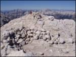
Dolkova špica is a 2,591 m high mountain situated between Stenar and Škrlatica. From the summit, where the summit register box is located, a beau...
5 h 15 min |
| Zadnjica - Dolkova špica
Dolkova špica is a 2,591 m high mountain situated between Stenar and Škrlatica. From the summit, where the summit register box is located, a beau...
7 h 5 min |
 | Zadnjica - Kanjavec (via Dolič)
Kanjavec is a 2569 m high mountain located between Dolič and Hribarice. From the top, which has a registration box and a stamp, we have a beautif...
6 h 35 min |
 | Koča pri Savici - Kanjavec (via Triglavska jezera)
Kanjavec is a 2569 m high mountain located between Dolič and Hribarice. From the top, which has a registration box and a stamp, we have a beautif...
6 h 30 min |
| Aljažev dom v Vratih - Kanjavec
Kanjavec is a 2569 m high mountain located between Dolič and Hribarice. From the top, which has a registration box and a stamp, we have a beautif...
7 h |
 | Suhadolnik - Grintovec (via Streha)
Grintovec is the highest peak in the Kamnik and Savinja Alps. It is located above the valley of Kamniška Bistrica, Suhi dol and above the valley ...
4 h 45 min |
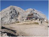
 | The Kot Valley - Triglavski dom na Kredarici
Triglavski dom na Kredarici is Slovenia's highest-serviced mountain hut. It is open all year round, but outside the season only on an emergency b...
5 h 10 min |
 | Zadnjica - Triglavski dom na Kredarici
Triglavski dom na Kredarici is Slovenia's highest-serviced mountain hut. It is open all year round, but outside the season only on an emergency b...
7 h 30 min |
 | V Koncu - Skuta (via Kokrsko sedlo)
Skuta is a 2532 m high mountain located in the heart of the Kamnik-Savinja Alps. From the top, where there is a registration box and a stamp, we ...
5 h 30 min |
| Suhadolnik - Skuta (via Kokrsko sedlo)
Skuta is a 2532 m high mountain located in the heart of the Kamnik-Savinja Alps. From the top, where there is a registration box and a stamp, we ...
5 h 45 min |
 | B station - Prestreljenik (via Krnica)
Prestreljenik is a 2499 m high mountain located in the heart of the Kanin Mountains. From the top, where the Aljaž Tower-shaped registration box ...
4 h 25 min |
 | Pišnica - Špik (via Kačji graben)
Špik is a 2472 m high mountain located in the heart of the Martuljek Group. From the top, which is clearly visible from the road leading through ...
4 h 40 min |
 | The Kot Valley - Begunjski vrh
Begunjski vrh is a 2461 m high mountain located in the heart of the highest mountains in the Julian Alps. From the top, which has a registration ...
4 h 40 min |
 | Jermanca - Planjava (via Kamniško sedlo)
Planjava is a small mountain range east of Kamniško sedlo. It has two peaks, eastern and western. A marked trail leads to the eastern peak, which...
4 h 30 min |
| Pred Belo - Planjava
Planjava is a small mountain range east of Kamniško sedlo. It has two peaks, eastern and western. A marked trail leads to the eastern peak, which...
7 h |
 | Na Razpotju - Planjava
Planjava is a small mountain range east of Kamniško sedlo. It has two peaks, eastern and western. A marked trail leads to the eastern peak, which...
5 h |
| Dom Planincev v Logarski dolini - Planjava
Planjava is a small mountain range east of Kamniško sedlo. It has two peaks, eastern and western. A marked trail leads to the eastern peak, which...
4 h 55 min |
 | Laško - Storžič (via Sveti Lovrenc and over Bašeljski preval)
Storžič is a 2132 m high mountain located in the western part of the Kamnik-Savinja Alps. From the summit, where there is a cross, there is a bea...
4 h 30 min |
| Bašelj - Storžič (via Sveti Lovrenc and over Bašeljski preval)
Storžič is a 2132 m high mountain located in the western part of the Kamnik-Savinja Alps. From the summit, where there is a cross, there is a bea...
5 h 5 min |
 | Dom v Kamniški Bistrici - Brana
Brana is a mountain above Kamniško sedlo. From the spacious summit, which has a registration box and a small cross, there is a very beautiful vie...
5 h |
 | Podrožca / Rosenbach - Mittagskogel/Kepa
Kepa, also known as Jepa or Mittagskogel in German, is a panoramic mountain in the western Karawanks, located on the border ridge between Sloveni...
5 h 10 min |
| Čemernica / Tschemernitzen - Mittagskogel/Kepa
Kepa, also known as Jepa or Mittagskogel in German, is a panoramic mountain in the western Karawanks, located on the border ridge between Sloveni...
5 h 5 min |
 | Pred Belo - Ojstrica
Ojstrica, named after its sharp shape, rises steeply above the Korošica River, the Logar Valley and Robanov Kot. From the top, where the registra...
6 h 45 min |
 | Robanov kot - Ojstrica (via Mala Ojstrica)
Ojstrica, named after its sharp shape, rises steeply above the Korošica River, the Logar Valley and Robanov Kot. From the top, where the registra...
5 h 15 min |
 | Pred Belo - Ojstrica
Ojstrica, named after its sharp shape, rises steeply above the Korošica River, the Logar Valley and Robanov Kot. From the top, where the registra...
6 h 45 min |
| Robanov kot - Ojstrica (via Kocbekov dom)
Ojstrica, named after its sharp shape, rises steeply above the Korošica River, the Logar Valley and Robanov Kot. From the top, where the registra...
5 h 45 min |
 | Tolminske Ravne - Krn
At 2244 m, Krn is the highest peak of the Krn Mountains, a mountain range that rises steeply above the central part of the Soča River. From the s...
7 h 30 min |
 | The Kot Valley - Cmir
The mountain is located between two Alpine valleys between Vrata and the lesser-known Za Cmirom valley. From the top you can enjoy a beautiful vi...
6 h 10 min |
| Dolina Krma - Cmir
The mountain is located between two Alpine valleys between Vrata and the lesser-known Za Cmirom valley. From the top you can enjoy a beautiful vi...
7 h 15 min |
 | Aljažev dom v Vratih - Križ (via Sovatna)
Križ is a 2140 m high mountain located north-east of the Kriški Podi. From the top, where there is a registration box with a stamp, you have a be...
5 h |
| Zadnjica - Križ (via Dovška vrata)
Križ is a 2140 m high mountain located north-east of the Kriški Podi. From the top, where there is a registration box with a stamp, you have a be...
5 h 45 min |
 | The Kot Valley - Visoka Vrbanova špica (via Staničev dom)
Visoka Vrbanova špica, is located at the extreme south-western part of the ridge rising above the Kot and Vrata valleys, and higher up between th...
4 h 30 min |
 | Tolminske Ravne - Batognica
Batognica is a 2164 m high mountain, which was affected by the Mine War during World War I. Remnants of the mine war between the Italians and the...
6 h 45 min |
 | Možnica - Jerebica
Jerebica is a mountain located on the border between Slovenia and Itali, between Moznica and the Jezersko Valley. The summit, which has a registr...
5 h |
 | Zadnjica - Planja
The summit is located between two Alpine valleys. On the northern side is the Mlinarica valley and on the southern side is the Zadnjica valley. F...
5 h 45 min |
| Aljažev dom v Vratih - Planja (via Sovatna)
The summit is located between two Alpine valleys. On the northern side is the Mlinarica valley and on the southern side is the Zadnjica valley. F...
6 h 5 min |
 | Koča pri Savici - Veliko Špičje
Veliko Špičje is the highest peak in the ridge from Travnik to Zasavska hut. From the top there is a very nice view over the plateaus of Komna, t...
5 h 40 min |
| Koča pri Savici - Veliko Špičje (via Zasavska koča)
Veliko Špičje is the highest peak in the ridge from Travnik to Zasavska hut. From the top there is a very nice view over the plateaus of Komna, t...
7 h 15 min |
| Zadnjica - Veliko Špičje
Veliko Špičje is the highest peak in the ridge from Travnik to Zasavska hut. From the top there is a very nice view over the plateaus of Komna, t...
6 h 20 min |
| Trenta - Veliko Špičje
Veliko Špičje is the highest peak in the ridge from Travnik to Zasavska hut. From the top there is a very nice view over the plateaus of Komna, t...
6 h 30 min |
 | Koča pri Savici - Mala Zelnarica (via Štapce)
Mala Zelnarica is a 2310 m high peak located between the Triglav Lakes Valley and the Za Kopica Valley. The summit, which has a registration box ...
5 h 55 min |
 | Koča pri Savici - Mala Zelnarica (via Vrata)
Mala Zelnarica is a 2310 m high peak located between the Triglav Lakes Valley and the Za Kopica Valley. The summit, which has a registration box ...
6 h 40 min |
 | Aljažev dom v Vratih - Bovški Gamsovec (via Sovatna)
Bovški Gamsovec is a 2392m high mountain in the immediate vicinity of Triglava. From the top, you can enjoy a magnificent view of Triglav and its...
4 h 45 min |
| Zadnjica - Bovški Gamsovec (via Luknja)
Bovški Gamsovec is a 2392m high mountain in the immediate vicinity of Triglava. From the top, you can enjoy a magnificent view of Triglav and its...
5 h 15 min |
| Zadnjica - Bovški Gamsovec (via Dovška vrata)
Bovški Gamsovec is a 2392m high mountain in the immediate vicinity of Triglava. From the top, you can enjoy a magnificent view of Triglav and its...
5 h 30 min |
 | Reißkofelbad - Reißkofel (via east ridge)
Reißkofel is a 2371 metre high mountain in the Zilj Alps. The summit on which the cross stands also has a registration box. The view from the top...
4 h 45 min |
 | Reklanska dolina - Sart / Žrd
Žrd, or Monte Sart in Italian, is a scenic mountain located on the north-western ridge of the Kanin mountain range. From the summit, which has a ...
5 h 15 min |
 | Solbica / Stolvizza - Sart / Žrd (via Ricovero Igor Crasso)
Žrd, or Monte Sart in Italian, is a scenic mountain located on the north-western ridge of the Kanin mountain range. From the summit, which has a ...
6 h |
 | Aljažev dom v Vratih - Pihavec (via Sovatna)
Pihavec is a vast and scenic peak located to the south of the Kriški Podovi. From the summit, which has a registration box and a stamp, there is ...
5 h 15 min |
| Zadnjica - Pihavec
Pihavec is a vast and scenic peak located to the south of the Kriški Podovi. From the summit, which has a registration box and a stamp, there is ...
5 h 15 min |
 | Unterpirkach - Hochstadel (Dreitörlweg)
Hochstadel is a 2681 m high peak located at the eastern end of the picturesque Lienz Dolomites. From the top, where a large cross commemorates th...
6 h 50 min |
 | Bachwinkl - Großer Hundstod
Großer Hundstod is a 2,594-metre-high peak in the Berchtesgaden Alps on the border between Austria and Germany. Hundstod is also the highest peak...
7 h 30 min |
 | Hinterstoder - Großer Priel
At 2515 metres, Großer Priel is the highest peak in the Totes Gebirge mountain group. From the summit, where a large red cross stands, you have a...
5 h 15 min |
 | The Kot Valley - Kredarica
Kredarica is a 2541-metre-high peak located between Triglav and Ržja. From the top, we have a beautiful view towards Triglav and the surrounding ...
5 h 5 min |
 | Val Aupa - Sernio (via normale)
Sernio (it. Monte Sernio / in Furlani language: Serenât or. Crede di Seregnò) is a 2187 m high mountain in Carnic Alps in Italy between the easte...
4 h 30 min |
 | Sankt Ilgen (Der Bodenbauer) - Hochschwab
...
4 h 25 min |