Unterpirkach - Hochstadel (Dreitörlweg)
Starting point: Unterpirkach (636 m)
| Lat/Lon: | 46,7592°N 12,9249°E |
| |
Name of path: Dreitörlweg
Time of walking: 6 h 50 min
Difficulty: difficult marked way
Altitude difference: 2045 m
Altitude difference po putu: 2130 m
Map: Kompass, Lienzer Dolomiten/Lesachtal 1:50.000
Recommended equipment (summer):
Recommended equipment (winter): ice axe, crampons
Views: 413
 | 1 person likes this post |
Access to the starting point:
The starting point is Unterpirkach in Austria (postal: 9781) near the Oberdrauburg in Austria (postal: 9781). If you are coming from Oberdrauburg, choose a direction for Kötschach and Plöckenpass. Immediately after crossing the railway tracks, turn right (there are many markings for the Hochstadelhaus), and follow the local road to Unterpirkach. Drive across the bridge over the stram Pirkner, and park immediately after the bridge to the left (you will see some markings near the parking places).
Path description:
Follow the narrow dusty road into the woods. After some minutes of walking, the road forks three ways. Choose the middle one, that would be downgraded to a track and that begins to ascend. In the middle of the steep section, a trail forks right. Follow it as it traverses the steep slopes. The trail eventually returns to the track at its very end. The marked trail continues upwards to the right, and then to the left where it connects with a trail exiting a nearby ferrata. Follow the trail upwards, and cross the road. Various markings will show your progress in terms of elevation and walking time distance. The trail crosses the road a few more times along the way. The forest begins to thin eventually, and at times there are marvelous vistas to the Drau valley below. Finally, the trail joins the road which leads to the Hochstadelhaus.
Some huts may organize a shuttle to the alpine pasture.
Follow the road behind the hut, ascend the slope with larch trees to the alpine pasture Unholdenalm, and follow the markings across the pasture to the huts on the other side. The trail joins the road that soon ends. After the road ends, follow the trail for about 50 meters to the well-marked trail fork. The right one goes directly to the Hochstadel, while the left one first circles the mountain and ascends the mountain from the southwest. Take the left trail (know as a Dreitörlweg). The first section of the trail traverses the slopes to the south (the slopes are abundant with larch trees). When it reaches its southernmost point at Raineck, 1968, it turns west and traverses some more slopes with occasional gully along the way (two big ones). After that, it begins to ascend along the south-eastern ridge until a technically difficult trail forks right. Climbing sections are graded A to A/B and equipped with steel ropes in all climbing sections. After 1 hour of easy climbing you will traverse the western slopes of Schneeklamkopf, 2642 and reach the summit of Hochstadel.
A descent is possbile by another easier trail directly to the Unholdenalm.

Pictures:
 1
1 2
2 3
3 4
4 5
5 6
6 7
7 8
8 9
9 10
10 11
11 12
12 13
13 14
14 15
15 16
16 17
17 18
18 19
19 20
20 21
21 22
22 23
23 24
24 25
25 26
26 27
27 28
28 29
29 30
30 31
31 32
32 33
33 34
34 35
35 36
36 37
37 38
38 39
39 40
40 41
41 42
42 43
43 44
44 45
45 46
46 47
47 48
48 49
49 50
50 51
51 52
52 53
53 54
54 55
55 56
56 57
57 58
58 59
59 60
60 61
61 62
62 63
63 64
64 65
65 66
66 67
67 68
68 69
69 70
70 71
71 72
72 73
73 74
74 75
75 76
76 77
77 78
78 79
79 80
80 81
81 82
82 83
83 84
84 85
85 86
86 87
87 88
88 89
89 90
90 91
91 92
92 93
93 94
94 95
95 96
96 97
97 98
98 99
99 100
100 101
101 102
102 103
103 104
104 105
105 106
106 107
107 108
108 109
109 110
110 111
111 112
112 113
113 114
114 115
115 116
116 117
117 118
118 119
119 120
120 121
121 122
122 123
123 124
124 125
125 126
126 127
127 128
128 129
129 130
130 131
131 132
132 133
133 134
134 135
135 136
136 137
137 138
138 139
139 140
140 141
141 142
142 143
143 144
144 145
145 146
146 147
147 148
148 149
149 150
150 151
151 152
152 153
153 154
154 155
155 156
156 157
157 158
158 159
159 160
160 161
161 162
162 163
163 164
164 165
165 166
166 167
167 168
168 169
169 170
170 171
171 172
172 173
173 174
174 175
175 176
176 177
177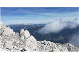 178
178
Discussion about the trail Unterpirkach - Hochstadel (Dreitörlweg)