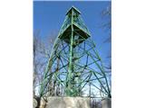
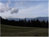
 | Zgornje Poljčane - Boč (via Baba)
Boč is among the last peaks in the Karawanks before they transition over Donačka gora and Macelj into the Pannonian Plain. Boč has two approximat...
1 h 45 min |
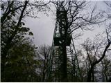
| Zgornje Poljčane - Boč (via Balunjača)
Boč is among the last peaks in the Karawanks before they transition over Donačka gora and Macelj into the Pannonian Plain. Boč has two approximat...
1 h 35 min |
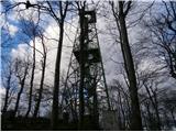
 | Studenice - Boč (by road)
Boč is among the last peaks in the Karawanks before they transition over Donačka gora and Macelj into the Pannonian Plain. Boč has two approximat...
2 h |
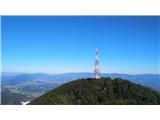
 | Zgornje Poljčane - Boč (on road and Senčna pot)
Boč is among the last peaks in the Karawanks before they transition over Donačka gora and Macelj into the Pannonian Plain. Boč has two approximat...
1 h 50 min |
 | Zgornja Kostrivnica - Boč
Boč is among the last peaks in the Karawanks before they transition over Donačka gora and Macelj into the Pannonian Plain. Boč has two approximat...
2 h |
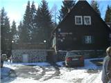
 | Zgornja Kostrivnica - Boč (via Koča Velikonočnica)
Boč is among the last peaks in the Karawanks before they transition over Donačka gora and Macelj into the Pannonian Plain. Boč has two approximat...
2 h |
 | Cerkno - Koča na Ermanovcu (via Kladje)
The mountain hut is situated northwest of Ermanovec below the summit of Štor. From the hut or its nearby surroundings, there is a nice view towar...
2 h 35 min |
| Cerkno - Koča na Ermanovcu (via Planina pri Cerknem)
The mountain hut is situated northwest of Ermanovec below the summit of Štor. From the hut or its nearby surroundings, there is a nice view towar...
2 h 40 min |
 | Dravograd - Dom na Košenjaku
The Dom na Košenjaku mountain hut is situated north of Dravograd on the southern slopes of Košenjak. The view from the hut is mainly limited to t...
2 h 30 min |
 | Dolina Zaplaninščice - Koča na Čemšeniški planini
The Dom dr. Franca Goloba mountain hut on Čemšeniška planina is located at the edge of a large grassy area from which a fine view opens toward Za...
2 h 40 min |
 | Izlake - Koča na Čemšeniški planini
The Dom dr. Franca Goloba mountain hut on Čemšeniška planina is located at the edge of a large grassy area from which a fine view opens toward Za...
2 h 45 min |
| Izlake - Koča na Čemšeniški planini (via Razbor pri Čemšeniku)
The Dom dr. Franca Goloba mountain hut on Čemšeniška planina is located at the edge of a large grassy area from which a fine view opens toward Za...
2 h 55 min |
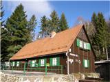
 | Hrastnik - Planinski dom na Kalu (via Klobuk)
The Planinski dom na Kalu mountain hut, formerly known as Planinski rudarski dom na Kalu, is located below the summit of Kal (985 m). Nearby is a...
2 h 15 min |
| Hrastnik - Planinski dom na Kalu (via Ravne)
The Planinski dom na Kalu mountain hut, formerly known as Planinski rudarski dom na Kalu, is located below the summit of Kal (985 m). Nearby is a...
2 h 15 min |
 | Dol pri Hrastniku - Planinski dom na Kalu
The Planinski dom na Kalu mountain hut, formerly known as Planinski rudarski dom na Kalu, is located below the summit of Kal (985 m). Nearby is a...
2 h |
| Hrastnik - Planinski dom na Kalu (via Blate)
The Planinski dom na Kalu mountain hut, formerly known as Planinski rudarski dom na Kalu, is located below the summit of Kal (985 m). Nearby is a...
2 h 10 min |
 | Rimske Toplice (Šmarjeta) - Koča na Kopitniku (via Lurd)
The hut is located northeast of Kopitnik, after which it is also named. In front of the hut, where there are many tables and benches, there is a ...
1 h 40 min |
| Rimske Toplice - Koča na Kopitniku (via Ogeški potok)
The hut is located northeast of Kopitnik, after which it is also named. In front of the hut, where there are many tables and benches, there is a ...
1 h 40 min |
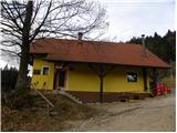
 | Moravče - Dom na Slivni (via Pivkelj)
The Dom na Zgornji Slivni mountain hut is located west of GEOSS on the eastern slopes of Pivkelj peak. Near the closed hut is the church of St. N...
2 h 50 min |
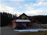
 | Vransko - Dom na Čreti
The Dom na Čreti mountain hut is located north of Vransko on the central part of the Dobroveljska planota plateau. Near the hut are two small chu...
1 h 45 min |
 | Žovneško jezero - Dom na Čreti
The Dom na Čreti mountain hut is located north of Vransko on the central part of the Dobroveljska planota plateau. Near the hut are two small chu...
2 h 30 min |
 | Kokarje (ŠRC Laze) - Dom na Čreti (via Tajna)
The Dom na Čreti mountain hut is located north of Vransko on the central part of the Dobroveljska planota plateau. Near the hut are two small chu...
1 h 40 min |
| Kokarje (ŠRC Laze) - Dom na Čreti (via Dom na Farbanci)
The Dom na Čreti mountain hut is located north of Vransko on the central part of the Dobroveljska planota plateau. Near the hut are two small chu...
2 h |
 | Hrašče - Furlanovo zavetišče pri Abramu (past troughs)
Furlanovo zavetišče pri Abramu is a popular excursion spot located east of the Vipava Valley. A large number of visitors drive right up to the sh...
2 h 45 min |
| Hrašče - Furlanovo zavetišče pri Abramu (via Brižnik)
Furlanovo zavetišče pri Abramu is a popular excursion spot located east of the Vipava Valley. A large number of visitors drive right up to the sh...
2 h 45 min |
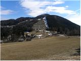
 | Pivola (Reka) - Mariborska koča (via Petkovo sedlo and waterfall Skalca)
Mariborska koča is the first control point of the Slovenian Mountain Trail (SPP). It is located north of Slivniško Pohorje and west of Hočko Poho...
2 h 30 min |
 | Pivola (Reka) - Mariborska koča (via Hočka koča)
Mariborska koča is the first control point of the Slovenian Mountain Trail (SPP). It is located north of Slivniško Pohorje and west of Hočko Poho...
2 h 15 min |
 | Spodnje Radvanje - Mariborska koča
Mariborska koča is the first control point of the Slovenian Mountain Trail (SPP). It is located north of Slivniško Pohorje and west of Hočko Poho...
2 h 40 min |
 | Log - Mariborska koča
Mariborska koča is the first control point of the Slovenian Mountain Trail (SPP). It is located north of Slivniško Pohorje and west of Hočko Poho...
2 h 40 min |
 | Pivola (Reka) - Mariborska koča (via Petkovo sedlo)
Mariborska koča is the first control point of the Slovenian Mountain Trail (SPP). It is located north of Slivniško Pohorje and west of Hočko Poho...
2 h 15 min |
 | Spodnje Radvanje - Mariborska koča (southern path)
Mariborska koča is the first control point of the Slovenian Mountain Trail (SPP). It is located north of Slivniško Pohorje and west of Hočko Poho...
2 h 55 min |
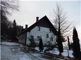
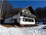
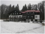
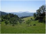
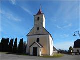
 | Oplotnica - Sveti Trije kralji
Sveti Trije Kralji is a popular excursion spot for Styrian and other mountaineers. Near the Church of the Holy Three Kings is the Jakec guesthous...
2 h 45 min |
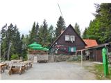
 | Jelovec - Koča na Žavcarjevem vrhu
The mountain hut is located just a few dozen meters below Žavcarjev vrh, on the slopes of Kozjak. From the hut, which is mostly surrounded by for...
2 h 15 min |
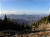
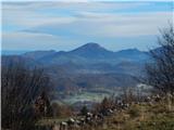
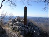 | Vitovlje - Sekulak (via Vitovlje Lake)
Sekulak is a viewpoint on a side ridge of the Čavenski massif. Because Sekulak protrudes from the main ridge line, it offers a wonderful view of ...
1 h 40 min |
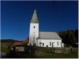 | Dravograd - Church of St. John the Baptist on Ojstrica
The Church of St. John the Baptist on Ojstrica is located on the edge of panoramic pastures where highland cattle usually graze. From the church ...
1 h 45 min |
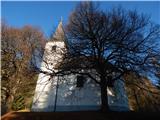
 | Žovneško jezero - Holy Mother of God on Čreta
The Church of the Holy Mother of God on Čreta is located west of the lesser-known forested peak Vrhe. From the church or its immediate surroundin...
2 h 20 min |
| Braslovško jezero - Holy Mother of God on Čreta
The Church of the Holy Mother of God on Čreta is located west of the lesser-known forested peak Vrhe. From the church or its immediate surroundin...
2 h 50 min |
| Letuš - Holy Mother of God on Čreta
The Church of the Holy Mother of God on Čreta is located west of the lesser-known forested peak Vrhe. From the church or its immediate surroundin...
2 h 50 min |
 | Kokarje (ŠRC Laze) - Holy Mother of God on Čreta (via Tajna)
The Church of the Holy Mother of God on Čreta is located west of the lesser-known forested peak Vrhe. From the church or its immediate surroundin...
1 h 40 min |
| Kokarje (ŠRC Laze) - Holy Mother of God on Čreta (via Dom na Farbanci)
The Church of the Holy Mother of God on Čreta is located west of the lesser-known forested peak Vrhe. From the church or its immediate surroundin...
2 h |
 | Lavamünd - St. Lorenzen (Lorenzenberg)
The Church of St. Lorenzen is located on the edge of the village Lorenzenberg, east of Labot/Lavamünd. From the church or its immediate surroundi...
2 h |
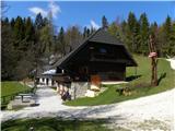
 | Loke - Planinski dom Vrhe
The Planinski dom Vrhe mountain hut is situated on the southeast slopes of Kisovec peak, from where a nice view opens up to the nearby Javor. Nea...
1 h 50 min |
 | Trbovlje - Planinski dom Vrhe
The Planinski dom Vrhe mountain hut is situated on the southeast slopes of Kisovec peak, from where a nice view opens up to the nearby Javor. Nea...
2 h 30 min |
 | Muta (Spodnja Muta) - St. Lorenzen ob Eibiswald
The Church of St. Lovrenc is located on the Austrian side of the Kozjak / Poßruck hills, specifically in the village of Sv. Lovrenc / St. Lorenze...
2 h 55 min |
 | Muta (Zgornja Muta) - Church of St. Simon and Judah Tadej (Pernice)
Pernice is a settlement located between Gortina, Kozji vrh and Bistriški jarek. In Pernice there is the church of St. Simon and Jude Thaddeus, a ...
2 h 45 min |
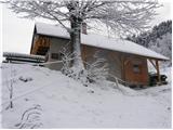
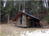 | Radlje ob Dravi - Kapunerhütte (via Župank and hut of amateur radio operators)
Kapunerhütte is a small mountain hut located on the Austrian side of Kapunar. As it lies in the forest, it offers no scenic views....
2 h 45 min |
| Radlje ob Dravi - Kapunerhütte (via old castle and hut of amateur radio operators)
Kapunerhütte is a small mountain hut located on the Austrian side of Kapunar. As it lies in the forest, it offers no scenic views....
2 h 45 min |
 | Brezno - Sveti Urban (Radelca) (along Remšniški potok)
The Church of St. Urban on Radelca stands on the southern slopes of the border ridge Radelj. Built in the mid-17th century amid nearby forest, it...
2 h 30 min |
 | Puščava - Sveti Ignacij (Rdeči Breg)
The Church of St. Ignacij is situated on the periphery of the settlement Rdeči Breg, which rises northwest of Lovrenc na Pohorju and only a littl...
2 h 50 min |
| HE Ožbalt - Sveti Ignacij (Rdeči Breg)
The Church of St. Ignacij is situated on the periphery of the settlement Rdeči Breg, which rises northwest of Lovrenc na Pohorju and only a littl...
2 h 45 min |
 | Podvelka - Sveti Ignacij (Rdeči Breg)
The Church of St. Ignacij is situated on the periphery of the settlement Rdeči Breg, which rises northwest of Lovrenc na Pohorju and only a littl...
1 h 55 min |
 | Zgornja Bistrica (Center Vintgar) - Majalova Chapel (via Bistriški vintgar)
Majalova Chapel is located south of the Majal homestead, from where a nice view opens up onto the nearby surroundings....
2 h 45 min |
 | Puščava - Hunting cottage Klančnik
The Hunting Cottage Klančnik is located just below the Klančnik peak on the panoramic grassy slopes of Rdeči Breg....
2 h 20 min |
| HE Ožbalt - Hunting cottage Klančnik
The Hunting Cottage Klančnik is located just below the Klančnik peak on the panoramic grassy slopes of Rdeči Breg....
2 h 15 min |
 | Podvelka - Hunting cottage Klančnik (via Sveti Ignacij)
The Hunting Cottage Klančnik is located just below the Klančnik peak on the panoramic grassy slopes of Rdeči Breg....
2 h 25 min |
 | Pivola (Reka) - Sveti Bolfenk (Mariborsko Pohorje) (via Petkovo sedlo and Mariborska koča)
The Church of St. Bolfenk on Mariborsko Pohorje is located near the upper station of the funicular and near the Hotel Bellevue....
2 h 50 min |
 | Spodnje Radvanje - Sveti Bolfenk (Mariborsko Pohorje) (on SPP)
The Church of St. Bolfenk on Mariborsko Pohorje is located near the upper station of the funicular and near the Hotel Bellevue....
2 h |
| Spodnje Radvanje - Sveti Bolfenk (Mariborsko Pohorje) (southern path)
The Church of St. Bolfenk on Mariborsko Pohorje is located near the upper station of the funicular and near the Hotel Bellevue....
2 h 15 min |
 | Stubenbergsee - Mariabrunn (via Kulmkögerl)
Mariabrunn is a small chapel located on the western slopes of Kulm peak....
1 h 53 min |
 | Gornja Brela (Subotišće) - Planinska koča Bukovac (Planinska pot)
The Bukovac mountain hut is located at an elevation of 1030 m in a forested valley in the northwestern part of Biokovo, half an hour below the su...
2 h 30 min |
 | Zgornja Bistrica (Center Vintgar) - Pond west of Ošelj (via Bistriški vintgar)
The pond west of Ošelj lies among the Pohorje forests, near the settlements of Smrečno and Ošelj....
2 h 5 min |
 | Ruše - Sveta Marija (Smolnik)
The Church of Holy Mary is situated at the edge of the forest and on the periphery of the hamlet Hlebovo, near the settlement Smolnik....
2 h 5 min |
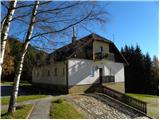
 | Pivola (Reka) - Hotel Tisa (Poštarski dom) (via Petkovo sedlo)
Hotel Tisa, the former Poštarski dom, is situated at the edge of the Hočko Pohorje forests. The hotel, known for its original Pohorje omelette, o...
1 h 45 min |
| Fram - Hotel Tisa (Poštarski dom) (via Petkovo sedlo)
Hotel Tisa, the former Poštarski dom, is situated at the edge of the Hočko Pohorje forests. The hotel, known for its original Pohorje omelette, o...
2 h 30 min |
| Slivnica pri Mariboru - Hotel Tisa (Poštarski dom)
Hotel Tisa, the former Poštarski dom, is situated at the edge of the Hočko Pohorje forests. The hotel, known for its original Pohorje omelette, o...
2 h 30 min |
 | Dolina Sopote (Zagrad) - Sveta Trojica (Čimerno)
The Church of the Holy Trinity is located in the settlement of Čimerno, along the marked trail from Radeče and Zagrada toward Kum and Nebeška gor...
1 h 40 min |
 | Muta (Zgornja Muta) - Arl's Pine
Arlov bor has been protected since 2010 as a local, municipal, and natural landmark due to its unique and unusual growth.From the pine, where a v...
2 h 30 min |